
Philadelphia Streets Department Surveys
2755 result(s). Showing results 1 to 50.
View page: 1 2 3 4 5 6 7 8 9 10 11 12 13 14 15 16 17 18 19 20 21 22 23 24 25 26 27 28 29 30 31 32 33 34 35 36 37 38 39 40 41 42 43 44 45 46 47 48 49 50 51 52 53 54 55 56 (Show all on one page)
| Identifer | Preview | Title | Surveyor | Date | Media / Size / Scale | Area / Map Features |
| 001-01 HP |
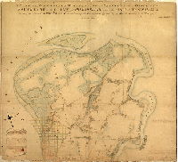
|
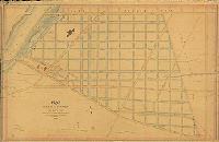
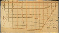
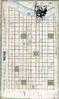
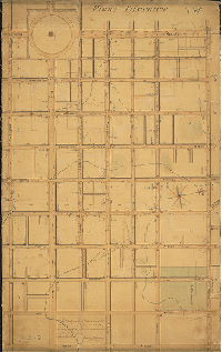
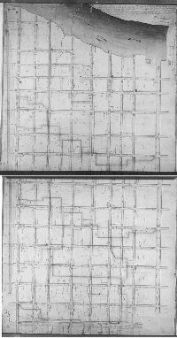
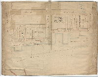
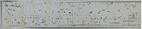
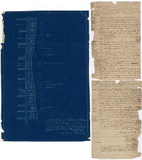
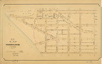
Plan of Moyamensing, Southwark, Passyunk &c. within the limits, from South St. to Delaware River on the south and from the Delaware River on the east to the Schuylkill River on the west. Approved by Commissioners. Directed by an Act of the General Assembly, Sept. 29. 1787. John Hills, Surveyor. | Hills, John | 1788 |
Mounted
72 x 78 in.
|
South Philadelphia. Entire area bounded by South St., Delaware River and Schuylkill River, including League Island
Streams, marshland, river bank, vegetation, farms, building footprints, existing roads, proposed street grid for Southwark
|
| 001-z HP |
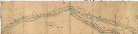
|
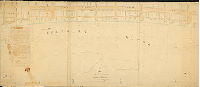
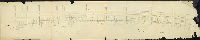
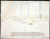
Survey of the road on the bank of the Schuylkill [River] from the Passyunk road to Gallows Lane. Thomas S. Stewart, Engin. Scale of 60 ft. to the inch. Septm. 13th 1840. | Stewart, Thomas S. | 1840 |
Mounted
14 x 55 in.
1 inch = 60 feet
|
South Philadelphia. Road along east bank of Schuylkill River from Passyunk Rd. to Gallows Lane.
River bank, benchmarks including trees, taverns including the Golden Swan and Hamburgh, property lines and owners, building footprints. Text on reverse reads: "No. 1. Plan of road along Schuylkill River. Road from Swan Tavern to Gallows Lane. Sept. 1, 1841."
|
| 002-01 HP |
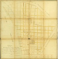
|
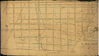
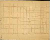
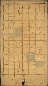
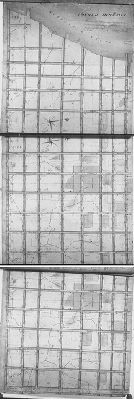
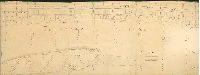
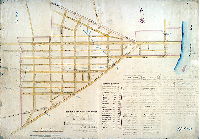
A plan of the District of Southwark situated in the County of Philadelphia in the State of Pennsylvania shewing the intended new roads as laid out by the Commissioners appointed by the General Assembly in the year 1788. Surveyed by John Hills, 1788. | Hills, John | 1788 |
Mounted, folds into protective boards
74 x 73 in.
1 inch = 300 feet
|
South Philadelphia, Southwark District. Bounded by Cedar (now South) St., Delaware River, Passyunk Rd. and boundary with Moyamensing Township
Property lines and owners, existing and proposed streets; wharves and streets projected over the Delaware River
|
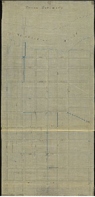
| 003-01 HP |
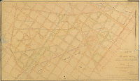
|
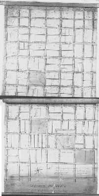
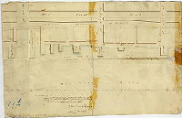
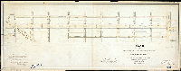
Plan of the southern part of Moyamensing locating & establishing the line of streets, curb heights, & decents [descents] of water courses, pursuant to Acts of Assembly passed April 13, 1835 [and] March 2, 1838 | Stewart, Thomas S. | 1838 |
Mounted
29 x 50 in.
1 inch = 150 feet
|
South Philadelphia. Moyamensing. Bounded by Wolf to Federal Sts., 2nd to 16th Sts.
Moyamensing Prison; Delaware & Schuylkill Canal; Parade Ground behind Moyamensing Prison; Lafayette Cemetery; Catholic Cemetery; T. Landreth property; Shackhansing Creek; "ditch and water course"; curb heights; property lines aand owners; color-coded building footprints
|
| 003-01 HP attachment |
|
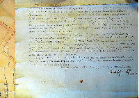
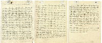
[Resolution of the Moyamensing commissioners made June 24, 1842, certifying plan 003-01_HP ] | 1842 |
Paper
|
South Philadelphia. Moyamensing. Bounded by Wolf to Federal Sts., 2nd to 16th Sts.
Attachment
|
|
| 004-01 HP |
|
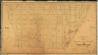
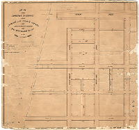
Plan of the streets in the Township of Passyunk between Schuylkill River and the Moyamensing Township line and between Cedar Street and the Buck Road laid out in 1832. Lemuel Paynter, William G. Alexander, Fredrick G. Wolbert, Commissioners. John Thompson, Surveyor. The report accompanying this plan was filed December 28th, 1832 and confirmed absolutely April 28th, 1833. | Thomson, John | 1832 |
Mounted
35 x 54 in.
1 inch = 150 feet
|
South Philadelphia. Passyunk Township. Bounded by Broad St. to Schuylkill River, South to Dickinson Sts.
Chickhansing Creek; U.S. Arsenal; U. S. Naval Asylum; "Old glass house"; footprints of a dozen buildings close to street lines, with names of owners; property lines; creeks; high and low tide lines; annotations on street openings and closings to 1850
|
| 004-01 HP attachment |
|
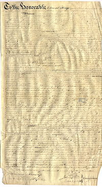
Report of the commissioners appointed by Act of Assembly to survey Passyunk Township [related to plan 004-01_HP] | 1832 |
Paper
|
South Philadelphia. Passyunk Township. Bounded by Broad St. to Schuylkill River, South to Dickinson Sts.
Attachment
|
|
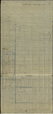
| 005-01 HP |
|
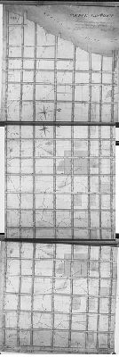
A plat [of the] north part of the Township of Moyamensing in the County of Philadelphia, January 1st,1811. Surveyed and delineated by Reading Howell. | Howell, Reading | 1811 |
Mounted
42 x 73 in.
1 inch = 80 feet
|
South Philadelphia. Moyamensing. Bounded by South to Federal Sts. 5th to 17th Sts.
Property lines; property owners; many color-coded building footprints; deed and later elevation annotations; creeks and ditches; existing roads in pink tint, projected streets in light blue; "C. D. Howell, ex." [son of Reading Howell, who probably worked on the plan as a draftsman]
|
| 005-01 HP calculationbook RG214.14 |
|
The general regulation, both of the street lines and draining of the surface of the incorporated part of the Township of Moyamensing, bounded on the N. by Cedar Street, on the S.E. by the Passyunk road, on the S. by Federal Street, and on the W. by the E. | Howell, Reading | 1811 |
Bound volume
|
South Philadelphia. Moyamensing
Calculation Book
|
| 005-02 HP |
|
A plat of the north part of the Township of Moyamensing in the County of Philadelphia. 1829 Aug. 29th, surveyed and delineated by David Coombs. … B. Coombs ex. Confirmed absolutely Ap'l. 27 1830, Road Book Vol. 10 p. 404 | Coombs, David | 1829 |
Mounted
44 x 76 in.
1 inch = 80 feet; or perhaps 4 perches to the inch.
|
South Philadelphia. Moyamensing. Bounded by South to Federal Sts., 5th to 17th Sts.
Existing and proposed streets
|
| 005-02 HP attachment |
|
[No title. Official submittal of plan 005-2_HP from the Commissioners of Moyamensing Township to the Court of Quarter Sessions] | 1829 |
Vellum
29 x 16 in.
|
Moyamensing. South Philadelphia. Bounded by South to Federal Sts., 5th to 17th Sts.
Attachment
|
|
| 005-03 HP |
|
Plan of the Northern Division of the Township of Moyamensing exhibiting the regulated heights of the streets as determined by E. H. Gill and J. C. Trautwine, Civil Engineers. In accordance with the resolution of a committee appointed by the Board of Commissioners for that purpose dated Jany. 21st 1834. | Gill, E. H.; Trautwine, J. C. | 1834 |
Mounted
29 x 51 in.
1 inch = 125 feet
|
South Philadelphia. Moyamensing. Bounded by South to Federal Sts., 5th to 17th Sts.
Hospital Square, Almshouse Square. curb elevations, creeks
|
| 006-01 HP |
|
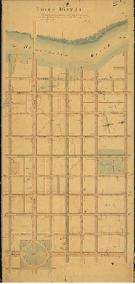
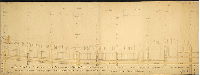
A ground plat of the City of Philadelphia marking the ascents and descents of streets, elevation for the regulated curbstones, and exhibiting the main tunnels &c. For particulars see the book corresponding herewith. March15th 1809. Reading Howell. | Howell, Reading | 1809 |
Mounted
47 x 79 in.
1 inch = 150 feet
|
Philadelphia, Reading Howell. Bounded by 5th St. to Schuylkill River, South St. to Vine St.
Centre Square with circular pathways, Water Works at Schuylkill River and Chestnut Street, sewer profiles on Pine St. and Mulberry St.; drainage areas outlined, streams (not named on plan) including Minnow Run, Dock Creek, parts of Pegg's Run; original and proposed curb elevation, clay pits, benchmark buildings
|
| 006-v HP |
|
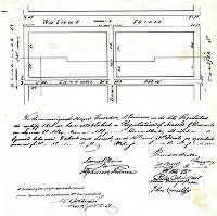
Regulation of ascents & descents Lyndall's Alley (now Chancellor Street) … and Dean Street … between Walnut and Locust, and 12th and 13th Streets | Hains, Samuel; Ireland, Alphonso | 1820 |
Tracing
12 x 12 in.
|
Philadelphia. Alleys in block bounded by Walnut and Locust Sts., 12th and 13th Sts.
Curb elevations. Weaver's Alley is mentioned in title block, but that part of the original plan was not copied in this tracing.
|
| 006-w HP |
|
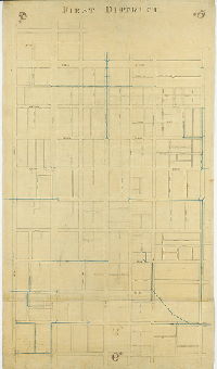
First District [Tracing based on Reading Howell's First District plan, 007-01_HP, focusing on sewers] | Not named | 1815 ca. |
Tracing
46 x 26 in.
|
Philadelphia. Bounded by Fifth St. to Broad St., Vine St. to Chestnut St.
Street lines, sewers and sewer inlets
|
| 006-x HP |
|
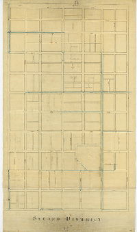
Second District [Tracing based on Reading Howell's Second District plan, 008-03_HP, focusing on sewers] | Not named | 1815 ca. |
Tracing
46 x 26 in.
|
Philadelphia. Bounded by Fifth St. to Broad St., Chestnut St. to Cedar (now South) St.
Street lines, sewers and sewer inlets
|
| 006-y HP |
|
Third District [Tracing based on Reading Howell's Third District plan, 009-01_HP, focusing on sewers] | Not named | 1815 ca. |
Tracing
54 x 26 in.
|
Philadelphia. Bounded by Broad St. to Schuylkill River, Vine St. to Chestnut St.
Street lines, sewers and sewer inlets
|
| 006-z HP |
|
Fourth District [Tracing based on Reading Howell's Fourth District plan, focusing on sewers] | Not named | 1815 ca. |
Tracing
56 x 26 in.
|
Philadelphia. Bounded by Broad St. to Schuylkill River, Chestnut St. to Cedar (now South) St.
Street lines, sewers and sewer inlets, calculations for drainage area related to sewer along Cedar Street, corner elevations
|
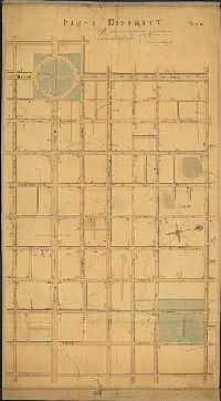
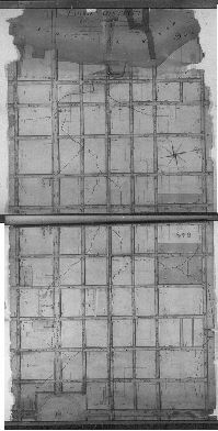
| 007-01 HP |
|
First District. In obedience to an ordinance dated May 1804, surveyed, leveled, and adjusted that part of the City Plat comprehended within this draft. Reading Howell. | Howell, Reading | 1804 ca. |
Mounted
47 x 26 in.
1 inch = c. 125 feet
|
Philadelphia, Reading Howell, First District. Bounded by 5th St. to Board St., Chestnut St. to Vine St.
Centre Square with pumping station; pink and yellow building footprints; creeks; sewers; street ascents and descents; original and proposed curb elevations
|
| 007-02 HP |
|
Plan of the regulation of Letitia Street in the City of Philadelphia made in pursuance of a resolution of Councils passed the 8th day of May A.D. 1856. by Joseph H. Siddall, surveyor and regulator of the 5th District. May 17th, 1856 … November 23rd 1857, confirmed by Court. | Siddall, Joseph H. | 1856 |
Mounted
23 x 18 in.
1 inch = c. 33 feet
|
Philadelphia. Bounded by Front to 2nd Sts., Chestnut to Market Sts.
Curb elevations
|
| 007-03 HP |
|
First District. In obedience to an ordinance dated May 1804, surveyed, regulated & adjusted that part of the City Plat comprehended in the above draft. March 23rd, 1808. Reading Howell. | Howell, Reading | 1808 |
Mounted
41 x 25 in.
1 inch = c. 125 feet
|
Philadelphia, Reading Howell, First District. Bounded by 5th St. to Board St., Chestnut St. to Vine St.
Centre Square with pumping station; pink and yellow building footprints; creeks; sewers; street ascents and descents; original and proposed curb elevations
|
| 008-01 HP |
|
Plan describing the alterations in the regulation of ascents, descents and common sewers in that part of the City lying between Delaware 8th and Schuylkill Eighth [15th] Streets, and between Walnut and Cedar Streets. [Approved by Councils October 3, 1816] | Hains, Samuel | 1816 |
Paper
26 x 34 in.
|
Philadelphia. Bounded by 8th to 15th Sts., Walnut to Cedar (South) Sts.
Streams (Shackhanson Creek and branch of Dock Creek), sewers, building footprints, curb elevations
|
| 008-01 HP attachment |
|
[Letter dated May 18, 1816, from Samuel Hains and Alphonso Ireland, City Regulators, to the Mayor and Recorder of the City of Philadelphia, regarding improvements that could be "made in the southern part of the City between Delaware Eighth and Broad Streets" and represented in plan 008-01_HP] | Hains, Samuel | 1816 |
Paper
|
Philadelphia. Bounded by 8th to 15th Sts., Walnut to Cedar (South) Sts.
Attachment
|
| 008-02 HP |
|
Second District, in obedience to an ordinance dated May 1804, surveyed, leveled, and adjusted that part of the City Plat comprehended in the above draft. March 23rd 1808. Reading Howell. | Howell, Reading | 1808 |
Microfilm Only
|
Philadelphia, Reading Howell, Second District. 4th to Broad, Chestnut to South
|
| 008-03 HP |
|
Second District. In obedience to an ordinance dated May 1804, surveyed, leveled, and adjusted that [part of the] City Plat comprehended in the above draft. Reading Howell. | Howell, Reading | 1804 ca. |
Mounted
47 x 26 in.
1 inch = c. 125 feet
|
Philadelphia, Reading Howell, Second District. Bounded by 4th to Broad Sts., Chestnut to South Sts.
Almshouse Square, Hospital Square, State House Square, jail and workhouse on 6th, pink and yellow building footprints; creeks; sewers; street ascents and descents; original and proposed curb elevations
|
| 009-01 HP |
|
Third District. In obedience to an ordinance dated May 1804, surveyed, leveled, and adjusted that part of the City Plat comprehended within this draft. Reading Howell. | Howell, Reading | 1808 |
Mounted
57 x 26 in.
1 inch = c. 125 feet
|
Philadelphia, Reading Howell, Third District. Bounded by Broad St. to Schuylkill River, Chestnut to Vine Sts.
Center Square with Engine house, Logan Square with creeks, Water Works basin; Arch St. Prison; Minnow Run; Market St. Permanent Bridge; building footprints; creeks; sewers; street ascents and descents; original and proposed curb elevations; mud flats along Schuylkill
|
| 009-02 HP |
|
[No title. Front St. to Schuylkill River, Vine St. to South St. Plan originally extended farther east, perhaps all the way to the Delaware River, but that section is missing] | Not named | 1790 ca. |
Mounted
30 x 57 in.
1 inch = c. 200 feet
|
Philadelphia. Bounded by Front St. to Schuylkill River, Vine St. to South St.
Delineation of Dock Creek other creeks, springs, and marshland; burying ground in Franklin Square; elevations ("descents and ascents" marked as D and A) of streets to be built; etc.
|
| 009-03 HP |
|
Third District. In obedience to an ordinance dated May 1804, surveyed, leveled, and adjusted that part of the City Plat comprehended within this draft. March 23, 1808. Reading Howell. | Howell, Reading (probably) | 1808 |
Paper
25 x ____ in.
1 inch = c. 200 feet
|
Philadelphia, Reading Howell, Second District, 1804
|
| 010-01 HP |
|
We the undersigned City Regulators do certify that this is [?] plan describing the directions of ascents, descents and common sewers in that part of the City lying between High and Cedar Streets & between Broad Street & the River Schuylkill which was reported by us. Approved by the Select and Common Councils the 2d day of October 1817 and by them directed to be recorded agreeable to the 10th Section of an Ordinance authorizing the Mayor to appoint City Regulators or Surveyors and establishing an office preserving the Records of their proceedings and for other purposes, signed the 6th day of August 1814. | Howell, Reading; Hains, Samuel | 1817 |
Microfilm Only
|
Bounded by Broad St. to Schuylkill River, High (Market) St. to Cedar (South) St.
|
| 010-02 HP |

|
Plan showing widening of footways on the south side of Market St. between Twenty-Second Street and the bridge. As per resolution of Councils. Approved June 9, 1875. Confirmed by Board of Surveyors, January 17, 1876. | Shedaker, David Hudson | 1876 |
Mounted
11 x 23 in.
1 inch = 50 feet
|
Philadelphia. Market St., 22nd St. to Schuylkill River
City railroad, West Philadelphia Passenger Railway, City Gas Works, curb elevations
|
| 010-03 HP |
|
Fourth District, In Obedience to an Ordinance dated May 1804, Surveyed, leveled, and Adjusted that part of the City Plat comprehended within this Draft. Reading Howell | Howell, Reading | 1804 c. |
Microfilm Only
|
Philadelphia, Reading Howell, Fourth District. Broad to Schuylkill, Chestnut to South.
building footprints; ascents and descents; clay pits in block interiors; watercourses; surveying stones
|
| 010-04 HP |
|
Plan of the revision of grades between Market and Walnut streets and Twenty-Second Street and the Schuylkill River in the Eighth and Ninth Wards. Authorized by Councils Feny. 10th, 1872. | Shedaker, David Hudson | 1872 |
Mounted
28 x 29 in.
1 inch = 50 feet
|
Philadelphia. Bounded by 22nd St. to Schuylkill River, Walnut to Market Sts.
Abutments for bridges; Port Warden's lines; curb elevations; annotations through 1899
|
| 010-05 HP |
|
Fourth District, In obedience to an ordinance dated May 1804, surveyed, leveled, and adjusted that part of the City Plat comprehended within this draft. March 23rd 1808. Reading Howell | Howell, Reading | 1808 |
Microfilm Only
|
Philadelphia, Reading Howell, Fourth District. Bounded by Broad St. to Schuylkill River, Chestnut to South Sts.
|
| 011-01 HP |
|
[Handwritten title on reverse: "Delaware Avenue From Pine to Cedar St., Filed July 29th 1839" According to Plan Book 1, in Streets Dept., City Plans Unit, this plan was made "to accompany report of [road] jury to Court of Quarter Sessions] | Hains, Samuel (probably) | 1839 |
Mounted
12 x 15 in.
1 inch = 50 feet
|
Delaware River front, from Pine to South Sts.
Building footprints in street, property owners
|
| 011-02 HP |
|
To the Select and Common Councils of the City of Philadelphia, this delineation of that part of the harbour opposite the said City, of the public wharves, breadth of the channel to the island and bar, and depth of the water opposite the principal streets, is respectfully inscribed by their friend to serve, James Pearson, Surveyor, Philadelphia 1805. | Pearson, James | 1805 |
Paper
21 x 57 in.
|
Delaware River front, Philadelphia.
G. Clymer's wharf on the Island, fish house on Dock street, soundings in channel, sand bars, wharf owners, wharf widths, alleys from Water St.
|
| 011-03 HP |
|
The above is the plan of Water Street, referred to in an ordinance for laying out "Water Street anew," as having been made by and under the authority of the Councils of the City of Philadelphia. Samuel Hains, City Surveyor. | Hains, Samuel | 1832 |
Microfilm Only
|
Delaware River front. Water St. from Spruce St. to Vine St.
Wharves, benchmark buildings
|
| 011-04 HP |
|
A plan of the streets wharves etc. between Dock and Chestnut St. shewing a proposed extension of the wharf at Walnut Street 90 ft. in length eastward by 50 feet in breadth north and south. Pr Samuel Hains February 18th 1834. | Hains, Samuel | 1834 |
Mounted
12 x 19 in.
1.25 inch = 100 feet
|
Delaware River front, between Dock St. and Chestnut St., Front St. to Delaware River
Wharves
|
| 011-05 HP |
|
Draft of the East Front of the City of Philadelphia on the River Delaware from Cedar to Vine Streets, exhibiting the public and private wharves, and docks, with the indented front line formed by the buildings, with the front dimensions and definitions of the respective properties, and depth of water found in the line of each street across the channel, to the Island and sand bars. This survey and delineation of the eastern front of the City was executed by the subscriber in conformity to a resolution of the City Councils dated 25 April 1811, for the use of the Wardens of the Port, a duplicate of which is deposited in their office. Philadelphia, 16th September 1811. Reading Howell. Copy [by] W. Morrell April 1905. | Howell, Reading | 1811 |
Tracing
24 x 115 in.
|
Delaware River front, Philadelphia.
Wharves, property owners, sand bars and rushes
|
| 011-06 HP |
|
Plan of the Delaware [River] Front of the City shewing the wharf line as fixed by the City Councils and approved by the Wardens. | Not named | 1836 |
Mounted
29 x 70 in.
1/10 foot = 100 feet [1.2 inch = 100 feet]
|
Delaware River front, Philadelphia.
Delaware Ave. as projected, [Windmill Island], "Water Street as laid out anew," soundings, wharves, attachment: referencing ordinance of Sept. 1, 1836
|
| 011-07 HP |
|
Plan of the Delaware Front of the City, shewing the wharf line as fixed by the City Councils and approved by the Wardens. N.B. The island sandbars and soundings were taken at low water mark, together with alteration proposed 1843 [Attachment: copies of authorizing legislation] | Not named | 1843 |
Mounted
27 x 72 in.
1/10 foot = 100 feet [1.2 inch = 100 feet]
|
Delaware River front, Philadelphia.
Delaware Ave. as projected, "Water Street as laid out anew," soundings, wharves, mud and sand dimensions on Windmill Island
|
| 011-07 HP attachment |
|
[Copies of ordinances and resolutions related to plan 11-07_HP and the wharf line shown therein] | Not named | 1844. |
Paper
|
Delaware River front, Philadelphia.
Attachment
|
| 011-y HP |
|
A draft describing the alleys and passages leading from Delaware Front Street to Water Street and from thence to the river -- with their dimensions and distance from each other, and the principal streets -- the small alleys that are colorered [sic] are supposed to be those laid out by virtue of the regulation of the banks. Samuel Hains, June 23rd 1820. [Attachment: report from Samuel Hains for Joseph Lewis, on the legal status of the alleys and passages depicted in the plan, June 6, 1820] | Hains, Samuel | 1820 |
Blueprint
21 x 14 in.
|
Delaware River front, alleys and steps between Water St. and Delaware Ave.
Steps and alleyways leading up into the city from the level of the Delaware River
|
| 011-z HP |
|
[No title. Delaware River front, Vine St. to South St., Front St. to Delaware River] | Hains, Samuel | 1820 ca. |
Paper
13 x 71 in.
1.2 inch = c. 100 feet
|
Delaware River front, Philadelphia.
Property ownership along course of proposed Delaware Ave., pink edges may reflect building lines
|
| 012-01 HP |
|
Plan of the streets in the Borough of West Philadelphia with the heights & grades; drawn in May 1847 by Nathan Suplee. | Suplee, Nathan | 1847 |
Mounted
28 x 40 in.
1 inch = 200 feet
|
West Philadelphia Borough. Bounded by Schuylkill River to 40th St., Woodland Ave. to Lancaster Turnpike
Borough line, unidentified streams, bridges over creeks, springs, notes on cuts and fills
|
| 013-01 HP |
|
Plan of Spring Garden Street west of Broad Street showing the adjustment of grades consequent upon the widening of the footways [Resolution April 28, 1860; surveyed 1862; approved Dec. 1, 1862] | Roberts, Edward D. | 1862 |
Mounted
19 x 49 in.
1 inch = 100 feet
|
Spring Garden St. Bounded by Brandywine to Buttonwood Sts., Broad St. to 23rd St.
Curb elevations
|
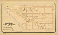
| 013-02 HP |
|
Plan striking from the City Plan a portion of the Park Boulevard. Fifteenth Ward, Philadelphia. [Ordinance Dec. 14, 1894; survey returned Feb. 20, 1895; confirmed March 18, 1895] | Bloch, Frits | 1895 |
Mounted
25 x 42 in.
|
Benjamin Franklin Parkway
Curb elevations
|
| 013-03 HP |
|
Plan of the lines and grades of a portion of the Park Boulevard, Fifteenth Ward, Philadelphia [Ordinance April 12, 1892; survey returned April 1893; confirmed June 12, 1893] | Thayer, W. W. | 1893 |
Mounted
26 x 44 in.
|
Benjamin Franklin Parkway
Curb elevations
|
| 013-04 HP |
|
Plan of Powelton Avenue in the 15th and 24th Wards [Resolution March 2, 1857; approved Nov. 16, 1857; confirmed by Court Dec. 8, 1858] | Stiles, Amos | 1857 |
Mounted
32 x 21 in.
1 inch = 100 feet
|
West Philadelphia. Powelton Ave., from 23rd to 31st Sts.
Curb heights, block dimensions, sidewalks, sewers, wharf and channel lines
|
| 013-05 HP |
|
Plan of change of grades of Poplar Street, between Twenty-ninth Street and Pennsylvania Avenue [Resolution April 28, 1865; approved Jan. 15, 1866] | Roberts, Edward D. | 1865 |
Mounted
23 x 24 in.
1 inch = 60 feet
|
Poplar St.. Bounded by 23rd St. to Pennsylvania Ave., Girard Ave. to Parrish St
Topographic hachure marks, railroad in Pennsylvania Ave., curb elevations
|
| 013-06 HP |
|
In the matter of the plan of revision of grades on Landing Avenue in the 15th Ward [Survey returned Oct. 20, 1856; approved by Board of Surveyors June 15, 1857; confirmed by Court Dec. 8, 1858] | Stiles, Amos | 1857 |
Mounted
17 x 22 in.
1 inch = 50feet
|
15th Ward. Landing Ave., from Coates St. northward.
Schuylkill River, profile of Coates St. approach to bridge, docks by Landing Ave.
|