
Philadelphia Streets Department Surveys
2755 result(s). Showing results 601 to 650.
View page: 1 2 3 4 5 6 7 8 9 10 11 12 13 14 15 16 17 18 19 20 21 22 23 24 25 26 27 28 29 30 31 32 33 34 35 36 37 38 39 40 41 42 43 44 45 46 47 48 49 50 51 52 53 54 55 56 (Show all on one page)
| Identifer | Preview | Title | Surveyor | Date | Media / Size / Scale | Area / Map Features |
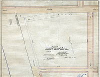
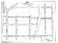
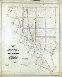
| 163-07 MTD |

|
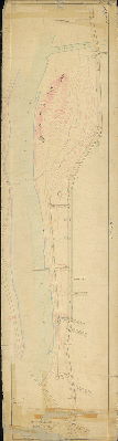
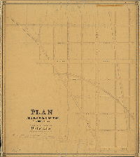
Topographical survey between Coulter St. and School Lane from Ridge Avenue to Wissahickon Avenue in the Twenty-eighth Ward Philadelphia. [Ordinance June 17, 1886] | Datesman, George E. | 1886 ca. |
Mounted
20 x 80 in.
|
28th Ward. Bounded by Ridge to Wissahickon Aves., Coulter St. to School [School House] Lane.
Topography, with many details: planted trees and woodland, building footprints (with one marked 'in ruins'), streams, springs, ponds, marshland
|
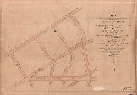
| 163-11 MTD |
|
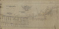
Plan of the lines and grades of Ridge Avenue [Resolution June 24, 1871; confirmed March 17, 1873] | Not named | 1873 |
Mounted
18 x 68 in.
|
Ridge Avenue
Topography, rock outcrops along Schuylkill River, Wissahickon Creek, benchmark buildings
|
| 164-01 HP |
|
Plan showing the revision of lines and grades of Grays Ferry Avenue between Washington Ave. and 36th Street and streets intersecting the same and vacating 29th St. | Nobré, John M. | 1906 |
Tracing
22 x 46 in.
|
South Philadelphia
Curb elevations, Philadelphia, Baltimore and Washington Railroad
|
| 164-02 HP |
|
Plan of revision on the lines and grades of part of Plan 164. Wharton to Tasker and 22nd to 33rd Sts. 36th Ward. [Ordinance April 4, 1894; confirmed 1894 and 1913] | Daly, Thomas | 1894 |
Mounted
22 x 68 in.
|
South Philadelphia. Bounded by Wharton to Tasker Sts., 22nd to 33rd Sts.
Curb elevations
|
| 164-03 HP |
|
Plan showing the revision of lines and grades on that portion of Plan 164 between Thirty-fifth Street and Schuylkill River, Reed and Tasker Streets, Thirty-sixth Ward, Philadelphia [Ordinance March 5, 1901; confirmed July 15, 1901] | Nobré, John M. | 1901 |
Mounted
17 x 26 in.
1 inch = 100 feet
|
South Philadelphia. Bounded by Reed to Tasker Sts., 35th St. to Schuylkill River
Building footprints, railroad
|
| 164-04 HP |
|
Plan striking from city plan and vacating Schuylkill Avenue Wharton to Grays Ferry Road Thirty-sixth Ward, Philadelphia | Dale, Joseph | 1894 |
Mounted
|
South Philadelphia. Bounded by Wharton St, 36th St., Gray's Ferry Ave and Schuylkill Ave.
Curb regulations, railroad
|
| 164-05 HP |

|
Plan showing revision of lines and grades over territory bounded by Ellsworth St., Twenty-ninth St., Grays Ferry Road, Thirty-third St., Tasker St. and Schuylkill River. Twenty-Sixth Ward, Philadelphia. | Daly, Thomas | 1892 |
Mounted
38 x 50 in.
|
South Philadelphia, 26th Ward. Bounded by Ellsworth St., 29th St., Grays Ferry Road, 33rd St., Tasker St. and Schuylkill River.
Curb regulation, Port Wardens and bulkhead lines, Schuylkill River East Side Railroad, sash iron works, Kalion Chemical Co.
|
| 164-06 HP |

|
Plan of the survey and regulation of the southwestern portion of the late District of Moyamensing, as authorized by Act of Assembly approved March 29th, 1849 | Daly, Thomas |
Mounted
|
Moyamensing, southwestern section. Carpenter to Tasker, 22nd to 36th, Schuylkill River
U.S. Arsenal, Gray's Ferry Bridge, about 30 building footprints
|
|
| 164-06 HP tracing |

|
Plan of the survey and regulation of the southwestern portion of the late District of Moyamensing, as authorized by Act of Assembly approved March 29th, 1850 | Daly, Thomas | 1861 |
Tracing
38 x 85 in.
1 inch = 100 feet
|
Moyamensing, southwestern section. Bounded by 22nd St., Tasker St. Schuylkill River and Carpenter St.
U.S. Arsenal, Gray's Ferry Bridge, about 30 building footprints, railroad
|
| 164-07 HP tracing |

|
Plan showing the revision of lines and grades in the Twenty-sixth & Thirtieth Wards Philadelphia. [Ordinances 1874 and 1878; confirmed 1888] | Not named | 1878 ca. |
Tracing
36 x 81 in.
1 inch = 100 feet
|
South Philadelphia. Bounded by Schuylkill River to 22nd St., Tasker Ave. to Carpenter St.
Topography, streams, river bank, clay pits, ponds
|
| 164-27 HP |
|
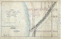
Plan of Wharton Square between Wharton and Reed Sts. and Twenty-third and Twenty-fourth Sts. Thirty-sixth Ward Philadelphia. Containing 3-81/100 acres. [ Ordinance April 11, 1890; survey returned May 1, 1895.] | Daly, Thomas | 1895 |
Blueprint
18 x 22 in.
|
South Philadelphia
Jacob E. Ridgeway House and surrounding topography
|
| 164-x HP |
|
Plan showing revision of lines and grades over part of Plan 164 | Daly, Thomas | 1900 ca. |
Blueprint
36 x 51 in.
|
South Philadelphia
Curb regulation, Port Wardens and bulkhead lines, Schuylkill River East Side Railroad
|
| 165-02 MTD copy |
|
Plan of the Third Section of the survey and regulation of Chestnut Hill, Twenty-second Ward, Philadelphia. [Copy of original plan made ca. 1900.] | Lightfoot, Jesse | 1860 |
Mounted
40 x 65 in.
|
Chestnut Hill, 22nd Ward, 3rd Section. Bounded by Indian to Chestnut Hill Aves., County Line Rd. to 31st St.
Curb elevations, stream and spring
|
| 165-03 MTD |

|
Plan of revision of Evergreen Avenue as directed by resolution of Councils October 13, 1869. [Survey returned Oct. 19, 1869; confirmed by Court Nov. 29, 1869] | Lightfoot, Jesse | 1869 |
Mounted
20 x 26 in.
|
Bounded by Summit St. to Union Ave., Germantown Ave. to County Line Rd.
Curb elevations, railroad
|
| 165-03 MTD tracing |
|
Plan of revision of Evergreen Avenue as directed by resolution of Councils October 13, 1869. [Survey returned Oct. 19, 1869; confirmed by Court Nov. 29, 1869] | Lightfoot, Jesse | 1869 |
Tracing
19 x 26 in.
|
Bounded by Summit St. to Union Ave., Germantown Ave. to County Line Rd.
Curb elevations, railroad
|
| 165-05 MTD |

|
Plan of revision of grade on Highland Ave. from Germantown Ave. to 30th Street [Resolution June 20, 1882; confirmed Feb. 6, 1888] | Jones, Walter | 1888 |
Mounted
30 x 12 in.
|
Chestnut Hill. Bounded by 30th (Seminole) St. to Germantown Ave., Union Ave. to Evergreen Ave.
Curb elevations
|
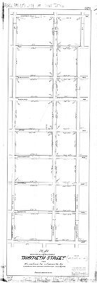
| 165-07 CP |
|
Plan of revision of lines and grades of Thirtieth Street [Seminole Ave.] from Willow Grove Ave. to Chestnut Hill Ave. [Ordinance June 21, 1882; confirmed Oct. 5, 1891] | Not named | 1891 |
Mounted
48 X 17 in.
|
Bounded by Chestnut Hill Ave. to Willow Grove Ave., 29th (Navajo) to 31st (St. Martin's) Sts.
Curb elevations
|
| 166-01 FLAT |

|
Plan of Regent St. (Sq.) from 42nd St. to 43rd St. in the 27th Ward, Philad'a. [Ordinance Feb. 10, 1892; confirmed Mar 31, 1892] | Jones, William H. | 1892 |
Tracing
13 x 11 in.
|
West Philadelphia
Curb elevations, building footprints
|
| 166-01 MTD |
|
Plan of revision of lines and grades of that portion of the Twenty-seventh Ward of the City of Philadelphia embraced in the limits of Plan No. 166 on file in the Department of Surveys [Ordinance Dec. 31, 1875; confirmed Feb. 4, 1878] | Jones, William H. | 1878 |
Mounted
|
West Philadelphia
Mill Creek, pond, building footprints
|
| 166-02 FLAT |
|
Plan of Delancey Street from Forty-second St. eastward 150 ft., 27th Ward, Philadelphia, as directed to be placed on the City Plan [Ordinance March 30, 1894; confirmed Sept. 3, 1894] | Jones, William H. | 1894 |
Tracing
10 x 13 in.
|
West Philadelphia
Curb elevations, building footprints
|
| 166-02 MTD |

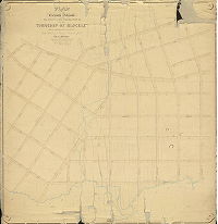
|
Plan of the revised grade regulation of the Fourth Section of West Philadelphia together with a survey and regulation of a portion of the late Township of Blockley adjoining [Resolutions 1858 and 1859; survey returned Nov. 1859; approved Feb. 20, 1860; confirmed by Act of Assembly March 28, 1860] | Miller, James | 1859 |
Mounted
35 x 53 in.
|
West Philadelphia, 4th Section. Bounded by 40th to 44th Sts., Woodland Ave. and 45th St. to Market St.
Mill Creek, with pond near Chestnut St. and pond below Baltimore Ave.; sewers
|
| 166-03 FLAT |
|
Plan of 41-1/2 Street (Holly St.) from Chester Avenue northward 300 ft., 27th Ward Philadelphia, as directed to be placed on the City Plan [Ordinance March 30, 1894; confirmed Sept. 3, 1894] | Jones, William H. | 1894 |
Tracing
11 x 16 in.
|
West Philadelphia
Curb elevations, building footprints
|
| 166-04 FLAT |

|
Plan of the revision of lines and grades on that portion of Plan 166 bounded by 42d, 43d, Spruce and Pine Sts. [Ordinance Feb. 10, 1892; confirmed May 2, 1891] | Jones, William H. | 1892 |
Tracing
|
West Philadelphia
Curb elevations, building footprints
|
| 166-05 HP |

|
Plan of changed line of Greenway Avenue Twenty-fourth Ward | Miller, James | 1861 |
Mounted
17 x 42 in.
|
West Philadelphia. Bounded by Kingsessing Ave., 42nd St., Darby (Woodland) Ave., and 49th St.
Mill Creek, mill pond, building footprints, sewers
|
| 166-06 HP |
|
Plan of changed line of Baltimore Avenue in the Twenty-fourth Ward | Miller, James | 1861 |
Mounted
16 x 34 in.
|
West Philadelphia. Bounded by Pine St., 40th St., Woodland Ave. to 42nd St. to Baltimore Ave., and 45th St.
Mill Creek, bridge at Baltimore Ave. and mill pond below that street, sewers
|
| 166-07 FLAT |

|
Plan to strike from the City Plan Brooklyn St. from Spruce St. to Pine St., 27th Ward, Phil'a. [Ordinance June 12, 1899; confirmed Oct. 23, 1899] | Gillingham, J. Harvey | 1899 |
Mounted
19 x 11 in.
|
West Philadelphia. Bounded by 42nd to 43rd Sts., Pine to Spruce Sts.
Curb elevations, building footprints
|
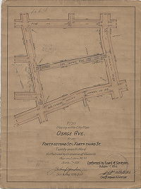
| 166-08 FLAT |
|
Plan placing Osage Ave. from Forty-second St. to Forty-third St., Twenty-seventh Ward [Ordinance June 30, 1910; confirmed Oct. 17, 1910] | Gillingham, J. Harvey | 1910 |
Mounted
15 x 11 in.
|
West Philadelphia
Curb elevations
|
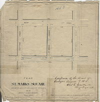
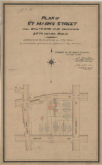
| 166-09 FLAT |
|
Plan of St. Mark's Square between Walnut and Locust Streets in the Twenty-seventh Ward, Philadelphia Ordinance Dec. 31, 1881; confirmed Aug. 7, 1882] | Jones, William H. | 1882 |
Paper
12 x 12 in.
|
West Philadelphia
Curb elevations
|
| 166-10 FLAT |
|
Plan striking from the City Plan Forty-fourth Street from Osage Avenue to Kingsessing Avenue, Twenty-seventh Ward [Ordinance June 3, 1904; confirmed Sept. 19, 1904] | Gillingham, J. Harvey | 1904 |
Mounted
16 x 10 in.
|
West Philadelphia
Curb elevations
|
| 166-11 FLAT |
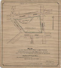
|
Plan of the placing on City Plan for park purposes a lot of ground in the 27th Ward, situate between 43rd & 44th Sts., Baltimore and Chester Aves., to be called Clarence H. Clark Park [Ordinance June 18, 1894; survey returned July 9, 1894; no confirmation noted] | Jones, William H. | 1894 |
Mounted
13 x 12 in.
1 inch = 100 feet
|
West Philadelphia
Clark Park
|
| 166-12 FLAT |

|
Plan of the revision of lines and grades of that portion of Plan No. 166 bounded by 43rd St., Chester Ave., 45th St. and Baltimore Ave., 27th Ward, Phila. [Ordinance Oct. 23, 1901; survey returned Jan. 2, 1902; confirmed Jan. 20, 1902] | Gillingham, J. Harvey | 1902 |
Mounted
17 x 14 in.
1 inch = 100 feet
|
West Philadelphia
Curb elevations
|
| 166-13 FLAT |

|
Plan of De-Lancey [now Delancey] St. 20 ft. wide from 41st St. to 40-1/4 St. and Forty and One-Quarter St. 20 ft. wide from De-Lancey St. to Pine St., 27th Ward, Phila. [Ordinance Dec. 23, 1895; survey returned Feb. 14, 1896; confirmed March 23, 1896] | Gillingham, J. Harvey | 1896 |
Mounted
15 x 13 in.
1 inch = 100 feet
|
West Philadelphia
Curb elevations, building footprints
|
| 166-14 FLAT |
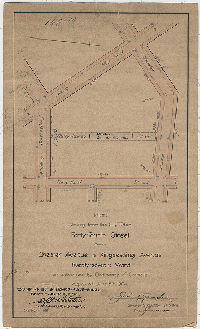
|
Plan of St. Marks Street from Baltimore Ave. southward, 27th Ward, Phil'a. [Ordinance July 9, 1897; confirmed Oct. 18, 1897] | Gillingham, J. Harvey | 1897 |
Mounted
19 x 12 in.
1 inch = 100 feet
|
West Philadelphia
Curb elevations, building footprints
|
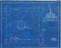
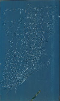
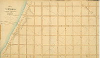
| 167-02 MTD |

|
Plan for placing on City Plan Cobbs Creek Park, Thirty-fourth Ward. [Ordinance July 7, 1908; confirmed May 3, 1909] | Johnson, Joseph | 1909 |
Mounted
42 x 65 in.
|
West Philadelphia, Cobbs Creek Park. Bounded by Haverford Ave. to Cobb's Creek, Lansdowne Ave. to 63rd St.
Topography, Cobb's Creek and tributary streams, including Indian Creek, building footprints, quarry, mill race, "lake"
|
| 167-03 MTD |
|
Plan of the Eleventh Section of the survey of the late Township of Blockley. [Acts of Assembly April 3, 1851 and May 13, 1856; survey returned June 6, 1859; confirmed by Board of Surveyors May 7, 1860; confirmed by Court Aug. 24, 1864] | Lightfoot, Francis | 1859 |
Mounted
42 x 41 in.
|
West Philadelphia, Blockley Township, 11th Section. Bounded by Cobb's Creek to Haverford Rd., 65th St. to Carter St.
Indian Creek, Cobb's Creek, property lines and property owners, building footprints.
|
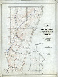
| 167-04 MTD |

|
Plan 167 to place on City Plan as a public park certain tracts of land in the Thirty-fourth Ward as additions to Cobb's Creek Park and Morris Park and to make the necessary revision of lines and grades of streets. [Ordinance Dec. 2, 1911; confirmed June 1, 1914] | Johnson, Joseph | 1914 |
Mounted
43 x 66 in.
|
West Philadelphia, Cobb's Creek Park and Morris Park. Bounded roughly by Cobb's Creek, Lansdowne Ave., Haverford Ave. and 53rd St.
Topography, drawing of Millbourne Mills, drawing of fishing man with his pole as north arrow, signpost scale, Indian Creek.
|
| 167-05 MTD |
|
Plan of the Eleventh Division of the survey and regulation of the late Township of Blockley [Resolution Dec. 31, 1875; survey returned Dec. 1877; no confirmation date] | Hancock, George W. | 1877 |
Mounted
57 x 54 in.
|
West Philadelphia, Blockley Township, 11th Division. Bounded roughly by Haverford and Haddington Aves. to Cobbs Creek, 65th St. to Sellers St.
Topography, Indian Creek, mill races, ponds, building footprints, quarries
|
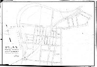
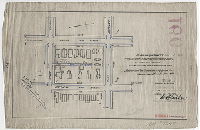
| 168-01 HP |
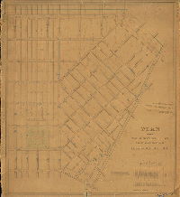
|
Plan of the Third Section of the survey and regulation of Kensington District approved by the Board of Commissioners May 17, 1852, revised and returned 1852, by James P. Davis. | Davis, James P. | 1852 |
Mounted
52 x 46 in.
1 inch = 100 feet
|
Kensington District, 3rd Section. Bounded by Norris St. to Lehigh Ave., 2nd St. to Frankford Ave.
Norris Square with delineation of paths, sewers, curb elevations
|
| 169-02 MTD |

|
Plan to place on the City Plan Coleman Street (70 feet wide) from 54th St. to 56th St. [Ordinance May 13, 1913; confirmed Aug. 4, 1913] | Johnson, Joseph | 1913 |
Mounted
16 x 23 in.
|
West Philadelphia. Bounded by Wynnefield Ave, 54th St., Susquehanna Ave. and 56th St.
Curb elevations
|
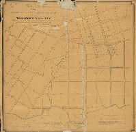
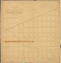
| 169-06 MTD |
|
Plan of the Thirteenth Section of the survey of the late Township of Blockley made in pursuance to two Acts of Assembly of the State of Pennsylvania approved respectively on the 3rd day of April A.D. 1851 and on the 13th day of May A.D. 1856. [Survey returned Dec. 7, 1859; approved May 7, 1860; confirmed by Court July 20, 1861] | Lightfoot, Francis | 1859 |
Mounted
44 x 43 in.
1 inch = 150 feet
|
West Philadelphia, Blockley, 13th Section. Bounded by Columbia Ave. to City Ave., 56th to 66th Sts.
Curb elevations, old roads, railroad
|
| 169-07 MTD tracing part1 |
|
First section - Plan of the Fourth Section of the revised survey and regulation of the Twenty-fourth Ward in the vicinity of Fairmount Park [Resolution Feb. 16, 1869; survey returned July 1,1876; confirmed April 9, 1877; tracing made in 1911] | Hancock, George W. | 1876 |
Tracing
63 x 52 in.
1 inch = 100 feet
|
West Philadelphia. Covers part of City Plan 169; adjoins 169-07_MTD_tracing_part2. Entire area bounded roughly by City Ave. to Oxford Ave., 66th to 53rd Sts.
Topography, Mill Creek and tributary streams, ponds, mill races, building footprints, railroad
|
| 169-07 MTD tracing part2 |
|
Second section - Plan of the Fourth Section of the revised survey and regulation of the Twenty-fourth Ward in the vicinity of Fairmount Park [Resolution Feb. 16, 1869; survey returned July 1,1876; confirmed April 9, 1877; tracing made in 1911] | Hancock, George W. | 1876 |
Tracing
63 x 48 in.
1 inch = 100 feet
|
West Philadelphia. Covers part of City Plan 169; adjoins 169-07_MTD_tracing_part1. Entire area bounded roughly by City Ave. to Oxford Ave., 66th to 53rd Sts.
Topography, Mill Creek and tributary streams, ponds, mill races, building footprints, railroad
|
| 169-15 MTD |
|
Plan to revise the lines and grades on the portion of City Plan No. 169 between Wynnefield Ave., Overbrook Ave., 54th St. and 57th St., and to change the name of 55th Street from Overbrook Ave. to City Ave., to 56th Street, and to change the name of 56th Street from Overbrook Ave. to City Ave., to Ithan Street. [Ordinance Nov. 28, 1914; confirmed May 3, 1915] | Not named | 1915 |
Mounted
28 x 40 in.
|
West Philadelphia. Bounded by City Ave. to Woodbine Ave., 54th to 57th Sts.
Topography
|
| 170 CP |
|
[No title. Topography on City Plan 170, Fairmount Park vicinity] | Not named | 1880 ca. |
Blueprint
71 x 42 in.
|
West Philadelphia. Bounded roughly by City Ave. to Columbia Ave., Bryn Mawr Ave. and Parkside Ave. to 54th St.
Topography, streams
|
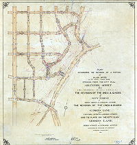
| 170-01 MTD |
|
Plan authorizing the revision of a portion of Plan No. 170 in the Thirty-fourth Ward striking from the City Plan Arlington Street from Fifty-second St. to Fifty-fourth St. The revision of the lines and grades of Fifty-third St. from Berks Street to Lebanon Avenue. The revision of the lines and grades of Georges Lane from Columbia Avenue to Berks Street and to place on the City Plan Georges Lane from Berks Street to Lebanon Avenue [Ordinance Jan. 30, 1913; confirmed Nov. 3, 1913 | Johnson, Joseph | 1913 |
Mounted
41 x 39 in.
|
West Philadelphia. Bounded by Susquehanna Ave., Parkside Ave. or George's Run, Columbia Ave. and 54th St.
Topography, stream (George's Run) above 52nd St. and Parkside Ave.
|
| 170-02 MTD |

|
Plan of the Eighth Section of the survey of the late Township of Blockley, made agreeably to the Acts of the General Assembly of the Commonwealth of Pennsylvania approved April 3rd, 1851 and May 13th, 1857. Surveyed under a contract made with the Blockley Commissioners by Samuel L. Smedley, City Surveyor & Regulator, 11th Dist., Philadelphia, Pa. Approved by the Board of Surveyors...March 3d, 1862. | Smedley, Samuel L. | 1859 |
Mounted
38 x 53 in.
|
West Philadelphia, Blockley Township, 8th Section. Bounded by Oxford St. to City Ave., 48th St., Belmont Estate, 51st and 56th Sts.
George's Run, "part of the Belmont Estate", "S. L. Smedley, Script."
|
| 170-05 MTD |

|
Plan of Park Side Avenue from Columbia Ave. to Bryn Mawr Ave. [Resolution Feb. 16, 1869; survey returned Jan. 20, 1896; confirmed April 6, 1896] | Johnson, Joseph | 1896 |
Mounted
22 x 27 in.
1 inch = 100 feet
|
West Philadelphia. Parkside Avenue from Bryn Mawr Ave. to Columbia Ave.
Curb elevations, railroad, George's Lake
|
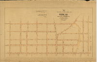
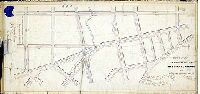
| 171-01 MTD |
|
Plan of the regulation of the Seventh Section of the Twenty-third Ward, Philadelphia, made in pursuance of a resolution of Councils of the City of Philadelphia passed Feby. 8th, 1858. [Approved by Board of Surveyors April 16, 1860] | Shallcross, Isaac | 1860 |
Mounted
50 x 45 in.
|
23rd Ward, 7th Section. Bounded by Germantown Ave. to 12th St., Erie Ave. to Cayuga St..
Railroad
|
| 171-39 MTD |

|
Plan of Camac Street [Ordinance June 21, 1878; confirmed Oct. 21, 1878] | Not named | 1878 |
Paper
19 x 8 in.
|
Bounded by Pike St., Old York Rd., Erie Ave. and 13th St.
Curb elevations
|
| 172-01 HP |
|
Plan of the Ninth Section of the survey and regulation of the Twenty-first Ward of the City of Philadelphia, Made in pursuance of an ordinance of the Select and Common Councils of the said City, approved Aug. 15th, 1855. | Siddall, Joseph S. | 1855 |
Mounted
33 x 58 in.
1 inch = 100 feet
|
21st Ward, 9th Section. Bounded by Columbia to Susquehanna Aves., 30th St. to Schuylkill River
Property owners, lines, benchmark building, sewers, streams, topographical shading, three actual streets, curb elevations. Plan predates Fairmount Park.
|