
Philadelphia Streets Department Surveys
2755 result(s). Showing results 701 to 750.
View page: 1 2 3 4 5 6 7 8 9 10 11 12 13 14 15 16 17 18 19 20 21 22 23 24 25 26 27 28 29 30 31 32 33 34 35 36 37 38 39 40 41 42 43 44 45 46 47 48 49 50 51 52 53 54 55 56 (Show all on one page)
| Identifer | Preview | Title | Surveyor | Date | Media / Size / Scale | Area / Map Features |
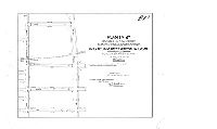
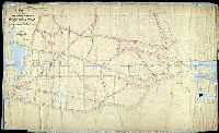
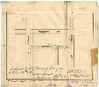
| 187-07 MTD |

|
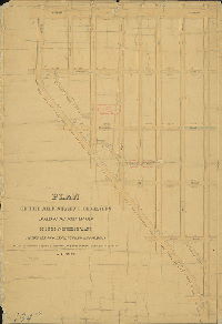
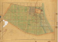
Plan of the revision of lines and grades of a portion of City Plan No. 187, Twenty-fifth Ward, Philadelphia [Ordinances 1890, 1896 and 1897; survey returned March 2, 1897; confirmed June 21, 1897] | Mercer, Joseph | 1897 |
Mounted
26 x 41 in.
|
25th Ward. Bounded by Frankford Ave., Frankford Creek, Sepviva St. and Erie Ave.
Frankford Creek, railroads
|
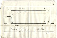
| 187-09 MTD |
|
Plan No. 187. Revision of lines and grades required to avoid grade crossings on the Philadelphia and Trenton Railroad from Butler St. to Erie Ave., Twenty-fifth Ward, Philadelphia [Ordinance Feb. 2, 1897; amended April 1, 1899; confirmed April 2, 1900] | Mercer, Joseph | 1900 |
Mounted
21 x 27 in.
|
Bounded by Coral St., Butler St., Tulip St. and Erie (Castor) Ave.
Curb elevations, railroad
|
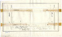
| 187-10 MTD |
|
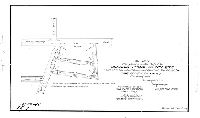
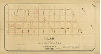
Plan for placing on the City Plan Arcadia, Coral and Vici Sts. north of Wheatsheaf Lane and east of Frankford Ave., Twenty-fifth Ward, Philadelphia Ordinance Feb. 2, 1897; confirmed May 3, 1897] | Mercer, Joseph | 1897 |
Mounted
12 x 19 in.
|
Several small streets near intersection of Frankford Ave. and Wheatsheaf Lane
Curb elevations
|
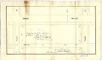
| 187-11 MTD |

|
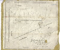
Plan of the revision of the lines of Frankford Creek from Frankford Ave. to a point 145 ft. northwest of P. and T. R.R. Bridge [Ordinance June 27, 1900; confirmed Nov. 19, 1900] | Mercer, Joseph | 1900 |
Mounted
14 x 16 in.
|
Frankford Creek near Frankford Ave.
Frankford Creek and Frankford Ave. realignment, railroad, old and new channel of creek
|
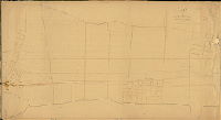
| 188-02 MTD tracing |

|
Plan of the revision of lines and grades of the First Section of the Twenty-fifth Ward, Philadelphia. [Ordinance Feb. 25, 1887; confirmed Feb. 3, 1890] | Webster, George S. | 1890 |
Tracing
61 x 40 in.
|
Bounded by Frankford Ave., Erie Ave., Richmond St. and Westmoreland St.
Topography, building footprints
|
| 188-04 CP |
|
[No title. Topography of City Plan 188] | Not named | 1888 ca. |
Tracing
43 x 72 in.
|
Bounded by Carbon St., Erie Ave., Frankford Ave. and Allegheny Ave.
Topography, sewers, building footprints
|
| 189-01 HP |

|
Plan of the 9th Section of the survey of the late Township of Blockley made agreeably to the Act of the General Assembly of the Commonwealth of Pennsylvania, approved Apr. 3rd 1851 and May 13, 1857, by Saml. L. Smedley [Survey returned Dec. 18, 1862; confirmation date not noted] | Smedley, Samuel L. | 1862 |
Mounted
62 x 34 in.
1 inch = 100 feet
|
West Philadelphia, Blockley Township, 9th Section. Susquehanna St. to City Ave., 51st St. to Belmont Ave.
Christ Church Hospital, Belmont boundary line
|
| 190-01 CP |
|
Plan showing streets, contours and property lines from City Av. to Park boundary | Not named | 1877 |
Tracing
52 x 43 in.
1 inch = 100 feet
|
West Philadelphia. Bounded by City Ave., Schuylkill River, Fairmount Park, Edgley Ave., and Windermere (39th) St.
Topography, streams, Simpson's Dam (mill pond), property lines and owners, original roads shown as dotted lines, Reading Railroad
|
| 190-01 MTD |

|
Plan of the Sixteenth Section of the survey of the late Township of Blockley made agreeably to the Acts of the General Assembly of the Commonwealth of Pennsylvania approved April 3rd, 1851, and May 13th, 1857. Surveyed by contract with the Board of Commissioners by Saml. L. Smedley, Sur. & Regulator, 11th Dist. Returned to the Board of Surveyors [date not noted; perhaps ca. 1862, as for 189-01_HP]. | Smedley, Samuel L. | 1862 ca. |
Mounted
49 x 54 in.
|
West Philadelphia, Blockley, 16th Section. Bounded by City Ave. and Belmont Estate, Schuylkill River to Belmont Ave.
Streams, valleys delineated with hachure marks, old roads, building footprints in pencil
|
| 190-02 CP |

|
Compiled plan of City Plan No. 190, 52nd Ward Philadelphia | Barton and Martin | 1968 |
Tracing
42 x 80 in.
1 inch = 100 feet
|
West Philadelphia. Bounded by City Ave., Schuylkill Expressway, Fairmount Park boundary, Edgley Ave., and Belmont Ave.
Topography, streams
|
| 190-02 MTD |
|
Plan of the Third Section of the revised survey and regulation of the Twenty-fourth Ward in the vicinity of Fairmount Park [Resolution Feb. 16, 1869; survey returned Nov. 22, 1881; confirmed May 1, 1882] | Johnson, Joseph | 1881 |
Mounted
88 x 54 in.
|
West Philadelphia. 24th Ward, 3rd Section. Bounded by City Ave., Schuylkill River, Midvale and Crestline Aves., and Belmont Ave.
Topography, streams
|
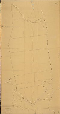
| 192-01 HP |
|
Plan of a portion of 23rd Ward lying between Bridesburg and Holmesburg east of Bristol Turnpike | Shallcross, Isaac | 1860 |
Mounted
87 x 47 in.
1 inch = 200 feet
|
23rd Ward. Bounded by Frankford & Bristol Turnpike to Delaware River, Bridge St. to Delaware Ave
Tacony Land Association, roads, streams
|
| 193-01 HP |
|
Plan of a portion of 23rd Ward lying between Pennypack Creek and Poquessing Creek east of Bristol Turnpike [Resolution July 13,1860 ; approved by Board of Surveyors Dec. 1, 1862; confirmed by Court May 18, 1863] | Shallcross, Isaac | 1862 |
Mounted
90 x 47 in.
1 inch = 200 feet
|
23rd Ward. Bounded by Delaware Ave. (Holmesburg) to Poquessing Creek, Frankford & Bristol Turnpike to Delaware River
Phila & Trenton Railroad, creeks, property owners in Torresdale
|
| 193-02 HP |
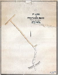
|
Plan of proposed road, Twenty-third Ward Philada. Isaac E. Shallcross. | Shallcross, Isaac | 1860 ca. |
Mounted
23 x 18 in.
|
23rd Ward, near Poquessing Creek
Poquessing Creek
|
| 194-01 MTD |

|
Plan of the adjustment of grades in part of the First Section of the Nineteenth Ward, agreeably to resolutions of Councils passed the twenty-eighth day of April and the twenty-ninth day of October A.D. 1860. | Not named | 1860 ca. |
Mounted
67 x 48 in.
|
19th Ward, 1st Section. Bounded roughly by Lehigh Ave., 6th St., Oxford Ave., Frankford Ave., Norris St., Front St. and Kensington Ave.
Curb elevations, sewers, Norris Square with paths
|
| 194-02 MTD |
|
Plan of the adjustment of grades in part of the First Section of the Nineteenth Ward, agreeably to resolutions of Councils passed the twenty-eighth day of April and the twenty-ninth day of October A.D. 1860. | Not named | 1860 ca. |
Mounted
32 x 22 in.
|
19th Ward, 1st Section. Triangle bounded by Germantown Ave., Lehigh Ave. and Sixth St.
Curb elevations, sewers
|
| 197-04 MTD |

|
Plan of the adjustment of grades in the Fourth Section of the Nineteenth Ward, agreeably to a resolution of Councils passed the twenty-eighth day of April A.D. 1860. [No confirmation date] | Not named | 1860 ca. |
Mounted
53 x 48 in.
|
19th Ward, 4th Section. Bounded by Pike St., Westmoreland St., Delaware River, and Richmond St.
Curb elevations, sewers, proposed canals
|
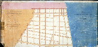
| 198 CP |
|
[No title. Topography of City Plan 198, and parts of Plans 214 and 16. This plan is a contiguous to 185_CP.] | Not named | 1885 ca. |
Tracing
40 x 138 in.
|
Bounded roughly by Chelten Ave., Wayne Ave., Washington Lane, Greene St., Wissahickon Creek, and Wissahickon Ave.
Topography, streams, mill ponds, dams, quarries, Wissahickon Creek
|
| 198-01 MTD |
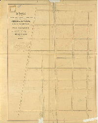
|
Plan of the Fourth Section of the resurvey and regulation of the late Borough of Germantown, Twenty-second Ward, City of Philadelphia. [Resolution April 1, 1856; approved by Board of Surveyors June 6, 1864; confirmed by Court March 29, 1866] | Lightfoot, Jesse | 1864 |
Mounted
52 x 41 in.
|
22nd Ward, 4th Section, Germantown. Bounded by Carpenter St. to Washington Lane, Wissahickon Ave. to Green St.
Topography over part of plan, streams, ponds
|
| 198-02 MTD |

|
Plan of the revision of the lines and grades upon the Fourth Section, Twenty-second Ward, Philadelphia [Ordinance Jan. 19, 1883; confirmed Sept. 28, 1885] | Stallman, H. A. | 1885 |
Mounted
33 x 46 in.
|
22nd Ward, 4th Section, Germantown.. Bounded by Carpenter St. to Washington Lane, Wissahickon Ave. to Green St.
Topography, streams, springs, Paper Mill Run (Monoshne Creek), Lincoln Drive
|
| 199-t HP |

|
[Handwritten on attached label: "Plan showing curb elevation, Section 300 to 312, 950 to 912. 199 tube" | Kneass, Samuel H. | 1840 |
Mounted
27 x 39 in.
1 inch = 300 feet
|
South Philadelphia. Bounded by South St. to McKean St., Delaware River to 11th St.
Moyamensing Prison, Navy Yard, canal basin, sewers, corner elevations, wharves, cemetery, list of culverts (sewers), Thomson vs. Kneass boundaries
|
| 199-u HP |

|
Plan exhibiting the curb heights watercourses and culverts in the southern section of Southwark [Act of Assembly June 21, 1839; approved by Commissioners Oct. 21, 1840; confirmed by Court Dec. 12, 1840] | Kneass, Samuel H. | 1840 |
Mounted
28 x 46 in.
1 inch = 160 feet
|
South Philadelphia. Bounded by Delaware River to 10th St., Washington Ave. to Canal below Moore St.,
Moyamensing Ave. Market at Federal St., sewers, curb elevations, footprints of buildings in Navy Yard
|
| 199-v HP |
|
Plan exhibiting the curb heights watercourses and culverts in the northern section of Southwark [Act of Assembly June 21, 1839; approved by Commissioners Oct. 21, 1840; confirmed by Court Dec. 12, 1840] | Kneass, Samuel H. | 1840 |
Mounted
22 x 45 in.
1 inch = 160 feet
|
South Philadelphia. Bounded by Delaware River to Passyunk Ave., Cedar to Prime Sts.
Shippen St. Market, sewers, curb elevations
|
| 199-w HP |
|
A plan of the streets in the district of Southwark, below Carpenter St., shewing the heights at which the curbs are to be placed . . By J. Edgar Thomason, civ. Engr. Oct. 1834. | Thomson, J. Edgar | 1834 |
Mounted
39 x 52 in.
1 inch = 166 feet
|
South Philadelphia, Southwark. Washington Ave. to south of Moore St., Delaware River to Passyunk Ave., west of 9th St.
Southwark Railroad, Union Cemetery (6th & Federal Sts.), rope walks, building footprints in old Navy Yard, sewers, wharves, marshland, watercourses
|
| 199-x HP |
|
Plan of the line & grade regulations, Section No. 2, First Ward [Survey returned 1864] | Young, Alfred | 1864 |
Mounted
38 x 75 in.
1 inch = 100 feet
|
South Philadelphia, 1st Ward. 2nd Section. Bounded by Mifflin to Wolf Sts., 5th St. to Delaware River
Building footprints, curb elevations, sewers, later annotations in red ink, buildings in street lines
|
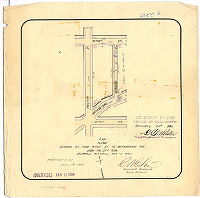
| 199-y HP |
|
Lines and grades of 4th Street from Jackson Street to Government Avenue [Confirmed June 2, 1890] | Not named | 1890 |
Mounted
12 x 106 in.
1 inch = 100 feet
|
South Philadelphia. Bounded by 4th to 5th Sts. Jackson St. to Government Lane
Grave-Hole Lane, curb elevations
|
| 199-z HP |

|
Plan of Southwark, Moyamensing and Passyunk extending from the Delaware to the Schuylkill River and from South Street to the Canal, exhibiting the grades and watercourses in each district | Kneass, Samuel H. | 1840 |
Mounted
27 x 82 in.
1 inch = 300 feet
|
South Philadelphia. Bounded by Delaware River to Schuylkill River, South St. to south of Moore St.
Moyamensing Prison, Navy Yard, Asylum, Arsenal, Delaware and Schuylkill Canal, proposed lock, property lines, tinted districts
|
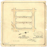
| 200-01 HP |

|
Plan of the line & grade regulations of a portion of the First Ward, Philadelphia, 1863, Section 7 [Ordinance May 10, 1862; survey returned and approved by Board of Surveyors Jan. 25, 1864; confirmed by Court March 22, 1864] | Young, Alfred | 1863 |
Mounted
48 x 56 in.
1 inch = 50 feet
|
,South Philadelphia, 1st Ward, 7th Section. Bounded by Morris to Porter Sts., 5th to Broad Sts.
Building footprints, some in streets, red ink street annotations through 1890s
|
| 200-02 HP |
|
[No title. Tree Street, off Seventh Street between Jackson St. and Moyamensing Ave. Ordinance Dec. 16, 1874; confirmed April 19, 1875] | Close, Charles S. | 1875 |
Paper
12 x 14 in.
|
South Philadelphia
Curb elevations
|
| 200-04 HP |
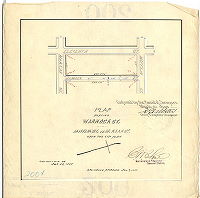
|
Plan placing Warnock St. from Jackson St. to McKean St. upon the City Plan. [Ordinance July 9, 1897; survey returned July 26, 1897; confirmed March 21, 1898] | Close, Charles W. | 1897 |
Paper
11 x 11 in.
|
South Philadelphia
Curb elevations
|
| 200-05 HP |
|
Plan placing Dean [now Iseminger] and Pallas [now Camac] Sts. from Ritner St. to Porter St. upon the City Plan. [Ordinance March 30, 1893; survey returned April 7, 1893; confirmed Nov. 19, 1894] | Close, Charles W. | 1893 |
Paper
11 x 11 in.
|
South Philadelphia
Curb elevations
|
| 200-06 HP |
|
Plan placing Gerhard [now Sartain] St. from Ritner St. to Moyamensing Ave. upon the City Plan. [Ordinance Nov. 13, 1895; survey returned Nov. 18, 1895; confirmed Jan. 20, 1896] | Close, Charles W. | 1895 |
Paper
11 x 11 in.
|
South Philadelphia
Curb elevations
|
| 200-07 HP |
|
Plan placing Fitzgerald St. from 12th St. to 13th St. on the City Plan. [Ordinance March 30, 1893; surveyed April 14, 1893; confirmed April 19,1894] | Close, Charles W. | 1893 |
Paper
11 x 11 in.
|
South Philadelphia
Curb elevations
|
| 200-08 HP |

|
Plan placing upon City Plan Darien Street from Wolf St. to Moyamensing Ave. [Ordinance May 19, 1896; surveyed May 25, 1896; confirmed June 29, 1896] | Close, Charles W. | 1896 |
Paper
11 x 11 in.
|
South Philadelphia
Curb elevations
|
| 200-09 HP |
|
[No title. Gerhard [Sartain] Street between Moore and Mifflin Sts. Ordinance July 2, 1889, survey returned March 27, 1890; confirmed Oct. 20, 1890] | Close, Charles S. | 1890 |
Paper
10 x 10 in.
|
South Philadelphia
Curb elevations
|
| 200-10 HP |
|
[No title. Pallas or Palas (now Camac) Street between McKean and Mifflin Sts. Survey returned April 1872; confirmed Dec. 1, 1873] | Close, Charles S. | 1872 |
Paper
11 x 16 in.
|
South Philadelphia
Curb elevations
|
| 200-11 HP |

|
[No title. Dean St. from Mifflin to McKean Sts. Ordinance April 27, 1872; confirmed Oct. 7, 1872] | Close, Charles S. | 1872 |
Paper
11 x 16 in.
|
South Philadelphia
Curb elevations
|
| 200-12 HP |
|
[No title. Gerhard (now Sartain) Street between Mifflin and McKean Streets. Ordinance Dec. 16, 1874; confirmed April 19, 1875] | Close, Charles S. | 1875 |
Paper
10 x 16 in.
|
South Philadelphia
Curb elevations
|
| 200-13 HP |
|
[No title. Cantrell Street between 7th and 8th Sts. Ordinance Nov. 17, 1877; survey returned Dec. 21, 1877; confirmed April 15, 1878] | Close, Charles S. | 1877 |
Paper
10 x 16 in.
|
South Philadelphia
Curb elevations
|
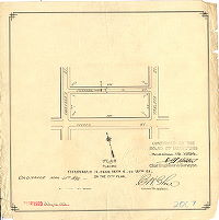
| 200-14 HP |
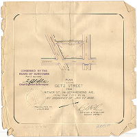
|
Plan placing Getz Street from Ritner St. to Moyamensing Ave. upon the City Plan [Ordinance Jan. 27, 1896; survey returned Jan. 29, 1896; confirmed April 20, 1896] | Close, Charles W. | 1896 |
Paper
11 x 11 in.
|
South Philadelphia
Curb elevations
|
| 200-15 HP |
|
[No title. Getzz [Getz or Jessup] St. between McKean and Mifflin Sts. Confirmed April 19, 1875] | Close, Charles S. | 1875 |
Paper
11 x 16 in.
|
South Philadelphia
Curb elevations
|
| 200-16 HP |
|
[No title. Mercy Street, Fifth to Sixth Streets. Ordinance Jan. 15, 1876; survey returned Dec. 9, 1876; confirmed Jan. 15, 1877] | Close, Charles S. | 1876 |
Paper
10 x 16 in.
|
South Philadelphia
Curb elevations
|
| 200-17 HP |
|
[No title. Mercy Street, Sixth to Seventh Street. Ordinance Dec. 6, 1874; confirmed April 19, 1875] | Close, Charles S. | 1875 |
Paper
10 x 16 in.
|
South Philadelphia
Curb elevations
|
| 200-18 HP |
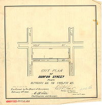
|
City Plan of Durfor Street from Eleventh St. to Twelfth St. [Ordinance June 23, 1893; survey returned June 30, 1893; confirmed Feb. 5, 1894] | Close, Charles W. | 1875 |
Paper
11 x 11 in.
|
South Philadelphia
Curb elevations
|
| 200-19 HP |

|
Plan for placing Watts, Juniper and Clarion Sts. from Ritner to Porter Sts. on the City Plan. Phila. [Ordinance March 30, 1893; confirmed Feb. 5, 1894] | Close, Charles W. | 1894 |
Paper
11 x 11 in.
|
South Philadelphia
Curb elevations
|
| 200-20 HP |

|
Plan placing upon the City Plan Winton Street from Fifth St. to Sixth St. Ordinance June 27, 1895; survey returned July 22, 1895; confirmed Sept. 16, 1895] | Close, Charles W. | 1895 |
Paper
11 x 11 in.
|
South Philadelphia
Curb elevations
|
| 200-21 HP |

|
Plan placing Farrell St. & Alder St. from Wolf St. to Ritner St. upon the City Plan. [Ordinance June 27, 1895; survey returned July 24, 1895; confirmed Sept. 16, 1895] | Close, Charles W. | 1895 |
Paper
11 x 11 in.
|
South Philadelphia
Curb elevations
|
| 200-22 HP |

|
Plan placing upon the City Plan McClellan Street from Ninth St. to Tenth St. [Ordinance April 3, 1900; survey returned April 16, 1900; confirmed July 16, 1900] | Close, Charles W. | 1900 |
Paper
11 x 11 in.
|
South Philadelphia
Curb elevations
|
| 200-23 HP |
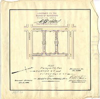
|
Plan placing on City Plan Durfor St. and Fitzgerald St. from Seventh St. to Marshall St. [Ordinance June 2, 1898; survey returned Aug. 15, 1898; confirmed Sept. 19, 1898] | Close, Charles W. | 1898 |
Paper
11 x 11 in.
|
South Philadelphia
Curb elevations
|
| 200-24 HP |

|
Plan placing Dean St., Snyder Av. to Jackson St. on the City Plan. [Survey returned Jan. 30, 1894; confirmed June 4,1894] | Close, Charles W. | 1894 |
Paper
11 x 11 in.
|
South Philadelphia
Curb elevations
|