
Philadelphia Streets Department Surveys
2755 result(s). Showing results 951 to 1000.
View page: 1 2 3 4 5 6 7 8 9 10 11 12 13 14 15 16 17 18 19 20 21 22 23 24 25 26 27 28 29 30 31 32 33 34 35 36 37 38 39 40 41 42 43 44 45 46 47 48 49 50 51 52 53 54 55 56 (Show all on one page)
| Identifer | Preview | Title | Surveyor | Date | Media / Size / Scale | Area / Map Features |
| 241-y HP |
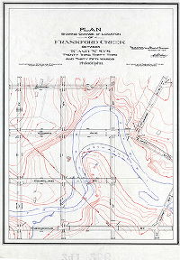
|
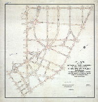
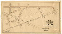
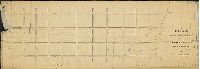
Plan showing change of location of Frankford Creek between 'K' and 'N' Sts. Twenty-third, Thirty-third and Thirty-fifth Wards, Philadelphia. [Ordinance April 4, 1894; survey returned Sept. 24, 1894; rejected by Board of Surveyors Nov. 28, 1894] | Webster, George S. | 1894 |
Tracing
34 x 24 in.
|
Frankford Creek, between Louden and Wingohocking Sts., K St. and N St.
Topography, Frankford Creek. Shows proposed shortening of horseshoe bend that necessitated two bridges over the Creek along the lines of Wyoming Avenue. Plan was rejected.
|
| 242-01 MTD |
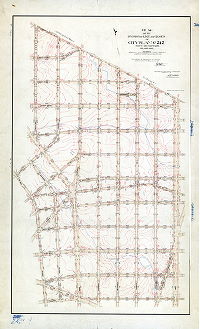
|
Plan of the revision of lines and grades of City Plan No. 242, Forty- second Ward Philadelphia, bounded by Broad St., Cheltenham Ave., Twenty-first St., Limekiln Turnpike and Chelten Ave. [Ordinances 1892, 1901 and 1907; confirmed March 21, 1910] | Wagner, Joseph C. | 1910 |
Mounted
77 x 48 in.
|
Bounded by Broad St., Cheltenham Ave., 21st St., Limekiln Turnpike and Chelten Ave.
Topography, streams
|
| 242-02 MTD |

|
Plan of the Seventeenth Section of the Survey and Regulation of the late township of Bristol, Twenty-second Ward, City of Philadelphia [Resolution March 16, 1870; survey returned Feb. 23, 1871; approved by Board of Surveyors May 1, 1871; confirmed by Court May 15, 1870] | Lightfoot, Jesse | 1871 |
Mounted
72 x 40 in.
|
22nd Ward, 17th Section, Bristol. Bounded by Broad St. to 21st St., Cheltenham Ave. to Chelten Ave.
Streams, ponds, curb elevations, building footprints
|
| 243-01 MTD |

|
[No title. Topography of City Plan 243] | Kronauer, M | 1890 |
Mounted
44 x 49 in.
|
Bounded by Broad St. to 21st St., Chelten Ave. to Chew St.
Topography (contours and spot elevations), building footprints (with corner elevations), green shading possibly denoting woodland, streams, springs, mill races, ponds, bridges, driveways, fences, old roads, property lines. Inscription: "Topography by M. Kronauer. Rec'd at Survey Bureau Oct. 25, 1890 ... Test levels taken & proved Nov. 7, 1890 by A. E. Harvey"
|
| 243-02 MTD |

|
Plan of the revision of lines and grades of that portion of City Plan No. 243, 42nd Ward, Philadelphia, bounded by Broad St., the line of Chew St., Stenton Ave., Church Lane and Spencer Ave., and to lay out on said plan such parkways, parking places and parks as may best preserve the natural beauties of the land within said boundaries. [Ordinance Dec. 1, 1911; confirmed Feb. 15, 1915] | Wagner, Joseph C. | 1915 |
Mounted
43 x 48 in.
1 inch = 100 feet
|
Bounded roughly by Church Lane, Broad St. Olney Ave. and Wister St. (formerly Stenton Ave.)
Topography, streams, Kemble Park, Harper's Hollow Park, playgrounds
|
| 243-03 MTD |
|
Plan of the Twelfth Section of the survey and regulation of the late Township of Bristol, Twenty-second Ward, City of Philadelphia [Resolution March 16, 1870, approved by Board of Surveyors April 17, 1871; confirmed by Court May 15, 1871] | Lightfoot, Jesse | 1871 |
Mounted
|
22nd Ward, 12th Section, Bristol. Bounded by Broad St., Chew St., Stenton Ave. and Chelten Ave.
Curb elevations, streams, ponds, springs, sewers, building footprints
|
| 243-04 MTD tracing |

|
Plan of revision of lines and grades of City Plan No. 243, Forty-second Ward Philadelphia, bounded by Broad St., Chew St., Stenton Ave. and Chelten Ave., and to place upon the City Plan Ogontz Avenue from Chew St. to Chelten Ave. [Ordinances 1892 and 1901; confirmed May 18, 1908] | Wagner, Joseph C. | 1908 |
Tracing
52 x 49 in.
|
Bounded by Broad St., Chew St., Stenton Ave. and Chelten Ave.
Topography, streams
|
| 243-05 MTD |

|
Plan of the extension of Broad Street [Confirmed by Court Feb. 15, 1871] | Not named | 1871 ca. |
Mounted
22 x 99 in.
|
Broad Street. From Chew St. to Township Line Rd. (now Stenton Ave.)
Curb elevations, building footprints marked H (for house?) and B (for barn?), old roads including Cheltenham and Willow Grow Turnpike, Limekiln Turnpike, and Green Lane
|
| 244-01 MTD |
|
Plan of the Thirteenth Section of the survey and regulation of the late Township of Bristol, Twenty-second Ward, City of Philadelphia [Resolution March 16, 1870; survey returned Feb. 18, 1871; approved by Board of Surveyors April [?], 1871; confirmed by Court May 15, 1871] | Not named | 1871 |
Mounted
79 x 47 in.
|
22nd Ward, 13th Section, Bristol, Bounded by Cheltenham Ave., 21st St., Limekiln Pike, Stenton Ave., and Washington La.
Streams, ponds, springs, sewers, curb elevations
|
| 244-02 MTD |
|
Plan of the revision of lines and grades of that portion of City Plan No. 244 bounded by Washington Lane, Limekiln Turnpike, Chelten Avenue and Stenton Avenue, Forty-second Ward Philadelphia. [Ordinance Feb. 15, 1909; confirmed Sept. 11, 1911] | Wagner, Joseph C. | 1911 |
Mounted
53 x 51 in.
|
Bounded by Washington Lane, Limekiln Turnpike, Chelten Ave. and Stenton Ave.
Topography, streams
|
| 244-03 MTD tracing |

|
Plan of the revision of lines and grades of that portion of City Plan No. 244, bounded by Twenty-first St., Cheltenham Ave., Washington Lane and Limekiln Turnpike. Forty-second Ward, Philadelphia [Ordinances 1901 and 1907; confirmed Jan. 17, 1910] | Wagner, Joseph C. | 1910 |
Tracing
53 x 31 in.
|
Bounded by 21st St., Cheltenham Ave., Washington Lane and Limekiln Turnpike
Topography, streams
|
| 245-01 HP |
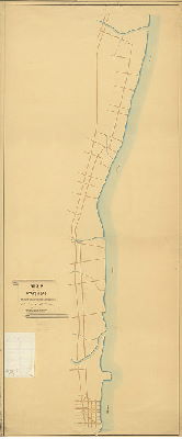
|
Map of the State Road in Philadelphia and Bucks Counties prepared In accordance with an Act of the Legislature of the State of Pennsylvania 6th April 1870 | Not named | 1870 |
Mounted
118 x 49 in.
1 inch = 400 feet
|
Philadelphia and Bucks Counties, State Road. Bounded by Washington [Disston] St. to Neshaminy Creek; Delaware River to Philadelphia & Trenton Railroad
Neshaminy, Pennepack (Pennypack) and Poquessink (Poquessing) creeks, roads, some property owners, one building ; metes and distances of road. Text of aauthorizing Act of Assembly on attached sheet.
|
| 245-x HP |
|
[No title. Detail of State Rd. from Wissinoming Creek to Township Line Rd. (now Cottman Ave.)] | Smedley, Samuel L. | 1872 |
Paper
10 x 22 in.
1 inch = 400 feet
|
Northeast Philadelphia. Bounded by Wissinoming Creek to Township Line Rd. [Cottman Ave.], Delaware River to Philadelphia and Trenton Railroad
Creeks, roads, property owners around Lardner's Point
|
| 245-y HP |

|
Plan of part of State Road, Twenty-third Ward Philadelphia. Prepared in accordance with an Act of the Legislature approved March 23rd, 1871. | Not named | 1871 ca. |
Mounted
29 x 68 in.
1 inch = 100 feet
|
23rd Ward, State Road. Bounded by Wissinoming Creek to Franklin St, Delaware River to Philadelphia and Trenton Railroad
Creeks, roads, some property owners,
|
| 246-01 FLAT |
|
Plan of 48-1/4 Street from grays Ferry Ave. to Paschall Avenue in the 27th Ward Philada. [Ordinance Dec. 9, 1778; survey returned Jan. 27, 1890; confirmed Sept. 15, 1890] | Jones, William H. | 1890 |
Paper
12 x 11 in.
|
West Philadelphia
Curb elevations, building footprints
|
| 246-01 MTD |

|
Plan of the Fourth Section of the survey and regulation of Kingsessing in the Twenty-fourth Ward [Resolution Nov. ?, 1858; Approved by Board of Surveyors Dec. 19, 1870; confirmed by Court May 15, 1871] | Not named | 1870 |
Mounted
40 x 62 in.
1 inch = 100 feet
|
Kingsessing, 4th Section. Bounded by Darby (now Woodland) Ave., Mill Creek or 43rd St., Schuylkill River and 56th St.
Mill Creek, unnamed stream, sewers, railroad
|
| 246-02 FLAT |
|
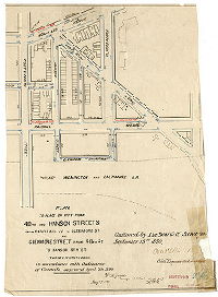
Plan of Hanson Street from Woodland Ave. to Paschall Ave. and Say Street from Hanson St. to 50th St. 27th Ward, Philadelphia. [Ordinance Nov. 25,1884; confirmed April 20, 1885] | Jones, William H. | 1885 |
Paper
12 x 14 in.
|
West Philadelphia
Curb elevations
|
| 246-03 FLAT |

|
Linmore Street as authorized to be placed on the City Plan from Forty-sixth to Forty-seventh Street, 27th Ward, Philad'a. by ordinance approved Nov. 12th, 1890 [Survey returned Dec. 11, 1890; confirmed March 2, 1891] | Jones, William H. | 1890 |
Paper
19 x 10 in.
|
West Philadelphia
Curb elevations, building footprints, railroad
|
| 246-04 FLAT |

|
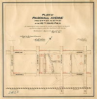
Plan of Paschall Avenue from 45-1/2 to 46th St. in the 27th Ward Philadelphia [Ordinance March 30, 1889; confirmed June 3, 1889] [AND] Plan of Saybrook St. from 45-1/2 St. to 46th St., and 45-1/2 St. from Saybrook St. to Paschall Ave. in the 27th Ward Philad'a. [Ordinance Sept. 25, 1888; survey returned Dec. 3, 1888; confirmed May 20, 1889] | Jones, William H. | 1888 |
Paper
19 x 11 in.
|
West Philadelphia
Curb elevations, building footprints, railroad
|
| 246-05 FLAT |
|
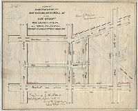
Plan to place on City Plan 48th and Hanson Streets from Paschall Av. To Glenmore St. and Glenmore St. from 48th St. to Hanson St., Twenty-seventh Ward [Ordinance April 7, 1890, survey returned May 27, 1890; confirmed Sept. 15, 1890] | Jones, William H. | 1890 |
Paper
17 x 12 (irregular) in.
|
West Philadelphia
Curb elevations, building footprints
|
| 246-05 MTD |
|
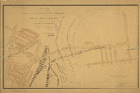
Plan of the revision of lines and grades of Grays Ferry Avenue and cross streets affected. 27th and 36th Wards, Philadelphia [Ordinance April 6, 1897; survey returned and plan confirmed July 19, 1917] | Daly, Thomas and Gillingham, J. Harvey | 1897 |
Mounted
30 x 47 in.
1 inch = 100 feet
|
Schuylkill River, Grays Ferry Avenue crossing, from 34th St. in South Philadelphia to Woodland Ave. in West Philadelphia
Existing and planned Gray's Ferry Avenue bridges; Philadelphia, Wilmington and Baltimore Railroad and engine house; Philadelphia Traction Co. depot; slaughterhous, restaurant, neighborhoods on both sides of the Schuylkill River, building footprints, Gray's Ferry Chemical Works
|
| 246-06 MTD |

|
Plan of the revision of lines and grades of that portion of Plan No. 246 between Forty-seventh and Forty-second St, Woodland Ave. and the Schuylkill River in the Twenty-seventh Ward, Philadelphia [Ordinance Dec. 16, 1890; survey returned Nov. 1, 1892; confirmed March 20, 1899] | Gillingham, J. Harvey | 1892 |
Mounted
27 x 26 in.
|
West Philadelphia. Bounded by 42nd to 47th Sts., Woodland Ave. to Schuylkill River
Mill Creek sewer, building footprints, property lines, railroads
|
| 246-07 FLAT |

|
46-1/2 Street as authorized to be placed on the City Plan from Woodland Ave. to Linmore t., 27th Ward, Philada. [Ordinance Feb. 26, 1891; confirmed April 20, 1891] | Jones, William H. | 1891 |
Paper
16 x 9 in.
|
West Philadelphia
Curb elevations, building footprints
|
| 246-07 MTD |
|
Plan of Paschall Avenue from 54th St. to 57th St. in the 40th Ward, Phil'a., as authorized to be reduced in width from 80 feet to 60 feet by taking 20 feet from the Southeast side thereof [Ordinances Sept. 12, 1892 and Nov. 15, 1898; survey returned Nov. 1898; confirmed July 17, 1899] | Gillingham, J. Harvey | 1898 |
Mounted
23 x 23 in.
1 inch = 100 feet
|
West Philadelphia. Bounded by 54th to 57th Sts., Woodland Ave. to Paschall Ave.
Building footprints, old roads, railroads
|
| 246-08 FLAT |

|
46-3/4 Street as authorized to be placed on the City Plan from Woodland Av. To Linmore Street, 27th Ward Phila. [Ordinance Dec. 20, 1892; survey returned Feb. 8, 1893; confirmed April 2, 1894] | Jones, William H. | 1893 |
Paper
13 x 13 in.
|
West Philadelphia
Curb elevations, building footprints
|
| 246-08 MTD |
|
Plan of the revision of lines and grades on that portion of Plan No. 246 bounded by Grays Ave., 49th St., Chester Branch of the P. & R. R.R., and 54th St., 40th Ward [Ordinance March 12, 1901; survey returned May 3, 1901; confirmed Nov. 18, 1901] | Gillingham, J. Harvey | 1901 |
Mounted
19 x 35 in.
1 inch = 100 feet
|
West Philadelphia. Bounded by Grays Ave., 49th St., Chester Branch of the Philadelphia and Reading Railroad, and 54th St.
Curb elevations, railroads
|
| 246-09 MTD |

|
Plan of Vogdes St. from Woodland Ave. to Paschall Ave. and Saybrook St. from 55th St. to Vogdes St., 40th Ward, Phil's. [Ordinance June 2, 1898; survey returned July 11, 1898; confirmed Oct. 17, 1898] | Gillingham, J. Harvey | 1898 |
Mounted
20 x 12 in.
1 inch = 100 feet
|
West Philadelphia. Bounded by Woodland Ave. to Paschall Ave., 55th to 56th Sts.
Curb elevations, building footprints, old road
|
| 246-10 MTD |
|
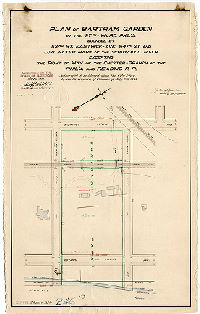
Plan of Bartram Garden in the 27th Ward, Phil'a. [Ordinance July 2, 1888; confirmed May 11, 1896] | Gillingham, J. Harvey | 1896 |
Mounted
23 x 15 in.
1 inch = 100 feet
|
West Philadelphia. Bounded by 53rd St, Eastwick Ave., 54th St., and the Schuylkill River
Curb elevations, Bartram's Garden, building footprints including Bartram house and outbuildings and Eastwick mansion, railroads, low water line and bulkhead line, large rock at riverfront
|
| 246-11 MTD |
|
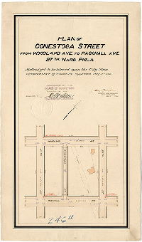
Plan of Conestoga Street from Woodland Ave. to Paschall Ave., 27th Ward, Phila. [Ordinance July 9, 18907; survey returned July 1897; confirmed Dec. 6, 1897] | Gillingham, J. Harvey | 1897 |
Mounted
20 x 12 in.
1 inch = 100 feet
|
West Philadelphia. Bounded by 54th to 55th Sts., Woodland to Paschall Aves.
Curb elevations, building footprints, Eastwick's Lane
|
| 246-12 CP |

|
Plan of the revision of the lines and grades upon Plan No. 246, the lines of which are crossed by the Baltimore and Philadelphia Railroad in the Twenty-seventh Ward of the City of Philadelphia [Ordinance July 3, 1885; confirmed April 18, 1887] | Not named | 1887 |
Tracing
53 x 68 in.
|
West Philadelphia. Bounded by Woodland Ave. to Schuylkill River, 42nd to 56thSts.
Topography, mouth of Mill Creek
|
| 246-12 MTD |
|
Plan placing on City Plan Linmore Street from Fifty-fourth to Fifty-fifth St. in the Fortieth Ward Philadelphia [Ordinance Jan. 15, 1906; survey returned Feb. 13, 1906; rejected by Board of Surveyors April 18, 1910] | Gillingham, J. Harvey | 1906 |
Mounted
13 X 11 in.
1 inch = 100 feet
|
West Philadelphia. Bounded by 54th to 55th Sts., Paschall Ave. to Philadelphia, Baltimore and Washington Railroad
Curb elevations, railroad, Eastwick's Lane
|
| 246-13 MTD |

|
Plan placing on City Plan Yewdall Street from Woodland Ave. to Paschall Ave., Fortieth Ward [Ordinance July 7, 1908; survey returned 1908; confirmed Dec. 6, 1909] | Gillingham, J. Harvey | 1908 |
Mounted
14 X 9 in.
1 inch = 100 feet
|
West Philadelphia. Bounded by 54th to 55th Sts., Woodland to Paschall Aves.
Curb elevations
|
| 246-14 MTD |
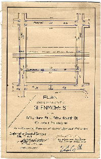
|
Plan placing on the City Plan Glenmore St. from Fifty-third St. to Fifty-fourth St., 40th Ward Philadelphia [Ordinance Feb. 13, 1905; survey returned March 17, 1905; confirmed May 1, 1905] | Gillingham, J. Harvey | 1905 |
Mounted
14 x 9 in.
1 inch = 100 feet
|
West Philadelphia. Bounded by 53rd to 54th Sts., Paschall Ave. to Grays Ave.
Curb elevations, railroad
|
| 246-15 MTD |

|
Plan placing on City Plan Fifty-sixth Street from Paschall Ave. to Linmore sty. and Linmore Street from Fifty-fifth St. to Fifty-sixth St. [Ordinance Feb. 27, 1905; survey returned June 22, 1905; confirmed Aug. 21, 1905] | Gillingham, J. Harvey | 1905 |
Mounted
13 x 10 in.
1 inch = 100 feet
|
West Philadelphia. Bounded by 55th to 56th Sts., Paschall Ave. to railroad
Curb elevations, railroad
|
| 246-16 MTD |
|
Plan placing upon City Plan Paxon Street from Woodland Ave. to Paschall Ave., 27th Ward, Philada. [Ordinance Jan. 17, 1898; survey returned March 7, 1898; rejected by Board of Surveyors April 18, 1910] | Gillingham, J. Harvey | 1898 |
Mounted
14 x 9 in.
1 inch = 100 feet
|
West Philadelphia. Bounded by 51st to 52nd Sts., Paschall Ave. to Woodland Ave.
Curb elevations
|
| 247-01 MTD |

|
Plan of the Fifth Section of the survey and regulation of Kingsessing, Twenty-fourth Ward [Resolution Nov. 1, 1858; approved by Board of Surveyors Dec. 19, 1870; confirmed by Court March 15, 1871] | Not named | 1870 |
Mounted
56 x 53 in.
|
Kingsessing, 5th Section. Bounded by Darby (now Woodland) Ave. to Botanic Ave., 56th to 63rd Sts.
Streams, marsh "flats", sewers, old road (Hay Lane). Green tint may indicate meadow land
|
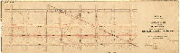
| 247-02 CP |

|
Plan of the revision of lines and grades with topography upon the streets of Plan No. 247 in the Twenty-seventh Ward Philadelphia [Ordinance Dec. 24, 1887; survey returned Jan. 21, 1889; confirmed 1889 to 1892] | Jones, William H. | 1889 |
Tracing
54 x 53 in.
1 inch = 100 feet
|
West Philadelphia. Bounded by Woodland Ave. to Botanic Ave., 56th to 63rd Sts.
Topography, streams and springs, building footprints, factories and refineries, Baltimore and Philadelphia Railroad and roundhouse, other railroads.
|
| 247-05 MTD |

|
Plan of Saybrook St. from Sixtieth St. to Sixty-second St. in the Fortieth Ward, Philadelphia [Ordinance June 28, 1899; survey returned and confirmed Sept. 11, 1899] | Gillingham, J. Harvey | 1899 |
Mounted
22 x 17 in.
1 inch = 100 feet
|
West Philadelphia. Bounded by Woodland to Grays Aves, 60th to 62nd Sts.
Curb elevations, railroad
|
| 247-06 MTD |
|
Plan of the revision of the lines and grades of the streets upon Plan No. 247, the lines of which are crossed by the Baltimore and Philadelphia railroad in the Twenty-seventh Ward, Philadelphia [Ordinance July 3, 1885; survey returned July 15, 1886; confirmed Feb. 21. 1887] | Jones, William H. | 1886 |
Mounted
18 x 57 in.
1 inch = 100 feet
|
West Philadelphia. Bounded by Woodland Ave. to Grays' Ave., 56th to 62nd Sts.
Topography, five-foot contours with some intermediate lines, streams and culverts, building footprints, railroads and turntable, old road (Hay Lane)
|
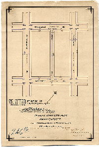
| 247-07 MTD |

|
Plan of Glenmore St. from 61st St. to 62nd St., Sixty-first St. from Grays Av. to Glenmore St., 40th Ward, Phil'a., as authorized to be placed upon the City Plan by ordinance of Councils Dec. 20th 1898 [Survey returned Jan. 3, 1899; confirmed April 24, 1899] | Gillingham, J. Harvey | 1899 |
Mounted
23 x 12 in.
1 inch = 100 feet
|
West Philadelphia
Curb elevations, building footprints, railroad
|
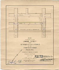
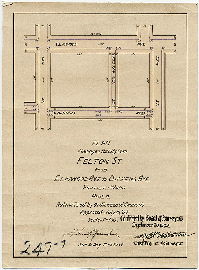
| 247-08 MTD |
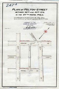
|
Plan of Felton Street between 62nd and 63rd Sts. In the 27th Ward, Phil'a., as authorized to be placed upon the City Plan by ordinance of Councils April 13th 1896 [Survey returned May 4, 1896; confirmed June 29, 1896] | Gillingham, J. Harvey | 1896 |
Mounted
18 x 12 in.
1 inch = 100 feet
|
West Philadelphia
Curb elevations
|
| 247-09 MTD |
|
Plan placing on the City Plan Felton St. from Elmwood Ave. to Dickens Ave. [Ordinance July 16, 1909; confirmed Sept. 20, 1909] | Gillingham, J. Harvey | 1909 |
Mounted
12 x 9 in.
1 inch = 100 feet
|
West Philadelphia
Curb elevations
|
| 247-10 MTD |
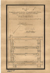
|
Plan of Reedland and Wheeler Sts., from 61st to 62d Street, Fortieth Ward, Philadelphia [Ordinance Feb. 10, 1899; survey returned Feb. 24, 1899; confirmed April 24, 1899] | Gillingham, J. Harvey | 1899 |
Mounted
17 x 10 in.
1 inch = 100 feet
|
West Philadelphia
Curb elevations
|
| 247-11 MTD |
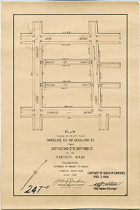
|
Plan placing on the City Plan Wheeler St. and Reedland St. from Sixty-second St. to Sixty-third St. in the Fortieth Ward Philadelphia. [Ordinance Jan. 15, 1906; survey returned Feb. 13, 1906; confirmed April 2, 1906] | Gillingham, J. Harvey | 1906 |
Mounted
16 x 10 in.
1 inch = 100 feet
|
West Philadelphia
Curb elevations
|
| 247-12 MTD |

|
Plan placing on the City Plan Glenmore St. from 62nd St. to 63rd St., 40th Ward, as authorized to be placed upon the City Plan by ordinance approved June 11, 1903 [Survey returned July 27, 1903; confirmed Feb. 21, 1910] | Gillingham, J. Harvey | 1903 |
Mounted
11 x 14 in.
1 inch = 100 feet
|
West Philadelphia
Curb elevations, building footprints, railroad
|
| 247-13 MTD |
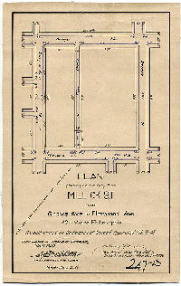
|
Plan placing on the City Plan Millick Street from Grays Ave. to Elmwood Ave., 40th Ward Philadelphia [Ordinance Feb. 13, 1905; survey returned March 17, 1905; confirmed May 1, 1905] | Gillingham, J. Harvey | 1905 |
Mounted
14 x 9 in.
1 inch = 100 feet
|
West Philadelphia. Bounded by Grays to Elmwood Aves., 60th to 61st Sts.
Curb elevations
|
| 248-01 MTD |
|
Plan of the Sixth Section of the survey and regulation of Kingsessing in the Twenty-fourth Ward [Resolution Nov. 1, 1858; approved by Board of Surveyors Dec. 19, 1870; confirmed by Court May 15, 1871] | Not named | 1870 |
Mounted
26 x 74 in.
|
Southwest Philadelphia. Bounded by Elmwood Ave. to Darby Ave., Island Ave. to 63rd St.
Curb elevations, railroad
|
| 248-03 MTD small |

|
Plan of the revision of lines and grades of a portion of Plan No. 248, from Woodland Ave. to Paschall Ave. between Seventy-first and Lloyd Streets, Twenty-seventh Ward, Philadelphia [Ordinance June 29, 1893; confirmed April 16, 1894] | Jones, William H. | 1894 |
Mounted
26 x 17 in.
1 inch = 100 feet
|
Southwest Philadelphia, Bounded by Woodland Ave. to Paschall Ave., 71st St. to Lloyd St.
Curb elevations, building footprints and lot lines, railroad, old road (Grovers Lane)
|
| 248-03 MTD tracing |
|
Plan of the revision of lines and grades with topography upon the streets of Plan No. 248 in the Twenty-seventh Ward Philadelphia. [Ordinance March 15, 1887; confirmed Oct. 3, 1892] | Not named | 1892 |
Tracing
74 x 30 in.
|
West Philadelphia. Bounded by Island Ave. to 63rd St., Woodland Ave. to Buist Ave.
Topography, building footprints, railroad
|
| 248-04 MTD |
|
Plan of the revision of grades upon that portion of Plan No. 248 bounded by Woodland Ave., P.W. & B. R.R., Sixty-third St. and Sixty-fifth St., 40th Ward Phila. [Ordinance Nov. 27, 1899; survey returned Jan. 1900; confirmed Feb. 5, 1900] | Gillingham, J. Harvey | 1900 |
Mounted
16 x 24 in.
1 inch = 100 feet
|
Southwest Philadelphia, Bounded by Woodland Ave. to Philadelphia, Wilmington and Baltimore Railroad, 63rd to 65th Sts.
Curb elevations, building footprints, railroad,
|