
Philadelphia Streets Department Surveys
2755 result(s). Showing results 1151 to 1200.
View page: 1 2 3 4 5 6 7 8 9 10 11 12 13 14 15 16 17 18 19 20 21 22 23 24 25 26 27 28 29 30 31 32 33 34 35 36 37 38 39 40 41 42 43 44 45 46 47 48 49 50 51 52 53 54 55 56 (Show all on one page)
| Identifer | Preview | Title | Surveyor | Date | Media / Size / Scale | Area / Map Features |
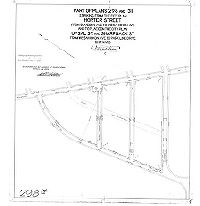
| 294-03 HP |

|
Plan of the revision of lines and grades on a portion of City Plan No. 294. Thirty-fifth Ward. Philadelphia. [Ordinances Sept. 21, 1887 and April 4, 1904; confirmed May 1, 1905] | Webster, Clement B. | 1905 |
Mounted
20 x 44 in.
|
Northeast Philadelphia. Bounded by Cottman to Borbeck Aves., G St. to Rising Sun Ave.
Topography, building footprints. On reverse: "Plan of New York Short Line Railroad revision"
|
| 294-04 HP |
|
Plan revising the grades of Rhawn St. between "G" & "I" Sts. on City Plan #294, 35th Ward Philadelphia [Ordinance Oct. 25, 1893; survey returned Jan. 16, 1894; confirmed April 2, 1894] | Webster, John H., Jr. | 1894 |
Mounted
22 x 17 in.
|
Northeast Philadelphia. Bounded by Stanwood to Loney Sts., G St. to I St.
Topography, building footprints
|
| 294-05 HP |
|
Plan revising the grades of Rhawn Street from "E" St. to Pine Road, Twenty-third Ward, Philadelphia. [Ordinance July 2, 1890; confirmed Oct. 20, 1890] | Webster, George S. | 1890 |
Mounted
24 x 17 in.
|
Bounded by Stanwood to Loney Sts., E (Ridgeway) St. to Oxford Rd. and Pine Rd.
Topography, building footprints, railroad
|
| 294-06 HP |

|
Plan for placing Elberon Street between Stanwood and Rhawn Sts. on the City Plan, Thirty-fifth Ward, Philadelphia [Ordinance April 13, 1896; survey returned July 27, 1896; rejected by Board of Surveyors May 19, 1901] | Webster, John H., Jr. | 1896 |
Mounted
17 x 18 in.
|
Northeast Philadelphia. Bounded by Stanwood to Loney Sts., D St. to Oxford Rd. and Pine Rd.
Topography, building footprints, railroad
|
| 294-07 HP |

|
Plan placing on the City Plan Arthur Street from "E" Street to "F" Street, Thirty-fifth Ward, Philadelphia. [Ordinance Dec. 18, 1913; confirmed June 1, 1914] | Webster, Clement B. | 1914 |
Mounted
17 x 12 in.
|
Northeast Philadelphia. Bounded by Solly to Stanwood Sts., E St. to F St.
Topography, building footprints
|
| 294-08 HP |

|
Plan placing Arthur Street on the City Plan from "D" Street to "E" Street, Thirty-fifth Ward, Phila. [Ordinance June 27, 1900; confirmed Sept. 17, 1900] | Webster, John H., Jr. | 1900 |
Mounted
17 x 12 in.
|
Northeast Philadelphia. Bounded by Solly to Stanwood Sts., D St. to E St.
Topography
|
| 294-09 HP |

|
Plan for placing Elberon Street on the City Plan between Stanwood St. and Rhawn St., Thirty-fifth Ward, Phila. [Ordinance Feb. 27, 1902; confirmed May 19, 1902] | Webster, Clement B. | 1902 |
Mounted
|
Northeast Philadelphia. Bounded by Stanwood to Loney Sts., D St. to Oxford Rd. and Pine Rd.
Topography, building footprints, railroad
|
| 295-02 MTD |
|
[No title. Topography and buildings along Ridge Ave. from Ship Lane (Port Royal Ave.) to City Ave. 295-02_MTD and 295-03_MTD are contiguous] | Not named | 1890 ca. |
Mounted
38 x 25 in.
|
Roxborough. Ridge Avenue
Topography, building footprints, streams, springs
|
| 295-02-03 MTD composite |
|
[No title. Topography and buildings along Ridge Ave. from Ship Lane (Port Royal Ave.) to City Ave. Composite image of 295-02_MTD and 295-03_MTD, which are contiguous] | Not named | 1890 ca. |
Mounted (composite)
38 x 25 in.
|
Roxborough. Ridge Avenue
Topography, building footprints, streams, springs
|
| 295-03 MTD |

|
[No title. Topography and buildings along Ridge Ave. from Ship Lane (Port Royal Ave.) to City Ave. 295-02_MTD and 295-03_MTD are contiguous] | Not named | 1890 ca. |
Mounted
57 x 25 in.
|
Roxborough. Ridge Avenue
Topography, building footprints, streams, springs
|
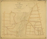
| 295-07 CP |
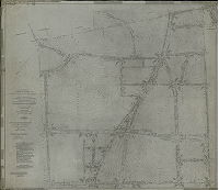
|
Revision of lines and grades of City Plan No. 295 … Twenty-first Ward, Philadelphia. [Ordinances Sept. 12, 1916 and Feb. 21, 1927; confirmed Feb. 18 and May 20, 1929] | Granlund, K. W. | 1929 |
Tracing
53 x 62 in.
|
Roxborough. Bounded by Hagy's Mill Rd., Montgomery County line, Wissahickon Ave. and Port Royal Ave.
Topography, streams
|
| 296-01 MTD |
|
Plan of the survey and regulation of the Twentieth Section, Twenty-first Ward, City of Philadelphia [Resolution, April 5, 1876; confirmed Nov. 21, 1887] | Levering, John H. | 1887 |
Mounted
78 x 42 in.
|
21st Ward, 20th Section. Bounded by Ridge Ave. to Manayunk Canal, Wigard St. to Port Royal Ave.
Topography, streams, springs, building footprints, Lower Roxborough Reservoir
|
| 296-04 MTD tracing |

|
Plan of the revision of lines and grades of part of Plan No. 296, Twenty-first Ward, Philadelphia. [Ordinance Dec. 8. 1892; portion below Shawmont Ave. confirmed Aug. 7, 1893] | Sundstrom, C. A. | 1893 |
Tracing
32 x 38 in.
|
Roxborough. Bounded roughly by Ridge Ave., Port Royal Ave. and Cross St.
Topography, Upper and Lower Roxborough Reservoirs
|
| 297-06 MTD tracing |
|
Plan of the survey and regulation of the Twenty-first Section, Twenty-first Ward, Philadelphia. [Ordinance April 5, 1876; Summit Ave. confirmed April 3, 1916; copy of plan made ca. 1900] | Levering, John H. | 1876 ca. |
Blueprint
57 x 47 in.
|
21st Ward, 21st Section. Bounded by Wissahickon Ave. to Ridge Ave., Port Royal Ave. to Wigard Ave.
Topography, streams, ponds, building footprints
|
| 298-03 MTD |

|
Plan of the survey and regulation of the Nineteenth Section, Twenty-first Ward, Philadelphia [Resolution June 19, 1876; confirmed June 3, 1878] | Levering, John H. | 1878 |
Mounted
54 x 31 in.
|
21st Ward, 19th Section. Bounded by Wissahickon Ave. to Leukon St., Roxborough Ave. to Hermit St.
Topography (except within Fairmount Park boundaries), Wissahickon Creek and tributary streams, building footprints
|
| 298-09 MTD |

|
Plan of revision of lines and grades of Wissahickon Ave., Hermit St. to Johnson St., Twenty-first Ward, Philadelphia [Ordinance April 4, 1902; confirmed April 6, 1903] | Sundstrom, C. A. | 1903 |
Mounted
19 x 30 in.
|
21st Ward, Wissahickon Ave., Hermit St. to JohnSon St.
Curb elevations
|
| 298-11 MTD |

|
Plan of Ampho Street, Washington Lane to Johnson St., Twenty-first Ward, Philadelphia [Ordinance April 4, 1903; rejected Feb. 19, 1906] | Sundstrom, C. A. | 1906 |
Mounted
21 x 20 in.
|
21st Ward
Curb elevations
|
| 298-12 MTD |
|
Plan of the revision of lines and grades of Plan 298, Twenty-first Ward Philadelphia [Ordinance July 18, 1905; confirmed 1906 and 1908] | Sundstrom, C. A. | 1906 |
Mounted
44 x 52 in.
|
21st Ward. Bounded roughly by Roxborough Ave to Hermit St., Rochelle Ave. to Wissahickon Ave., and bisected by Wissahickon Creek.
Topography, streams, building footprints
|
| 298-14 MTD |
|
Part of Plans 298 and 311, striking from the City Plan Horter [Hortter] Street from Cliveden Ave. to Wissahickon Ave. and to place on the City Plan Upsal St. and Sharpnack St. from Wissahickon Ave. to Park Line Drive, 21st Ward [Ordinance June 13, 1906 and amended Dec. 21, 1908; confirmed March 29, 1909] | Sundstrom, C. A. | 1909 |
Mounted
24 x 22 in.
|
21st Ward
Curb elevations
|
| 298-16 MTD |

|
Plan of the revision of lines and grades of part of Plan No. 298, Twenty-first Ward, Philadelphia [Ordinance Feb. 15, 1911; survey returned June 1911; confirmed March 18, 1912] | Sundstrom, C. A. | 1911 |
Mounted
32 x 33 in.
|
21st Ward
Topography
|
| 298-19 MTD |
|
Plan of the revision of lines and grades of Plan No. 298, Twenty-first Ward [Ordinance Feb. 17, 1913; confirmed Feb. 2, 1914] | Not named | 1914 |
Mounted
45 x 55 in.
|
21st Ward. Bounded roughly by Henry Ave. to Wissahickon Ave., Hortter St. to Hermit La.
Topography
|
| 299-02 MTD |

|
Plan of survey and regulation of the Twenty-second Section, Twenty-first Ward, Philadelphia [Ordinance April 5, 1876; confirmed March 21, 1887] | Levering, John H. | 1876 ca. |
Mounted
56 x 45 in.
|
21st Ward, 22nd Section
Topography
|
| 299-03 MTD |

|
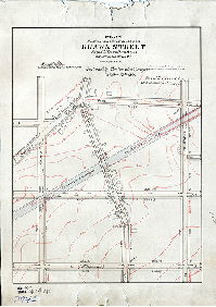
Plan of the revision of lines and grades of Ridge Avenue from Fountain Street to Domino Lane, Twenty-first Ward, City of Philadelphia [Resolution April 2, 1887; confirmed Dec. 3, 1888] | Sundstrom, C. A. | 1888 |
Mounted
30 x 41 in.
1 inch = 100 feet
|
Ridge Avenue, Roxborough
Curb elevations
|
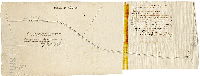
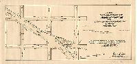
| 299-05 MTD |
|
Road in Roxborough from Ridge Road to Livezey’s Mill between seventh and eighth mile stones. Filed April 22nd, 1833. July 1, 1833 confirmed nisi. Confirmed absolutely October 22nd 1833. Extract from Road Book No. 11 Page 247 &c in the office of the Clerk of the Court of Quarter Sessions. | Not named | 1833 |
Tracing
13 x 33 in.
|
Roxborough. Livezey Road
Line of Livezey Road
|
| 299-05 MTD large |
|
Plan of the revision of portion of Plan No. 299 [Ordinance Jan 12, 1900; confirmed Jan. 18, 1915] | Sundstrom, C. A. | 1915 |
Mounted
27 x 31 in.
1 inch = 100 feet
|
Roxborough
Topography, building footprints, streams, pond
|
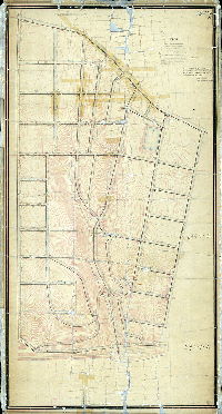
| 299-06-07 MTD |
|
Plan of the revision of lines and grades of City Plan No. 299 bounded by Gorgas Lane, Ridge Ave. Wigard Ave. and Wissahickon Creek in the Twenty-first Ward Philadelphia [Ordinance Sept. 12, 1916; confirmed 1920 and 1923] | Granlund, K. W. | 1920 |
Mounted
62 x 54 in.
|
Bounded by Gorgas Lane, Ridge Ave. Wigard Ave. and Wissahickon Creek
Topography, streams, ponds, extension of Fairmount Park approved by ordinance of Dec. 17, 1919
|
| 299-07 MTD |
|
Plan of revision of lines and grades of part of Plan No. 299, Twenty-first Ward, Philadelphia [Ordinance Nov. 28, 1891; no confirmation date] | Sundstrom, C. A. | 1891 |
Mounted
39 x 37 in.
1 inch = 100 feet
|
Roxborough. Bounded roughly by Livezy St., Magdalena St., Gorgas St. and ridge Ave.
Topography
|
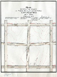
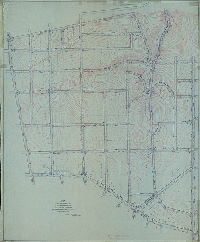
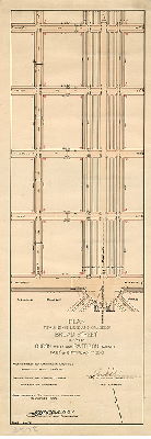
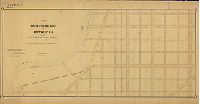
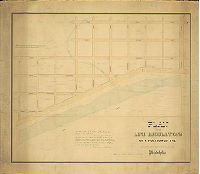
| 300-01 HP |

|
Plan of the establishment of lines and grades on City Plan No. 300 from Broad St. to 25th St. and from Curtin St. to Hastings St. [Ordinances Jan. 7, 1878, Dec. 28, 1895, and Jan. 17, 1898; confirmed Oct. 19, 1903] | Nobré, John M. | 1903 |
Mounted
35 x 58 in.
|
South Philadelphia
Curb elevations
|
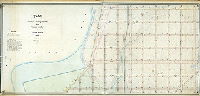
| 300-02 HP |
|
Plan of survey and regulation with topography of the Seventh Section, Twenty-sixth Ward [Resolution Jan. 7, 1878] | Cranmer, William C. | 1878 ca. |
Mounted
35 x 66 in.
1 inch = 100 feet
|
South Philadelphia. Bounded by Broad to 25th Sts., Curtin St. to Ave 38 S
Topography, Hollanders Creek, Shackhansing Creek, Shedbrook Creek, building footprints color coded, marshland, drainage canals, river bank
|
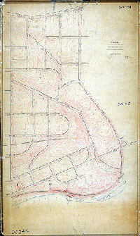
| 300-03 HP |
|
Plan revising the grades of Broad Street between Pattison Avenue and Hastings Street in the 26th and 39th Wards Philadelphia. Part of City Plan 300. [Ordinances Dec. 28, 1895 and March 10, 1905; survey returned May 27, 1905; confirmed Oct. 2, 1905] | Nobré, John M. | 1905 |
Mounted
17 x 44 in.
|
South Philadelphia. League Island Park, bounded by Pattison Ave., Broad St., Hastings St. (not shown) and 20th St.
League Island Park, with Hollanders Creek feeding into a lake
|
| 300-04 HP |
|
Plan revising the lines and grades of Broad Street between Curtin Street and Pattison Avenue. Part of City Plan No. 300. [Ordinance April 29, 1913; confirmed August 11, 1913. Same as 304-07_HP] | Nobré, John M. | 1913 |
Mounted
32 x 12 in.
|
South Philadelphia
Curb elevations
|
| 300-05 HP |
|
Plan for placing on the City Plan Penrose Avenue from Curtin St. to New Penrose Ave. 36th Ward, Philadelphia. [Ordinance Jan. 26, 1907; plan made Feb. 11, 1907; confirmed March 25, 1907] | Nobré, John M. | 1907 |
Mounted
12 x 23 in.
|
South Philadelphia
Curb elevations
|
| 300-06 HP |

|
Plan revising the lines and grades of Broad Street between Curtin St. and League Island Park making Broad St. 300 ft. wide. Part of City Plan No. 300. [Ordinance June 16, 1904; plan made Nov. 14, 1904; confirmed Jan. 16, 1905] | Nobré, John M. | 1904 |
Mounted
35 x 12 in.
|
South Philadelphia
Curb elevations
|
| 300-07 HP |
|
Plan revising the lines and grades of Broad Street between Curtin Street and Pattison Avenue. Part of City Plan No. 300. [Ordinance April 29, 1913; confirmed August 11, 1913. Same as 304-04_HP] | Nobré, John M. | 1913 |
Mounted
32 x 12 in.
|
South Philadelphia
Curb elevations
|
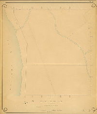
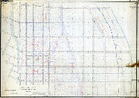
| 301-01 HP |
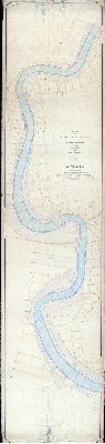
|
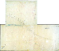
Plan of the Schuylkill River below South Street showing low water line and street connections [and] Port Wardens Lines on the Schuylkill River [Ordinance Dec. 19, 1877; approved by the United States Advisory Board of the Philadelphia Harbor Commission Oct. 15, 1883; confirmed by Board of Surveyors Oct.15,1883 and by Councils ordinance March 8,1884] | Cranmer, William C. | 1883 |
Mounted
57 x 246 in.
1 inch = 100 feet
|
Schuylkill River from South St. to Delaware River
Soundings with profile view, river banks, rocks, bridges, many other features
|
| 302-01 HP |
|
Plan of the revision of lines and grades on City Plan No. 302 bounded by Curtin Street, Hastings Street, 25th Street, and Schuylkill River [Ordinances Jan. 7, 1873 and Dec. 28, 1895, survey returned March 26, 1905; confirmed June 4, 1906] | Nobré, John M. | 1905 |
Mounted
37 x 75 in.
1 inch = 100 feet
|
South Philadelphia. Bounded by Curtin St., Hastings St., 25th St., and Schuylkill River
Topography (1-foot contours), curb elevations creeks, river bank
|
| 302-z HP |
|
Plan of survey and regulation with topography of the Eighth Section, Twenty-sixth Ward[ Resolution Jan. 7, 1878] | Cranmer, William C. | 1878 ca. |
Mounted
34 x 72 in.
|
South Philadelphia, 26th Ward, 8th Section. Bounded by 25th St. to Schuylkill River, Curtin St. to Avenue 38 South
Topography, streams, high water bank, low water line, building footprints. Marsh meadow (below -5 elevation) is shaded green.
|
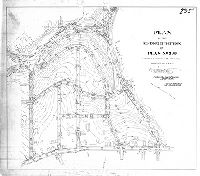
| 303-01 MTD |

|
Plan of the revision of the lines and grades of Umbria St., formerly Washington St,. from Parker Ave. to Shawmont Ave., Twenty-first Ward Philadelphia [Ordinances 1876 and 1889; confirmed 1899 and 1908] | Sundstrom, C. A. | 1899 |
Mounted
29 x 70 in.
|
21st Ward. Umbria Street, from Shawmont Ave. to Lemonte St.
Topography, streams, building footprints, railroads
|
| 303-03 MTD |
|
Plan of the survey and regulation of the Twenty-third Section. Twenty-First Ward Philadelphia [Ordinance April 5, 1876; no confirmation date] | Levering, John H. | 1876 ca. |
Mounted
55 x 33 in.
|
21st Ward, 23rd Section.
Topography, streams, building footprints
|
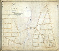
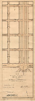
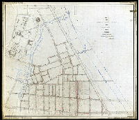
| 304-01 HP |

|
Plan revising the grades of Broad Street from Hastings St. to Government Ave. and Government Ave. from Broad St. to Twentieth St. Park of City Plan No. 304, 26th & 36th Wards, Philadelphia [Ordinances Dec. 28, 1905 and March 10, 1905; survey returned May 27, 1905; confirmed Oct. 2, 1905] | Nobré, John M. | 1905 |
Mounted
43 x 39 in.
|
South Philadelphia, League Island Park
League Island Park, Hollanders Creek, lakes
|
| 304-02 HP |
|
Plan of League Island Park as ordered to be placed upon the City Plan by ordinance approved July 2, 1894 [Survey returned Jan. 23, 1895; confirmed May 6, 1895] | Daly, Thomas, and Close, C. W. | 1895 |
Mounted
57 x 50 in.
|
South Philadelphia, League Island Park
Hollanders Creek, Magazine Lane, Island Road
|
| 304-03 HP |

|
Plan of survey and regulation of the Ninth Section, Twenty-sixth Ward Philadelphia [Resolution Jan. 7, 1878; not confirmed] | Not named | 1878 ca. |
Mounted
49 x 53 in.
|
South Philadelphia. 26th Ward, 9th Section.
Topography (partial), Shedbrook Creek, Hollanders Creek
|
| 304-04 HP |

|
Plan of the establishment of lines and grades on City Plan No. 304 from 20th St. to 25th St. and from Hastings St. to Government Ave. [Ordinances Jan. 7, 1878 and Dec. 28,1895; confirmed Oct. 19, 1903] | Nobré, John M. | 1903 |
Mounted
30 x 48 in.
|
South Philadelphia. Bounded by 20th to 25th Sts., Government Ave. to Hastings St.
Curb elevations
|
| 304-z HP |
|
Plan of the line regulations of a portion of the Twenty-sixth Ward Philadelphia [Approved by Board of Surveyors Dec. 7, 1868; confirmed by Court June 28, 1869] | Not named | 1868 |
Mounted
45 x 53 in.
1 inch = 100 feet
|
South Philadelphia, 26th Ward. Broad to 23rd, Avenue 40 South to Back Channel
Curb elevations, building footprints, Hollanders Creek, Back Channel
|
| 305-07 MTD tracing |
|
Plan of the revision of lines and grades on the Third Section 25th Ward Philadelphia. [Ordinance June 5, 1877; confirmed 1888 and 1890] | Not named | 1888 |
Tracing
54 x 74 in.
|
25th Ward, 3rd Section. Bounded by Frankford Creek, Lefevre St., Delaware River, and Pike and Luzerne Sts.
Topography seems to end at -5 elevation; Frankford Creek, streams, tidal marshland inferred, river bank
|
| 306-03 MTD tracing |
|
Plan of the revision of lines and grades on the Fourth Section, 25th Ward Philadelphia [Ordinance June 5, 1877; confirmed Oct. 19, 1885] | Not named | 1885 |
Tracing
53 x 62 in.
1 inch = 100 feet
|
25th Ward, 4th Section. Bounded roughly by Sanger St. to Lefevre St., Frankford Creek to Delaware River.
Topography on part of plan, building footprints of entire Frankford Arsenal, mouth of Frankford Creek, Port Warden's Line
|
| 308-01 MTD |

|
Plan of the revision of grades on Dock Street between Third Street and Delaware Avenue. [Resolution June 23, 1862; surveyed Dec. 1862; confirmed July 1, 1864] | Shedaker, David Hudson | 1862 |
Mounted
27 x 32 in.
1 inch = 50 feet
|
Dock Street
Attachment: handwritten Act, two pages with seal. Resolution also pasted directly pn plan.
|
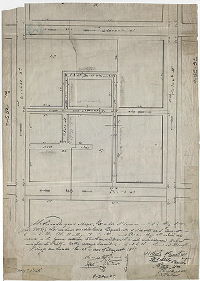
| 308-08 MTD |
|
We the undersigned Mayor, Recorder, Alderman and City Regulator do certify that we have established a regulation of ascents and descents in Currant Alley, Plumb Alley, Burds Alley, and Poplar Alley, all which are situate in the square between Tenth and Eleventh Streets and between Walnut and Locust Streets - as the same is described and set forth in the above draft. Witness our hands the 28th day of August 1818 ... | Hains, Samuel; Ireland, Alphonso | 1818 |
Tracing
19 x 14 in.
1 inch = 40 feet
|
Philadelphia
Alley streets in Center City
|
| 308-08a MTD |

|
We the undersigned Mayor, Recorder, Alderman and City Regulator do certify – That on the 3d day of July 1830 – We did establish a Regulation of Ascents and descents in Rose Alley and Thorn alley – which are situated between Tenth Street and Currant Alley and between Second and Walnut Streets – as the same are described and set forth in the annexed draft. Witness our hands the 18th day of October 1830 ... | Hains, Samuel | 1830 |
Tracing
13 x 12 in.
1 inch = 30 feet
|
Philadelphia
Alley streets in Center City
|
| 309-01 HP |

|
Plan of the revision of lines & grades on City Plan No. 309 from 25th St. to [Schuylkill] River, and south from Hastings St. [Ordinances Dec. 28, 1895 and April 6, 1897; confirmed Feb. 20, 1905.] | Nobré, John M. | 1905 |
Mounted
52 x 72 in.
|
South Philadelphia. Bounded by 25th St. to Schuylkill River, and from Hastings St. south.
Curb elevations, river bank, bulkhead line, E. C. Knight Park
|