
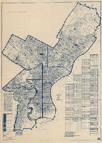
Philadelphia Streets Department Surveys
2755 result(s). Showing results 1301 to 1350.
View page: 1 2 3 4 5 6 7 8 9 10 11 12 13 14 15 16 17 18 19 20 21 22 23 24 25 26 27 28 29 30 31 32 33 34 35 36 37 38 39 40 41 42 43 44 45 46 47 48 49 50 51 52 53 54 55 56 (Show all on one page)
| Identifer | Preview | Title | Surveyor | Date | Media / Size / Scale | Area / Map Features |
| 359-01 MTD tracing |

|
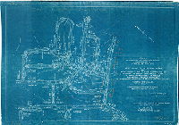
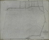
Plan to establish lines and grades and to place upon City Plan No. 359 Bensalem Avenue from Red Lion Road to Byberry Road, Thirty-fifth Ward Philadelphia [Ordinance March 2, 1921; confirmed May 2, 1921] | Webster, Clement B. | 1921 |
Tracing
24 x 82 in.
1 inch = 100 feet
|
Northeast Philadelphia. Bensalem Avenue, from Red Lion Road to Byberry Road, and area on either side
Topography, streams, pond, building footprints, driveways, old roads
|
| 360-01 MTD |
|
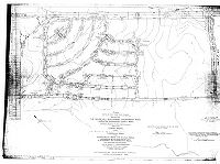
Plan to establish lines and grades and place upon City Plan No. 360 Bensalem Avenue from Byberry Road to Poquessing Creek 9Bucks County Line), Thirty-fifth-Ward, Philadelphia [Ordinance March 2, 1921; confirmed May 2, 1921] | Webster, Clement B. | 1921 |
Mounted
16 x 103 in.
1 inch = 100 feet
|
Northeast Philadelphia. Bensalem Ave. (now Roosevelt Boulevard) from Byberry Road to Poquessing Creek
Topography, streams, building footprints
|
| 361-01 CP |

|
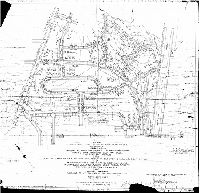
Plan revising the lines and grades and establishing new streets upon City Plan No. 361, 35th Ward, Philadelphia. [Ordinance July 20, 1907; confirmed Oct. 16 and Nov. 20, 1922] | Webster, Clement B. | 1922 |
Tracing
67 x 40 in.
|
Northeast Philadelphia. Bounded by Bustleton Ave., Grant Ave., Roosevelt Boulevard and Pennypack Park / Pennypack Creek
Topography, streams, ponds, building footprints, railroad
|
| 362-01 CP |

|
Plan establishing lines and grades on City Plan No. 362, Thirty-fifth Ward, Philadelphia. [Ordinance July 20, 1907; confirmed April 2, 1923] | Webster, Clement B. | 1923 |
Tracing
72 x 42 in.
|
Northeast Philadelphia. Bounded by Verree Rd., Welsh Rd. Krewstown Rd. and Pennypack Park
Topography, streams, building footprints
|
| 363-01 CP |
|
Plan establishing lines and grades upon City Plan No. 363, Thirty-fifth Ward, Philadelphia [Ordinance July 20, 1907; confirmed July 2, 1923] | Webster, Clement B. | 1923 |
Tracing
65 x 54 in.
1 inch = 100 feet
|
Northeast Philadelphia. Bounded by Byberry Rd., Bustleton Ave., Lawler Ave. and Montgomery County line
Topography, streams, railroad, building footprints
|
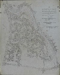
| 365-02 CP |
|
City Plan No. 365. Revising lines and grades and establishing new streets in territory bounded by Strahle St., Horrocks St., Pennypack Park and Algon Ave.. Thirty-fifth Ward Philadelphia. [Ordinance July 20, 1907; confirmed Oct. 18, 1926] | Blankley, William W., and [Daumer?], Edward J. | 1926 |
Tracing
53 x 44 in.
1 inch = 100 feet
|
Northeast Philadelphia. Bounded by Strahle St. Horrocks St., Pennypack Park and Algon Ave.
Topography, Pennypack Creek and tributary streams, building footprints
|
| 366-01 CP |

|
Plan establishing and revising lines and grades on City Plan No. 366, Thirty-fifth Ward Philadelphia [Ordinances July 20, 1907 and April 3, 1924; confirmed June 30, 1924] | Webster, Clement B. | 1924 |
Tracing
|
Northeast Philadelphia. Bounded by Frankford Ave., Willits Ave., Rowland Ave., Outlook Ave., and Grant Ave.
Topography
|
| 366-02 MTD |

|
Plan for widening and revising the grades of Grant Avenue from Frankford Avenue to Starkey Street, 35th Ward, Philadelphia. [Ordinance March 31, 1903; survey returned May 17, 1907; confirmed Nov. 4, 1907] | Webster, Clement B. | 1907 |
Mounted
39 x 168 in.
|
Northeast Philadelphia. Grant Avenue from Frankford Ave. to Starkey St., and surrounding area
Topography, streams, Poquessing Creek, Byberry Creek, bridges, building footprints, driveways and old roads
|
| 367-06 SD4th |

|
Plan placing upon City Plan No. 367 Gregg Street … and Banes Street … Colima Road … and … right-of-way for drainage purposes. Thirty-fifth Ward, Philadelphia. [Ordinance April 18, 1957; confirmed May 20, 1957. Originally numbered R-5-33] | LeQuin, Howard | 1957 |
Blueprint
17 x 36 in.
|
Northeast Philadelphia
Topography
|
| 369-02 CP |

|
Plan of the revision of lines and grades and establishing new streets upon City Plan No. 369 parts of former Plans No. 325, 337, 338, 339, and placing upon the City Plan an extension of Pennypack Park, Thirty-fifth Ward Philadelphia [Ordinances Dec. 22, 1915 and Jan. 23, 1917; survey returned Dec. 15, 1924; confirmed March 2, 1925. No color in original] | Blankley, William W. | 1924 |
Tracing
54 x 36 in.
|
Northeast Philadelphia. Bounded by Roosevelt Blvd., Sandyford Ave., Ryan Ave., Lexington Ave., and Rhawn St.
Topography, Sandy Run and tributary streams
|
| 370-01 CP |

|
Plan of the revision of lines and grades and establishing new streets upon City Plan No. 370, part of former Plan No. 327… Thirty-fifth Ward, Philadelphia [Ordinance July 20, 1907; confirmed April 19, 1926] | Blankley, William W. | 1926 |
Tracing
57 x 51 in.
1 inch = 100 feet
|
Northeast Philadelphia. Bounded by Byberry Rd., Montgomery County line, Erwin St., County Line Rd., Trevose Ave. and Bustleton Ave.
Topography, streams, building footprints, driveways
|
| 371-01 CP |

|
Plan of the revision of lines and grades and establishing new streets upon City Plan No. 371 (parts of former Plans No. 281,337,338,339), Thirty-fifth Ward Philadelphia. [Ordinance Jan. 23, 1917; confirmed April 19, 1926] | Blankley, William W. | 1926 |
Tracing
41 x 53 in.
|
Northeast Philadelphia. Bounded by Pennypack Park (Sandyford and Hartel Aves.), Rowland Ave., Cottman Ave., and Roosevelt Blvd.
Topography, streams, building footprints
|
| 372-01 CP |
|
Plan establishing lines and grades on City Plan No. 372…. Thirty-fifth Ward, Philadelphia [Ordinance July 20, 1907; confirmed April 19, 1926] | Blankley, William W. | 1926 |
Tracing
38 x 34 in.
|
Northeast Philadelphia. Bounded by Knights Ave., Ellicott Rd. Orchard La., Poquessing Creek, and Frankford Ave.
Topography, old road
|
| 374-01 CP |

|
Plan of the revision of lines and grades and establishing new streets upon City Plan No. 371 … Thirty-fifth Ward, Philadelphia. [Ordinance July 20. 1907; confirmed Jan. 3, 1927] | Blankley, William W. | 1927 |
Tracing
54 x 39 in.
|
Northeast Philadelphia. Bounded by Lott Ave., Bensalem Ave,. Red Lion Rd. and Blue Grass Rd.
Topography, streams, building footprints
|
| 376-01 SD4th |
|
Plan establishing the lines and grades on a portion of City Plan No. 376 lying northeast of Byberry Road and Northwest of Dunks Ferry Road … Thirty-Fifth Ward, Philadelphia [Ordinance Oct. 21, 1952; confirmed Sept. 15, 1953] | Hornig, Philip H. | 1953 |
Blueprint
24 x 34 in.
|
Northeast Philadelphia, vicinity of Byberry Rd. and Dunks Ferry Rd.
Topography
|
| 377-01 CP |

|
Plan revising the lines and grades on that portion of City Plan No. 377 bounded by Byberry Road, Dunks Ferry Road, Mechanicsville Road, property line of ground owned by the City (Potter’s Field) Philadelphia-Bucks County Line (Poquessing Creek) and property lines of ground registered in the names of Meadow Holding Co., Orchard Holding Co., and Hampton Holding Co. [by placing new streets and rights-of way on the Plan, and widening, vacating and revising the lines and grades of streets]. 58th Ward, Philadelphia [Ordinance July 30, 1958; confirmed Nov. 7, 1958] | McDevitt, John J. | 1958 |
Tracing
35 x 51 in.
1 inch = 100 feet
|
Northeast Philadelphia
Topography
|
| 377-02 CP |

|
Plan revising the lines and grades on a portion of City Plan No. 377, bounded by Knights Road, property lines of the School District of Philadelphia, property line of the Hampton Holding Co., lines of area placed upon the City Plan for public purposes, Medford Road and Mechanicsville Road; and placing upon the City Plan Nanton Drive, Mechanicsville Road, Medford Road, Academy Road, Knights Road, Biscayne Drive, Genesee Drive, Vader Drive, Bellaire Road, Deerrun Road, Bandon Drive, Canby Drive, Friar Road, Westhampton Drive, Verda Drive, Biscayne Place, Nanton Place, Nanton Terrace, Genesee Place, Deerrun Place, Bellaire Place, Knights Terrace, Grayton Place, Friar Place, Mechanicsville Place and Knights Place; and placing upon the city plan a certain area to be dedicated for public purposes; 58th Ward, Philadelphia. [Ordinance March 8, 1953; confirmed May 4, 1959] | McDevitt, John J. | 1959 |
Tracing
36 x 46 in.
|
Northeast Philadelphia
Topography
|
| 377-05 SD4th |

|
Plan revising the lines and grades on a portion of City Plan No. 377, bounded by Byberry Road, Dunks Ferry Road, Belgreen Road, Medford Road and Academy Road [by striking from the plan one street and adding several streets and rights-of-way], 58th Ward, Philadelphia [Ordinance Dec. 24, 1959; confirmed Feb. 15, 1960] | McDevitt, John J. | 1960 |
Blueprint
22 x 35 in.
|
Northeast Philadelphia
Topography
|
| 378-01 CP |

|
Plan to establish the lines and grades upon City Plan No. 378, bounded Ninetieth St, Back Channel, Bow Creek, county line, and Tinicum Ave. Fortieth Ward Philadelphia. [Ordinance Oct. 4, 1916; advertised May 7, 1928; confirmed May 19, 1930] | Engle, Amos B. | 1930 |
Tracing
55 x 36 in.
1 inch = 100 feet
|
Southwest Philadelphia. Bounded by 90th St, Back Channel, Bow Creek, county line, and Tinicum Ave.
Bow Creek, Church Creek, drainage streets, dikes or ditches, property lines
|
| 379-01 CP |

|
Plan placing upon that portion of City Plan No. 379 bounded by Academy Road, Red Lion Road, East Keswick Road, Morrell Avenue, drainage right-of-way along the line of Byberry Creek, the line of Avalon Street extended and Avalon Street [numerous streets] and rights of way for drainage and water pipe purposes, and certain areas to be dedicated for public purposes, pursuant to Section 11-402 of the Philadelphia Code, 58th Ward, Philadelphia [Ordinance Nov. 3, 1960; approved by City Planning Commission Nov. 29, 1960; confirmed April 3 and May 15, 1961] | McDevitt, John J. | 1961 |
Tracing
41 x 44 in.
|
Northeast Philadelphia
Topography
|
| 380-02 CP |

|
Plan to revise the lines and grades on a portion of City Plan No. 380 bounded by Academy Road, Comly Road and property lines of a tract registered in the name of Joseph N. Gorson by placing upon the City Plan [15 streets], by placing upon the City Plan an area along the line of and adjacent to Byberry Creek (North Branch) to be dedicated to the city for public purposes, and certain rights-of-way for water pipe and drainage purposes. 58th Ward, City of Philadelphia. [Ordinance Sept. 18, 1958; confirmed Dec. 15, 1958; approved by City Planning Commission Jan. 6, 1959] | Franklin & Lindsey | 1958 |
Tracing
36 x 31 in.
1 inch = 100 feet
|
Northeast Philadelphia. Bounded roughly by Comly Road, Academy Road, Byberry Creek and Colman Road.
Topography
|
| 381-02 SD4th |

|
Plan to establish the lines and grades upon a portion of City Plan No. 381 lying northeast of Southampton Road and east of Worthington Road and the Philadelphia-Bucks County Line ... Thirty-Fifth Ward, Philadelphia [Ordinance Nov. 30, 1949; confirmed Nov. 6, 1950. Originally numbered P-16-33] | Engle, Amos B. | 1950 |
Blueprint
26 x 36 in.
|
Northeast Philadelphia
Topography
|
| 383-02 SD4th |

|
Plan to establish the lines and grades upon a portion of City Plan No. 383 bounded by Southampton Road, New York Short Line Railroad, Poquessing Creek (Bucks County Lines) and Carter Road … Thirty-fifth Ward, Philadelphia. [Ordinance Oct. 5, 1949; confirmed March 6, 1950. Originally numbered P-17-20] | Engle, Amos B. | 1950 |
Blueprint
26 x 36 in.
|
Northeast Philadelphia
Topography
|
| 383-03 SD4th |

|
Plan to revise the lines and grades of that portion of City Plan No. 383 bounded by Herschel Road … Endicott Street, Poquessing Creek Drive … New York Short Line Railroad, Poquessing Creek and Carter Road … Thirty-fifth Ward, Philadelphia [Ordinance May 22, 1954; confirmed Sept. 20, 1954. Originally numbered P-31-56] | McDevitt, John J. | 1954 |
Blueprint
24 x 35 in.
|
Northeast Philadelphia
Topography
|
| 383-05 SD4th |

|
Plan placing upon City Plan No. 383 London Road from Southampton Road to Hershel Road [and several other streets]. 58th Ward, Philadelphia [Ordinance Sept. 18, 1958; confirmed Nov. 7, 1958. Originally numbered R-7-18] | McDevitt, John J. | 1958 |
Blueprint
22 x 34 in.
|
Northeast Philadelphia
Topography
|
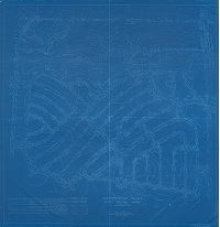
| 386-01 CP |
|
Plan establishing lines and grades upon a portion of City Plan No. 386 bounded by the Roosevelt Boulevard, Woodhaven Road, Thornton Road and Comly Road, and placing upon the City Plan streets, roads, drives and avenues and also Comly Road from the Roosevelt Boulevard to Thornton Road, Thornton Road from Woodhaven Road to Comly Road, Woodhaven Access Road extended to Thornton Road, and drainage rights-of-way and revising the lines and grades of streets affected thereby. Thirty-fifth Ward, Philadelphia [Ordinance March 18, 1955; confirmed April 11, 1955] | McDevitt, John J. | 1955 |
Blueprint
34 x 48 in.
1 inch = 100 feet
|
Northeast Philadelphia. Bounded by Woodhaven Rd., Comly Rd., Roosevelt Blvd. and Thornton Rd.
Topography
|
| 386-02 SD4th |

|
Plan establishing the lines and grades upon a portion of City Plans No. 386, bounded by The Roosevelt Boulevard, Woodhaven Road, Thornton Road and Comply Road ... Thirty-fifth Ward, Philadelphia [ Ordinance March 18, 1955; confirmed April 11, 1955] | Shegog, George T. | 1955 |
Blueprint
36 x 51 in.
|
Northeast Philadelphia
Topography
|
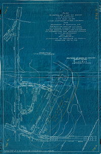
| 388 HP |
|
Plan and profiles showing properties taken and affected by the opening of [sections of] Roberts Ave. … Abbottsford Ave. … 31st (Fox) St. … 32nd (McMichael) St., Twenty-Eighth Ward, Philadelphia | Fuller, H. M. | 1894 |
Photostat, Mounted
39 x 78 in.
1 inch = 100 feet
|
East Falls
Topography, property lines, profile
|
| 389-y CP blueprint |
|
Plan placing upon that portion of City Plan No. 389 bounded by Verree Road, property lines southwest of Medway Road, Paul's Run drainage right-of-way, Northeast Avenue, and the southwest line of the Philadelphia Electric Company's right-of-way [nine streets] pursuant to section 11-402 of the Philadelphia Code. Fifty-eighth Ward, Philadelphia [Ordinance March 8, 1957; confirmed Sept. 16, 1957] | McDevitt, John J. | 1957 |
Blueprint
36 x 39 in.
|
Northeast Philadelphia
Topography
|
| 389-z CP blueprint |

|
Plan placing upon City Plan No. 389 [numerous streets and drainage rights-of-way] in the area northwest of Northeast Avenue, southeast of Woodfern Road, and southwest of the Philadelphia electric Company's right-of-way, pursuant to section 11-402 of the Philadelphia Code ... Thirty-fifth Ward, Philadelphia [Ordinance Jan. 2, 1957; confirmed May 20, 1957] | McDevitt, John J. | 1957 |
Blueprint
38 x 50 in.
|
Northeast Philadelphia
Topography
|
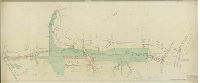
| 390-03 SD4th |

|
Plan to revise the lines and grades of Grant Avenue from The Roosevelt Boulevard to Academy Road … 35th Ward, Philadelphia. [Ordinance Nov. 24, 1948; confirmed Jan. 3, 1949] | Engle, Amos B. | 1948 |
Blueprint
13 x 82 in.
|
Northeast Philadelphia. Grant Avenue from Roosevelt Blvd. tyo Academy Road
Topography
|
| 391 CP |
|
Plan of City Plan No. 391 and portion of City Plan No. 363 to revise the lines and grades … Thirty-fifth Ward, Philadelphia [Ordinance July 16, 1936; confirmed July 6, 1942] | Daumer, Edward J. | 1942 |
Tracing
55 x 67 in.
1 inch = 100 feet
|
Northeast Philadelphia. Bounded by Burgess St. and Tomlinson Rd., Montgomery County line, Red Lion Rd., Verree Rd. and Bustleton Ave.
Topography, streams
|
| 392-02 SD4th |
|
Plan to establish lines and grades on a portion of City Plan No. 392 lying northeast of Red Lion Road and southeast of Bustleton Ave. … 35th Ward, Philadelphia [Ordinance May 5, 1952; confirmed Aug. 18, 1952] | Horrnig, Philip H. | 1952 |
Blueprint
33 x 22 in.
|
Northeast Philadelphia
Topography
|
| 392-03 SD4th |

|
Plan to establish the lines and grades upon a portion of City Plans Nos. 355 and 392 bounded by Bustleton Avenue, Tomlinson Road, proposed lines of Northeast Avenue and a property line southwest of Tomlinson Road … Thirty-fifth Ward, Philadelphia [Ordinance Jan. 19, 1954; confirmed Aug. 2, 1954. Originally numbered P-31-55] | McDevitt, John J. | 1954 |
Blueprint
24 x 27 in.
|
Northeast Philadelphia
Topography
|
| 393-398 CP |
|
City Plans Division, Bureau of Surveys and Design, Department of Streets, Jan. 28th, 1957. C.P. 393 & 398. 1. [Drainage area of what is commonly called Darlington Run, a Pennypack tributary, from Welsh Road to Bloomfield Street. Plan probably related to construction of interceptor sewer in 1950s.] | Not named | 1957 |
Paper
31 x 76 in.
1 inch = 100 feet
|
Northeast Philadelphia. Drainage area paralleling Darlington Road from Welsh Road to Bloomfield Street
Stream sometimes called Darlington Run, detail of right-of-way for drainage, references to other adjoining plans
|
| 394 CP |
|
Composite plan of City Plan #394, 35th Ward, Philadelphia. | LeQuin, Howard | 1957 |
Blueprint
53 x 54 in.
|
Northeast Philadelphia. Bounded by Willits Rd. Ashton Ave. Grant Ave., Outlook Rd. and Fordham Rd.
Topography, Wooden Bridge Run and other streams
|
| 395-01 CP |

|
Plan to establish a portion of City Plan No. 395 … and the placing upon City Plan Blue Grass Road … and the revision of grades on Blue Grass Road [Ordinance Aug. 31, 1959; survey returned Jan. 25, 1960; confirmed March 7, 1960] | Franklin & Lindsey | 1960 |
Tracing
80 x 49 in.
1 inch = 100 feet
|
Northeast Philadelphia. Bounded by Roosevelt Blvd., Grant Ave., Ashton Rd., Willits Rd. and Welsh Rd.
Topography, drainage right-of-way following course of stream
|
| 397-01 CP |
|
Plan revising the lines and grades on a portion of City Plan No. 397 … by placing upon the City Plan [various streets] … by placing upon the City Plan certain rights-of-way for drainage and water pipe purposes, and certain areas to be dedicated for public purposes. 58th Ward, Philadelphia [Ordinance Nov. 19. 1959; confirmed Feb. 15, 1960; approved by City Planning Commission, Jan. 10., 1961] | McDevitt, John J. | 1960 |
Tracing
54 x 43 in.
|
Northeast Philadelphia. Bounded by Academy Rd., Comly Rd., existing drainage right-of-way along line of Byberry Creek, and Red Lion Rd.
Topography, streams
|
| 397-02 CP |

|
Plan placing upon City Plan No. 397 Templeton Drive, from Greenacres Road to a property line southwest of Inwood Lane, Kirby Drive, from Greenacres Road to Templeton Drive, Kipling Lane, from Greenacres Road to Templeton Drive, Greenacres Road, from Waldemire Drive to Kipling Lane, Kane Road, from Kipling Lane to Knights Road, and Kipling Place, from Greenacres Road and Kipling Lane southeastwardly to a dead end; and to place upon the City Plan a right-of-way for water pipe purposes from the dead end of Kipling Place to Knights Road. 58th Ward Philadelphia. [Ordinance Oct.24, 1958; survey returned Dec. 10, 1958; confirmed Feb. 2, 1959] | Franklin & Lindsey | 1958 |
Tracing
27 x 31 in.
|
Northeast Philadelphia
Topography
|
| 397-03 CP |

|
Plan placing upon City Plans Nos. 372, 388 and 397 Red Lion Road, Waldemire Drive, Mill Brook Road, Millbrook Place, Brookview Road, Oakhill Road, Dorchester Road, Inwood Lane, Templeton Drive and Kipling Lane, in the area northwest of Knights road and northeast of Red Lion Road, and revising the lines and grades of Knights Road pursuant to Section 11-405 of the code. Thirty-fifth Ward, Philadelphia [Ordinance Jan. 7, 1957; confirmed April 15, 1957] | McDevitt, John J. | 1957 |
Tracing
32 x 60 in.
|
Northeast Philadelphia
Topography
|
| 398 CP |

|
Plan establishing the lines and grades upon a portion of City Plans Nos. 393 and 398 … Thirty-fifth Ward, Philadelphia [ Ordinance Dec. 26, 1955; confirmed June 4, 1956; approved by City Planning Commission June 20, 1956; revised June 21, 1957 | LeQuin, Howard; McDevitt, John J. | 1957 |
Tracing
49 x 80 in.
1 inch = 100 feet
|
Northeast Philadelphia. Bounded roughly by Pine Rd., Welsh Rd., Verree Rd. and Bloomfield Ave.
Topography, streams
|
| 399-400 CP |
|
Plan revising the lines and grades on portions of City Plans Nos. 399 and 400 bounded by The Roosevelt Boulevard, Comly road, Academy Road and Red Lion Road … and placing upon the City Plan [various streets] and widening Comly Road … and placing upon the City Plan rights-of-way for drainage purposes. Fifty-eighth Ward, Philadelphia. | McDevitt, John J. | 1959 |
Tracing
34 x 46 in.
|
See title for plan extent.
Topography, streams,
|
| 400-01 CP |

|
Plan revising the lines and grades on portions of City Plans Nos. 399 and 400 … and placing upon the City Plan [various streets] and widening Comly Road … and placing upon the City Plan rights-of-way for drainage purposes. Fifty-eighth Ward, Philadelphia. [Ordinance Jan. 30, 1959; confirmed April 6, 1959; approved by City Planning Commission April 21, 1959] | McDevitt, John J. | 1959 |
Tracing
34 x 46 in.
|
Northeast Philadelphia. Bounded by Roosevelt Blvd., Comly Rd., Academy Rd. and Red Lion Rd..
Topography, streams,
|
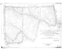
| 402 CP Airport1931 |

|
Plan showing boundaries - topography- buildings existing water front improvements, etc. proposed Metropolitan Airport | Thorpe, Frederick T., Jr. | 1931 |
Tracing
54 x 79 in.
1 inch = 200 feet
|
Southwest Philadelphia. Bounded roughly by Delaware River to Bartram and Penrose Aves., Island Rd. to Delaware County line
Detailed topography (including many negative elevations), creeks, ditches, dikes, river banks, soundings, old roads, railroads, property ownership and acreage, building footprints, Hog Island Shipyard (partly demolished), piers
|
| 402 CP SD7th |

|
Physical condition plan. Phila. Industrial Development Corp. Penrose & Fort Mifflin Tracts. N.W. side of Schuylkill River & Delaware River. City of Philadelphia, 40th Ward. Barton & Martin, Engineers. 12 So. 12th St., Philadelphia. September 30, 1968 [No color in original] | Barton and Martin | 1968 |
Mylar
48 x 48 in.
|
Southwest Philadelphia. Bounded by Schuylkill River, Delaware River, Penrose Ave. and Island Ave.
Topography, Fort Mifflin, Southwest Sewage Treatment Plant, piers, drainage ditches, disposal areas for dredge spoils, property lines and owners, sludge lagoons, I-95
|
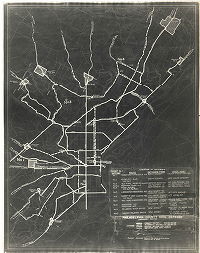
| FF-CivDef-01 |

|
Federal Works Agency Public Roads Administration. Philadelphia & vicinity transportation map. Highways, railroads, air lines, and dredged channels. Revised edition - 1943. Scale 1:125,000 [Overlay added ca. 1952] | Not named | 1952 ca. |
Paper
26 x 36 in.
|
Philadelphia and vicinity
Civil Defense. Concentric rings indicating damage and casualties from potential atomic bomb blast.
|
| FF-CivDef-03 |
|
Philadelphia County Civil Defense, Emergency Routes. Location of gateways. Revised June 29, 1951. | Not named | 1951 |
Paper
20 x 16 in.
|
Philadelphia
Civil Defense. Emergency routes in and out of the city.
|
| FF-CivDef-09 attachment2 |
|
The Bell Telephone Company of Pennsylvania. Accounting area - Philadelphia Division, and subsidiary areas recognized in the continuing property records. [Map overdrawn on Hagstrom's street and house number map of Philadelphia. Map no. 2251. For sale by J. L. Smith Co. | Not named | 1952 ca. |
Paper
22 x 17 in.
|
Philadelphia and vicinity
Telephone exchange areas
|
| FF-CivDef-14b |
|
[Title block obscured. Map showing location of all public schools in Philadelphia, with a cross-referenced alphabetical list. Original map from 1933, revised several times to 1950] | Not named | 1950 |
Blueprint, Positive
30 x 22 in.
|
Philadelphia
Location of public schools
|
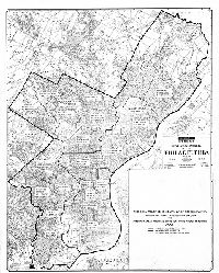
| FF-CivDef-15 |
|
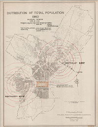
Philadelphia. Philadelphia City Planning Commission. Distribution of total population, 1940. Philadelphia, population 2,064,794 (1950). Philadelphia population within north-east blast area - 651,700 … within south-west blast area = 604,200. 1,256,900 = 60% of total. Total casualties, both blasts - 246,100 dead (12% of total). Injured living, both blasts = 211,000 injured (10% of total). 456,100 - 22% of total. | Not named | 1951 ca. |
Paper
49 x 39 in.
|
Philadelphia
Civil Defense. Concentric rings indicating damage and casualties from potential atomic bomb blast.
|