
Philadelphia Streets Department Surveys
2755 result(s). Showing results 1351 to 1400.
View page: 1 2 3 4 5 6 7 8 9 10 11 12 13 14 15 16 17 18 19 20 21 22 23 24 25 26 27 28 29 30 31 32 33 34 35 36 37 38 39 40 41 42 43 44 45 46 47 48 49 50 51 52 53 54 55 56 (Show all on one page)
| Identifer | Preview | Title | Surveyor | Date | Media / Size / Scale | Area / Map Features |
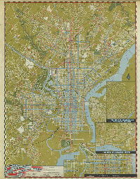
| FF-CivDef-16 |
|
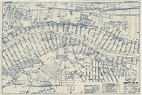
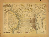
Street map of Philadelphia and vicinity, showing street car, bus, and subway-elevated lines. Philadelphia Transportation Company. April 1948. 7th Edition. | Not named | 1948 |
Paper
48 x 39 in.
|
Philadelphia and vicinity
Civil Defense. Mass transit. Shows two sets of concentric circles indicating potential atomic bomb blast zones - see FF-CivDef-15 for more details.
|
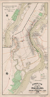
| FF-CivDef-18 |
|
Harbor Map of the City of Philadelphia, compiled by the Department of Wharves, Docks and Ferries. 1948. "Furnished to N.S.R.B. for use in Civil Defense problems" | Bonsall, Horace E. | 1948 |
Paper
44 x 23 in.
|
Philadelphia and vicinity
Legend includes: Municipal piers, Philadelphia Belt Line Railroad, Reading Company, Pennsylvania Railroad, Baltimore & Ohio Railroad
|
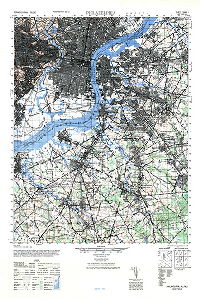
| FF-CivDef-19 |
|
Philadelphia, PA., N.J. Sheet 5963 I. A.M.S. Series V731. Army Map Service, Washington D.C. | Army Map Service | 1946 |
Paper
29 x 22 in.
1:50,000
|
Philadelphia and vicinity
Topography
|
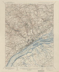
| FF-CivDef-20 |
|
United States Department of the Interior Geological Survey. Pennsylvania - Delaware - New Jersey. Chester Quadrangle. Edition of Jan. 1898, reprinted 1944. | USGS | 1898 |
Paper
20 x 17 in.
|
Chester, Pennsylvania and vicinity, including western edge of Philadelphia
Topography
|
| FF-CivDef-20 reverse |
|
The topographic maps of the United States [Reverse side of USGS maps FF-CivDef-20, FF-CivDef-21, and FF.CivDef-22] | USGS | 1944 ca. |
Paper
20 x 17 in.
|
No specific location
General information about topographic maps, with a key to symbols used
|
| FF-CivDef-21 |
|
United States Department of the Interior Geological Survey. Pennsylvania - New Jersey. Philadelphia Quadrangle. Edition of April 1898, reprinted 1943. | USGS | 1898 |
Paper
20 x 16 in.
|
Centered on Westville, N.J., with part of Philadelphia
Topography
|
| FF-CivDef-22 |
|
United States Department of the Interior Geological Survey. Pennsylvania - New Jersey. Germantown Quadrangle. Edition of Jan. 1899, reprinted 1946. | USGS | 1899 |
Paper
21 x 17 in.
|
Centered on Abington, Pa., with part of Philadelphia
Topography
|
| FF-CivDef-23 |
|
War Department, Corps of Engineers, U.S. Army. Delaware River, Philadelphia, PA., to Trenton, N.J., survey of 1932, in 11 sheets. Sheet 3. Ten Mile Point to Rancocas River. | USACE | 1932 |
Blueprint, Positive
14 x 21 in.
|
Delaware River front
Topography
|
| FF-CivDef-24 |
|
War Department, Corps of Engineers, U.S. Army. Delaware River, Philadelphia, PA., to Trenton, N.J., survey of 1932, in 11 sheets. Sheet 2. Bridesburg to Ten Mile Point. Revised to Aug. 10, 1949. | USACE | 1932 |
Blueprint, Positive
14 x 22 in.
|
Delaware River front
Topography
|
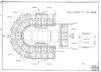
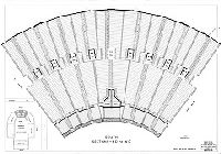
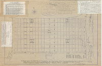
| FF-ConventionHall-01 |
|
Plan showing balcony seating arrangement, Convention Hall, Philadelphia. City Plans Division, Bureau of Engineering, Surveys & Zoning, Philadelphia. L. J. M. 1-4-38 | Not named | 1938 |
Tracing
34 x 48 in.
1 inch = 8 feet
|
West Philadelphia
Diagram of seating areas. Total capacity of upper and lower balconies: 6,305
|
| FF-ConventionHall-02 |
|
Philadelphia Convention Hall. City Plans Division, Bureau of Engineering, Surveys & Zoning, Philadelphia. | Not named | 1938 ca. |
Tracing
24 x 43 in.
|
West Philadelphia
Chart of seating by area. Total capacity of balconies, lower floor sections and stage sections: 9,217
|
| FF-ConventionHall-03 |
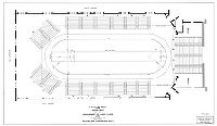
|
Layout of track for indoor meet. Arrangement of lower floor and stage seating. Philadelphia Convention Hall. City Plans Division, Bureau of Engineering, Surveys & Zoning, Philadelphia. L. J. M. 12-22-37 | Not named | 1937 |
Tracing
28 x 48 in.
1 inch = 8 feet
|
West Philadelphia
Seating arrangement around track.
|
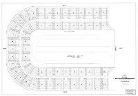
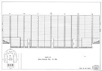
| FF-JFK-01 |
|
John F. Kennedy Stadium [General Summary] Sheet No. 1 of 7 sheets. Plans and Registry Division, Bureau of Engineering, Surveys, Zoning. October '36. Revised [to] Aug. 1963 | Not named | 1963 |
Tracing
36 x 52 in.
|
South Philadelphia. Broad St. at Terminal Ave.
Diagram of seating areas, and text giving total seating capacity: 99,004
|
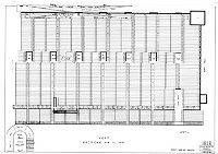
| FF-JFK-02 |
|
[John F. Kennedy Stadium] North. Sections NA to NG. Sheet No. 2 of 7 sheets. Plans and Registry Division, Bureau of Engineering, Surveys, Zoning. October '36. Revised [to] Dec. 1959 | Not named | 1959 |
Tracing
36 x 52 in.
|
South Philadelphia. Broad St. at Terminal Ave.
Diagram of seating areas
|
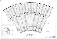
| FF-JFK-03 |
|
[John F. Kennedy Stadium] West Sections WN to WT. Sheet No. 3 of 7 sheets. Plans and Registry Division, Bureau of Engineering, Surveys, Zoning. October '36. Revised [to] Aug. 1963 | Not named | 1963 |
Tracing
36 x 52 in.
|
South Philadelphia. Broad St. at Terminal Ave.
Diagram of seating areas
|
| FF-JFK-04 |
|
[John F. Kennedy Stadium] Southwest Sections - WE to WM. Sheet No. 4 of 7 sheets. Plans and Registry Division, Bureau of Engineering, Surveys, Zoning. October '36. Revised [to] Dec. 1959 | Not named | 1959 |
Tracing
36 x 52 in.
|
South Philadelphia. Broad St. at Terminal Ave.
Diagram of seating areas
|
| FF-JFK-05 |
|
[John F. Kennedy Stadium] South Sections - ED to WD. Sheet No. 5 of 7 sheets. Plans and Registry Division, Bureau of Engineering, Surveys, Zoning. October '36. Revised [to] Dec. 1959 | Not named | 1959 |
Tracing
36 x 52 in.
|
South Philadelphia. Broad St. at Terminal Ave.
Diagram of seating areas
|
| FF-JFK-06 |

|
[John F. Kennedy Stadium] Southeast Sections - EE to EM. Sheet No. 6 of 7 sheets. Plans and Registry Division, Bureau of Engineering, Surveys, Zoning. October '36. Revised [to] Dec. 1959 | Not named | 1959 |
Tracing
36 x 52 in.
|
South Philadelphia. Broad St. at Terminal Ave.
Diagram of seating areas
|
| FF-JFK-07 |

|
[John F. Kennedy Stadium] East Sections EN to ET. Sheet No. 7 of 7 sheets. Plans and Registry Division, Bureau of Engineering, Surveys, Zoning. October '36. Revised [to] Aug. 1963 | Not named | 1963 |
Tracing
36 x 52 in.
|
South Philadelphia. Broad St. at Terminal Ave.
Diagram of seating areas
|
| FF-JFK-08 |
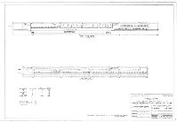
|
John F. Kennedy Stadium Press Box. Seat & Booth Identification Plan. Authorized by ordinance of Council, approved May 13, 1947. Seelye, Stevenson & Value, Consulting Engineers, 101 Park Ave., New York, N.Y. Drawing No. P4 of 4, Date, Sept. 23, 1948 … Revised [to] Sept. 9, 1960 | Not named | 1960 |
Tracing
25 x 36 in.
|
South Philadelphia. Broad St. at Terminal Ave.
Diagram of press box with text detailing seating capacity: 346
|
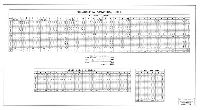
| FF-JFK-09 |
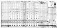
|
John F. Kennedy Stadium. Total seating capacity exclusive of Press Box: 98,604. Plans & Registry Division, Bureau of Engineers, Surveys, Zoning, October 1936. Revised [to] Aug. 1963. | Not named | 1963 |
Tracing
30 x 60 in.
|
South Philadelphia. Broad St. at Terminal Ave.
Table of seating by section
|
| FF-Maps 1762 |
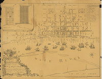
|
Philadelphia 100 years ago. "To the Mayor Recorder Aldermen Common Council and Freemen of Philadelphia this plan of the improved part of the City surveyed and laid down by the late Nicholas Scull Esq. Surveyor General of the Province of Pennsylvania is humbly inscribed by the Editors. [November 1858 republication, from Joseph H. Bonsall and Samuel L. Smedley, of 1762 map by Matthew Clarkson and M. Biddle] | Scull, Nicholas | 1762 |
Paper
21 x 27 in.
|
Philadelphia. Bounded by Delaware River to 8th St., Vine to South Sts.
Dock Creek, named wharves, important buildings listed, built-up areas shaded, sailing ships on Delaware River, Windmill Island
|
| FF-Maps 1776 |
|
1776. To the citizens of Philadelphia this plan of the City and its environs is respectfully dedicated by the Editor. 1926. Compliments of the Colonial Trust Company, Philadelphia. [Reproduction of a map made by P. C. Varle in 1794; one original is in collection of Library Company of Philadelphia] | Varle, P. C. | 1794 |
Paper
21 x 28 in.
|
Philadelphia and neighboring municipalities, including Kensington, Southwark, Passyunk, West Philadelphia, Spring Garden, etc.
Streams and valleys, extent of development shown by shading, suburban buildings located and owners named, key to important buildings in City proper.
|
| FF-Maps Blockley |

|
A connected draft showing the outlines of tracts of land found on record, situated in Blockley Township, Philadelphia County, the warrants, surveys, returns and patents bearing date respectively as above set forth, constructed from the original drafts and records remaining on file in the Department of Internal Affairs of Pennsylvania... | Not named | 1938 |
Paper
18 x 18 in.
1 inch = 50 rods
|
West Philadelphia, Blockley Township
Original land ownership
|
| FF-Maps Consolidation |

|
Map showing districts, boroughs and townships incorporated in the consolidation of Philadelphia in 1854 | Not named | 1854 |
Paper
38 x 30 in.
|
Philadelphia
Original municipalities in Philadelphia County
|
| FF-Maps Consolidation annotated |
|
Map showing districts, boroughs and townships incorporated in the consolidation of Philadelphia in 1854. | Masterson, ? | 1932 |
Paper
36 x 29 in.
|
Philadelphia
Annotations showing dates of Acts of Assembly that created these municipal entities.
|
| FF-Maps Creeks1971 |
|
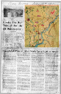
Creeks that run through the life of Philadelphia. Wissahickon flows in glory while some fight to survive. [Article by James S. Smart, from Philadelphia Sunday Bulletin, April 18, 1971, with accompanying map of historic streams in Philadelphia] | Not named | 1971 |
Paper
23 x 16 in.
|
Philadelphia
Map showing historic streams
|
| FF-Maps Dripps ByberryMoreland |
|
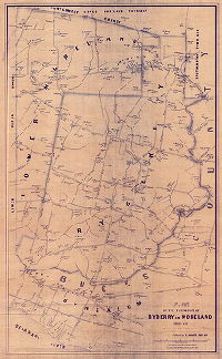
Plan of the townships of Byberry and Moreland, Phila. Co'y., by J. C. Sidney, Surveyor. Published by M. Dripps, Phila. 1849. Lith'y. of A. Kollner - H. Camps Lith. Press, Phoenix block, Phila. Copied by H. M. N., 4th Survey District, Feb'y. 1932 | Sidney, J. C. | 1849 |
Blueprint
40 x 25 in.
6 inches = 320 perches or 1 mile
|
Byberry and Moreland Townships, and adjacent sections of Bucks and Montgomery County
Poquessing Creek and tributary streams, including Byberry Creek and Bloody Run, Pennypack Creek tributaries, mill races, mill ponds, building footprints including factories, property owners with acreage, village names
|
| FF-Maps Dripps LowerDublin |
|
Plan of the Township of Lower Dublin by J. C. Sidney, 80 Walnut St., Philada. Copied by H. M. N. 1932, 4th Survey District. Probable date 1848. | Sidney, J. C. | 1848 ca. |
Blueprint
38 x 26 in.
6 inches = 320 perches or 1 mile
|
Lower Dublin Township
Pennypack Creek and tributary streams, mill races, mill ponds, building footprints including factories, property owners with acreage, village names
|
| FF-Maps Dripps Roxborough |
|
Plan of the Township of Roxborough with the property holders' names &c. Manayunk by Jno. Levering. Surv. Published by M. Dripps, 1848. | Levering, John | 1848 |
Blueprint
23 x 37 in.
|
Roxborough and Manayunk
Topography (shown by hachure marks), Wissahickon Creek and tributaries, property owners and names of properties, building footprints, Schuylkill River, Flat Rock Dam, canal and towpath
|
| FF-Maps Germantown1751 |
|
Copy of map in Road Docket, Philadelphia, showing roads in Germantown about 1751. (Reverse: 1968 Thrill Show poster) | Not named | 1751 |
Blueprint
21 x 13 in.
1 inch = 100 perches
|
Germantown Township
Old roads with modern names
|
| FF-Maps Hills1796 1881Reprint |

|
This plan of the city of Philadelphia and its environs (shewing the improved parts) is dedicated to the Mayor, Aldermen and Citizens thereof by their most obedient servant, John Hills, Surveyor and Draughtsman. May 30th, 1796. | Hills, John | 1796 |
Paper
29 x 40 in.
|
Philadelphia
Topography (shown by hachure marks), streams, ponds, building footprints, brickyards, and many other features
|
| FF-Maps Holme PA |
|
Map of improved part of Pensilvania [Pennsylvania] in America, divided into counties, townships and lotts. | Holme, Thomas | 1681 |
Paper
17 x 23 in.
|
Pennsylvania, early settlements
Property owners, rivers and streams, municipal divisions
|
| FF-Maps Holme Phila1 |

|
A portraiture of the City of Philadelphia in the Province of Pennsylvania. | Holme, Thomas | 1682 |
Tracing
16 x 22 in.
|
Philadelphia
Fairmount, original squares, Dock Creek, Pegg's Run
|
| FF-Maps Holme Phila2 |
|
Portraiture of the City of Philadelphia in the Province of Pennsylvania in America. By Thomas Holme, Surveyor General | Holme, Thomas | 1682 |
Paper
14 x 22 in.
|
Philadelphia
Positive blueprint copy, annotated with handwritten comments and photocopies taped on, providing much background information relating to the plan.
|
| FF-Maps Noll1888 |
|
Noll's new official guide map of Philadelphia from the latest official surveys & records, showing elevations lines, ward lines, streets, roads, rivers &c. & steam railways, public & private institutions, places of interest, &c. Published by E. P. Noll & Co. ... 1888 | Noll, E. P. | 1888 |
Paper
36 x 30 in.
1 inch = 2000 feet
|
Philadelphia and vicinity
Topography (25' contours), streams, marshland, railroads, building footprints, parks, and many other features
|
| FF-Maps Noll1889 13th15thPRWCO |
|
Noll's new official guide map of Philadelphia from the latest official surveys & records….1889. Published by E. P. Noll & Co. [Route of 13th and 15th Street Passenger Railway Co. traced on this map in colored ink] | Noll, E. P. | 1889 |
Paper
37 x 27 in.
1 inch = 2000 feet
|
Philadelphia and vicinity
Creeks, city institutions, wharves, railroads, street railway, and many other features
|
| FF-Maps Noll1889 HMFPPRWCO |

|
Noll's new official guide map of Philadelphia from the latest official surveys & records….1889. Published by E. P. Noll & Co. [Route of Hestonville, Mantua and Fairmount Passenger Railway Co. traced on this map in colored ink] | Noll, E. P. | 1889 |
Paper
40 x 27 in.
1 inch = 2000 feet
|
Philadelphia and vicinity
Creeks, city institutions, wharves, railroads, street railway, and many other features
|
| FF-Maps Noll1889 RAPRWCO |
|
Noll's new official guide map of Philadelphia from the latest official surveys & records….1889. Published by E. P. Noll & Co. [Route of Ridge Avenue Passenger Railway Co. traced on this map in colored ink] | Noll, E. P. | 1889 |
Paper
40 x 27 in.
1 inch = 2000 feet
|
Philadelphia and vicinity
Creeks, city institutions, wharves, railroads, street railway, and many other features
|
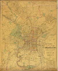
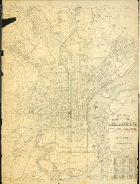
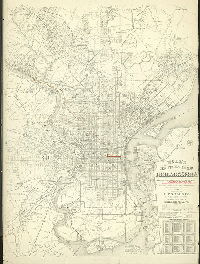
| FF-Maps Smith1921 |

|
Map of Philadelphia, Camden and vicinity, compiled from City Plans and personal surveys, published by Elvino V. Smith. C.E., 1039 Walnut St., Phila., Pa. | Smith, Elvino V. | 1921 |
Mounted
54 x 38 in.
1 inch = 2000 feet
|
Philadelphia and vicinity
Creeks, city institutions, wharves, railroads, street railway, and many other features
|
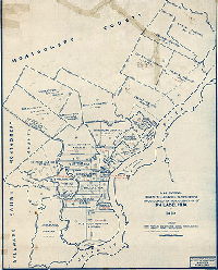
| FF-Maps Wards 1961 |
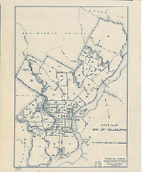
|
Ward Map, City of Philadelphia. City Plans Division, Bureau of Surveys & Design, Dept. of Streets, Philadelphia. [Last revision Aug. 1, 1961] | Not named | 1961 |
Blueprint
14 x 18 in.
|
Philadelphia
Ward boundaries
|
| FF-Misc-09 NEPhila |
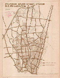
|
Proposed major street system, N.E. [Northeast] Philadelphia. Study. | Not named | 1950 ca. |
Paper
38 x 30 in.
|
Northeast Philadelphia
Shows proposed expressway system for Northeast Philadelphia
|
| FF-Misc-10 |
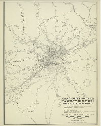
|
Common carrier passenger transportation routes in the Philadelphia region. Philadelphia City Planning Commission, November 1946. Source of data: Information supplied by operating companies. | Not named | 1946 |
Paper
35 x 27 in.
|
Philadelphia and vicinity
Shows all named passenger railroad stations, suburban and interurban electric railways, bus lines, trolley coach lines, ferry and steamboat lines.
|
| FF-Misc-11 |
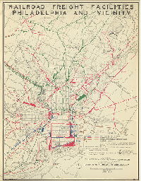
|
Railroad freight facilities, Philadelphia and vicinity. Prepared by Philadelphia City Planning Commission from information supplied by the railroads. Printed and distributed by Chamber of Commerce of Philadelphia. June 1949 | Not named | 1949 |
Paper
45 x 35 in.
|
Philadelphia and vicinity
Baltimore and Ohio Railroad, Pennsylvania Railroad, Pennsylvania -Reading Seashore Lines, and Reading Company
|
| FF-Parks Cobbs1 |
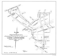
|
Plan of registered owners of properties to be taken for the extention [sic: extension] of Cobbs Creek Park. Ordinance dated Jan. 25, 1917. 34th Ward. Registry Division, Bureau of Surveys. P-5-16 | Cornish, Stacy H., delineator | 1917 |
Tracing
22 x 23 in.
1 inch = 200 feet
|
West Philadelphia. Cobb's Creek Park
Color in original; blue outline of Park area shows up as shading in this scan
|
| FF-Parks Cobbs2 |
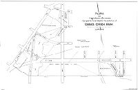
|
Plan of registered owners of properties to be taken for the extention [sic: extension] of Cobbs Creek Park. Ordinance dated Jan. 25, 1917. 34th Ward. Registry Division, Bureau of Surveys. | Still, W. W. | 1917 |
Tracing
30 x 45 in.
1 inch = 100 feet
|
West Philadelphia. Cobb's Creek Park
Color in original; blue outline of Park area shows up as shading in this scan
|
| FF-Parks Fernhill1 |

|
Topographical plan of Fernhill Park | Not named | 1924 |
Blueprint
39 x 64 in.
|
Fernhill Park. Bounded by Abbotsford Rd., W. Washington Ave., Roberts Ave. and Norris St.
Topography, building footprints
|
| FF-Parks Fernhill2 |

|
Plan of Fernhill Park showing properties and buildings thereon erected on streets bounding same. 22nd and 38th Wards, Phila. … Made for the use of the Commissioners of Fairmount Park [Survey returned March 7, 1916] | Wagner, Joseph C. | 1916 |
Blueprint
27 x 36 in.
1 inch = 100 feet
|
Fernhill Park. Bounded roughly by Clapier St., Pulaski Ave., Roberts Ave. and Wissahickon Ave.
Property lines and owners, deed information added, building footprints with material noted, Midvale Branch of the Connecting Railway.
|
| FF-Parks Harrowgate |

|
Plan of Harrowgate Park, 25th Ward, Phila. [Survey returned Nov. 28, 1893; ordinance March 28, 1894] [From City Plan 160, also numbered 160-9] | Brinton, Walter | 1893 |
Mounted
24 x 17 in.
|
Harrowgate Park, bounded by Kensington Ave., Tioga St., Jasper St. and Kettlewell St.
Shows proposed park, with "11 brick houses" within the park property.
|
| FF-Parks Lighting Cedar |

|
Plan of Cedar Park, 46th Ward, Philadelphia. Made for Lighting Survey, Department of Public Works. | Jones, Henry L.; Hyde, George N. | 1933 |
Paper
10 x 12 in.
1 inch = 40 feet
|
West Philadelphia. Cedar Park, bounded by 50th St., Catharine St. and Baltimore Ave.
Shows location of electric lights, trees, and park paths and benches.
|