
Philadelphia Streets Department Surveys
2755 result(s). Showing results 101 to 150.
View page: 1 2 3 4 5 6 7 8 9 10 11 12 13 14 15 16 17 18 19 20 21 22 23 24 25 26 27 28 29 30 31 32 33 34 35 36 37 38 39 40 41 42 43 44 45 46 47 48 49 50 51 52 53 54 55 56 (Show all on one page)
| Identifer | Preview | Title | Surveyor | Date | Media / Size / Scale | Area / Map Features |
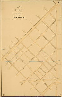
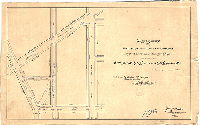
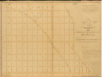
| 018-03 MTD |
|
Plan of revision of part of Fifth Section, Twenty-third Ward Philadelphia. [Approved Board of Surveyors March 21, 1870] | Not named | 1870 |
Mounted
53 x 34 in.
|
23rd Ward, 5th Section. Bounded by Allegheny Ave., Kensington Ave., Lehigh Ave. and Fillmore St.
Stream, curb elevations
|
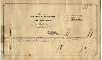
| 018-06 MTD |

|
Plan of the revision of lines and grades on the Fifth Section of the Twenty-Fifth Ward (late Twenty-third Ward) Philadelphia [Ordinance July 5, 1877; confirmed Nov. 19, 1877] | Not named | 1877 |
Mounted
42 x 54 in.
|
25th Ward, 5th Section. Bounded by A St., Fillmore St., Allegheny Ave, Frankford Ave. and Lehigh Ave.
Topography, Gunner's Run and tributary streams, railroad
|
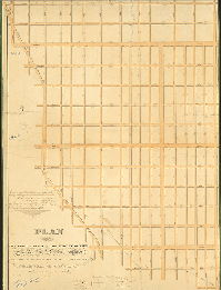
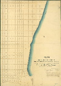
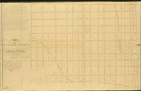
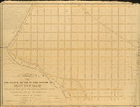
| 019-01 HP |

|
Topography and grade regulation of Plan Number 19 [Ordinance Dec. 31, 1875; survey returned Dec. 1877; no confirmation date. This plan covers City Plans 342, 343 and 348, and overlaps slightly with 161, 167 and 169. ] | Hancock, George W. | 1877 |
Mounted
48 x 115 in.
1 inch = 100 feet
|
West Philadelphia. Bounded by Lancaster Ave. to Cobbs St., City Ave. to Sellers La. and Haddington Ave.
Topography, streams, Indian Creek, mill races, mill ponds, building footprints
|
| 019-02 HP |
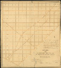
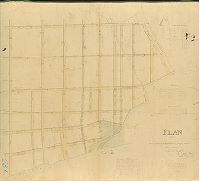
|
Plan showing the revision of the lines and grades of 69th St. from Lebanon Ave. to City Ave. and to place on the City Plan Woodbine and Overbrook Aves. from 66th to 69th Sts, and to revise such other streets as may be affected thereby. [Ordinance April 6, 1897; survey returned July 17, 1899; confirmed Aug. 21,1899] | Johnson, Joseph | 1899 |
Mounted
43 x 36 in.
|
West Philadelphia. Bounded roughly by 66th and 73rd Sts., and Lebanon and City Aves.
Topography, Indian Creek, mill races
|
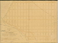
| 019-03 HP |
|
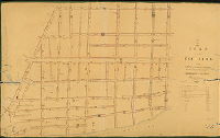
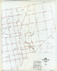
Plan of the Twelfth Section of the survey of the late Township of Blockley made in pursuance of two Acts of the Assembly of the State of Pennsylvania approved respectively on the 3rd of April A.D. 1851 and the 13th of May, A. D. 1856. Surveyed and returned to the Board of Surveyors of the City of Philadelphia 12 mo. 7th, 1859 by Francis Lightfoot. | Lightfoot, Francis | 1859 |
Mounted
52 x 57 in.
|
West Philadelphia, Blockley Township, 12th Section. Cobbs Creek to 66th St.; City Ave. to Arch St.
Creeks, mill buildings
|
| 019-04 HP |
|
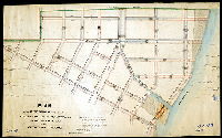
Plan for revising the curb lines of Lansdowne Ave. from 63rd St. to County Line and 66th and 67th Sts. between Haverford St. and Lansdowne Ave. so as to increase the width of the cartway to 36 feet. [Ordinance Jan. 28, 1907; no confirmation date] | Johnson, Joseph | 1907 |
Mounted
33 x 72 in.
|
West Philadelphia
Curb elevations
|
| 019-05 HP |

|
Plan for placing on City Plan Haddington Street of the width of 40 ft. from 66th to 67th St. [Ordinance May 19, 1904; survey returned and confirmed Sept. 12, 1904] | Johnson, Joseph | 1904 |
Mounted
12 x 18 in.
|
West Philadelphia
Curb elevations
|
| 019-06 HP |
|
Plan showing the revision of the lines and grades of that portion of the City Plan bounded by 63rd St., 64th St., Jefferson St. and Lebanon Ave. [Ordinance June 12, 1899; confirmed Nov. 20, 1899] | Johnson, Joseph | 1899 |
Mounted
13 x 20 in.
|
West Philadelphia
Curb elevations
|
| 019-07 HP |
|
Plan showing the revision of grades of Malvern Avenue between 63rd St. & 64th St. [Ordinance Dec. 10, 1898; confirmed June 5, 1899] | Johnson, Joseph | 1898 |
Mounted
11 x 17 in.
|
West Philadelphia
Curb elevations
|
| 020-01 HP |

|
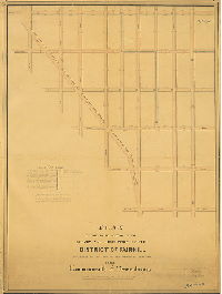
Plan of the Fourth Section of the survey and regulation of the District of Fair-hill [Fairhill], agreeably to an Act of the General Assembly of the Commonwealth of Pennsylvania approved the sixteenth day of March A.D. 1847. Surveyed and returned 2nd mo. 21st 1848 by Joseph Fox, Henry Haines. Filed April 4th, 1848 | Fox, Joseph; Haines, Henry | 1848 |
Mounted
48 x 36 in.
1 inch = 100 feet
|
Fairhill, 4th Section. Bounded by Huntington to Clearfield Sts., 5th to 11th Sts.
Mansion at northeast corner 7th & Somerset Sts., sewers
|
| 020-02 HP |
|
Plan of the First Section of the survey of the Township of the Northern Liberties, agreeably to an Act of the General Assembly of the Commonwealth of Pennsylvania, passed the third day of May A.D. 1832. Drawn by R. M. Sexton, surveyed and returned August 10th, 1839, by John Foulkrod, R. M. Sexton. | Foulkrod, John and Sexton, R. M. | 1839 |
Mounted
49 x 37 in.
1 inch = 10 perches, c. 166 feet
|
Northern Liberties, 1st Section. Bounded by Front St. to Germantown Ave., Diamond to Ontario Sts.
Boundary line of District of Kensington
|
| 021-01 HP |
|
Plan of the Second Section of the survey of the Township of the Northern Liberties, agreeably to an Act of the General Assembly of the Commonwealth of Pennsylvania, passed the third day of May A.D. 1832. Surveyed and returned September 17th, 1840, by John Foulkrod, R. M. Sexton. Filed September 18, 1840 [Note in pencil: "See revised plan," probably 021-2_HP] | Foulkrod, John and Sexton, R. M. | 1840 |
Mounted
57 x 51 in.
1 inch = 125 feet (0.4 inch = 50 feet)
|
Northern Liberties, 2nd Section. Bounded by Front St. to Frankford Ave. and O St., Norris to Ontario Sts.
Old roads, "bearings and lengths for railroad rights of way", penciled annotations
|
| 021-02 HP |

|
Plan of the Second Section of the survey of the Township of the Northern Liberties, agreeably to an Act of the General Assembly of the Commonwealth of Pennsylvania, passed the third day of May A.D. 1832. Surveyed and returned May 30th, 1843, by John Foulkrod, Joseph Fox. Filed June 1st,1843 | Foulkrod, John and Fox, Joseph | 1843 |
Mounted
47 x 42 in.
1 inch = 250 feet
|
Northern Liberties, 2nd Section. Bounded by Front to Tulip Sts., Norris St. to Erie Ave.
Street lines, old roads
|
| 022-01 HP |
|
Plan of the Third Section of the survey of the Township of the Northern Liberties, agreeably to an Act of the General Assembly of the Commonwealth of Pennsylvania, passed the third day of May anno Domini, 1832. Surveyed and returned November 30th, 1844, by Joseph Fox, Henry Haines. | Fox, Joseph; Haines, Henry | 1844 |
Mounted
62 x 44 in.
1 inch = 200 feet
|
Northern Liberties, 3rd Section. Bounded by Delaware River to Tulip St., Erie Ave. to Norris St.
Kensington District boundary, penciled annotations, ECG on reverse
|
| 023-01 HP |
|
Plan of the survey of a section of the Second Division of the Kensington District of the Northern Liberties. Surveyed and returned by George S. Krimmel, October 22nd, 1824. | Kimmel, George C. | 1824 |
Mounted
39 x 44 in.
1 inch = 88 feet
|
Kensington District, 2nd Division. Bounded by Belgrade St. to Delaware River, Gunner's Run to Oxford St.
Gunner's Run, Palmer and Norris property lines, benchmark buildings, sewers, inlets, wetlands, modern street names in pencil
|
| 024-04 HP |
|
Plan of the revision of parts of the plans of the survey and regulation of the First and Second Divisions of the Kensington District, Philada. County. Revised and returned Feby 3rd 1834 by B. Moore | Moore, Benjamin | 1834 |
Mounted
30 x 49 in.
|
Kensington District, 1st and 2nd Divisions. Bounded by Belgrade St. to Delaware River, Frankford Ave. o Wood St. [Susquehanna Ave.]
Modern street names in pencil, sewers and inlets, benchmark buildings, low water mark, curb heights
|
| 025-01 HP |
|
Plan of the Sixth Division including the revision of part of the Second Division of the survey and regulation of the Kensington District. Surveyed by B. Moore. Returned Feby 5th 1839. | Moore, Benjamin | 1839 |
Mounted
25 x 40 in.
1 inch = 80 feet
|
Kensington District, 6th Division and part of 2nd. Bounded by northeastern boundary of the district, Wood [Susquehanna] St., and Delaware River
Gunner's Run, sewers and inlets, tidal marshland
|
| 025-02 HP |

|
Plan of the revision of the survey & regulation of the 6th Division and part of the 5th, of the Kensington District. Returned Jany 7th 1845, by Benj. Moore. | Moore, Benjamin | 1845 |
Mounted
26 x 39 in.
1 inch = 80 feet
|
Kensington District, 6th Division and part of 5th. Bounded by Cedar to Beech Sts., Cumberland St. to Wood [Susquehanna] St.
Norris's line, Gunner's Run (original course and new course of Canal), culvert street, sewers & inlets, wetlands
|
| 026-01 HP |
|
Plan of the First Section of the survey of Penn Township, agreeably to an Act of the General Assembly of the Commonwealth of Pennsylvania, passed the third day of May anno Domini One thousand eight hundred and thirty-two. Surveyed and returned Jan. 2nd 1838, Joseph Fox, Philip M. Price. | Fox, Joseph; Price, Philip M. | 1838 |
Mounted
38 x 61 in.
1 inch = c. 200 feet
|
Penn Township, 1st Section. Bounded by Poplar St. to Susquehanna Ave., 6th St. to 24th St.
Turners Lane, Timber Lane, Stump Lane, Masters Lane, Islington Lane; Philadelphia, Germantown and Norristown Railroad, outline of Girard College site, benchmark building
|
| 027-01 HP |
|
Plan of the Second Section of the survey of Penn Township, agreeably to an Act of the General Assembly of the Commonwealth of Pennsylvania, passed the third day of May anno Domini One thousand eight hundred and thirty-two. Surveyed and returned Jan. 2nd 1838, Joseph Fox, Philip M. Price. | Fox, Joseph; Price, Philip M. | 1838 |
Mounted
38 x 52 in.
1 inch = c. 200 feet
|
Penn Township, 2nd Section. Bounded by Poplar St, to Susquehanna Ave., 24th St. to Schuylkill River
Islington Lane, Mount Pleasant St., Mifflin Lane, Girard College site
|
| 027-01 HP copy |
|
Plan of the Second Section of the survey of Penn Township, agreeably to an Act of the General Assembly of the Commonwealth of Pennsylvania, passed the third day of May anno Domini One thousand eight hundred and thirty-two. Surveyed and returned Jan. 2nd 1838, Joseph Fox. Drawn by R. M. Sexton, Asst. Surveyor | Fox, Joseph | 1838 |
Mounted
39 x 52 in.
|
Penn Township, 2nd Section. Bounded by Poplar St, to Susquehanna Ave., 24th St. to Schuylkill River
Islington Lane, Mount Pleasant St., Mifflin Lane, Girard College site
|
| 028-01 HP |

|
Plan of the Fourth Section of the survey of Penn Township, agreeably to an Act of the General Assembly of the Commonwealth of Pennsylvania, passed the third day of May A.D. 1832. Surveyed and returned 1st Mo 12th 1841 by Joseph Fox, Surveyor. | Fox, Joseph | 1841 |
Mounted
34 x 51 in.
1 inch = 200 feet
|
Penn Township, 4th Section. Bounded by Susquehanna to Allegheny Aves., 23rd St. to Schuylkill River
Lamb Road, Nicetown Road, Hart Road; foot bridge at East Falls (possibly suspension bridge) over Schuylkill River, at foot of Allegheny Ave., Laurel Hill Cemetery
|
| 029-01 HP |
|
Plan of the Third Section of the survey of Penn Township, agreeably to an Act of the General Assembly of the Commonwealth of Pennsylvania, passed the third day of May A.D. 1832. Surveyed & returned 9 mo. 20th 1838. Joseph Fox, Surveyor. | Fox, Joseph | 1838 |
Mounted
38 x 52 in.
1 inch = 180 feet
|
Penn Township, 3rd Section. Bounded by Susquehanna Ave. to West Moreland (Westmoreland) St., 23rd St. to Germantown Turnpike
Islington Street, Falls Road, Lamb Road, Rising Sun Lane, Turners Lane, [obsolete] Germantown Road; Philadelphia, Germantown and Norristown Railroad; Township Line Road
|
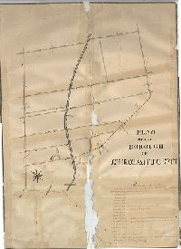
| 030-01 HP |

|
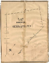
Map of the Borough of Germantown compiled by order of Councils from actual surveys by J. C. Trautwine and S. W. Mifflin, Civil Engineers, 1849. Drawn by A. H. Reitz | Trautwine, J. C.; Mifflin, S. W. | 1849 |
Mounted
68 x 50 in.
|
Germantown Borough
Wingohocking Creek, streams, mill ponds, mill races, "magnetic median"
|
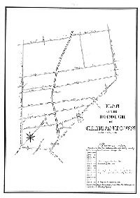
| 030-01 HP tracing |
|
Map of the Borough of Germantown compiled by order of Councils from actual surveys by J. C. Trautwine and S. W. Mifflin, Civil Engineers, 1849. Drawn by A. H. Reitz. | Trautwine, J. C.; Mifflin, S. W. | 1849 |
Tracing
64 x 51 in.
1 inch = 230 feet
|
Germantown. Bounded by Carpenter Lane to Gorgas Lane and Wister St. to Roberts Ave.
Paper Mill Run, Monashony [Monoshone] Creek, Wingohocking Creek, mill races, mill ponds, no color except red annotations; redrawn by A. H. Rietz, 19th c.
|
| 030-02 HP |
|
Plan of a proposed eighty feet wide street located in the Borough of Germantown by order of the Town Council July the 17th, 18th, 21st & 22nd 1851. By Joseph King, Jr., Borough Surveyor | King, Joseph, Jr. | 1851 |
Paper
18 x 54 in.
1 inch = 250 feet
|
Germantown, Chelten Avenue. Wissahickon Ave. to Wistar St.
Transcription on back with resolution of Germantown Borough, notes of 1852 amendment
|
| 030-03 HP |
|
Plan of a proposed eighty feet wide street located in the Borough of Germantown, County of Philadelphia by order of the Town Council, July the 17th, 18th, 21st & 22nd 1851. By Joseph King, Jr., Borough Surveyor | King, Joseph, Jr. | 1851 |
Paper
9 x 54 in.
1 inch = 250 feet
|
Germantown, Chelten Avenue. Wissahickon Ave. to Wistar St.
Paper Mill Run [Monoshone Creek) and tributary stream; Wingohocking Creek tributaries, mill pond, dam
|
| 030-x HP |
|
Plan of the Borough of Germantown, Surveyed March 1839 (Incomplete] | King, J.; Wister, C. E. | 1839 |
Paper
21 x 16 in.
|
Germantown Borough
Wingohocking Creek and Falls Run [Dobson's Run] and tributaries, Paper Mill Run, building footprints
|
| 030-y HP |
|
Plan of the Borough of Germantown, surveyed March 1839 by J. King and C. E. Wister | King, J.; Wister, C.E. (probably) | 1839 |
Paper
23 x 17 in.
|
Germantown Borough
Building footprints
|
| 030-y HP tracing |
|
Plan of the Borough of Germantown, surveyed March 1839 by J. King and C. E. Wister | King, J.; Wister, C. E. | 1839 |
Tracing
|
Germantown Borough
Street lines, streams at street crossings, building footprints
|
| 031-01 HP |

|
Plan of the Sixth Section of the survey of Penn Township, agreeably to an Act of the General Assembly of the Commonwealth of Pennsylvania, passed the third day of May AD 1832, surveyed and returned 1st mo. 19th 1841 by Joseph Fox. [Attachment not scanned: letter from Joseph Siddall, 1856, regarding changes, in plan, refers to St. James the Less] | Fox, Joseph | 1841 |
Mounted
35 x 51 in.
1 inch = 200 feet
|
Penn Township, 6th Section. Bounded by Allegheny Ave., Schuylkill River, Roxborough Township and Germantown Township boundaries
Footbridge over Schuylkill River
|
| 032-01 HP |

|
Plan of the Fifth Section of the survey of Penn Township, agreeably to an Act of the General Assembly of the Commonwealth of Pennsylvania, passed the third day of May AD 1832, surveyed and returned 9 mo. 20 1839 by Joseph Fox. | Fox, Joseph | 1839 |
Mounted
39 x 38 in.
1 inch = 200 feet
|
Penn Township, 5th Section. Bounded by 12th St., Germantown Ave., 26th St., Allegheny Ave. and Bristol St.
Township Line Road, Nicetown Lane, Rising Sun Lane, older version of Germantown Road; Philadelphia, Germantown and Norristown Railroad
|
| 033-01 HP |

|
Plan exhibiting the curb heights, water courses and culverts in the Northern Section of Passyunk together with the location of certain streets made in pursuance of Acts of Assembly passed June 21st, 1839 and by Saml. H. Kneass, Civil Engineer. Approved by Commissioners October 21st, 1840. Confirmed Decr. 12th, 1840. | Kneass, Samuel H. | 1840 |
Mounted
28 x 49 in.
1 inch = 160 feet
|
South Philadelphia. Passyunk, Northern Section. Bounded by 17th St. to Schuylkill River, South St. to Oakford St. below Federal St.
Naval Asylum, Arsenal, Schuylkill & Delaware Canal, Irish Tract, Grover Ave., old streets indicated, wharves, wetlands, sewers, note about Federal St. culvert
|
| 033-01 HP tracing |

|
Plan exhibiting the curb heights, water courses and culverts in the Northern Section of Passyunk together with the location of certain streets made in pursuance of Acts of Assembly passed June 21st, 1839 and by Saml. H. Kneass, Civil Engineer. Approved by Commissioners October 21st, 1840. Confirmed Decr. 12th, 1840. | Kneass, Samuel H. | 1840 |
Tracing
28 x 49 in.
1 inch = 160 feet
|
South Philadelphia. Passyunk, Northern Section. Bounded by 17th St. to Schuylkill River, South St. to Oakford St. below Federal St.
Naval Asylum, Arsenal, Schuylkill & Delaware Canal, Irish Tract, Grover Ave., old streets indicated, wharves, wetlands, sewers, note about Federal St. culvert
|
| 034-01 HP |

|
Plan exhibiting the curb heights, water courses and culverts in the Southern Section of Passyunk together with the location of certain streets made in pursuance of Act of Assembly passed June 21st 1839 and by Saml. H. Kneass, Civil Engineer. Approved by Commissioners October 21st 1840. Confirmed Decr. 12th 1840 | Kneass, Samuel H. | 1840 |
Mounted
26 x 46 in.
1 inch = 160 feet
|
South Philadelphia. Passyunk, Southern Section. Bounded by Broad St. to Schuylkill and Delaware Canal, Oakford St. to Moore St.
Schuylkill & Delaware Canal and towpath, Buck Rd., Long Lane, old streets indicated, wharves, wetlands, sewers,
|
| 035-01 HP |
|
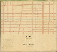
Plan of the Fourth Section of the survey and regulation of Kensington District approved by the Board of Commissioners May 17th 1852. Revised and returned 1852 by James P. Davis. [Attachment: typescript excerpt of 1852 Court approval] | Davis, James P. | 1852 |
Mounted
48 x 43 in.
1 inch = 500 feet
|
Kensington District, 4th Section. Bounded by Somerset to Diamond Sts., 2nd St. to Germantown Ave.
Fairhill Reservoir, sewers, inlets, curb elevations
|
| 035-01 HP attachment |
|
[Court approval of plan 035-01_HP] | 1852 |
Paper
|
Kensington District, 4th Section. Bounded by Somerset to Diamond Sts., 2nd St. to Germantown Ave.
Attachment
|
|
| 035-02 HP |
|
Plan of the Third Section of the survey and regulation of the District of Fair-hill [Fairhill] agreeably to an Act of the General Assembly of the Commonwealth of Pennsylvania passed the sixteenth day of March A.D. 1847. Surveyed and returned 10th Mo 20th 1847 by Joseph Fox, Henry Haines | Fox, Joseph; Haines, Henry | 1847 |
Mounted
48 x 35 in.
5.5 inches = 500 feet
|
Fairhill District, 3rd Section. Bounded by Diamond St. to Huntingdon St., 4th St. to Germantown Ave.
Culverts and sewers, curb heights
|
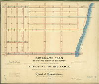
| 036-01 HP |
|
Plan of alterations & reestablished grades of the Fourth Section of the District of Richmond | Spain, Edward Livingston | 1853 |
Mounted
41 x 46 in.
1 inch = 100 feet
|
Richmond District, 4th Section. Bounded by Belgrade St. to Philadelphia and Trenton Railroad, Somerset St. to Westmoreland St.
Gunner's Run canal, sewers, curb elevations
|
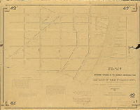
| 036-02 HP |

|
Plan of the revision of grades to conform to the bridges over Aramingo Canal in the Nineteenth Ward, City of Philadelphia. Made by authority of a resolution of Councils approved Feby 24th, 1857. Philadelphia, May 2nd 1857, James P. Davis, City Surveyor, 6th Dist. Approved by Board of Surveyors June 15th, 1857. Confirmed by Court December 8th, 1858. | Davis, James P. | 1857 |
Mounted
51 x 15 in.
1 inch = 100 feet
|
19th Ward. Aramingo Canal. Allegheny to Lehigh Aves., Tulip to Gaul Sts.
Aramingo Canal, sewers, curb elevations
|
| 036-x HP tracing |

|
Plan of the Third Division of the survey and regulation of the District of Richmond. Surveyed 9 mo 10th 1847 by Henry Haines and Joseph Fox | Haines, Henry; Fox, Joseph | 1847 |
Tracing
37 x 36 in.
1 inch = 100 feet
|
Bounded by Delware River to Belgrade St., Westmoreland St. to beyond Richmond St. to Williams St.
Delaware Avenue continued along shoreline
|
| 037-01 HP |

|
Plan of the Fourth Division of the survey and regulation of the District of Richmond, agreeably to an act of the General Assembly of the Commonwealth of Pennsylvania passed the Twenty-seventh day of February A.D. 1847 [Survey returned Sept. 10, 1847; confirmed by Court June 23, 1848] | Fox, Joseph; Haines, Henry | 1847 |
Microfilm Only
|
Richmond, 4th Division. Bounded by Emerald to West Sts., Westmoreland to Somerset Sts.
Curb elevations
|
| 037-02 HP |
|
Plan of re-established grades of portions of the Second & Fourth Sections of Richmond District. [Survey returned June 1, 1852; confirmed by Court Nov. 11. 1852] | Spain, Edward Livingston | 1852 |
Microfilm Only
|
Richmond, 4th and 2nd Sections
Curb elevations, sewers
|
| 038-01 HP |
|
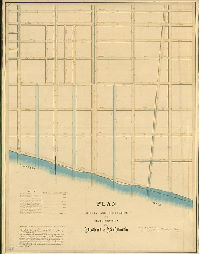
Plan of survey and regulation of the Sixth Section of the District of Richmond. Surveyed & returned May 21st 1851 by E. Livingston Spain, Surveyor | Spain, Edward Livingston | 1851 |
Mounted
55 x 42 in.
1 inch = c. 100 feet
|
Richmond District, 6th Section. Bounded by Salmon St. to Delaware River, Tioga St. to north of Pike St.
Three proposed canals, sewer, curbs
|
| 038-02 HP |
|
Duplicate plan of the Fifth Section of the survey and regulation of the District of Richmond recorded in place of the original misplaced or lost. By order of the Board of Commissioners of the said District by a resolution on the 2nd day of Nov. A.D. 1853. Made January 3rd 1854 by Edw. L. Spain. Surv. confirmed by the Court of Quarter Sessions, October 12th, 1850. | Spain, Edward Livingston | 1854 |
Mounted
35 x 42 in.
|
Richmond District, 5th Section. Bounded by Richmond St. to Delaware River, Tioga St. to Westmoreland St.
Sewers, canal
|
| 039-01 HP |

|
A plan of the Borough of Frankford, Philadelphia County, from actual survey in accordance with an Act of Assembly passed April 5, 1841. Surveyed and drawn by Isaac Shallcross. [Adopted by Council and inhabitants of Frankford, 5 April 1847; confirmed Nov. 13, 1847] | Shallcross, Isaac | 1847 |
Mounted
33 x 48 in.
1 inch = 200 feet
|
Frankford. Bounded by Frankford Creek, Little Tacony Creek, and Oxford Township line
Frankford Creek, Little Tacony Creek, many tributaries, a dozen public buildings named and outlined including schools, churches; dye works, mills, factories, property owners
|
| 040-01 HP |
|
Plan of the First Section of the survey of the Belmont Estate in the District of Belmont. Made in pursuance of the provisions of Section 20th of the Act of Assembly of the Commonwealth of Pennsylvania incorporating the District of Belmont, approved the 14th Day of April 1853. Surveyed & returned By Joseph Fox, Surveyor, Charles H. Fox and Saml. L. Smedley, Assists. 4th Mo, 1st 1854. Samuel L. Smedley, draftsman. | Fox, Joseph; Fox, Charles H.; Smedley, Samuel L. | 1854 |
Mounted
49 x 40 in.
1 inch = 100 feet
|
West Philadelphia. Belmont Estate, 1st Section, District of Belmont. Bounded by Schuylkill River to Belmont Ave., Columbia to Susquehanna Aves.
Columbia Railroad covered bridge, footprints of all buildings, old roads, proposed streets and subdivisions, sewers
|
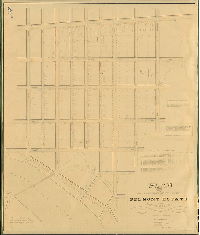
| 040-02 HP |

|
Plan of the Belmont Estate in the 24th Ward, Philada. Surveyed by Joseph Fox, Charles H. Fox, Saml. L. Smedley. A.D. 1854 | Fox, Joseph; Fox, Charles H.; Smedley, Samuel L. | 1854 |
Mounted
43 x 30 in.
1 inch = 160 feet
|
Belmont Estate. Bounded by Schuylkill River to 39th St., Columbia Ave. to Dauphin St.
Columbia Railroad covered bridge, inclined plane, Monument Road, Peter's Road, Peter's Island, footprints of all buildings, old roads, proposed streets and subdivisions
|
| 041-01 HP |
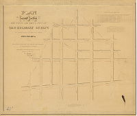
|
Plan of the Second Section of the survey of the Belmont Estate in the District of Belmont, made in pursuance of the provisions of Section 20th of the Act of Assembly of the Commonwealth of Pennsylvania, incorporating the District of Belmont. Approved the 14th Day of April 1853. Surveyed & returned by Joseph Fox, Surveyor, Charles H. Fox, assistant. 4th Mo, 30th 1854. Samuel L. Smedley, draftsman | Fox, Joseph; Fox, Charles H. | 1854 |
Mounted
33 x 40 in.
1 inch = 100 feet
|
West Philadelphia. Belmont Estate, 2nd Section. Bounded by Belmont Ave. to 49th St., Palmyra St. to Dauphin St.
Curb elevations, property lines, old roads
|
| 042-01 MTD |
|
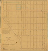
Plan of the Second division of the survey and regulation of the District of West Philadelphia. Made in conformity with an Act of the General Assembly of the Commonwealth of Pennsylvania passed the first day of May anno domini 1852, and agreeably to a resolution of the Board of Commissioners of the District of West Philadelphia passed the thirteenth day of October A.D. 1852. Surveyed and returned by Joseph Fox, Surveyor, 10th Mo. 12th 1853. Francis Lightfoot Assist. Surveyr. Drawn by Samuel L. Smedley. | Fox, Joseph; Lightfoot, Francis | 1853 |
Mounted
39 x 51 in.
|
West Philadelphia District, 2nd Division. Bounded by Beaver Run, Spruce St., Market St. and Schuylkill River
Curb elevations, lower section of Beaver Run, sewers projected to capture the flow of the upstream sections of Beaver Run
|