
Philadelphia Streets Department Surveys
2755 result(s). Showing results 1451 to 1500.
View page: 1 2 3 4 5 6 7 8 9 10 11 12 13 14 15 16 17 18 19 20 21 22 23 24 25 26 27 28 29 30 31 32 33 34 35 36 37 38 39 40 41 42 43 44 45 46 47 48 49 50 51 52 53 54 55 56 (Show all on one page)
| Identifer | Preview | Title | Surveyor | Date | Media / Size / Scale | Area / Map Features |
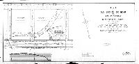
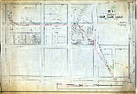
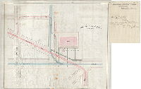
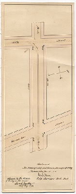
| JP-0665 |
|
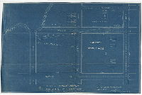
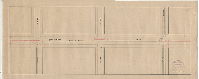
Plan of Thomas Avenue from 58th St. to County Line showing property to be taken by opening. Made for use of the Highway Com. April 8, 1893. Wm. H. Jones, Surveyor 12th Dist. [Shows Cobb's Creek and street that replaced Thomas Run] | Jones, William H. | 1893 |
Blueprint
11 x 18 in.
|
West Philadelphia, Thomas Avenue
Cobb's Creek, Baptist Orphanage, property owners, building footprints
|
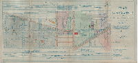
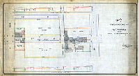
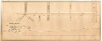
| JP-0671 |
|
Plan of 47th Street from Haverford St. to Fairmount Ave. For use of the Committee on Highways only. [Survey returned Nov. 1, 1897] | Johnson, Joseph | 1897 |
Blueprint
21 x 27 in.
|
West Philadelphia, 47th Street
Profile along street, property owners, house lots
|
| JP-0772 |
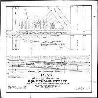
|
Plan showing sewer in Courtland Street from Broad to Fifteenth Street, Twenty-second Ward, Philadelphia. | Wagner, Joseph C. | 1896 |
Blueprint
25 x 25 in.
|
Logan. Courtland Street at Broad St.
Wingohocking Creek, profile of sewer, property owners
|
| JP-0813 |
|
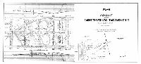
Plan of the Juniata Park. | Frazier, John W. | 1892 ca. |
Tracing
12 x 29 in.
|
Juniata Park and surrounding area, bounded roughly by Frankford Creek, L St., Cayuga St. and H. St.
Wingohocking and Frankford Creeks and tributaries
|
| JP-0862 |
|
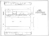
Plan showing mill property of Mary Ann Lord et al., at 47th and Market Sts., 27th Ward, ad location of Mill Creek Sewer in Meadow St. from Market to Chestnut St. | Jones, William H. | 1893 |
Blueprint
21 x 29 in.
|
West Philadelphia. Mary Lord Mill Property, bounded by Market, 46th, Chestnut and 48th Streets.
Footprint of mill, Mill Creek, other building footprints, sewer
|
| JP-1793 |
|
Plan for opening Brown Street from 50th to 51st St's. For use of the Road Jury only. [Ordinance July 7, 1908; lines confirmed July 17, 1858; grades confirmed March 8, 1884; survey returned June 5, 1909] | Johnson, Joseph | 1909 |
Blueprint
22 x 28 in.
|
West Philadelphia. Brown Street, 50th to 51st Sts.
Property lines, building footprints
|
| JP-1824 |
|
Plan for opening Brown Street from Forty-ninth St. to Fiftieth St. For use of the Road Jury only. [Ordinance July 7, 1908; lines confirmed July 17, 1858; grades confirmed Jan. 6, 1896; survey returned Nov. 4, 1909] | Johnson, Joseph | 1909 |
Blueprint
35 x 33 in.
|
West Philadelphia. Brown Street, 49th to 50th Sts.
Property lines, building footprints
|
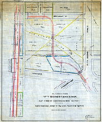
| JP-2063 |
|
Plan for the use of the jury in the matter of the revision of a portion of Plan No. 58 made necessary by the construction of the Pennsylvania Ave. Subway. Fifteenth Ward, Philadelphia | Bloch, Frits | 1897 |
Mounted
41 x 58 in.
1 inch = 15 feet
|
Pennsylvania Avenue Subway. Bounded by Broad St. to 12th St., Hamilton St. to Callowhill St.
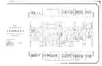
Color coded with building footprints, railroad tracks, profiles of buildings with illustrations of facades. These buildings were affected by the lowering of the Reading Railroad below grade into the subway that still runs under Pennsylvania Avenue.
|
| JP-2063-A tracing |
|
Plan for the use of the jury in the matter of the revision of a portion of Plan No. 58 made necessary by the construction of the Pennsylvania Ave. Subway. Fifteenth Ward, Philadelphia | Bloch, Frits | 1897 |
Tracing
34 x 57 in.
1 inch = 30 feet
|
Pennsylvania Avenue Subway. Callowhill Street from Broad St. to east of 13th St.
Color coded with building footprints, railroad tracks, profiles of buildings with illustrations of facades. These buildings were affected by the lowering of the Reading Railroad below grade into the subway that still runs under Pennsylvania Avenue.
|
| JP-2063-B tracing |
|
Plan for the use of the jury in the matter of the revision of a portion of Plan No. 58 made necessary by the construction of the Pennsylvania Ave. Subway. Fourteenth Ward, Philadelphia | Bloch, Frits | 1897 |
Tracing
36 x 56 in.
1 inch = 30 feet
|
Pennsylvania Avenue Subway. 13th St. from Carlton St. to Nectarine St.
Color coded with building footprints, railroad tracks, profiles of buildings with illustrations of facades. These buildings were affected by the lowering of the Reading Railroad below grade into the subway that still runs under Pennsylvania Avenue.
|
| JP-2063-E tracing |
|
Plan for the use of the jury in the matter of the revision of a portion of Plan No. 63 made necessary by the construction of the Pennsylvania Ave. Subway. Fifteenth Ward, Philadelphia | Bloch, Frits | 1896 |
Tracing
39 x 52 in.
1 inch = 40 feet
|
Pennsylvania Avenue Subway. Bounded by 15th to 18th Sts., Hamilton to Callowhill Sts.
Color coded with building footprints, railroad tracks, profiles of buildings with illustrations of facades. These buildings were affected by the lowering of the Reading Railroad below grade into the subway that still runs under Pennsylvania Avenue.
|
| JP-2063-F |
|
Plan for the use of the Jury in the matter of the revision of a portion of Plan No. 67 made necessary by the construction of the Pennsylvania Ave. Subway. Fifteenth Ward, Philadelphia | Bloch, Frits | 1895 |
Blueprint
34 x 76 in.
1 inch = 30 feet
|
Pennsylvania Avenue Subway. 22nd St. to 25th St. and adjacent area
Color coded with building footprints, railroad tracks, profiles of buildings with illustrations of facades. These buildings were affected by the lowering of the Reading Railroad below grade into the subway that still runs under Pennsylvania Avenue.
|
| JP-2212 |
|
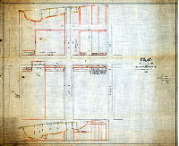
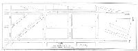
Plan [and profile] of Old Second St. Road from Sheridan Street to 199' east of Sixth Street, Thirty-ninth Ward, Philadelphia. Made for the Board of View in the matter of the vacation thereof by decree of Court of Quarter Sessions No. 2, April 18, 1914 [Survey returned Jan. 18, 1916] | Puff, Charles F., Jr. | 1916 |
Blueprint
21 x 45 in.
1 inch = 40 feet
|
Old Second Street Road
Property lines, areas and owners, deed information, building footprints
|
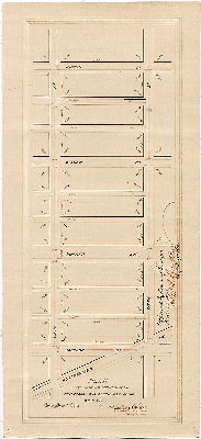
| JP-2289-b |
|
Plan of Snyder Avenue from Twenty-third to Thirty-second St., Forty-eight Ward, Philadelphia. Prepared for use of the Board of View in the matter of the opening thereof under ordinance approved April 26, 1915. | Reeder, W. C. | 1916 |
Paper
21 x 45 in.
1 inch = 80 feet
|
South Philadelphia. Bounded by McKean St., 26th St., Jackson St. and 32nd St.
Topography, building footprints, property lines and ownership, profiles of elevations
|
| JP-2289-c |
|
Plan of Snyder Avenue from Twenty-third to Thirty-second St., Forty-eight Ward, Philadelphia. Prepared for use of the Board of View in the matter of the opening thereof under ordinance approved April 26, 1915. | Reeder, W. C. | 1916 |
Paper
20 x 45 in.
1 inch = 80 feet
|
South Philadelphia. Bounded by McKean St., 23rd St., Jackson St., 26th St. and Point Breeze Ave.
Topography, building footprints, property lines and owners, profile of elevations
|
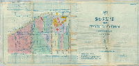
| JP-2332 |
|
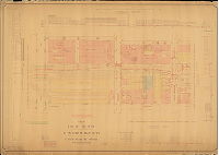
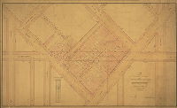
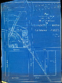
[No title. Color coded plan showing properties and related jury plans, road docket files, affidavits, deeds, ordinances, resolutions, and other documents related to the acquisition of properties for The Benjamin Franklin Parkway, Logan Square to Fairmount Park at the Art Museum] | Not named | 1944 ca. |
Blueprint, positive, hand colored
25 x 53 in.
|
Benjamin Franklin Parkway
Index map with list of authorizing ordinances keyed to each section of map
|
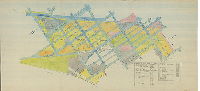
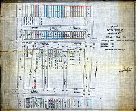
| JP-2335 |
|
Plan for use of the Board of View in the matter of the opening of the unopened portion of The Parkway between City Hall and Fairmount Park, portion between Broad St. & west of 16th St., Philadelphia [Ordinances March 28, 1903; June 27, 1904; June 8, 1909] | Reeder, W. C. | 1916 |
Paper
35 x 52 in.
1 inch = 20 feet
|
Benjamin Franklin Parkway
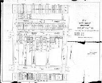
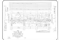
Property lines, size and material of buildings, dates of deeds. Table: "Title brief of properties purchased since Nov. 9, '06"
|
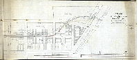
| JP-2422 |
|
Plan [and profile] of Jackson Street from Twenty-fourth Ave. to Twenty-eighth St., Forty-eighth Ward, Philadelphia. Prepared for the use of the Board of View in the matter of opening thereof, under ordinance approved Dec. 23rd 1915. [Survey returned Aug. 7, 1917] | Nobré, John M. | 1917 |
Blueprint
20 x 44 in.
|
South Philadelphia. Snyder Ave. to Wolf St., 24th to 28th Sts.
Topography, profile of Jackson St., building footprints and property owners and acreage including property of Jarden Brick Co., William H. Wilson Park
|
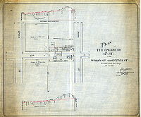
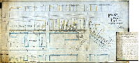
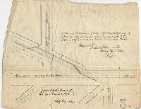
| JP-Francisville |
|
Plan made for Committee of Councils of properties affected by the opening of Seventeenth Street from Francis St. to Ridge Ave., Fifteenth Ward, Philadelphia. | Not named | 1902 |
Mounted
32 x 52 in.
1 inch = 20 feet
|
Francisville, vicinity of 17th and Francis Sts.
Plan to open 17th Street through a section of the Francisville neighborhood. Shows property owners and valuations.
|
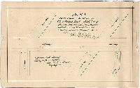
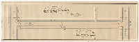
| JP-SD7th 01 |
|
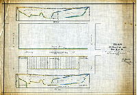
Plan of the change of grade of Markoe St. from Haverford St. to Fairmount Ave. For the use of the Road Jury only. Dec. 26, 1893. | Johnson, Joseph | 1893 |
Tracing
20 x 28 in.
|
West Philadelphia. Markoe St
Profiles of street showing amounts filled by various parties.
|
| JP-SD7th 02 |
|
Plan for the opening of 47th Street between Seneca St. & Westminster Ave. For the use of the "Road Jury" only. Feb. 18, 1897. | Johnson, Joseph | 1897 |
Tracing
|
West Philadelphia. 47th St.
Profile on unfilled streets, property owners, building footprints
|
| JP-SD7th 03 |
|
Plan for the opening of 47th Street from Brown St. to Seneca St. For use of the Road Jury only. Scale 1 inch -- 40 ft. Dec. 20, 1895 | Johnson, Joseph | 1895 |
Tracing
|
West Philadelphia. 47th St.
Profile on unfilled streets, property owners, building footprints
|
| JP-SD7th 04 |
|
Plan of extension of Fifty Second St. Main Sewer from a point near 52nd Street and Lancaster Avenue to a point in Monticello Street, 523' 9-7/8" west of 52nd St. For use of Road Jury only. Jan. 15, 1895 | Johnson, Joseph | 1895 |
Tracing
|
West Philadelphia, 52nd Street Sewer
Profile along line of sewer, property owners, George's Run
|
| JP-SD7th 05 |
|
Plan for the opening of Brown St. from 50th to 51st Sts. Authorized by ordinance of Councils, approved March 20, 1909. Lines confirmed July 17, 1858. Grades confirmed March 8, 1884. For use of Road Jury only. June 5, 1909 | Johnson, Joseph | 1909 |
Tracing
|
West Philadelphia, Brown St.
Property owners
|
| JP-SD7th 06 |
|
[Handwritten title on reverse: "Jury Plan. Mill Creek Sewer from 48th to 51-1/2 St." No date] | Not named | 1890 ca. |
Tracing
|
West Philadelphia, Mill Creek Sewer
Line of sewer, property owners
|
| JP-SD7th 07 |
|
Plan showing construction of Mill Creek Sewer across property of William Wright, Dec'd. For use of Road Jury only. Scale 1 inch = 40 ft. June 8, 1894 | Johnson, Joseph | 1894 |
Tracing
|
West Philadelphia, Mill Creek Sewer, 52nd St.and Westminster Ave.
Creek, profile along line of sewer, property lines
|
| JP-SD7th 08 |
|
Plan of Mill Creek Sewer from 55-1/2 to 55th St. For use of the Road Jury. Dec. 1, 1893 [See also JP-0607] | Johnson, Joseph | 1893 |
Tracing
|
West Philadelphia, Mill Creek Sewer
Creek, mill race in Hunter's Mills, Providence Worsted Mill, building footprints, property owners, profile along line of sewer
|
| JP-SD7th 09 |
|
Plan for assessment of damages along the line of Mill Creek Sewer from Westminster Avenue to Fifty-Third Street. Oct. 27, 1892 | Johnson, Joseph | 1892 |
Blueprint, folded
|
West Philadelphia, Mill Creek Sewer
Creek, line of sewer, property owners
|
| JP-SD7th 10 |
|
Plan for the assessment of damages along the line of Mill Creek Sewer west of 52nd St. July 21, 1893 [See also JP-0634] | Johnson, Joseph | 1893 |
Tracing
|
West Philadelphia, Mill Creek Sewer
Creek, line of sewer, property owners, profile along Suplee St.
|
| JP-SD7th 11 |
|
Plan for the opening of Peach St. from Lancaster Ave. to Master St. For use of Road Jury only. May 25, 1894 [With attached list of damage awards] | Johnson, Joseph | 1894 |
Tracing
|
West Philadelphia, Peach St.
Profile of along street, property owners, building footprints
|
| JP-SD7th 12 |
|
Plan of Mill Creek Sewer from 47th St. to Haverford St. For use of the Road Jury. Nov. 8, 1893 [See also JP-0603] | Johnson, Joseph | 1893 |
Tracing
|
West Philadelphia, Mill Creek Sewer
Profile of sewer, creek and tributary, house lots and property owners, building footprints
|
| JP-SD7th 13 |
|
Plan of Mill Creek Sewer from Lansdowne Ave. to Pennsylvania R.R. For the use of the Jury. Oct. 3, 1893 | Johnson, Joseph | 1893 |
Tracing
|
West Philadelphia, Mill Creek Sewer
Creek, sewer, property owners and house lots, profile along sewer
|
| JP-SD7th 14 |
|
Plan of Brown St. from 48th to Markoe St. For use of the Road Jury only. April 20, 1894 | Johnson, Joseph | 1894 |
Tracing
|
West Philadelphia, Brown St.
Profile along street, property owners, house lots
|
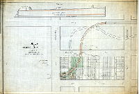
| JP-SD7th 15 |
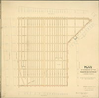
|
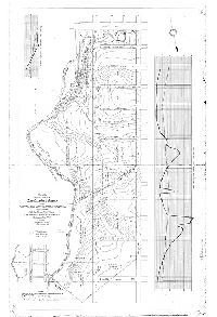
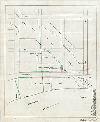
Plan of the unopened portion of Cobbs Creek Park and Parkway from Market St. to the south line of Cedar Ave. extended. Forty-sixth Ward. Made for the Law Department in the matter of the condemnation thereof. [Ordinance May 4, 1911] | Gillingham, J. Harvey | 1912 |
Tracing
44 x 30 in.
|
West Philadelphia. Bounded by Cobbs Creek, 63rd St., Market St. and Cedar Ave.
Topography, property owners and acreage
|
| RC-001-f |
|
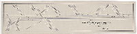
Plan of Schuylkill River Pass. R.W. Co.'s track on 22nd St. from Walnut to Filbert [With attached letter] | Not named | 1883 |
Tracing
9 x 42 in.
|
Schuylkill River Passenger Railway Co.
Street Railway
|
| RC-001-g |
|
Plan showing proposed track of the Schuylkill River Passenger Railway Co. and the Philadelphia City Passenger Railway Co. on Twenty-second St. [Confirmed April 21, 1884] | Shedaker, David Hudson | 1884 |
Tracing
10 x 43 in.
|
Schuylkill River Passenger Railway Co.
Street Railway
|
| RC-001-x |
|
[Handwritten title on reverse: "Schuylkill River & Grays Ferry Pass'r. Railway on 22nd St. between Chestnut & Walnut Sts." Approved by Board of Surveyors June 18, 1883] | Not named | 1883 |
Mounted
12 x 29 in.
1 inch = 30 feet
|
Schuylkill River and Grays Ferry Passenger Railway, 22nd Street
Street Railway
|
| RC-001-y |
|
Plan of tracks on Grays Ferry Ave. between South and Catharine Sts., 30th Ward | Daly, Thomas | 1896 |
Tracing
11 x 42 in.
|
Street railway, tracks on Grays Ferry Ave.
Street Railway
|
| RC-001-z |
|
[No title. Right of way of the Schuylkill River East Side Railroad] | Not named | 1900 ca. |
Tracing
22 x 28 in.
|
South Philadelphia. Bounded by Reed St., 35th St. Tasker St. and Schuylkill River
Railroad, property lines and ownership, Philadelphia Rubber Works, Loomis-Manning Filter Manufacturing Co.
|
| RC-002-b |
|
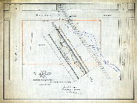
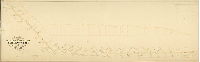
Plan shewing the extension of the Philadelphia and Darby Rail Road to Fairmount Park via Lancaster & Belmont Aves., 24th Ward, Philadelphia [Approved by Board of Surveyors Sept. 15, 1873] | Hancock, George W. | 1873 |
Mounted
37 x 117 in.
|
West Philadelphia. Tracks on Belmont Ave. from Elm Ave. to Lancaster Ave, and on Lancaster from Belmont to Market St.
Street Railway
|
| RC-002-c |
|
Plan of the Fairmount Park extension of the tracks of the Philadelphia and Darby Passenger Railway Co. along 32nd Street from Market Street to Chestnut Street | Jones, William H. | 1873 |
Mounted
19 x 54 in.
|
Philadelphia and Darby Passenger Railway Co. Bounded by Market to Chestnut Sts., 33rd St. to Schuylkill River
Street Railway
|
| RC-002-d |
|
Plan of siding of the Philadelphia & Darby Passenger Railway at 32nd Street & Lancaster Avenue, 24th Ward [Approved by Board of Surveyors March 6, 1876] | Hancock, George W. | 1876 |
Paper, Tracing
12 x 15 in.
|
Philadelphia and Darby Passenger Railway
Street Railway
|
| RC-002-e |
|
Plan of proposed location of a Centennial siding from the Phila. & Darby Pass. R.W. tracks on the east side of Belmont Ave. from Jefferson Avenue to Columbia Avenue [Approved by Board of Surveyors March 20, 1876] | Hancock, George W. | 1876 |
Mounted
13 x 21 in.
|
Philadelphia and Darby Passenger Railway
Street Railway
|
| RC-002-f |
|
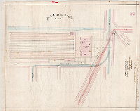
Plan of West Philada. Pass'r Sta. [Approved April 3, 1876] | Not named | 1876 |
Tracing
26 x 33 in.
1 inch = 40 feet
|
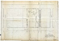
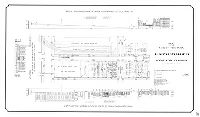
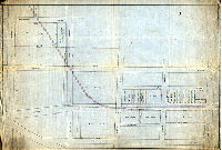
West Philadelphia Passenger Railway Co. 32nd and Market Sts.
Pennsylvania Railroad depot. Shows alignment of street railway tracks around this new station. Building footprint shows uses of various rooms.
|
| RC-002-g |
|
West Philada. Pass'r. Tracks [Attached letter of transmittal from James K. McClure, president, Pennsylvania Railroad Company, to Samuel L. Smedley, Chief Engineer and Surveyor of Philadelphia, Sept. 13, 1876] | Not named | 1876 |
Tracing
22 x 27 in.
1 inch = 40 feet
|
West Philadelphia Passenger Railway Co. 32nd and Market Sts.
Pennsylvania Railroad depot. Shows alignment of street railway tracks around this new station.
|
| RC-003-c |
|
Plan of proposed extension of the Frankford & Southwark Passenger Railway Company through Powell Street in the Fifth Ward of the City of Philada. [Approved by Board of Surveyors June 17, 1861] | Shedaker, David Hudson | 1861 |
Mounted
8 x 27 in.
|
Frankford and Southwark Passenger Railway Co.
Street Railway
|
| RC-003-d |
|
Plan of extension of the Frankford and Southwark Passenger Railway [Approved by Board of Surveyors Sept. 15, 1873] | Davis, James P. | 1873 |
Mounted
34 x 33 in.
|
Street railway tracks on Lehigh Ave., Kensington Ave., Front St., Berks St., and 6th St. back to Lehigh Ave.
Street Railway
|
| RC-003-e |
|
Plan of proposed extension of the Frankford & Southwark Railway Company [Approved by Board of Surveyors June 21, 1875] | Close, Charles S. | 1875 |
Mounted
12 x 10 in.
|
Frankford and Southwark Passenger Railway Co.
Street Railway
|
| RC-003-h |
|
Section of the Frankford & Southwark Passenger Railway, Philadelphia, Dec. 1st, 1882 [Approved by Board of Surveyors Dec. 4, 1882] | Mercer, Joseph | 1882 |
Mounted
26 x 10 in.
|
Frankford and Southwark Passenger Railway Co.
Street Railway
|
| RC-003-J |
|
Section of proposed track belonging to the Frankford & Southwark Passenger Railway Co. [Approved by Board of Surveyors Feb. 17, 1890] | Mercer, Joseph | 1890 |
Mounted
17 x 42 in.
|
Frankford and Southwark Passenger Railway Co., Front St. between York St. and Lehigh Ave.
Street Railway
|