
Philadelphia Streets Department Surveys
2755 result(s). Showing results 151 to 200.
View page: 1 2 3 4 5 6 7 8 9 10 11 12 13 14 15 16 17 18 19 20 21 22 23 24 25 26 27 28 29 30 31 32 33 34 35 36 37 38 39 40 41 42 43 44 45 46 47 48 49 50 51 52 53 54 55 56 (Show all on one page)
| Identifer | Preview | Title | Surveyor | Date | Media / Size / Scale | Area / Map Features |
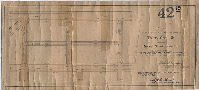
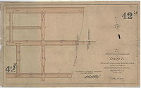
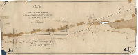
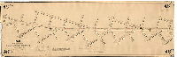
| 042-01 MTD levels |
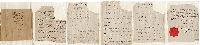
|
Table showing the changes to be made in the curb levels, streets &c in the Plan of the Second Division of the Survey and Regulation of the District of West Philadelphia … Filed April 20, 1854. Decree of Court [of Quarter Sessions.] | 1854 |
Paper
|
West Philadelphia District, 2nd Division. Bounded by Beaver Run, Spruce St., Market St. and Schuylkill River
Attachment
|
|
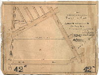
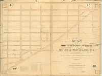
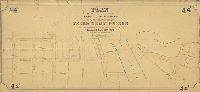
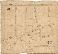
| 042-02 MTD |
|
Plan of revised grade regulation of Market Street and vicinity in the 24th Ward | Miller, James, and Smedley, Samuel S. | 1859 |
Mounted
38 x 21 in.
|
West Philadelphia, Market St.. Bounded by Cranmond (now 33rd) St. and Schuylkill River, York (now Sansom) St. and Arch St.
Curb elevations, sewers, wharves, bridge at Market St.
|
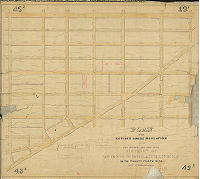
| 042-03 MTD |
|
Plan of the revised grade regulations of the Second Section of the District of West Philadelphia in the Twenty-fourth Ward, City of Philadelphia.. Made in accordance with a resolution of Councils passed Nov. 1861 by James Miller. [Confirmed Board of Surveyors Feb. 17, 1862] | Miller, James | 1861 |
Mounted
30 x 33 in.
|
West Philadelphia District, 2nd Section. Bounded by Beaver Run, Spruce St., Market St. and Schuylkill River
Curb elevations, lower section of Beaver Run, and sewers that are projected to capture the flow of the upstream sections of Beaver Run
|
| 042-04 MTD |
|
Plan of Lehman Street between Market and Chestnut in the Twenty-fourth Ward Philadelphia [Approved by Board of Surveyors March 3, 1856] | Not named | 1856 |
Mounted
17 x 17 in.
|
West Philadelphia. Bounded by Market, Chestnut, Mansion and Bridgewater Sts.
Cub elevations
|
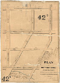
| 042-05 MTD |
|
Plan of Thirty-first Street as reduced in width between Chestnut and Spruce Streets in accordance with a resolution of Councils approved March 24th A.D. 1864. [Confirmed Sept. 5, 1864] | Miller, James | 1864 |
Mounted
20 x 14 in.
|
West Philadelphia. Bounded by 30th to 31st Sts., Chestnut to Spruce Sts.
Curb elevations, sewers, Beaver Run
|
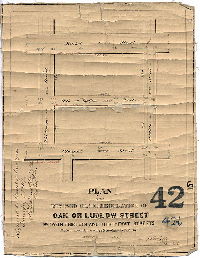
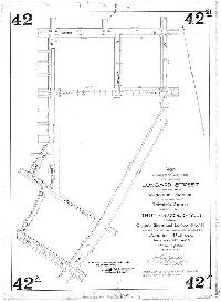
| 042-06 MTD |
|
Plan of the revised grade regulation of Oak or Ludlow Street between Thirtieth and Thirty-first Streets. Made in accordance with a resolution of Councils approved 1866. Ja. Miller Dec. 1866. [Approved by Board of Surveyors, Jan. 7, 1867] | Miller, James | 1866 |
Mounted
13 x 10 in.
|
West Philadelphia. Bounded by Mart, Chestnut, Thirtieth and Thirty-first Sts.
Curb elevations, sewers
|
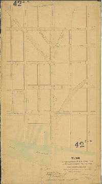
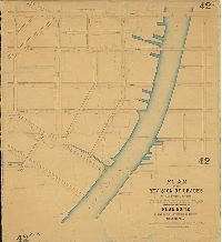
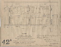
| 042-07 MTD |
|
Plan of the revision of grades in that portion of the Twenty-seventh Ward embraced in the limits of Plan No. 42 on file in the Department of Surveys, Philadelphia, made in accordance with an ordinance of Councils approved January 11th, 1878. Returned March 9th, 1878, William H. Jones, Surveyor & Regulator, 12th Dist. | Jones, William H. | 1878 |
Mounted
39 x 35 in.
|
West Philadelphia. Bounded roughly by South St., 33rd St., Market St. and 24th St.
Beaver Run from Schuylkill River to 33rd and Locust Sts., curb elevations, wharves
|
| 042-08 MTD |
|
Plan of St. James and Chancellor Streets from 32nd St. to 33rd St. 27th Ward. Phila. [Ordinance March 5, 1878; survey returned March 9, 1878; confirmed: July 1, 1878] | Jones, William H. | 1878 |
Mounted
11 x 12 in.
|
West Philadelphia
Curb elevations
|
| 042-11 MTD |
|
Plan to reduce the width of Thirty-first Street between Market St. and Chestnut St. 27th Ward Philad'a., to make said street 60 ft. wide by taking 20 ft. from the easterly side thereof. [Ordinance Sept. 24, 1889; survey returned Dec. 19, 1889; confirmed Feb. 3, 1890] | Jones, William H. | 1889 |
Paper
12 x 15 in.
|
West Philadelphia
Curb elevations, building footprints, street railway
|
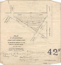
| 042-12 MTD |
|
Plan of Irving Street from Thirty-second Street to Marston Street in the Twenty-seventh Ward Philadelphia. [Ordinance Oct. 21, 1889; survey returned Dec. 2, 1889; confirmed Feb. 3. 890] | Jones, William H. | 1889 |
Paper
12 x 12 in.
|
West Philadelphia
Curb elevations, building footprints
|
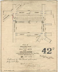
| 042-13 MTD |
|
Plan of Chancellor Street between 33rd St. and 34th St. in the 27th Ward Philada. [Ordinance July 2, 1889; survey returned July 15, 1889; confirmed July 21, 1890] | Jones, William H. | 1889 |
Paper
14 x 11 in.
1 inch = 100 feet
|
West Philadelphia
Curb elevations, building footprints
|
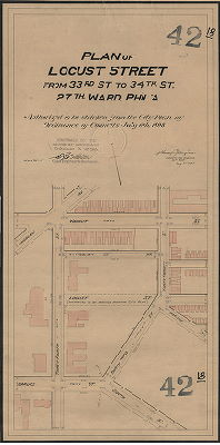
| 042-18 MTD |
|
Plan of Locust Street from 33rd St. and 34th St. 27th Ward Phila. [Ordinance July 6, 1898; survey returned Aug. 31, 1898; confirmed Oct. 3, 1898] | Gillingham, J. Harvey | 1898 |
Mounted
26 x 15 in.
1 inch = 50 feet
|
West Philadelphia
Building footprints
|
| 042-19 MTD |
|
Plan of the revision of lines and grade of Thirty-first St. between Market St. and Chestnut St. 27th Ward Phila. and to vacate a portion thereof. [Ordinance March 9, 1903; survey returned April 10, 1903; confirmed June 1, 1903] | Gillingham, J. Harvey | 1903 |
Mounted
10 x 21 in.
|
West Philadelphia
Curb elevations
|
| 042-20 MTD |
|
Plan to strike from the City Plan Thirty-first Street from Walnut St to Lombard St. 27th Ward Phila. [Ordinance March 21, 1903; survey returned May 4, 1903; confirmed June 1, 1903] | Gillingham, J. Harvey | 1903 |
Mounted
15 x 20 in.
|
West Philadelphia
Curb elevations
|
| 042-21 MTD |
|
Plan striking from the City Plan and vacating Lombard Street from the east line of Midland Avenue to the west line of Thirtieth Street and that portion of Thirty-second Street between Chestnut Street and Lombard Street which is east of the easternmost main track of the Junction Railroad. Twenty-seventh Ward, Philadelphia. [Ordinance March 28, 1904; survey returned May 4, 1904; confirmed Nov. 17, 1904] | Gillingham, J. Harvey | 1904 |
Mounted
28 x 20 in.
1 inch = 100 feet
|
West Philadelphia
Curb elevations
|
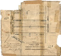
| 042-22 MTD |
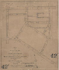
|
Plan of the revision of grades upon portions of City Plan Nos. 42, 43 & 269 bounded by Walnut St., 32nd St., South St. Spruce St. & 34th St. Twenty-seventh Ward, Phila. [Ordinance Feb. 15, 1909; confirmed May 3, 1909] | Gillingham, J. Harvey | 1909 |
Mounted
20 x 17 in.
1 inch = 100 feet
|
West Philadelphia
Curb elevations
|
| 042-24 MTD |
|
Plan for the revision of curb lines & grades of Chestnut St. from Thirtieth St. to center line of Schuylkill River. Twenty-seventh Ward. [Ordinance April 6, 1911; confirmed Oct. 9, 1911] | Gillingham. J. Harvey | 1911 |
Mounted
15 x 24 in.
|
West Philadelphia
Curb elevations
|
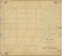
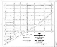
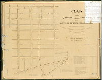
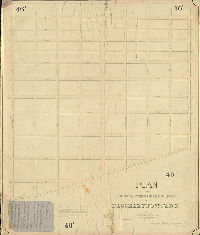
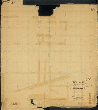
| 043-01 MTD |
|
Plan of the First Division of the survey and regulation of the District of West Philadelphia made in conformity with an Act of the General Assembly of the Commonwealth of Pennsylvania, passed the first day of May, anno Domini 1852, and agreeably to a resolution of the Board of Commissioners of the District of West Philadelphia, passed the thirteenth day of October A.D. 1852. Approved by the Board of Commissioners of the District of West Philadelphia May 9th, 1853. Surveyed and returned by Joseph Fox, Francis. Lightfoot, Surveyor, 5th mo 9th 1853. | Fox, Joseph; Lightfoot, Francis | 1853 |
Mounted
37 x 51 in.
1 inch = 100 feet
|
West Philadelphia District, First Section. Bounded by Market St. to Woodland Ave., Till [40th] St. to Mansion [32nd] St.
Oddfellows Hall at 37th and Market Sts., benchmark buildings, sewers, course of Beaver Run (lightly penciled), proposed streets in yellow; William J. Canby, draftsman
|
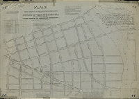
| 043-02 MTD |
|
Plan of the revised grade regulation of the First Section of the survey of the District of West Philadelphia in the Twenty-fourth Ward, City of Philadelphia [Resolution Nov. 18, 1861;approved by Board of Surveyors Feb. 17, 1862; confirmed by Act of Assembly April 17, 1862] | Miller, James | 1862 |
Mounted
35 x 41 in.
|
West Philadelphia District, 1st Section. Bounded by Spruce St., Woodland Ave., 40th St., Market St., and 33rd St.
Curb elevations, sewers
|
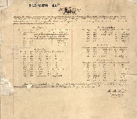
| 043-02 MTD levels |
|
[No title. Table showing changes in curb levels as depicted in Plan 043-02_MTD] | Fox, Joseph | 1853 |
Paper
16 x 18 in.
|
West Philadelphia District, 1st Section. Bounded by Spruce St., Woodland Ave., 40th St., Market St., and 33rd St.
Attachment
|
| 043-02 MTD tracing |
|
Plan of the revised grade regulation of the First Section of the survey of the District of West Philadelphia in the Twenty-fourth Ward, City of Philadelphia [Resolution Nov. 18, 1861; approved by Board of Surveyors Feb. 17, 1862; confirmed by Act of Assembly April 17, 1862] | Miller, James | 1862 |
Tracing
36 x 43 in.
|
West Philadelphia District, 1st Section. Bounded by Spruce St., Woodland Ave., 40th St., Market St., and 33rd St.
Curb elevations
|
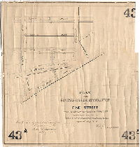
| 043-03 MTD |
|
Plan of the revised grade regulation of Pine Street from Thirty-ninth Street to Fortieth Street. [Resolution May 4, 1872; confirmed Oct. 7, 1872] | Jones, William H. | 1872 |
Mounted
18 x 18 in.
|
West Philadelphia. Pine St., 39th to 40th Sts.
Curb elevations, sewer
|
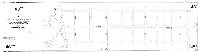
| 044-01 MTD |
|
Plan of the Third Division of the survey and regulation of the District of West Philadelphia. [Tracing made in 1888, of original plan from 1852. Original plan not found.] | Fox, Joseph | 1854 |
Tracing
41 x 60 in.
|
West Philadelphia, 3rd Division. Bounded by Bridge (Spring Garden) St. and Market St., 38th St. and Schuylkill River
Curb elevations, sewers, building footprints, wharves. Tracing has no color, although it includes a "NOTE" in the upper left referring to red and blue lines that would have been in the original plan.
|
| 044-02 MTD |
|
Plan of the revised grade regulation of part of the Third District of the survey of West Philadelphia. [Act of Assembly May 13, 1856; approved by Board of Surveyors Nov. 3, 1856; confirmed by Court Aril 25, 1857] | Not named | 1856 |
Mounted
39 x 47 in.
|
West Philadelphia, 3rd District. Bounded north by Bridge (Spring Garden) St., south by Market St. and Lancaster Ave., east by 35th St. and west by Schuylkill River
Curb elevations, sewers, stream, Pennsylvania Railroad
|
| 044-03 FLAT |
|
Plan for the alteration in the line of Thirty-second Street in the Twenty-fourth Ward. [Resolution, Sept. 22, 1859; approved by Board of Surveyors Jan. 15, 1860; confirmed by Court June 11, 1860] | Smedley, Samuel L. | 1859 |
Paper
16 x 39 in.
|
West Philadelphia. 32nd St. from Powelton Ave. to Arch St.
Curb elevations
|
| 044-08 MTD |
|
Plan of the revision of the lines and grades to the approaches of Fairmount Bridge and contiguous streets, affected thereby. [Ordinance?] Approved April 19th, 1875. Surveyed and returned by George H. Hancock, Surv. & Reg. 11th Dist. 7-1-75. | Hancock, George W. | 1875 |
Mounted
20 x 43 in.
|
West Philadelphia. Bounded roughly by Spring Garden St. from 25th St. to 34th St., and on west side of Schuylkill River bounded by the river, 34th St., Haverford Ave. and Hamilton St.
Curb elevations, Fairmount Reservoir, bridge, Schuylkill River
|
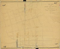
| 045-01 HP |
|
Plan of the Fourth Division of the survey and regulation of the District of West Philadelphia made in conformity with an Act of the General Assembly of the Commonwealth of Pennsylvania, passed the first day of May, anno Domini 1852, and agreeably to a resolution of the Board of Commissioners of the District of West Philadelphia, passed the thirteenth day of October, A.D. 1852. Surveyed & returned by Joseph Fox, Surveyor, Francis Lightfoot, Asst. Survyr., 8th mo 16th 1854 | Fox, Joseph; Lightfoot, Francis | 1854 |
Mounted
37 x 48 in.
1 inch = 100 feet
|
West Philadelphia, 4th Division. Bounded by Market St. to Woodland Ave., 44th to 39th Sts.
Buildings in projected street lines, sewers, penciled Mill Creek tributaries; Samuel L. Smedley, draftsman
|
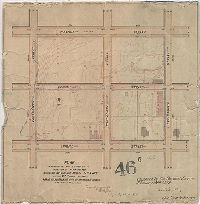
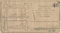
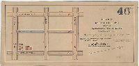
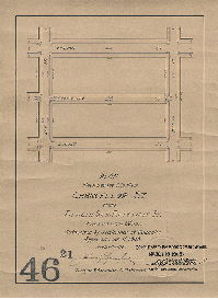
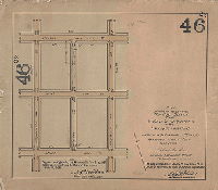
| 046-01 MTD |
|
Plan of the survey of the First Section of Blockley Township. [Act of Assembly April 3, 1851; survey returned Nov. 1853; confirmed by Court June 27, 1854] | Miller, James | 1853 |
Mounted
54 x 45 in.
|
West Philadelphia, Blockley Township, 1st Section. Bounded by Baltimore Ave. and Market St., 44th and 52nd Sts.
Old roads
|
| 046-02 MTD |
|
Plan of the changed line of Baltimore Avenue between Forty-fourth and Fifty-fourth Streets. As directed by resolution of Councils Approved March 24th, 1864. Approved by Board of Surveyors September 19, 1864. James Miller, Surveyor, 12th District. In 90.15, p. 39. | Miller, James | 1864 |
Mounted
17 x 52 in.
1 inch = 125 feet
|
West Philadelphia
Curb elevations
|
| 046-03 MTD |
|
Plan of revision of grades of ground between Forty-second and Forty-sixth Streets and Baltimore Avenue and Spruce Street in the Twenty-seventh Ward Philadelphia. Made in accordance with resolution of Councils approved March 11, 1871. William H. Jones, Surveyor, 12th District. [Confirmed April 17, [1871?] | Jones, William H. | 1871 |
Mounted
24 x 26 in.
|
West Philadelphia
Curb elevations
|
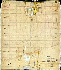
| 046-04 MTD |
|
Plan of the First Section of a survey of Blockley. Made in conformity with an Act of Assembly of the Commonwealth of Pennsylvania approved April 3rd, 1851, with the curb heights fixed thereon. By order of the Department of Surveys of the City of Philadelphia.... With the revision of lines as authorized by resolution of Councils approved May 25, 1872 [Confirmed Dec. 1, 1873] | Jones, William H. | 1873 |
Mounted
48 x 45 in.
|
West Philadelphia, Blockley Township, 1st Section. Bounded by Baltimore Ave. and Market St., 44th and 52nd Sts.
Curb elevations, sewers, streams , mill races, mill ponds, property ownership and acreage shown in pencil. This is a copy of 046-1, with revisions and streams added.
|
| 046-05 MTD |
|
Plan of the revision of the lines and grades of Fifty-second Street from Market Street to Baltimore Avenue in the Twenty-seventh Ward of the City of Philadelphia, to make the street eighty feet in width, in accordance with an ordinance of Councils approved February 25, 1884. William H. Jones, surveyor. [Confirmed August 4, 1884] | Jones, William H. | 1884 |
Mounted
18 x 71 in.
|
West Philadelphia
Curb elevations
|
| 046-06 MTD |
|
Plan of revision of the grades on a portion of Plan No. 46 bounded by Walnut, Spruce, 44th and 46th St. in the 27th Ward Philada. Made in accordance with an ordinance of Councils approved April 3, 1888. Returned June 4, 1888, William H. Jones, Surveyor & Regulator 12th District. Confirmed by the Board of Surveyors February 18th, 1889. | Jones, William H. | 1888 |
Mounted
16 x 16 in.
|
West Philadelphia. Bounded by Walnut St., 44th St., Spruce St. and 46th St.
Topography, building footprints, Mill Creek tributary
|
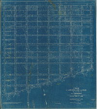
| 046-07 MTD |
|
Plan of the revision of lines and grades on Plan No. 46 with topography. Authorized by ordinance of Councils approved April 7th 1893. [survey returned June 15, 1895; confirmed 1895 and 1896] | Jones, William H. | 1895 |
Mounted
53 x 47 in.
|
West Philadelphia. Bounded by Market St. to Baltimore Ave., 44th to 52nd Sts.
Topography, streams including Mill Creek tributary along 46th Street, building footprints
|
| 046-07 MTD blueprint |
|
Plan of the revision of lines and grades on Plan No. 46 with topography. [Ordinance April 7th 1893; survey returned June 15, 1895; confirmed 1895 and 1896] | Jones, William H. | 1895 |
Blueprint
53 x 47 in.
|
West Philadelphia. Bounded by Market St. to Baltimore Ave., 44th to 52nd Sts.
Topography, streams including Mill Creek tributary along 46th Street, building footprints
|
| 046-08 MTD |
|
Plan of Lex Street from Walnut St. to Locust St. 27th Ward Phila. [Ordinance June 9, 1896; survey returned June 17, 1898; confirmed Oct. 19, 1896. | Gillingham, J. Harvey | 1896 |
Mounted
12 x 9 in.
1 inch = 100 feet
|
West Philadelphia
Curb elevations
|
| 046-09 MTD |
|
Plan of Naudain Street from Fiftieth Street to Fifty-second Street, Twenty-seventh Ward, Philadelphia. [Ordinance July 9, 1892; surveyed July 15, 1892; confirmed Nov. 1, 1897] | Gillingham, J. Harvey | 1892 |
Mounted
11 x 21 in.
1 inch = 100 feet
|
West Philadelphia
Curb elevations
|
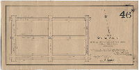
| 046-10 MTD |
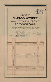
|
Plan of Naudain Street from 47th St. to 48th St. 27th Ward Phila. [Ordinance April 2, 1898; survey returned April 1898; confirmed June 20, 1898] | Gillingham, J. Harvey | 1898 |
Mounted
19 x 12 in.
1 inch = 100 feet
|
West Philadelphia
Curb elevations
|
| 046-11 MTD |
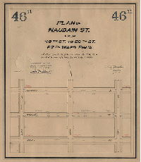
|
Plan of Naudain St. from 48th St. to 50th St. 27th Ward, Phila. [Ordinance July 20, 1898; survey returned Aug. 25, 1898; confirmed Sept. 19, 1898] | Gillingham, J. Harvey | 1898 |
Mounted
19 x 17 in.
1 inch = 100 feet
|
West Philadelphia
Curb elevations
|
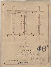
| 046-12 MTD |
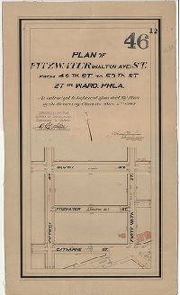
|
Plan of Fitzwater (Walton Ave.) St. from 49th St. to 50th St. 27th Ward, Phila. [Ordinance June 2, 1898; survey returned June 1898; confirmed Oct. 3, 1898] | Gillingham, J. Harvey | 1898 |
Mounted
20 x 12 in.
1 inch = 100 feet
|
West Philadelphia
Curb elevations
|
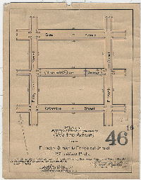
| 046-13 MTD |
|
Plan of the revision of lines and grades on that portion of City Plan No. 46 bounded by Market St., Fifty-first St., Chestnut St. and Fifty-second St. 27th Ward Phila. [Ordinance March 12, 1901; survey returned March 21, 1901; confirmed May 13, 1901] | Gillingham, J. Harvey | 1901 |
Mounted
9 x 17 in.
1 inch = 100 feet
|
West Philadelphia
Curb elevations
|
| 046-14 MTD |
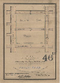
|
Plan showing the lot of ground bounded by 51st, 52nd, Pine and Lombard Sts. as authorized to be placed on the City Plan as a public park [Black Oak Park] [Ordinance April 8, 1902; survey returned April 28, 1902; confirmed Aug. 4, 1902] | Gillingham, J. Harvey | 1902 |
Mounted
14 x 10 in.
1 inch = 100 feet
|
West Philadelphia
Curb elevations
|
| 046-15 MTD |
|
Plan of Melville St. from Walnut to Spruce St. [Ordinance Dec. 24, 1902; survey returned Jan. 15, 1903; confirmed April 6, 1903] | Gillingham, J. Harvey | 1903 |
Mounted
10 x 20 in.
1 inch = 100 feet
|
West Philadelphia
Curb elevations
|
| 046-16 MTD |
|
Plan of Fitzwater St. formerly (Walton Ave.) St. from Fiftieth Street to Fifty-first Street, 27th Ward, Phila. [Ordinance March 31, 1903; survey returned May 4, 1903; confirmed June 1, 1903 | Gillingham, J. Harvey | 1903 |
Mounted
14 x 11 in.
1 inch = 100 feet
|
West Philadelphia
Curb elevations
|
| 046-17 MTD |
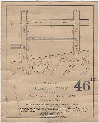
|
Plan of Webster Street from Fifty-first St. to Fifty-second St. 27th Ward Phila. | Gillingham, J. Harvey | 1903 |
Mounted
13 x 11 in.
1 inch = 100 feet
|
West Philadelphia
Curb elevations
|
| 046-18 MTD |
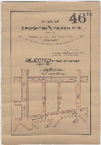
|
Plan of Creighton and Paxon Sts. From Baltimore Ave. to Catharine St. [Rejected by Board of Surveyors July 6, 1903] | Gillingham, J. Harvey | 1903 |
Mounted
15 x 11 in.
1 inch = 100 feet
|
West Philadelphia
Curb elevations
|
| 046-19 MTD |
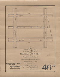
|
Plan for placing on the City Plan Irving Street from Fiftieth Street to Fifty-first Street in the Twenty-Seventh Ward. | Gillingham, J. Harvey | 1905 |
Mounted
14 x 11 in.
1 inch = 100 feet
|
West Philadelphia
Curb elevations
|
| 046-20 MTD |
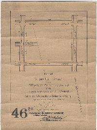
|
Plan of Chancellor Street from Fifty-first Street eastward in the Twenty-seventh Ward. [Ordinanc Oct. 3, 1906; confirmed March 16, 1908] | Gillingham, J. Harvey | 1908 |
Mounted
14 x 10 in.
1 inch = 100 feet
|
West Philadelphia
Curb elevations
|
| 046-21 MTD |
|
Plan for placing on the City Plan Chancellor St. from Fiftieth St. to Fifty-first St. Forty-sixth Ward. | Gillingham, J. Harvey | 1908 |
Mounted
13 x 10 in.
1 inch = 100 feet
|
West Philadelphia
Curb elevations
|
| 046-22 MTD |
|
Plan for placing on the City Plan Marko Street from Walnut St. to Spruce St. in the Twenty-seventh Ward. | Gillingham, J. Harvey | 1906 |
Mounted
15 x 17 in.
1 inch = 100 feet
|
West Philadelphia
Curb elevations
|