
Philadelphia Streets Department Surveys
2755 result(s). Showing results 2051 to 2100.
View page: 1 2 3 4 5 6 7 8 9 10 11 12 13 14 15 16 17 18 19 20 21 22 23 24 25 26 27 28 29 30 31 32 33 34 35 36 37 38 39 40 41 42 43 44 45 46 47 48 49 50 51 52 53 54 55 56 (Show all on one page)
| Identifer | Preview | Title | Surveyor | Date | Media / Size / Scale | Area / Map Features |
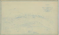
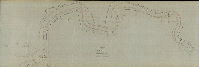
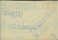
| RC-J Delaware 125-126 |

|
[Composite chart made by attaching two discreet charts, as follows: 1. Coast Chart No. 125. Delaware River, Cross Ledge to Penn's Neck. Published May 1890. 2. Coast Chart No. 126. Delaware River, Penn's Neck to Philadelphia. Published March 1891] | USCGS | 1891 |
Paper
32 x 54 in.
1:80000
|
Delaware River. On east (New Jersey) side, from Maurice River Cove to Fisher's Point; on west side, from Mahon's River (Delaware) to Bridesburg (Philadelphia)
Soundings, marshland, lighthouses and other navigational aids, river banks or dikes, channels, streams, inlets, points, communities adjacent to shoreline with buildings, roads, wharves and other features
|
| RC-J Delaware1940 1 |
|
Delaware River Harbor Lines. Marcus Hook, Pa. to Philadelphia, Pa. Resurveyed 1939. In six sheets. U.S. Engineer Office. May 25, 1940. 1. Marcus Hook to Ridley Creek. | USACE | 1940 |
Blueprint
27 x 40 in.
1 inch = 800 feet
|
Delaware River harbor lines, Marcus Hook to Ridley Creek
Wharves, riverfront industry and landmarks, diagrams of surveying stations, islands, other features
|
| RC-J Delaware1940 2 |
|
Delaware River Harbor Lines. Marcus Hook, Pa. to Philadelphia, Pa. Resurveyed 1939. In six sheets. U.S. Engineer Office. May 25, 1940. 2. Ridley Creek to Hog Island. | USACE | 1940 |
Blueprint
27 x 40 in.
1 inch = 800 feet
|
Delaware River harbor lines, Ridley Creek to Hog Island
Wharves, riverfront industry and landmarks, diagrams of surveying stations, islands, other features
|
| RC-J Delaware1940 3 |
|
Delaware River Harbor Lines. Marcus Hook, Pa. to Philadelphia, Pa. Resurveyed 1939. In six sheets. U.S. Engineer Office. May 25, 1940. 3. Hog Island to Howell Cove. | USACE | 1940 |
Blueprint
27 x 40 in.
1 Inch = 800 feet
|
Delaware River harbor lines, Hog Island to Howell Cove
Wharves, riverfront industry and landmarks, diagrams of surveying stations, islands, other features
|
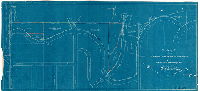
| RC-J Delaware1940 3 attachment |

|
[Memo and diagram describing Triangulation Station Hiarc, "on the lawn of the Atlantic Refining Co. office building above Hog Island," attached to plan RC-J-Delaware1940_3] | Not named | 1946 |
Paper
|
Delaware River
Riverfront triangulation
|
| RC-J Delaware1940 4 |

|
Delaware River Harbor Lines. Marcus Hook, Pa. to Philadelphia, Pa. Resurveyed 1939. In six sheets. U.S. Engineer Office. May 25, 1940. 4. Howell Cove to Delaware River Bridge. | USACE | 1940 |
Blueprint
27 x 40 in.
1 Inch = 800 feet
|
Delaware River harbor lines, Howell Cove to Delaware River (now Benjamin Franklin) Bridge
Wharves, riverfront industry and landmarks, diagrams of surveying stations, islands, other features
|
| RC-J Delaware1940 5 |

|
Delaware River Harbor Lines. Marcus Hook, Pa. to Philadelphia, Pa. Resurveyed 1939. In six sheets. U.S. Engineer Office. May 25, 1940. 5. Delaware River Bridge to Frankford Creek. | USACE | 1940 |
Blueprint
27 x 40 in.
1 Inch = 800 feet
|
Delaware River harbor lines, Delaware River (now Benjamin Franklin) Bridge to Frankford Creek
Wharves, riverfront industry and landmarks, diagrams of surveying stations, islands, other features
|
| RC-J Delaware1940 6 |
|
Delaware River Harbor Lines. Marcus Hook, Pa. to Philadelphia, Pa. Resurveyed 1939. In six sheets. U.S. Engineer Office. May 25, 1940. 6. Frankford Creek to Poquessing Creek. | USACE | 1940 |
Blueprint
27 x 40 in.
1 Inch = 800 feet
|
Delaware River harbor lines, Frankford Creek to Poquessing Creek
Wharves, riverfront industry and landmarks, diagrams of surveying stations, islands, other features
|
| RC-J Delaware1940 6 attachment |

|
[Public notice of the revision of a section of the pierhead and bulkhead line described in Plan RC-J_Delaware1940_6] | Not named | 1956 |
Paper
|
Delaware River
Attachment: Diagram of small section of Delaware River and written description
|
| RC-J Delaware1940 7 |

|
Delaware River Harbor Lines. Marcus Hook, Pa. to Philadelphia, Pa. Resurveyed 1939. In six sheets. U.S. Engineer Office. May 25, 1940. Bristol | USACE | 1940 |
Blueprint
27 x 40 in.
1 Inch = 800 feet
|
Delaware River harbor lines, Bristol
Wharves, riverfront industry and landmarks, diagrams of surveying stations, islands, other features
|
| RC-J Delaware1940 8 |

|
Delaware River Harbor Lines. Marcus Hook, Pa. to Philadelphia, Pa. Resurveyed 1939. In six sheets. U.S. Engineer Office. May 25, 1940. Bordentown to Trenton. | USACE | 1940 |
Blueprint
27 x 40 in.
1 Inch = 800 feet
|
Delaware River harbor lines, Bordentown to Trenton
Wharves, riverfront industry and landmarks, diagrams of surveying stations, islands, other features
|
| RC-J Delaware1940 9 |
|
Delaware River Harbor Lines. Marcus Hook, Pa. to Philadelphia, Pa. Resurveyed 1939. In six sheets. U.S. Engineer Office. May 25, 1940. Trenton and Morrisville | USACE | 1940 |
Blueprint
27 x 40 in.
1 Inch = 800 feet
|
Delaware River harbor lines, Trenton and Morrisville
Wharves, riverfront industry and landmarks, diagrams of surveying stations, islands, other features
|
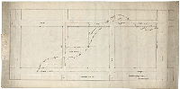
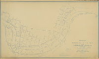
| RC-K-1 |

|
Map of property in Philadelphia and Delaware County owned by John Black and Edgar A. Black. Made by G. P. N. Sadler. | Sadler, G. P. N. | 1874 |
Tracing
43 x 107 in.
1 inch = 200 feet
|
Southwest Philadelphia and Delaware County.
Property lines, building footprints, creeks, bridges, river bank
|
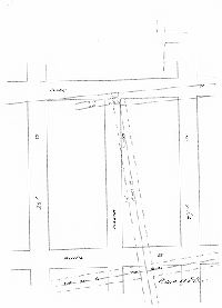
| RC-K-6 |
|
[No title. Property line survey at Darby Road (Woodland Avenue) and Mill Creek, for Lewis and Mary Jones. Also shows "Jacob Mayland's property"] | Roberts, Edward D. | 1848 |
Mounted
12 x 15 in.
|
West Philadelphia
Property owners, chart of courses and distances, Mill Creek
|
| RC-K-7 |

|
East Falls Village. In Park. | Not named | 1870 ca. |
Tracing
16 x 84 in.
|
Schuylkill River, properties on east bank, in East Falls along the east side of Ridge Ave. from Falls Ferry Rd. to Weightman St.
Property lines and owners, building footprints, Powers & Weightman, Reading Railroad. Shows property taken for Fairmount Park.
|
| RC-K-8 |

|
Draught of a tract or piece of land situated in the Township of Blockley in the County of Philadelphia (called the Wood-lands) the property of Thomas Flemming, containing eight-four acres, three quarters, and twenty-five perches of arable land; and four acres, half an acre, and fifteen perches of marsh to low-water mark. Surveyed the 25th of October, 1830, by Jno. Thomson. | Thomson, John | 1830 |
Mounted
14 x 16 in.
1 inch = 15 perches
|
West Philadelphia. Woodlands, now Woodlands Cemetery, property in the vicinity of present-day Woodland Ave. and 38th St.
Text added using Photoshop. This was a "preservation scan" - the plan is nearly torn in half and severely curled, and the scans did not capture all the text, which was only readable by folding back the folded-over sections visible in the scan.
|
| RC-KK-3 |

|
Plan of Weccacoe Square in the Third Ward [Survey returned Feb. 15, 1889; confirmed April 1, 1889] | Daly, Thomas | 1889 |
Mounted
14 x 18 in.
|
South Philadelphia. Weccacoe Square, located between Catherine, Queen, Cobb and Weccacoe Sts.
Dimensions of square
|
| RC-KK-v |

|
Copy of plan of property belonging to the Pleasant Hill Land Association, Twenty-third Ward, Philadelphia. | Webster, George S. | 1889 |
Paper
10 x 15 in.
|
Northeast Philadelphia. Pleasant Hill Land Association, near Delaware Ave. and Linden Ave.
Property lines
|
| RC-KK-w |

|
Platting for Ontario Park. 20th Ward. Dept. of Public Works, Bureau of Surveys, Philadelphia | Not named | 1894 |
Blueprint
21 x 28 in.
|
Ontario Park, bounded by Thompson, 13th, Stiles and Ontario Sts.
Paths, trees, benches, flower beds, flag pole, detail of a section of coping
|
| RC-KK-x |

|
Plan of Wharton Square in the Twenty-sixth Ward. [Ordinance April 11, 1890] | Daly, Thomas | 1890 |
Mounted
13 x 13 in.
|
South Philadelphia. Wharton Square, bounded by 23rd, Reed, 24th and Wharton Sts.
Dimensions of square
|
| RC-KK-z |
|
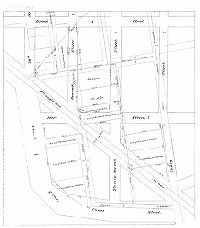
[No title. Land transfers between Stocker and McAnany, occasioned by the laying of the grid over property lines formerly defined by Mollebore Creek. Broad to 17th, Curtin to Packer. Note on reverse: "Broad and Ritner. Dye, Eng.] | Dye, John H. | 1895 |
Tracing
17 x 34 in.
|
South Philadelphia. Bounded by Broad St. to 17th St., Curtin St. to Packer Ave.
Property lines
|
| RC-K-w |

|
Triangulation of the City of Philadelphia. 1894. Neville B. Craig, Topographer | Craig, Neville B. | 1894 |
Blueprint
34 x 28 in.
|
Philadelphia
Triangulation stations
|
| RC-K-x1 |

|
[No title. Property survey, vicinity of 28th and Parrish Streets, for Wickersham. Shows Henry St. and Mill St., both vacated.] | Roberts, Edward D. | 1871 |
Tracing
17 x 25 in.
|
28th and Parrish Sts.
Property lines
|
| RC-K-x2 |
|
[No title. Property survey, vicinity of 27th and Parrish Streets, for Snyder. Shows Henry and Centre Streets vacated.] | Roberts, Edward D. | 1871 |
Tracing
20 x 15 in.
|
27th and Parrish Sts.
Property lines
|
| RC-K-x3 |
|
[No title. Property survey, vicinity of 27th and Parrish, for Brinton. In original, vacated streets - Manor St., Bush Hill St., Canal Alley and Acorn Alley - drawn in red ink] | Roberts, Edward D. | 1871 |
Tracing
26 x 24 in.
|
27th and Parrish Sts.
Property lines
|
| RC-K-y1 |

|
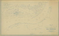
House of Correction, 41st Ward, Holmesburg, Philadelphia, PA. Survey of Property. Set A, Sheet 1. Department of City Architecture, Philadelphia, PA. John P. B. Sinkler, Director. CWA 51-0199. | Not named | 1936 ca. |
Blueprint
42 x 50 in.
1 inch = 100 feet
|
Northeast Philadelphia. Holmesburg
Building footprints identified by use, Pennypack Creek and tributary, dock and slip at Delaware River
|
| RC-K-y2 |

|
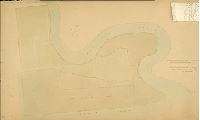
[No title. Area around mouth of Pennypack Creek and along the Delaware River, probably made as plan of City Property] | Not named | 1915 ca. |
Tracing
37 x 75 in.
|
Northeast Philadelphia. Property at mouth of Pennypack Creek, between Delaware River and the creek
River bank, Pennypack Creek and tributaries, building footprints including House of Correction, Home for the Indigent, Torresdale Filters, Pennypack Sewage Treatment Works; indications of "solid ground" and ground that was "filled in," "swamp not filled"
|
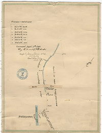
| RC-K-z |
|
[No title. Survey of House of Correction property] | Davis, James P. | 1870 |
Mounted
32 x 53 in.
|
Northeast Philadelphia. Property at mouth of Pennypack Creek, between Delaware River and the creek
Pennypack Creek and marshlands
|
| RC-L-z |

|
Plan showing proposed annexation of properties to Fairmount Park. Approved 1895. | Thayer, Russell | 1895 |
Paper
16 x 23 in.
|
West Philadelphia. Properties on west side of Schuylkill River, between Falls Bridge and City Ave. Bridge
William Simpson, Algernon Isaac Roberts, and Joseph Rubicam properties in West Fairmount Park; Philadelphia and Reading Railroad
|
| RC-M-1 |
|
Harbor lines for the Delaware and Schuylkill Rivers at the Harbor of Philadelphia, Pa. recommended by the Board of Engineer Officers constituted by S. O. 21, War Department, Office of the Chief Engineers, June 30, 1904. Compiled from surveys made in October and November 1901 under the direction of Lieut. Col. C. W. Raymond, Corps of Engineers, U.S. Army. Delaware River - Gloucester to Schuylkill River. | USACE | 1904 |
Blueprint
35 x 57 in.
|
Delaware River, Gloucester to Schuylkill River.
Pierhead and bulkhead line, building footprints, river bank, marshland, wharves
|
| RC-M-2 |
|
Harbor lines for the Delaware and Schuylkill Rivers at the Harbor of Philadelphia, Pa. recommended by the Board of Engineer Officers constituted by S. O. 21, War Department, Office of the Chief Engineers, June 30, 1904. Compiled from surveys made in 1904 under the direction of Major J. C. Sanford, Corps of Engineers, U.S. Army. Delaware River - Kaighn Point to Gloucester. | USACE | 1904 |
Blueprint
35 x 44 in.
|
Delaware River, Kaighn Point to Gloucester.
Pierhead and bulkhead line, building footprints, river bank, marshland, railroads, wharves
|
| RC-M-3 |
|
Harbor lines for the Delaware and Schuylkill Rivers at the Harbor of Philadelphia, Pa. recommended by the Board of Engineer Officers constituted by S. O. 21, War Department, Office of the Chief Engineers, June 30, 1904. Compiled from surveys made in August and September 1901 under the direction of Lieut. Col. C. W. Raymond, Corps of Engineers, U.S. Army. Delaware River - Palmyra to Five Mile Point. | USACE | 1904 |
Blueprint
35 x 58 in.
|
Delaware River, Palmyra to Five Mile Point.
Pierhead and bulkhead line, building footprints, river bank, marshland, railroads, wharves
|
| RC-M-4 |
|
Harbor lines for the Delaware and Schuylkill Rivers at the Harbor of Philadelphia, Pa. recommended by the Board of Engineer Officers constituted by S. O. 21, War Department, Office of the Chief Engineers, June 30, 1904. Compiled from surveys made in August and September 1901 under the direction of Lieut. Col. C. W. Raymond, Corps of Engineers, U.S. Army. Delaware River - Poquessing Creek to Palmyra. | USACE | 1904 |
Blueprint
35 x 55 in.
|
Delaware River, Poquessing Creek to Palmyra.
Pierhead and bulkhead line, building footprints, river bank, marshland, railroads, wharves
|
| RC-M-z |
|
Plan showing route of National Underground Electric Company [conduit], First section. | Shedaker, David Hudson | 1881 |
Tracing
25 x 138 in.
|
Philadelphia. Conduits along Market and Chestnut Sts. from Delaware Ave. to City Hall.
Underground conduits for electric service
|
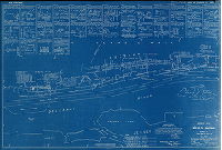
| RC-N |
|
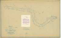
Sheet No. I. Schuylkill River, from Gibson's Wharf to the Mouth. Surveyed by order of Colonel J. N. Macomb, Corps of Engineers, U.S.A under the direction of Captain Wm. Ludlow, Corps of Engineers, Bvt. Lt. Col U.S.A., by John Mechan and Edwin Ludlow M.E., Asst. Engrs., November & December 1879 | USACE | 1879 |
Tracing
44 x 102 in.
1 inch = 200 feet
|
Schuylkill River, Gibson's Wharf to mouth
Attachment with written description.
|
| RC-N N-1 attachment |

|
Description of pier and bulkhead lines proposed for the Schuylkill R[iver] as shown in the accompanying charts dated May 1882 .. Sheet No. 1 .. and Sheet No. 2 | USACE | 1882 |
Paper
|
Schuylkill River
Pierhead and bulkhead lines
|
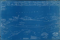
| RC-N-1 |

|
Sheet No. II. Schuylkill River, from Callowhill Street Bridge to Gibson's Wharf. Surveyed by order of Colonel J. N. Macomb, Corps of Engrs., U.S.A under the direction of Captain Wm. Ludlow, Corps of Engrs., Bvt. Lt. Col U.S.A., by John Mechan, Edwin Ludlow & John R. Suydan Jr., Asst. Engrs. | Ludlow, William, and others | 1880 |
Tracing
44 x 87 in.
1 inch = 200 feet
|
Schuylkill River, Callowhill Street Bridge to Gibson's Wharf
Wharves, river bank, marshland, industrial buildings, railroad, rocks. Attachment with written description.
|
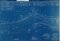
| RC-N-2 |
|
[No title. Schuylkill River from the confluence with the Delaware River to South Street, 1881] | Not named | 1881 |
Tracing
44 x 146 in.
|
Schuylkill River
River bank, soundings, channel width
|
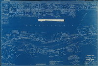
| RC-N-2a |

|
[No title. Schuylkill River from mouth to South Street. This is probably a preliminary tracing of Plan 301-1 HP] | Not named | 1883 ca. |
Tracing
43 x 283 in.
|
Schuylkill River from South St. to Delaware River
River bank, soundings, bridges.
|
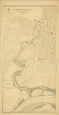
| RC-N-3 |
|
Philadelphia Water Front. Schuylkill River. United States Coast and Geodetic Survey … Published … November 1900. No. 381. | USCGS | 1900 |
Paper
28 x 56 in.
1 inch = 800 feet
|
Schuylkill River from Fairmount Dam to Delaware River
Soundings, building footprints, bridges, tributary streams, marshland, river bank, wharves
|
| RC-N-4 |
|
Harbor lines for the Delaware and Schuylkill Rivers at the Harbor of Philadelphia, Pa. recommended by the Board of Engineer Officers constituted by S. O. 21, War Department, Office of the Chief Engineers, June 30, 1904. Compiled from surveys made in December 1897 and January 1898 under the direction of Major C. W. Raymond, Corps of Engineers, U. S. Army, and in September 1902 and in 1904 by the City of Philadelphia | USACE | 1904 |
Blueprint, Mounted
35 x 54 in.
|
Schuylkill River, Walnut Street Bridge to Tasker Street
Harbor lines, wharves, bridges, river banks, marshland, and other riverfront features
|
| RC-N-5 |

|
Harbor lines for the Delaware and Schuylkill Rivers at the Harbor of Philadelphia, Pa. recommended by the Board of Engineer Officers constituted by S. O. 21, War Department, Office of the Chief Engineers, June 30, 1904. Compiled from surveys made in December 1897 and January 1898 under the direction of Major C. W. Raymond, Corps of Engineers, U. S. Army, and in September 1902 by the City of Philadelphia | USACE | 1904 |
Blueprint, Mounted
35 x 51 in.
|
Schuylkill River, Tasker St. to Point Breeze
Harbor lines, wharves, bridges, river banks, marshland, and other riverfront features
|
| RC-N-6 |
|
Harbor lines for the Delaware and Schuylkill Rivers at the Harbor of Philadelphia, Pa. recommended by the Board of Engineer Officers constituted by S. O. 21, War Department, Office of the Chief Engineers, June 30, 1904. Compiled from surveys made in December 1897 and January 1898 under the direction of Major C. W. Raymond, Corps of Engineers, U. S. Army, and in 1902, 1903 and 1904 by the City of Philadelphia | USACE | 1904 |
Blueprint, Mounted
35 x 59 in.
|
Schuylkill River, Point Breeze to the Delaware River
Harbor lines, wharves, bridges, river banks, marshland, and other riverfront features
|
| RC-N-7 |
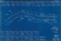
|
Schuylkill River. Harbor lines. Market St. to Spring Garden St. U. S. Engineer Office, Phila., PA. June 4, 1928. | Shuman, L. D. | 1928 |
Blueprint
27 x 41 in.
1 inch = 200 feet
|
Schuylkill River, Market St. to Spring Garden St.
Harbor lines, wharves, bridges, river banks, marshland, and other riverfront features; sketches of surveying reference stations and charts of coordinates and courses
|
| RC-O-v |

|
New boundary of [Fairmount] park. [Originally numbered P-4-54] | Not named | 1918 |
Blueprint
13 x 22 in.
|
Bounded by Wayne Ave., South Mt. Pleasant St., Green St. and Sedgwick St.
Boundary change, probably in relation to annexation of the property for Fairmount Park now known as Carpenter's Woods
|
| RC-O-w |
|
Plan of properties between Fairmount Park between Fairmount Park Line and the street system from Hermit St. to Roxborough Ave. Twenty-first Ward. [Originally numbered P-4-35] | Sundstrom, C. A. | 1915 |
Blueprint
18 x 38 in.
|
Roxborough
Park boundary and adjacent property owners
|
| RC-O-x |
|
Plan showing the location of pools of water, creeks, ditches & marsh lands, in area bounded by Broad St. on the east, the Schuylkill River on the west, Reed St. on the north and Government and Schuylkill Aves. on the South | Nobré, John M. | 1916 |
Tracing
28 x 38 in.
|
South Philadelphia. Bounded by Reed St. to Government and Schuylkill Aves., Broad St. to Schuylkill River
Marshland, streams, creeks, ditches, canals, ponds
|
| RC-O-y |
|
Plan of farms and lots included in Fairmount Park. East Park, south of Connecting R.R. Bridge above Girard Avenue. Compiled by J. W. Bowley 1937. | Bowley, J. W. | 1937 |
Blueprint
31 x 67 in.
1 inch = 100 feet
|
Bounded roughly by Pennsylvania Ave. to west side of Schuylkill River, 24th St. to Girard Ave.
Shows original property owners and dates of deeds of purchase.
|
| RC-O-z |
|
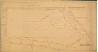
[No title. Plan for passenger railroad station at Elm Avenue and Belmont Avenue. "Between Penna. R.R. and Elm Avenue from Belmont Av. to 52nd Street content is 106 A."] | Smedley, Samuel L. | 1872 |
Mounted
27 x 52 in.
1 inch = 100 feet
|
West Philadelphia. Properties and acreage bounded by Elm Ave. (now Parkside Ave.), Belmont Ave., Pennsylvania Railroad, and 52nd St.
Passenger station on Belmont Ave., possibly in anticipation of the 1876 Centennial Exhibition
|
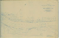
| RC-Q DelRiver1 |

|
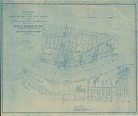
Chart of the Delaware River in front of the City of Philadelphia from Bridesburg to Fort Mifflin [With triangulation stations and ranges added in 1882] | USCGS | 1882 |
Mounted
28 x 82 in.
1:9600, or 1 inch = 800 feet
|
Delaware River
Location of triangulation points used to create accurate surveys; and many other topographic features
|