
Philadelphia Streets Department Surveys
2755 result(s). Showing results 2251 to 2300.
View page: 1 2 3 4 5 6 7 8 9 10 11 12 13 14 15 16 17 18 19 20 21 22 23 24 25 26 27 28 29 30 31 32 33 34 35 36 37 38 39 40 41 42 43 44 45 46 47 48 49 50 51 52 53 54 55 56 (Show all on one page)
| Identifer | Preview | Title | Surveyor | Date | Media / Size / Scale | Area / Map Features |
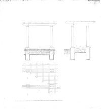
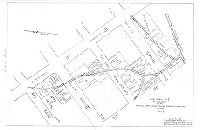
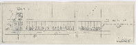
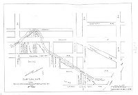
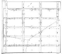
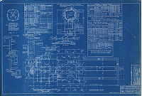
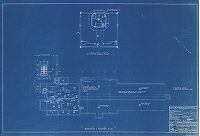
| SD5th-044H |
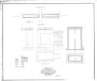
|
Details of the improvement of Twenty-seventh St. between Allegheny Ave. and Willard St. as a garden street, Thirty-eighth Ward, Philadelphia. | Not named | 1917 ca. |
Tracing
36 x 44 in.
1/4 inch = 1 foot
|
North Philadelphia
Architectural details
|
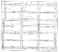
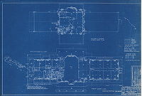
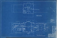
| SD5th-044I |
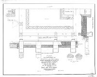
|
Plan for improvement of Twenty-seventh St. between Allegheny Ave. and Willard St. as a garden street, showing floor, parapet walls and step on one quarter section of the north and south terrace, Thirty-eighth Ward, Philadelphia. | Not named | 1917 ca. |
Tracing
30 x 36 in.
1 inch = 1 foot
|
North Philadelphia
Architectural details
|
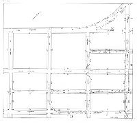
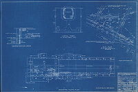
| SD5th-044J |
|
Details of the improvement of Twenty-seventh St. between Allegheny Ave. and Willard St. as a garden street, Thirty-eighth Ward, Philadelphia. | Wingate, W. F. | 1919 |
Tracing
30 x 40 in.
Not noted
|
North Philadelphia
Architectural details, and summary of materials
|
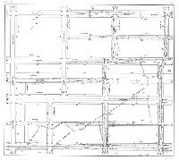
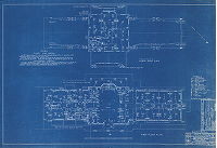
| SD5th-044K |
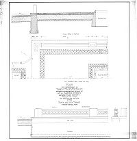
|
Plan for improvement of Twenty-seventh St. between Allegheny Ave. and Willard St. as a garden street, showing floor, parapet walls and step on one quarter section of the north and south terrace, Thirty-eighth Ward, Philadelphia. | Not named | 1917 ca. |
Tracing
36 x 36 in.
1 inch = 1 foot
|
North Philadelphia
Architectural details
|
| SD5th-044L |
|
[No title. Design for pergola, in conjunction with improvement of Twenty-seventh St. as a garden block.] | 1917 ca. |
Tracing
36 x 34 in.
Not noted
|
North Philadelphia
Architectural details
|
|
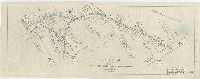
| SD7th FC6-43 |
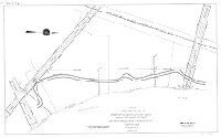
|
Sketch made for the use of the Department Wharves, Docks and Ferries showing the location of stakes from Pennypacker Avenue to Penrose Avenue. Fortieth Ward, Philadelphia | Engle, Amos B. | 1928 |
Tracing
29 x 46 in.
1 inch = 100 feet
|
Southwest Philadelphia
Location of river bank or dike
|
| SD7th FC6-44 |
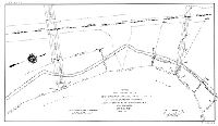
|
Sketch made for the use of the Department Wharves, Docks and Ferries showing the location of stakes from Sixth-seventh St. to Pennypacker Avenue. Fortieth Ward, Philadelphia | Engle, Amos B. | 1928 |
Tracing
21 x 36 in.
1 inch = 100 feet
|
Southwest Philadelphia
Location of river bank or dike
|
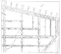
| SD7th FC6-50 |
|
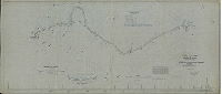
[No title. Schuylkill River soundings at its confluence with the Delaware River] | Not named | 1880 ca. |
Tracing
24 x 36 in.
|
Delaware and Schuylkill Rivers, confluence
Soundings, grain elevator wharf, League Island
|
| SD7th FC6-53 |
|
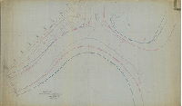
[Schuylkill River] From Penrose Ferry Bridge to Delaware River. Approved October 1883. G. Weitzel, Lieut. Cdr. Of Engrs U.S.A., Chairman, Advis. Commission; Thos. L. Casey, 1st Lt. Engr U.S.A., Secty. To Adv. Commission. Samuel L. Smedley, Chief Engr. & Sur. | Weitzel, G. | 1883 |
Tracing
43 x 74 in.
|
Schuylkill River, from Penrose Ferry to Delaware River.
Soundings, Schuylkill River; League Island
|
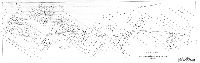
| SD7th FC6-59 |
|
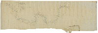
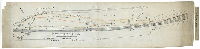
Chart of the Schuylkill River from its mouth to the Chestnut St. Bridge. Surveyed during the summer and fall of 1871, under the direction of Lt. Col. J. D. Kurtz, Corps of Eng's. U.S.A by W. C. Cranmer C.E. | Cranmer, William C. | 1873 |
Tracing
32 x 91 in.
|
Schuylkill River, from the Delaware River to Chestnut St.
Soundings, buildings of refineries and gas works, super phosphate works, chemical works, iron works, etc. Inset shows South Street Bridge. "Note: For dredging in progress see sketches accompanying Monthly Report, with letter of Dec'r. 5th, 1873."
|
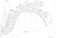
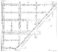
| SD7th FC6-72 |
|
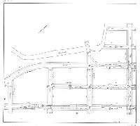
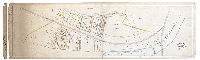
Plan and profile of Mingo Creek (Drainage Canal) from 74th St. (Mingo Pumping Station) to Island Ave. 40th Ward, Philadelphia. Made for the Bureau of Highways | Thorpe, Frederick T., Jr. | 1934 |
Tracing
36 x 84 in.
1 inch = 100 feet
|
Southwest Philadelphia. Mingo Creek, from 74th and Penrose to 80th and Laycock.
Mingo Creek, with profile of the channel and elevations
|
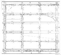
| SD7th FC6-73 |
|
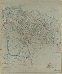
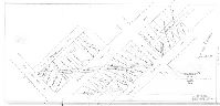
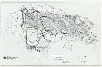
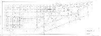
Plan showing water courses, drainage streets, ditches, etc. in the 40th Ward Philadelphia, made for the Bureau of Highways. [Plan from files of 7th Survey District] AT CP, found 10 detailed subplans numbered 1 through 10. Pencil on tracing paper. Scanned on plotter. [This had been listed in the index of Red Can O, but was found at 7th Survey District] | Shegog, George T. | 1937 |
Tracing
44 x 37 in.
1 inch = 500 feet
|
Southwest Philadelphia
Topography, contours, concrete drainage canal, ditches and water courses, dikes, pumping stations, sluice gates, sewers, railroad, Philadelphia Rapid Transit street railway line, swamp land, property lines and owners, existing buildings, fill areas. Ten detailed subplans are also included in this collection.
|
| SD7th FC6-73-01 |
|
Plan showing water courses, drainage streets, ditches, etc. in the 40th Ward Philadelphia, made for the Bureau of Highways. Subplan 1. [Creeks from Este Ave. to Dicks Ave., between 76th and 77th] | Shegog, George T. | 1937 |
Paper
|
Southwest Philadelphia
Water courses, property lines, property owners
|
| SD7th FC6-73-02 |
|
Plan showing water courses, drainage streets, ditches, etc. in the 40th Ward Philadelphia, made for the Bureau of Highways. Subplan 2. [Creek from 76th to 83rd in bed of or in vicinity of Dicks Ave.] | Shegog, George T. | 1937 |
Paper
|
Southwest Philadelphia
Water courses, property lines, property owners
|
| SD7th FC6-73-03 |
|
Plan showing water courses, drainage streets, ditches, etc. in the 40th Ward Philadelphia, made for the Bureau of Highways. Subplan 3. [Creek winding from 83rd and Guyer to 85th and Albertson] | Shegog, George T. | 1937 |
Paper
|
Southwest Philadelphia
Water courses, property lines, property owners
|
| SD7th FC6-73-04 |
|
Plan showing water courses, drainage streets, ditches, etc. in the 40th Ward Philadelphia, made for the Bureau of Highways. Subplan 4. [Creek from 86th and Albertson to 89th and Eastwick] | Shegog, George T. | 1937 |
Paper
|
Southwest Philadelphia
Water courses, property lines, property owners
|
| SD7th FC6-73-05 |
|
Plan showing water courses, drainage streets, ditches, etc. in the 40th Ward Philadelphia, made for the Bureau of Highways. Subplan 5. [Creek from 89th to 92nd running just south of Eastwick Ave., along the embankment of the Chester Branch of the Philadelphia & Reading Railroad] | Shegog, George T. | 1937 |
Paper
|
Southwest Philadelphia
Water courses, property lines, property owners
|
| SD7th FC6-73-06 |
|
Plan showing water courses, drainage streets, ditches, etc. in the 40th Ward Philadelphia, made for the Bureau of Highways. Subplan 6. [Creek running from 87th and Brewster to 89th and Bartram] | Shegog, George T. | 1937 |
Paper
|
Southwest Philadelphia
Water courses, property lines, property owners
|
| SD7th FC6-73-07 |
|
Plan showing water courses, drainage streets, ditches, etc. in the 40th Ward Philadelphia, made for the Bureau of Highways. Subplan 7. [Creek winding across area bounded by Chester Branch of the Philadelphia & Reading Railroad, Tinicum Ave., Owen Ave. and 90th St.] | Shegog, George T. | 1937 |
Paper
|
Southwest Philadelphia
Water courses, property lines, property owners
|
| SD7th FC6-73-08 |
|
Plan showing water courses, drainage streets, ditches, etc. in the 40th Ward Philadelphia, made for the Bureau of Highways. Subplan 8. [Creek running from 85th and Lyons into Darby Creek west of 89th and Dicks] | Shegog, George T. | 1937 |
Paper
|
Southwest Philadelphia
Water courses, property lines, property owners
|
| SD7th FC6-73-09 |
|
Plan showing water courses, drainage streets, ditches, etc. in the 40th Ward Philadelphia, made for the Bureau of Highways. Subplan 9. [Mingo Creek from 78th and Ashwood to 80th and Island Ave.] | Shegog, George T. | 1937 |
Paper
|
Southwest Philadelphia
Water courses, property lines, property owners
|
| SD7th FC6-73-10 |
|
Plan showing water courses, drainage streets, ditches, etc. in the 40th Ward Philadelphia, made for the Bureau of Highways. Subplan 10. [Church Creek from near 80th and Island Ave. to near 89th and Scholl.] | Shegog, George T. | 1937 |
Paper
|
Southwest Philadelphia
Water courses, property lines, property owners
|
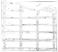
| SD7th FC6-74 |
|
Plan showing drainage streets, creeks, dykes [dikes] and main drainage ditches, 40th Ward Philadelphia, made for Bureau of Highways. Frederick T. Thorpe, Jr., Surveyor and Regulator, Seventh District, March 30, 1935 | Thorpe, Frederick T., Jr. | 1935 |
Tracing
25 x 38 in.
|
Southwest Philadelphia
Creeks and drainage streets, wharves, docks, proposed airport
|
| SD7th FC6-75-01 |
|
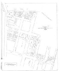
Plans showing existing surface drainage of a portion of the Eastwick Section. Made for the use of the Bureau of Highways. Fortieth Ward Phila. (13 sheets). Sheet No. 1. [Title block and index map] | Thorpe, Frederick T., Jr. | 1933 |
Tracing
36 x 40 in.
|
Southwest Philadelphia. Total area covered by the thirteen plans: bounded by Cobb's Creek, Darby Creek and 74th St. and Island Ave. Eastwick Ave. and 89th St.
Streams, drainage streets, ditches
|
| SD7th FC6-75-02 |
|
Sheet No. 2. [Plans showing existing surface drainage of a portion of the Eastwick Section. Made for the use of the Bureau of Highways. Fortieth Ward Phila.] | Thorpe, Frederick T., Jr. | 1933 |
Tracing
36 x 40 in.
|
Southwest Philadelphia. Total area covered by the thirteen plans: bounded by Cobb's Creek, Darby Creek and 74th St. and Island Ave. Eastwick Ave. and 89th St.
Streams, drainage streets, ditches
|
| SD7th FC6-75-03 |
|
Sheet No. 3. [Plans showing existing surface drainage of a portion of the Eastwick Section. Made for the use of the Bureau of Highways. Fortieth Ward Phila.] | Thorpe, Frederick T., Jr. | 1933 |
Tracing
36 x 40 in.
|
Southwest Philadelphia. Total area covered by the thirteen plans: bounded by Cobb's Creek, Darby Creek and 74th St. and Island Ave. Eastwick Ave. and 89th St.
Streams, drainage streets, ditches
|
| SD7th FC6-75-04 |
|
Sheet No. 4. [Plans showing existing surface drainage of a portion of the Eastwick Section. Made for the use of the Bureau of Highways. Fortieth Ward Phila.] | Thorpe, Frederick T., Jr. | 1933 |
Tracing
36 x 40 in.
|
Southwest Philadelphia. Total area covered by the thirteen plans: bounded by Cobb's Creek, Darby Creek and 74th St. and Island Ave. Eastwick Ave. and 89th St.
Streams, drainage streets, ditches
|
| SD7th FC6-75-05 |
|
Sheet No. 5. [Plans showing existing surface drainage of a portion of the Eastwick Section. Made for the use of the Bureau of Highways. Fortieth Ward Phila.] | Thorpe, Frederick T., Jr. | 1933 |
Tracing
36 x 40 in.
|
Southwest Philadelphia. Total area covered by the thirteen plans: bounded by Cobb's Creek, Darby Creek and 74th St. and Island Ave. Eastwick Ave. and 89th St.
Streams, drainage streets, ditches
|
| SD7th FC6-75-06 |
|
Sheet No. 6. [Plans showing existing surface drainage of a portion of the Eastwick Section. Made for the use of the Bureau of Highways. Fortieth Ward Phila.] | Thorpe, Frederick T., Jr. | 1933 |
Tracing
36 x 40 in.
|
Southwest Philadelphia. Total area covered by the thirteen plans: bounded by Cobb's Creek, Darby Creek and 74th St. and Island Ave. Eastwick Ave. and 89th St.
Streams, drainage streets, ditches
|
| SD7th FC6-75-07 |
|
Sheet No. 7. [Plans showing existing surface drainage of a portion of the Eastwick Section. Made for the use of the Bureau of Highways. Fortieth Ward Phila.] | Thorpe, Frederick T., Jr. | 1933 |
Tracing
36 x 40 in.
|
Southwest Philadelphia. Total area covered by the thirteen plans: bounded by Cobb's Creek, Darby Creek and 74th St. and Island Ave. Eastwick Ave. and 89th St.
Streams, drainage streets, ditches
|
| SD7th FC6-75-08 |
|
Sheet No. 8. [Plans showing existing surface drainage of a portion of the Eastwick Section. Made for the use of the Bureau of Highways. Fortieth Ward Phila.] | Thorpe, Frederick T., Jr. | 1933 |
Tracing
36 x 40 in.
|
Southwest Philadelphia. Total area covered by the thirteen plans: bounded by Cobb's Creek, Darby Creek and 74th St. and Island Ave. Eastwick Ave. and 89th St.
Streams, drainage streets, ditches
|
| SD7th FC6-75-09 |
|
Sheet No. 9. [Plans showing existing surface drainage of a portion of the Eastwick Section. Made for the use of the Bureau of Highways. Fortieth Ward Phila.] | Thorpe, Frederick T., Jr. | 1933 |
Tracing
36 x 40 in.
|
Southwest Philadelphia. Total area covered by the thirteen plans: bounded by Cobb's Creek, Darby Creek and 74th St. and Island Ave. Eastwick Ave. and 89th St.
Streams, drainage streets, ditches
|
| SD7th FC6-75-10 |
|
Sheet No. 10. [Plans showing existing surface drainage of a portion of the Eastwick Section. Made for the use of the Bureau of Highways. Fortieth Ward Phila.] | Thorpe, Frederick T., Jr. | 1933 |
Tracing
36 x 40 in.
|
Southwest Philadelphia. Total area covered by the thirteen plans: bounded by Cobb's Creek, Darby Creek and 74th St. and Island Ave. Eastwick Ave. and 89th St.
Streams, drainage streets, ditches
|
| SD7th FC6-75-11 |
|
Sheet No. 11. [Plans showing existing surface drainage of a portion of the Eastwick Section. Made for the use of the Bureau of Highways. Fortieth Ward Phila.] | Thorpe, Frederick T., Jr. | 1933 |
Tracing
36 x 40 in.
|
Southwest Philadelphia. Total area covered by the thirteen plans: bounded by Cobb's Creek, Darby Creek and 74th St. and Island Ave. Eastwick Ave. and 89th St.
Streams, drainage streets, ditches
|
| SD7th FC6-75-12 |
|
Sheet No. 12. [Plans showing existing surface drainage of a portion of the Eastwick Section. Made for the use of the Bureau of Highways. Fortieth Ward Phila.] | Thorpe, Frederick T., Jr. | 1933 |
Tracing
36 x 40 in.
|
Southwest Philadelphia. Total area covered by the thirteen plans: bounded by Cobb's Creek, Darby Creek and 74th St. and Island Ave. Eastwick Ave. and 89th St.
Streams, drainage streets, ditches
|
| SD7th FC6-75-13 |
|
Sheet No. 13. [Plans showing existing surface drainage of a portion of the Eastwick Section. Made for the use of the Bureau of Highways. Fortieth Ward Phila.] | Thorpe, Frederick T., Jr. | 1933 |
Tracing
36 x 40 in.
|
Southwest Philadelphia. Total area covered by the thirteen plans: bounded by Cobb's Creek, Darby Creek and 74th St. and Island Ave. Eastwick Ave. and 89th St.
Streams, drainage streets, ditches
|
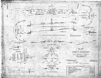
| SD7th FC7-37 |
|
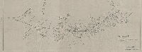
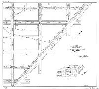
Calculation sheet, revision of portion of 40th Ward Phila. Scale 1"=200'. Bureau of Surveys, General Plans Division. October 9, 1918. April 17, 1919. | Briggs, ? | 1918 |
Tracing
30 X 82 in.
|
Southwest Philadelphia. Essington Ave., 84th St., Gibson Ave. and Philadelphia, Baltimore and Washington Railroad.
Mingo Creek, Eel Creek, Lands Creek, Church Creek, drainage street
|
| SD7th-1-10B-370 |
|
Properties in the vicinity of the Falls R.R. Bridge [On reverse: "Fairmount Park, Falls of Schuylkill. Case 1, Box 10B, No. 370"] | Not named | 1868 ca. |
Tracing
14 x 45 in.
Not noted
|
West Philadelphia, near Falls Bridge
Property lines and owners. These properties eventually became part of Fairmount Park - they correspond to the published "Farms and Lots" map.
|
| SD7th-1-10B-435 |
|
Plan showing additional right of way to be acquired for a branch of the Philadelphia & Reading Rail Road through the Joseph Rubincam Estate. 24th Ward Philada. Area 3.05 acres. [On reverse: "Case 1, Box 10B, No. 435."] | Not named | 1868 ca. |
Tracing
11 x 45 in.
1 inch = 50 feet
|
West Philadelphia, near Falls Bridge
Property lines, Reading Railroad, building footprints including tenement and boat house, stream, Schuylkill River, towpath
|
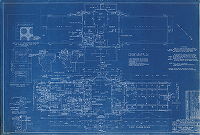
| SD7th-Airport-01-01 |
|
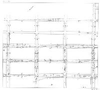
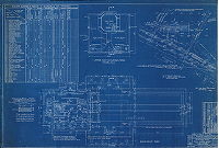
Administration building for S. Davis Wilson Air-Port, Island Ave. & Penrose Ave., Philadelphia, Penna. Building 1252, Drawing 1. Architectural. Upper roof and control tower, floor plan, basement plan, and plot plan. Horace W. Castor, R.A. Date: Aug 30, 1938. Revised by the Department of City Architecture, Oct. 26, 1938. | Castor, Horace W. | 1938 |
Blueprint
24 x 36 in.
1 inch = 8 feet
|
Philadelphia Airport, Southwest Philadelphia
Technical drawing, set of 12. This drawing includes schedule of finishes for each of the 52 rooms and two stairways.
|
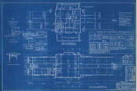
| SD7th-Airport-01-02 |
|
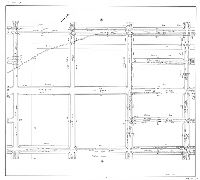
Administration building for S. Davis Wilson Air-Port, Island Ave. & Penrose Ave., Philadelphia, Penna. Building 1252, Drawing 2. Architectural. First floor, second floor, and lower roof plans, and detail of decorated ceiling. Horace W. Castor, R.A. Date: Aug 30, 1938. Revised by the Department of City Architecture, Oct. 26, 1938. | Castor, Horace W. | 1938 |
Blueprint
24 x 36 in.
1 inch = 8 feet
|
Philadelphia Airport, Southwest Philadelphia
Technical drawing, set of 12
|
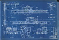
| SD7th-Airport-01-03 |
|
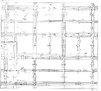
Administration building for S. Davis Wilson Air-Port, Island Ave. & Penrose Ave., Philadelphia, Penna. Building 1252, Drawing 3. Architectural. Building elevations from four sides.. Horace W. Castor, R.A. Date: Aug 30, 1938. Revised by the Department of City Architecture, Oct. 26, 1938. | Castor, Horace W. | 1938 |
Blueprint
24 x 36 in.
Varies
|
Philadelphia Airport, Southwest Philadelphia
Technical drawing, set of 12
|
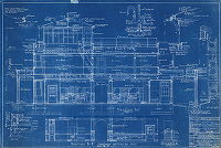
| SD7th-Airport-01-04 |
|
Administration building for S. Davis Wilson Air-Port, Island Ave. & Penrose Ave., Philadelphia, Penna. Building 1252, Drawing 4. Architectural. Building elevations. Horace W. Castor, R.A. Date: Aug 30, 1938. Revised by the Department of City Architecture, Oct. 26, 1938. | Castor, Horace W. | 1938 |
Blueprint
24 x 36 in.
Varies
|
Philadelphia Airport, Southwest Philadelphia
Technical drawing, set of 12
|
| SD7th-Airport-01-05 |
|
Administration building for S. Davis Wilson Air-Port, Island Ave. & Penrose Ave., Philadelphia, Penna. Building 1252, Drawing 5. Structural plans. Horace W. Castor, R.A. Date: Aug 30, 1938. Revised by the Department of City Architecture, Oct. 26, 1938. | Castor, Horace W. | 1938 |
Blueprint
24 x 36 in.
Varies
|
Philadelphia Airport, Southwest Philadelphia
Technical drawing, set of 12
|
| SD7th-Airport-01-06 |
|
Administration building for S. Davis Wilson Air-Port, Island Ave. & Penrose Ave., Philadelphia, Penna. Building 1252, Drawing 6. Structural plans. Horace W. Castor, R.A. Date: Aug 30, 1938. Revised by the Department of City Architecture, Oct. 26, 1938. | Castor, Horace W. | 1938 |
Blueprint
24 x 36 in.
Varies
|
Philadelphia Airport, Southwest Philadelphia
Technical drawing, set of 12
|
| SD7th-Airport-01-07 |
|
Administration building for S. Davis Wilson Air-Port, Island Ave. & Penrose Ave., Philadelphia, Penna. Building 1252, Drawing 7. Plumbing and heating plans, including septic tank and leaching well. Horace W. Castor, R.A. Date: Aug 30, 1938. Revised by the Department of City Architecture, Oct. 26, 1938. | Castor, Horace W. | 1938 |
Blueprint
24 x 36 in.
1 inch = 8 feet
|
Philadelphia Airport, Southwest Philadelphia
Technical drawing, set of 12
|
| SD7th-Airport-01-08 |
|
Administration building for S. Davis Wilson Air-Port, Island Ave. & Penrose Ave., Philadelphia, Penna. Building 1252, Drawing 8. Plumbing and heating plans, including sump and pump arrangement. Horace W. Castor, R.A. Date: Aug 30, 1938. Revised by the Department of City Architecture, Oct. 26, 1938. | Castor, Horace W. | 1938 |
Blueprint
24 x 36 in.
1 inch = 8 feet
|
Philadelphia Airport, Southwest Philadelphia
Technical drawing, set of 12
|
| SD7th-Airport-01-09 |
|
Administration building for S. Davis Wilson Air-Port, Island Ave. & Penrose Ave., Philadelphia, Penna. Building 1252, Drawing 9. Electrical plans. Horace W. Castor, R.A. Date: Aug 30, 1938. Revised by the Department of City Architecture, Oct. 26, 1938. | Castor, Horace W. | 1938 |
Blueprint
24 x 36 in.
1 inch = 8 feet
|
Philadelphia Airport, Southwest Philadelphia
Technical drawing, set of 12
|
| SD7th-Airport-01-10 |
|
Administration building for S. Davis Wilson Air-Port, Island Ave. & Penrose Ave., Philadelphia, Penna. Building 1252, Drawing 10. Electrical plans. Horace W. Castor, R.A. Date: Aug 30, 1938. Revised by the Department of City Architecture, Oct. 26, 1938. | Castor, Horace W. | 1938 |
Blueprint
24 x 36 in.
1 inch = 8 feet
|
Philadelphia Airport, Southwest Philadelphia
Technical drawing, set of 12
|
| SD7th-Airport-01-11 |
|
Administration building for S. Davis Wilson Air-Port, Island Ave. & Penrose Ave., Philadelphia, Penna. Building 1252, Drawing 11. Telephone and address system plans. Horace W. Castor, R.A. Date: Aug 30, 1938. Revised by the Department of City Architecture, Oct. 26, 1938. | Castor, Horace W. | 1938 |
Blueprint
24 x 36 in.
1 inch = 8 feet
|
Philadelphia Airport, Southwest Philadelphia
Technical drawing, set of 12
|