
Philadelphia Streets Department Surveys
2755 result(s). Showing results 2551 to 2600.
View page: 1 2 3 4 5 6 7 8 9 10 11 12 13 14 15 16 17 18 19 20 21 22 23 24 25 26 27 28 29 30 31 32 33 34 35 36 37 38 39 40 41 42 43 44 45 46 47 48 49 50 51 52 53 54 55 56 (Show all on one page)
| Identifer | Preview | Title | Surveyor | Date | Media / Size / Scale | Area / Map Features |
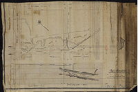
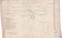
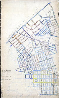
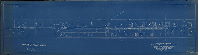
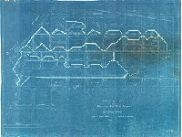
| SD7th-P15-F2-500 |
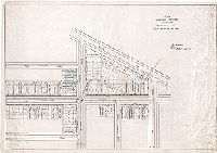
|
Plan showing sewers in vicinity of 38th and Brown St.'s. For the use of the Law Dep't. Jos. Johnson, Surveyor & Regulator, 11th Dist., August 10, 1899. | Johnson, Joseph | 1899 |
Tracing
22 x 31 in.
1 inch = 40 feet
|
West Philadelphia. Shows sewers and houses on 37th, 38th, Brown, Linwood, DeKalb Sts. And Mantua Ave.
Building footprints, property lines and owners with additions in pencil. Portion of this sewer collapsed in June 1899, and again in August 1899; this plan was likely made in relation to claims against the city relating to these collapses. Most of the bloc
|
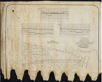
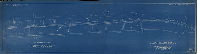
| SD7th-P15-F2-500-attachment |
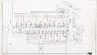
|
[No title. Plan attached to SD7th-P15-F2-500, showing detailed "conditions existing Jan. 2, 1901:--before stating work on sewer." All the figures are "low" which indicates settling of the filled land on which the houses were built.] | Not named | 1899 ca. |
Tracing
20 x 34 in.
1 inch = 20 feet
|
West Philadelphia. Houses along Brown St. between 37th St. and 38th St.
Building footprints, measurements of existing conditions indicating settlement of land.
|
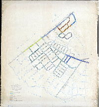
| SD7th-P15-F2-505-13 |
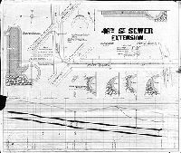
|
48th St. Sewer Extension. September 1879. | Smedley, Samuel L. | 1879 |
Blueprint
24 x 28 in.
1 inch = 50 feet
|
West Philadelphia. Route of Sewer on 48th St. from Wyalusing St. to Girard Ave., Girard from 48th St. to Merion Ave., Merion Ave. from Girard Ave. westward.
Profile of sewer and cross sections showing construction of pipe and wellhole. See PWD ERV 1073982, Plan No. 17b-814
|
| SD7th-P15-F2-506-1 |
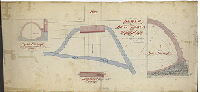
|
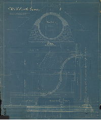
Sewer at 48th and Oregon [Brown] Sts. Approved by the Board of Surveyors, May 17, 1875 [Mill Creek Sewer] | Smedley, Samuel L. | 1876 |
Tracing
29 x 62 in.
1 inch = 16 feet
|
West Philadelphia, Mill Creek Sewer
Mill Creek (original and excavated channels), half section, cross section, and longitudinal section of the pipe; calculations in ink. Dated 7/28/76.
|
| SD7th-P15-F2-509-1 |
|
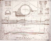
Mill Creek Sewer. [Title on reverse: Mill Creek Sewer from 46th and Haverford to 47th and Fairmount] | Not named | 1887 |
Blueprint
29 x 25 in.
1 inch = 50 feet
|
West Philadelphia. Fairmount Ave. to Haverford Ave, 46th St. to 47th St.
Plan showing curving section of sewer, building footprints of mill, section showing sewer construction.
|
| SD7th-P15-F2-510-1 |
|
Mill Creek Sewer at 47th [St.] to Haverford St. Revised plan and profile. July 27th, 1887. [Second (untitled) plan on sheet shows proposed sewer through property of Pennsylvania Hospital for the Insane] | Not named | 1887 |
Blueprint
17 x 30 in.
1 inch = 50 feet
|
West Philadelphia. Bounded by 46th St. to 47th St., Aspen St. to Market St.
Building footprints, original stream location, sewer specifications
|
| SD7th-P15-F2-510-2 |
|
Mill Creek Sewer on Meadow - 46th Street between Market and Haverford Sts. Approved by Board of Surveyors, September 15, 1890. [Copy made ca. 1964, probably in conjunction with reconstruction of the sewer at that time] | Trik, C. A., draughtsman | 1890 |
Photocopy
25 x 30 in.
1 inch = 60 feet
|
West Philadelphia.
Profiles and sections of sewer; location of Mill Creek through Pennsylvania Hospital for the Insane property; notes in red pencil made ca. 1964
|
| SD7th-P15-F2-510-3 |
|
Penna. Hospital for the Insane. [Showing Mill Creek running through the property along the line of Meadow (now 46th) St.] | Johnson, Joseph | 1890 ca. |
Tracing
15 x 19 in.
1 inch = 100 ft
|
West Philadelphia
Mill Creek, walls separating male and female sections of Pennsylvania Hospital for the Insane, sewers
|
| SD7th-P15-F2-513 |
|
Plan of main sewer constructed through property of the estate of A. M. Eastwick, dec'd., in the 27th Ward, Phila.. Authorized by ordinance of Councils of March 23, 1893 | Gillingham, J. Harvey | 1897 |
Tracing
18 x 26 in.
1 inch = 50 feet
|
Southwest Philadelphia. Andrew M. Eastwick property between 51st St. and 52nd St., Woodland Ave. to the Philadelphia, Wilmington and Baltimore Railroad
Building footprints, location of stream (Perch Creek) and ground levels prior to sewer construction.
|
| SD7th-P15-F2-514-1 |
|
Plan made for the use of the Road Jury in the matter of the construction of Mill Creek Sewer through property of Elisha C. and P. H. Warren (Sarah Lauretta Warren), 27th Ward Philadelphia. October 15, 1894 | Jones, William H. | 1894 |
Tracing
27 x 35 in.
1 inch = 50 feet
|
West Philadelphia: Triangle bounded by Woodland Ave., Woodward Ave., 42nd St. and Mill Creek
Building footprints, property lines and owners. Survey points show low-lying elevation of Warren property, along Mill Creek, which will need extensive filling to bring it to the street grade.
|
| SD7th-P15-F2-514-2 |
|
Plan made for the use of a Jury in the matter of the construction of the Mill Creek Sewer, 27th Ward, Phila. | Not named | [1897 ca.?] |
Tracing
32 x 29 in.
1 inch = 50 feet
|
West Philadelphia: Triangle bounded by Woodland Ave., Woodward Ave., 42nd St. and Mill Creek
Building footprints, property lines and owners. Survey points show low-lying elevation of property, along Mill Creek, which will need extensive filling to bring it to the street grade.
|
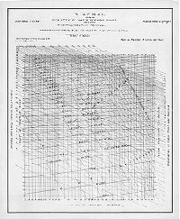
| SD7th-P1-F1-1 |
|
Diagram showing quantity of water reaching sewer based upon the Philadelphia Formula, corresponding grade, size and velocity when running full. Department of Public Works, Bureau of Surveys | Not named | 1915 ca. |
Tracing
31 x 25 in.
Not noted
|
|
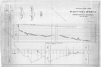
| SD7th-P8-F2 |
|
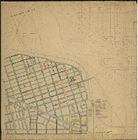
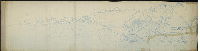
Plan and profile of Walnut Street from 22nd St. to 33rd St. Department of Public Works, Bureau of Surveys, Philadelphia, Pa. | Not named | 1900 ca. |
Blueprint
27 x 164 in.
1 inch = 25 feet
|
West Philadelphia, Walnut St. from 22nd St. to 33rd St.
Plan shows building footprints and accompanying elevations show detailed depictions of structures on both sides of the street. Label in lower right corner identifies this as plan "1356 2600" of the Bureau of Surveys Bridge Division.
|
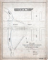
| SD7th-P8-F2-13 |
|
Plan showing the present location of Cobbs Creek together with the location prior to the construction of the new bridge in the 27th and 34th Ward Phila. | Johnson, Joseph, and Gillingham, J. Harvey |
Tracing
20 x 24 in.
1 inch = 20 feet
|
West Philadelphia. Cobb's Creek at 63rd St. and Market St.
Elevation of bridge carrying Market Street over Cobb's Creek; location of stream
|
|
| SD7th-P8-F2-25 |
|
Plan of preliminary survey for bridge on line of Forty-ninth Street over the Philadelphia Baltimore & Washington R.R., Fortieth Ward, Phila. | Gillingham, J. Harvey | 1916 |
Tracing
22 x 42 in.
1 inch = 20 feet
|
West Philadelphia, 49th St. between Paschall Ave. and Grays Ave.
Many building footprints, railroad tracks, utility locations, Grays Ferry Station and platform
|
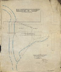
| SD7th-P8-F2-Bridges-588 |
|
Plan showing the present location of Cobbs Creek, together with the location prior to the construction of the new bridge in the 27th and 34th Ward Phila. [See also SD7th-B-588] | Johnson, Joseph | 1897 |
Tracing
27 x 23 in.
1 inch = 20 feet
|
West Philadelphia, Cobbs Creek and tributary, at 63rd St. and Market St.
Elevation of "old culvert over Cobbs Creek"
|
| SD7th-P9-F4-CP47-1 |
|
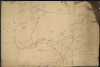
[No title. On reverse: "Copy of old plan of Sellers property. 803." Shows about 500 acres belonging to George Sellers, N & D Sellers, and other people, around 63rd and Market Streets in both Philadelphia and Delaware County.] | Not named | 1800 ca. |
Mounted
20 x 29 in.
Not noted
|
West Philadelphia, and Millbourne and Upper Darby, Delaware County.
Property lines and owners, big meadow, Naylor's Run, Cobb's Creek
|
| SD7th-P9-F4-CP47-2-obv |
|
Plan of E L I M [?] in the county of Delaware, surveyed 7 mo 20th 1860 by Joseph Fox. [Property of Joseph Powell, showing proposed street grid.] | Fox, Joseph | 1860 |
Paper
23 x 18 in.
Not noted
|
West Philadelphia and Upper Darby, Delaware County.
Cobb's Creek, property lines, street grid. Note reads: "Borrowed from Ed Shippen, now Wm. Lippincott's treas'r. Burd Orphan Asylum, 1717 Spruce St." On reverse: "To be returned to J. Harvey Gillingham, 12[th] Survey District.
|
| SD7th-P9-F4-CP47-2-rev |
|
[Outline plan of Joseph Powell property in Upper Darby, Pennsylvania, from which street plan on obverse was created.] | Fox, Joseph | 1860 |
Paper
23 x 18 in.
Not noted
|
West Philadelphia and Upper Darby, Delaware County.
Property lines and owners
|
| SD7th-Paschall-01 |
|
[On reverse: "Copies of Paschall's plans. 8 different surveys by W. H. Jones and John Gibson"] | Jones, William H., and Gibson, John | 1871- |
Tracing
25 x 37 in.
|
Southwest Philadelphia
Plans of properties for Henry Mackemson, 1871; Mary? Paschall, 1853; Thomas Lodge and the Point Breeze Rail Road Co., 1879; lots laid out by William Laycock, 1882?; lots by M. M. Sheldrake, 1874. Many other names appear on these plans.
|
| SD7th-Paschalll-2 |
|
Draft of a tract of land lying in the Township of Kingsessing in the County of Philadelphia and the State of Pennsylvania, the property of Benjamin Paschall, containing eighty-two acres twenty perches of land. Surveyed April 30th 1811. Thos. J. Paschall | Paschall, Thomas J. | 1811 |
Tracing
14 x 22 in.
1 inch = 15 perches
|
Southwest Philadelphia
Property plan. Justis Lane and Hay Road; pictograph of houses and trees; Charles' Creek, Mary's Creek, and other unnamed streams; land of William Hill and Charles and John M. Justis also indicated. This copy probably traced from original later in 19th cen
|
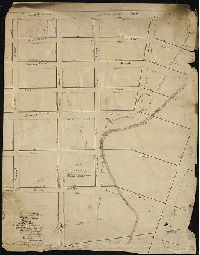
| SD7th-Paving-CP105 |
|
Plan colored to show character of cartway paving compiled from office records and field examinations. Feb. 13, 1912. Cartway widths shown in black. Small alleys and courts not shown. | Jones, W. H. | 1912, upd. 1928 ca. |
Mounted
38 x 38 in.
1 inch = 200 feet
|
West Philadelphia. City Plan area 105
Paving types shown include: granite or Belgian blocks, asphalt or asphalt blocks, granolithic, vitrified bricks or slag bricks, macadam, wood blocks, and cobble or rubble. Also shows topography with five-foot contours, railroads, soundings in Schuylkill R
|
| SD7th-Paving-CP143 |
|
Plan colored to show character of cartway paving compiled from office records and field examinations. Feb. 13, 1912. Cartway widths shown in black. Small alleys and courts not shown. | Not named | 1912, upd. 1944 ca. |
Mounted
62 x 38 in.
1 inch = 200 feet
|
West Philadelphia. City Plan area 143
Paving types shown include: granite or Belgian blocks, asphalt or asphalt blocks, granolithic, vitrified bricks or slag bricks, macadam, wood blocks, and cobble or rubble. Also shows topography with five-foot contours, Pennsylvania Hospital for the Insane
|
| SD7th-Paving-CP340-190 |
|
Plan colored to show character of cartway paving compiled from office records and field examinations. Feb. 13, 1912. Cartway widths shown in black. Small alleys and courts not shown. | Not named | 1912, upd. 1930 ca. |
Mounted
42 x 68 in.
1 inch = 200 feet
|
West Philadelphia. City Plan areas 340 and 190
Paving types shown include: granite or Belgian blocks, asphalt or asphalt blocks, granolithic, vitrified bricks or slag bricks, macadam, wood blocks, and cobble or rubble.
|
| SD7th-Paving-CP342 |
|
Plan colored to show character of cartway paving compiled from office records and field examinations. Feb. 13, 1912. Cartway widths shown in black. Small alleys and courts not shown. | Not named | 1912, upd. 1940 ca. |
Mounted
68 x 42 in.
1 inch = 200 feet
|
West Philadelphia. City Plan area 342
Paving types shown include: granite or Belgian blocks, asphalt or asphalt blocks, granolithic, vitrified bricks or slag bricks, macadam, wood blocks, and cobble or rubble.
|
| SD7th-Paving-CP343 |
|
Plan colored to show character of cartway paving compiled from office records and field examinations. Feb. 13, 1912. Cartway widths shown in black. Small alleys and courts not shown. | Not named | 1912, upd. 1951 ca. |
Mounted
45 x 41 in.
1 inch = 200 feet
|
West Philadelphia. City Plan area 343
Paving types shown include: granite or Belgian blocks, asphalt or asphalt blocks, granolithic, vitrified bricks or slag bricks, macadam, wood blocks, and cobble or rubble.
|
| SD7th-PlanBook2-Burnt48 |
|
Joseph F. Sinnott [property], March 20th, 1884. [Note in pencil reads: "Torn down 1926"] | Sinnott, Joseph F., possibly | 1884 |
Paper
18 x 12 in.
Not noted
|
West Philadelphia, 43rd St. between Walnut St. and Locust St.
Property plan with building footprints and uses
|
| SD7th-Property-Roberts |
|
Estates of Isaac W. and Algernon S. Roberts situated in the Counties of Philadelphia and Montgomery [Several copies, no single copy complete. Pieced together and restored in Photoshop] | Not named | 1880 ca. |
Blueprint
26 x 44 in.
1 inch = 200 feet
|
West Philadelphia
Property plan
|
| SD7th-RR-01 |

|
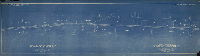
[No title. Plan of Philadelphia, Baltimore and Washington Railroad from Schuylkill River to Cobb's Creek. On reverse: "P.B. & W. R.R. between Paschall and Grays, 42nd to Cobb Creek"] | Brooks, H. L. | 1907 |
Blueprint
9 x 97 in.
1 inch = 200 feet
|
Southwest Philadelphia
Includes chart with "Railroad History" that includes the old P.W. & B, Junction Railroad, P. B. and C. (Philadelphia, Baltimore and Central), the Schuylkill River Branch of the Pennsylvania Railroad, and the West Philadelphia Elevated Branch
|
| SD7th-RR-02 |
|
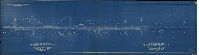
No. 16900. P.B. and W. R.R. [Philadelphia, Baltimore and Washington Railroad and Sixtieth St. and S. Chester Branches. Scale 1"=1000'. Engineering Department - P. R. R. [Pennsylvania Railroad], Philadelphia, PA, Feb. 1st, 1918 | Not named | 1918 |
Blueprint
28 x 117 in.
1 inch = 1000 feet
|
From Schuylkill River at 46th Street to Claymont, Delaware
A comprehensive overview of railroad lines in this vicinity, including many details along the lines: industrial plants, wharves, Hog Island Shipyard, as well as other adjacent rail lines.
|
| SD7th-RR-03-1 |
|
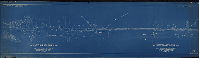
Philadelphia & Reading Railway. Plan showing tracks and properties on the Philadelphia & Chester Branch, prior to Dec. 11, 1917: Date or ordinance authorizing additional tracks. Station 0 - Grays Ferry Phila. Chief Engineer's Office. P-2028, Dec. 11, 1917. 6 sheets, Sheet No. 1 [Subsidiary title: Philadelphia, Wilmington & Baltimore R.R. (Chester Branch). 40th Ward, City of Philadelphia] | Not named | 1917 |
Blueprint
18 x 63 in.
1 inch = 100 feet
|
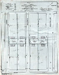
Southwest Philadelphia. Tracks between Grays Ferry Ave. or 49th St. and 58th St.
Property owners, building footprints with building uses, including factories, dwellings, sheds, tanks, ruins; other rail lines and sidings in vicinity; streams, ditches, fill areas. Each of the six contiguous plans in this series covers one mile of track.
|
| SD7th-RR-03-2 |
|
Philadelphia & Reading Railway. Plan showing tracks and properties on the Philadelphia & Chester Branch, prior to Dec. 11, 1917: Date or ordinance authorizing additional tracks. Station 0 - Grays Ferry Phila. Chief Engineer's Office. P-2028, Dec. 11, 1917. 6 sheets, Sheet No. 2 [Subsidiary title: Philadelphia, Wilmington & Baltimore R.R. (Chester Branch). 40th Ward, City of Philadelphia] | Not named | 1917 |
Blueprint
18 x 63 in.
1 inch = 100 feet
|
Southwest Philadelphia. Tracks between 58th St. and 67th St. paralleling Eastwick Ave.
Property owners, building footprints with building uses, including factories, dwellings, sheds, tanks, ruins; other rail lines and sidings in vicinity; streams, ditches, fill areas. Each of the six contiguous plans in this series covers one mile of track.
|
| SD7th-RR-03-3 |
|
Philadelphia & Reading Railway. Plan showing tracks and properties on the Philadelphia & Chester Branch, prior to Dec. 11, 1917: Date or ordinance authorizing additional tracks. Station 0 - Grays Ferry Phila. Chief Engineer's Office. P-2028, Dec. 11, 1917. 6 sheets, Sheet No. 3 [Subsidiary title: Philadelphia, Wilmington & Baltimore R.R. (Chester Branch). 40th Ward, City of Philadelphia] | Not named | 1917 |
Blueprint
18 x 63 in.
1 inch = 100 feet
|
Southwest Philadelphia. Tracks between 68th St. and 77th St. paralleling Eastwick Ave.
Property owners, building footprints with building uses, including factories, dwellings, sheds, tanks, ruins; other rail lines and sidings in vicinity; streams, ditches, fill areas. Each of the six contiguous plans in this series covers one mile of track.
|
| SD7th-RR-03-4 |
|
Philadelphia & Reading Railway. Plan showing tracks and properties on the Philadelphia & Chester Branch, prior to Dec. 11, 1917: Date or ordinance authorizing additional tracks. Station 0 - Grays Ferry Phila. Chief Engineer's Office. P-2028, Dec. 11, 1917. 6 sheets, Sheet No. 5 [Subsidiary title: Philadelphia, Wilmington & Baltimore R.R. (Chester Branch). 40th Ward, City of Philadelphia] | Not named | 1917 |
Blueprint
18 x 63 in.
1 inch = 100 feet
|
Southwest Philadelphia. Tracks between 77th St. to 86th St. paralleling Eastwick Ave.
Property owners, building footprints with building uses, including factories, dwellings, sheds, tanks, ruins; other rail lines and sidings in vicinity; streams, ditches, fill areas. Each of the six contiguous plans in this series covers one mile of track.
|
| SD7th-RR-03-5 |
|
Philadelphia & Reading Railway. Plan showing tracks and properties on the Philadelphia & Chester Branch, prior to Dec. 11, 1917: Date or ordinance authorizing additional tracks. Station 0 - Grays Ferry Phila. Chief Engineer's Office. P-2028, Dec. 11, 1917. 6 sheets, Sheet No. 4 [Subsidiary title: Philadelphia, Wilmington & Baltimore R.R. (Chester Branch). 40th Ward, City of Philadelphia] | Not named | 1917 |
Blueprint
18 x 63 in.
1 inch = 100 feet
|
Southwest Philadelphia. Tracks between 86th St. and 93rd St. paralleling Eastwick Ave.
Property owners, building footprints with building uses, including factories, dwellings, sheds, tanks, ruins; other rail lines and sidings in vicinity; streams, ditches, fill areas. Each of the six contiguous plans in this series covers one mile of track.
|
| SD7th-RR-03-6 |
|
Philadelphia & Reading Railway. Plan showing tracks and properties on the Philadelphia & Chester Branch, prior to Dec. 11, 1917: Date or ordinance authorizing additional tracks. Station 0 - Grays Ferry Phila. Chief Engineer's Office. P-2028, Dec. 11, 1917. 6 sheets, Sheet No. 6 [Subsidiary title: Philadelphia, Wilmington & Baltimore R.R. (Chester Branch). 40th Ward, City of Philadelphia] | Not named | 1917 |
Blueprint
18 x 63 in.
1 inch = 100 feet
|
Southwest Philadelphia. Tracks between 93rd St. and Lester, Pennsylvania
Property owners, building footprints with building uses, including factories, dwellings, sheds, tanks, ruins; other rail lines and sidings in vicinity; streams, ditches, fill areas. Each of the six contiguous plans in this series covers one mile of track.
|
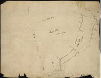
| SD7th-SD-2-34 |
|
Drainage area, Charles Creek System, 12th Dist. | Not named | 1896 ca. |
Blueprint
30 x 40 in.
1 inch = 400 feet
|
Southwest Philadelphia. Bounded roughly by Schuylkill River to Kingsessing Ave., 56th St. to 73rd St. and Island Rd.
Proposed sewers with sizes and locations "dyke" or dike along Schuylkill River
|
| SD7th-SD-2-37 |
|
Drainage area of Woodland Ave. Main Sewer. 12th Survey District. Dept. of Public Works, Bureau of Surveys, June 1896 | Not named | 1896 |
Blueprint
21 x 28 in.
Not noted
|
Southwest Philadelphia. Bounded roughly by Kingsessing Ave. to Philadelphia, Wilmington and Baltimore Railroad, 6th St. to Cobbs Creek and Island Rd.
Proposed and existing sewers with sizes and locations
|
| SD7th-SD-2-40 |
|
Proposed main sewer in Sixty-ninth Street from Elmwood Ave. to Dicks Ave. in the Fortieth Ward | Gillingham, J. Harvey | 1907 |
Tracing
34 x 51 in.
1 inch = 30 feet
|
Southwest Philadelphia
Plan and profile of sewer meant to capture small stream, probably either Charles Creek or a tributary to this stream.
|
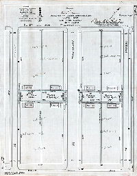
| SD7th-SP01 |
|
Plan of small parks dedicated by the U.S. Shipping Board, made for lighting survey, 40th Ward, Philadelphia | Thorpe, Frederick T., Jr. | 1933 |
Tracing
9 x 22 in.
1 inch = 30 feet
|
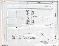
Southwest Philadelphia, on 70th St. between Buist Ave. and Dicks Ave.
Park outlines with locations of nearby buildings, electric lamps, gas lights, gasoline or naptha lamps, trees, hedges, telephone poles, shrubbery, and other features.
|
| SD7th-SP02 |
|
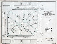
Plan of George Connell Park, made for lighting survey, Department of Public Works, Fortieth Ward, Philadelphia. | Thorpe, Frederick T., Jr. | 1933 |
Tracing
17 x 22 in.
1 inch = 40 feet
|
Southwest Philadelphia, Grays Ave. to Elmwood Ave., 64th sty. to 65th St.
Park outlines with locations of nearby buildings, electric lamps, gas lights, gasoline or naptha lamps, trees, hedges, telephone poles, shrubbery, and other features.
|
| SD7th-SP03 |
|
Plan of small parks dedicated by the U.S. Shipping Board, made for lighting survey, 40th Ward, Philadelphia | Thorpe, Frederick T., Jr. | 1933 |
Tracing
17 x 22 in.
1 inch = 30 feet
|
Southwest Philadelphia, Buist Ave. to Dicks Ave., Carroll St. to 68th St., 68th to Hobson St.
Park outlines with locations of nearby buildings, electric lamps, gas lights, gasoline or naptha lamps, trees, hedges, telephone poles, shrubbery, and other features.
|
| SD7th-SP04 |
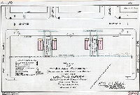
|
Plan of small parks (dedicated by U.S. Shipping Board) made for lighting survey, Department of Public Works, Fortieth Ward, Philadelphia | Thorpe, Frederick T., Jr. | 1933 |
Tracing
11 x 17 in.
1 inch = 30 feet
|
Southwest Philadelphia, Dicks Ave. between 72nd St. to 73rd St.
Park outlines with locations of nearby buildings, electric lamps, gas lights, gasoline or naptha lamps, trees, hedges, telephone poles, shrubbery, and other features.
|
| SD7th-SP05 |
|
Plan of small parks made for lighting survey, Department of Public Works, Fortieth Ward, Philadelphia. (Dedicated by U.S. Shipping Board) | Thorpe, Frederick T., Jr. | 1933 |
Tracing
17 x 11 in.
1 inch = 30 feet
|
Southwest Philadelphia, Theodore St. and Buist Ave. between 71st St. and 72nd St.
Park outlines with locations of nearby buildings, electric lamps, gas lights, gasoline or naptha lamps, trees, hedges, telephone poles, shrubbery, and other features.
|
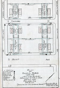
| SD7th-SP06 |
|
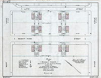
Plan of small parks (dedicated by U.S. Shipping Board) made for lighting survey, Department of Public Works, Fortieth Ward, Philadelphia | Thorpe, Frederick T., Jr. | 1933 |
Tracing
17 x 22 in.
1 inch = 30 feet
|
Southwest Philadelphia, Hobson St. to Bonnaffon St., Bonnaffon St. to 67th St.
between Elmwood Ave. and Buist Ave.
Park outlines with locations of nearby buildings, electric lamps, gas lights, gasoline or naptha lamps, trees, hedges, telephone poles, shrubbery, and other features.
|
| SD7th-SP07 |
|
Plan of small parks (dedicated by U.S. Shipping Board) made for lighting survey, Department of Public Works, Fortieth Ward, Philadelphia | Thorpe, Frederick T., Jr. | 1933 |
Tracing
17 x 22 in.
1 inch = 30 feet
|
Southwest Philadelphia, On 68th St. and Carroll St. between Elmwood Ave. and Buist Ave
Park outlines with locations of nearby buildings, electric lamps, gas lights, gasoline or naptha lamps, trees, hedges, telephone poles, shrubbery, and other features.
|
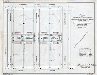
| SD7th-SP08 |
|
Plan of Elmwood park made for lighting survey, Department of Public Works, Fortieth Ward, Philadelphia | Thorpe, Frederick T., Jr. | 1933 |
Tracing
17 x 22 in.
1 inch = 50 feet
|
Southwest Philadelphia, Buist Ave. to Dicks Ave. 71st to 72nd St.
Park outlines with locations of nearby buildings, electric lamps, gas lights, gasoline or naptha lamps, trees, hedges, telephone poles, shrubbery, and other features.
|
| SD7th-SP09 |
|
Plan of small parks dedicated by the U.S. Shipping Board, made for lighting survey, Department of Public Works, 40th Ward, Philadelphia | Thorpe, Frederick T., Jr. | 1933 |
Tracing
22 x 17 in.
1 inch = 30 feet
|
Southwest Philadelphia, Hobson St. to Bonnaffon St., Bonnaffon to 67th St. between Buist Ave. and Dicks Ave
Park outlines with locations of nearby buildings, electric lamps, gas lights, gasoline or naptha lamps, trees, hedges, telephone poles, shrubbery, and other features.
|
| SD7th-SP10 |
|
Plan of small parks (dedicated by U.S. Shipping Board) made for lighting survey, Department of Public Works, Fortieth Ward, Philadelphia | Thorpe, Frederick T., Jr. | 1933 |
Tracing
17 x 22 in.
1 inch = 30 feet
|
Southwest Philadelphia, Lloyd St. to 63rd St. between Dicks Ave. and Buist Ave.
Park outlines with locations of nearby buildings, electric lamps, gas lights, gasoline or naptha lamps, trees, hedges, telephone poles, shrubbery, and other features.
|
| SD7th-SP11 |
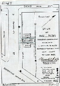
|
Plan of small parks dedicated by the U.S. Shipping Board, made for lighting survey, Department of Public Works, 40th Ward, Philadelphia | Thorpe, Frederick T., Jr. | 1933 |
Tracing
12 x 8 in.
1 inch = 40 feet
|
Southwest Philadelphia, Dicks Ave. to Passyunk Ave. on 70th St.
Park outlines with locations of nearby buildings, electric lamps, gas lights, gasoline or naptha lamps, trees, hedges, telephone poles, shrubbery, and other features.
|