
Philadelphia Streets Department Surveys
2755 result(s). Showing results 2601 to 2650.
View page: 1 2 3 4 5 6 7 8 9 10 11 12 13 14 15 16 17 18 19 20 21 22 23 24 25 26 27 28 29 30 31 32 33 34 35 36 37 38 39 40 41 42 43 44 45 46 47 48 49 50 51 52 53 54 55 56 (Show all on one page)
| Identifer | Preview | Title | Surveyor | Date | Media / Size / Scale | Area / Map Features |
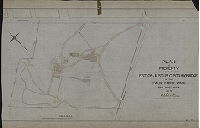
| SD7th-SP12 |

|
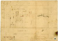
Plan of Buist Park made for lighting survey, Department of Public Works, Fortieth Ward, Philadelphia | Thorpe, Frederick T., Jr. | 1933 |
Tracing
17 x 11 in.
1 inch = 40 feet
|
Southwest Philadelphia, Northwest side of Buist Ave, between Hobson St. and 68th St.
Park outlines with locations of nearby buildings, electric lamps, gas lights, gasoline or naptha lamps, trees, hedges, telephone poles, shrubbery, and other features.
|
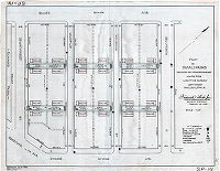
| SD7th-SP13 |

|
Plan of small parks (dedicated by U.S. Shipping Board) made for lighting survey, Department of Public Works, Fortieth Ward, Philadelphia | Thorpe, Frederick T., Jr. | 1933 |
Tracing
17 x 22 in.
1 inch = 30 feet
|
Southwest Philadelphia, 72nd St. to Lloyd St., Dicks Ave. to Passyunk Ave.
Park outlines with locations of nearby buildings, electric lamps, gas lights, gasoline or naptha lamps, trees, hedges, telephone poles, shrubbery, and other features.
|
| SD7th-SP14 |
|
Plan of small parks dedicated by the U.S. Shipping Board, made for lighting survey, 40th Ward, Philadelphia | Thorpe, Frederick T., Jr. | 1933 |
Tracing
17 x 22 in.
1 inch = 40 feet
|
Southwest Philadelphia, 71st St. to Muhfeld St., Muhfeld St. to Holbrook St.
Holbrook to 70th St. between Buist Ave. and Dicks Ave.
Park outlines with locations of nearby buildings, electric lamps, gas lights, gasoline or naptha lamps, trees, hedges, telephone poles, shrubbery, and other features.
|
| SD7th-SP15 |

|
Plan of small parks dedicated by the U.S. Shipping Board, made for lighting survey, Department of Public Works, 40th Ward, Philadelphia | Thorpe, Frederick T., Jr. | 1933 |
Tracing
17 x 22 in.
1 inch = 30 feet
|
Southwest Philadelphia, 71st St. to Muhfeld St., Muhfeld to Holbrook St.
between Passyunk Ave. and Grovers Ave.
Park outlines with locations of nearby buildings, electric lamps, gas lights, gasoline or naptha lamps, trees, hedges, telephone poles, shrubbery, and other features.
|
| SD7th-SP16 |

|
Plan of small parks (dedicated by U.S. Shipping Board) made for lighting survey, Department of Public Works, Fortieth Ward, Philadelphia | Thorpe, Frederick T., Jr. | 1933 |
Tracing
17 x 22 in.
1 inch = 30 feet
|
On Dicks Ave. and Guyer Ave. between 71st St. and 72nd St.
Park outlines with locations of nearby buildings, electric lamps, gas lights, gasoline or naptha lamps, trees, hedges, telephone poles, shrubbery, and other features.
|
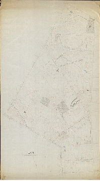
| SD7th-Topo-CP167 |
|
[No title. Topography of City Plan 167, probably by George Hancock] | Hancock, George W. | 1870 ca. |
Mounted
|
West Philadelphia. City Plan area 167
Topography
|
| SD7th-Topo-CP170 |
|
[No title. Topography of City Plan 170, probably by George Hancock] | Hancock, George W. | 1870 ca. |
Mounted
|
West Philadelphia. City Plan area 170
Topography
|
| SD7th-Topo-CP348 |
|
[No title. Topography of City Plan 248 probably by George Hancock] | Hancock, George W. | 1870 ca. |
Mounted
|
West Philadelphia. City Plan area 348
Topography
|
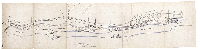
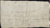
| SD7th-WS-BR7-12-1-1 |

|
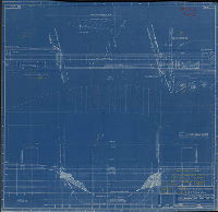
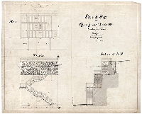
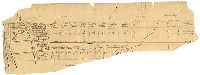
Plan showing the slopes and southeast approach to the Penrose Ferry Bridge, made for the Law Department, Philadelphia. | Gillingham, J. Harvey | 1899 |
Tracing
27 x 51 in.
1 inch = 20 feet
|
Schuylkill River at Penrose Ferry (now Platt) Bridge.
Profile view of bridge approach, property lines and owners, building footprints.
|
| SD7th-WS-CP152-108 |
|
Plan of property belonging to the estate of Dr. P. J. Hoopes, dec'd. May 26th, 1879. | Not named | 1879 |
Paper
10 x 14 in.
1 inch = 50 feet
|
Southwest Philadelphia. 72nd Street and Woodland Avenue.
Building Footprints, diagonal Ann Street shown with dotted lines.
|
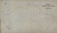
| SD7th-WS-CP152-3427 |
|
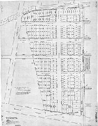
Plan of property in the 40th Ward, Phila., made for Henry Swartz. | Not named | 1926 |
Blueprint
17 x 22 in.
1 inch = 30 feet
|
Southwest Philadelphia. Triangle bounded by Chester Avenue, 68th Street, and Cobbs Creek Parkway
Property subdivision. Many notations in ink on each lot.
|
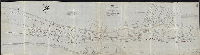
| SD7th-WS-CP293N-1 |

|
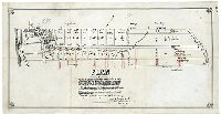
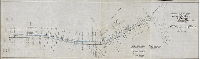
Plan showing present cross-sections of ditches to be dredged under an ordinance of Councils approved Dec. 31st 1900. Section 2. | Gillingham, J. Harvey | 1901 |
Tracing
48 x 52 in.
1 inch = 200 feet
|
Southwest Philadelphia. Bounded roughly by 81st Street, Darby Creek, Bow Creek, and Church Creek.
Shows many drainage ditches, creeks, and other waterways. Includes profiles showing widths and depths of the ditches.
|
| SD7th-WS-CP314-N-4 |

|
Plan showing location of National Transit Co. pipeline from 84th St. to Bow Creek, Fortieth Ward, Philadelphia. | Not named | 1923 |
Tracing
12 x 50 in.
1 inch = 200 feet
|
Southwest Philadelphia
Pipeline route, Bow Creek, many unbuilt streets shown as dotted lines.
|
| SD7th-WS-CP375-AB13 |
|
Plan of property in the Twenty-seventh Ward, Philadelphia, purchased by W. W. and N. W. Harkness | Not named | 1900 ca. |
Tracing
34 x 34 in.
Not noted
|
Southwest Philadelphia
Meadow property interlaced with creeks and drainage ditches. According to Hexamer General Survey Plate 903-904, N. W. Harkness owned an "oil yard" at Gibson's Point, around 57th St. and the Schuylkill River. The property shown on this plan begins downstre
|
| SD7th-WS-CP375-AB-19 |
|
Plan of meadow property in the Twenty-seventh Ward, Phila, made for Henry G. Morris | Not named | 1897 |
Tracing
39 x 30 in.
1 inch = 100 feet
|
Southwest Philadelphia
Meadow property along Schuylkill River, Lands Creek, river embankment
|
| SD7th-WS-CP375-AB-38 |
|
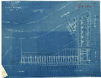
Submarine Pipe Type Cable Crossing, Schuylkill River at Penrose Avenue Bridge. 66 K.V. line from Southwark Station to Island Road Sub-station. Philadelphia Electric Co. B-141573. | Not named | 1951 ca. |
Blueprint
35 x 36 in.
1 inch = 40 feet
|
Schuylkill River at Penrose Ferry (now Platt) Bridge.
Electric company cable crossing. Shows depth of river.
|
| SD7th-WS-CP378-AD-6A |
|
Revised calculations, plan of building lots for B. W. Melvin, 414 Real Estate Trust Bldg., Philadelphia. Note: The original of this plan of the Thrifty Development Co. is recorded in Plan Book 1, page 29. | Not named | 1915 ca. |
Positive blueprint
36 x 29 in.
1 inch = 50 feet
|
Southwest Philadelphia
Property subdivision.
|
| SD7th-WS-CP378-AD-6B |

|
Revised calculations, plan of building lots for B. W. Melvin, 414 Real Estate Trust Bldg., Philadelphia. Note: The original of this plan of the Thrifty Development Co. is recorded in Plan Book 1, page 29. | Not named | 1915 ca. |
Tracing
36 x 29 in.
1 inch = 50 feet
|
Southwest Philadelphia
Property subdivision.
|
| SD7th-WS-CP387-11 |
|
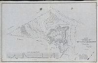
Plan of topographical survey of a portion of Fort Mifflin Reservation, Fortieth Ward, Philadelphia | Thorpe, Frederick T., Jr. | 1930 |
Tracing
36 x 56 in.
1 inch = 50 feet
|
Southwest Philadelphia
Fort Mifflin and surrounding marshland, Back Channel, cinder road and plank road.
|
| SD7th-WS-CP387-AE1-30 |
|
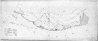
[No title. Plan of Delaware riverfront property downstream from mouth of Schuylkill River.] | Not named | 1910 ca. |
Tracing
28 x 65 in.
Not noted
|
Southwest Philadelphia
Tinicum, Little Smith, Maiden and Hog islands, property lines and owners, Fort Mifflin, Penrose Ferry Bridge. Chart sums up total acreage of properties shown.
|
| SD7th-WS-CP402-2G |

|
Plan of a portion of Penrose Tract 1A, Fortieth Ward, Philadelphia, Pa., for grading, drainage and appurtenant work, made for the Philadelphia Industrial Development Corp'n. | Albright & Friel | 1961 |
Tracing
37 x 60 in.
1 inch = 40 feet
|
Southwest Philadelphia
Shows cutting down of ground along Penrose Avenue near the Schuylkill River, perhaps because fill was needed nearby. Bottom portion cut off.
|
| SD9th-244Topo |
|
Plan of topography [for City Plan 244] | Not named | 1890 |
Tracing
78 x 43 in.
Not noted
|
Bounded roughly by Washington Lane, County Line Rd., 21st St., Stenton Ave. and Chelten Ave.
Topography, wooded areas, quarries, pond, streams, building footprints, tree-lined driveways
|
| SD9th-BuiltUp-1923 |

|
Built-up section map, City of Philadelphia, January 1, 1923. | Not named | 1923 |
Linaura
22 x 29 in.
Not noted
|
Philadelphia
Delineates built up areas by several designations: industrial; residential and retail; churches, schools, public buildings and institutions; parks, squares, and cemeteries; and undeveloped.
|
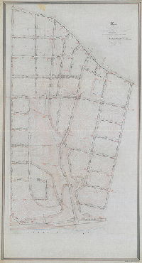
| SD9th-CP296-01 |
|
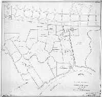
Plan of the survey and regulation of the Twentieth Section, Twenty-first Ward, City of Philadelphia [Resolution, April 5, 1876; confirmed Nov. 21, 1887. [See 296-1_MTD for original mounted plan, in fair condition.] | Levering, John H. | 1876 |
Tracing
77 x 42 in.
1 inch = 100 feet
|
Roxborough, 21st Ward, 20th Section. Bounded by Ridge Ave. to Manayunk Canal, Port Royal Ave. to Wigard Ave.
Topography, streams, springs, building footprints, Lower Roxborough Reservoir. Copy made ca. 1934 by John Kennedy, CWA (Civil Works Administration)
|
| SD9th-CS-035 |
|
[Manayunk Canal] Scale 200 feet = 1 inch. N. B. That wherever the letter S occurs at an angel or on a line in the above plan a marble stone has been fixed by me John Levering, 1847. Tracing by H. H. Platt. | Levering, John | 1847 |
Tracing
15 x 58 in.
1 inch = 200 feet
|
Manayunk and Roxborough. Schuylkill River, Canal, and several blocks along the riverfront, from Flat Rock Dam to Shur's Lane.
Building footprints, including many factories (with owners named) and several buildings of the Schuylkill Navigation Co., mill races, canal, locks, towpath, bridges, islands and rocks in Schuylkill River, Philadelphia and Norristown Railroad
|
| SD9th-CS-040 |
|
Plan of part of the Manayunk Canal and lots of ground adjacent belonging to the Schuylkill Navigation Co. Surveyed for the Co. May 1853 by John Levering. [Tracing copy made by "H. H. P." (H. H. Platt)] | Levering, John | 1853 |
Tracing
14 x 37 in.
Not noted
|
Manayunk. Schuylkill River, Canal, and several blocks along the riverfront, from Green Lane to Shur's Lane.
Building footprints, including factories (with owners named) and many buildings of the Schuylkill Navigation Co., mill races, canal, locks, towpath, bridges
|
| SD9th-CS-043 |

|
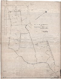
Plan of property in Roxborough, Twenty-first Ward, Philadelphia, surveyed for Charles Thomson Jones, Esq., July 1874 | Levering, John | 1874 |
Tracing
26 x 46 in.
1 inch = 60 feet
|
Roxborough, bounded roughly by Jennett Ave. to Wissahickon Turnpike (or Wissahickon Creek), Monastery Ave. (or tributary to Wissahickon Creek) to Leverington Ave.
Property subdivision.
|
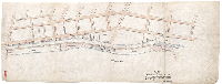
| SD9th-CS-055 |
|
Plan of steps at Church [now Krams Ave.] and Wood [now Silverwood] Sts., Twenty-first Ward. March 1897. C. S. Sundstrom, Surveyor 8th Dist. Scale 1/4" = 1' | Sundstrom, C. A. | 1897 |
Tracing
25 x 31 in.
1 inch = 4 feet
|
Roxborough.
Plan, section and elevation of wooden steps
|
| SD9th-CS-070 |
|
Plan of property belonging to the Matthew Gorgas Estate situated in Roxborough, Philadelphia. September 1893 | Sundstrom, C. A. | 1893 |
Tracing
35 x 59 in.
1 inch = 60 feet
|
Roxborough. Property bounded roughly by Ridge Ave., Gorgas Lane and Fairmount park boundary
Streams, building footprints, delineation of trees, garden, walkways and possibly an orchard
|
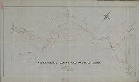
| SD9th-CS-092 |
|
[No title. Plan of Shawmont, showing many details of roads, railroads, structures, Schuylkill River bank, and streams. | Not named | 1880 ca. |
Tracing
24 x 58 in.
1 inch = 30 feet
|
Shawmont, between River Road and the Schuylkill River
Many building footprints including Shawmont Pumping Station of Philadelphia Water Dept.; Knickerbocker Ice Co, Johnson's boat house, Shawmont Station, F. Carpenter's Coal Yard, Thomas Shaw; Philadelphia & Reading Railroad and Pennsylvania Schuylkill Valle
|
| SD9th-CS-096 |

|
Part of Manayunk laid out for T. B. & J. Darrach by E. H. Gill, Civil Engineer. 1854 | Gill, E. H. | 1854 |
Mounted
15 x 29 in.
1 inch = 60 feet
|
Manayunk, bounded by Mallard St. to Baldwin St., Hamilton St. to Webster St.
Property subdivision, with adjacent property owners noted.
|
| SD9th-CS-116A |

|
Kenilworth Residence Sites, Upsal Station Penna. R.R., Germantown, Phila. May 1906 | Sundstrom, C. A. | 1906 |
Tracing
26 x 18 in.
1 inch = 100 feet
|
Germantown
Property subdivision
|
| SD9th-CS-116B |

|
Kenilworth Residence Sites, Upsal Station Penna. R.R., Germantown, Phila. Feb. 27th, 1901. Lots laid out by the owners. Plan and calculations made by C. A. Sundstrom, Surveyor and Regulator, 8th Dist. | Sundstrom, C. A. | 1901 |
Tracing
24 x 30 in.
1 inch = 100 feet
|
Germantown
Property subdivision
|
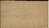
| SD9th-CS-147-1 |

|
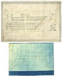
Use District Map. Philadelphia Zoning Commission, City of Philadelphia, Department of Public Works. [Two separate printed plans, Section 2 and Section 3, trimmed at the seam and pasted together] | Not named | 1921 |
Paper
32 x 28 in.
1 inch = 1000 feet
|
Philadelphia, north of the Line of Wharton St. and West of the line of I St.
Zoning designations indicated by shading: Residential Streets, Commercial Streets, Industrial Areas, Least Restricted Areas. This plan was in an envelope with many others related to improving the entrance to Fairmount Park at Rittenhouse Street.
|
| SD9th-CS-217 |

|
Plan No. 2, estate of James B. Winpenny, dec'd., Roxborough, 21st Ward, Philadelphia. John J. Thomas, administrator. | Not named | 1882 ca. |
Tracing
12 x 25 in.
1 inch = 60 feet
|
Roxborough, property around Manayunk Avenue and Jefferson St.
Property subdivision, with footprints of original mansion, barn and house, and adjacent property owners. Winpenny committed suicide in the wood-house outside his home on Bolton Ave. on June 5, 1882, according to the Philadelphia Times of June 6, 1882.
|
| SD9th-CS-221A |
|
Plan of a tract of land in Roxborough in the 21st Ward of the City of Philadelphia, the estate of George W. Smick dec'd. to be sold at public sale without any reserve on the premises on Thursday Dec'r. 16th 1858 at 12 o'clock precisely by order of the heirs....James A. Freeman, Auct'r. 422 Walnut St. Philada. | Not named | 1858 |
Tracing
14 x 27 in.
1 inch = 200 feet
|
Roxborough, property on both sides of Hermitage St. from the Manayunk Canal to Ridge Ave.
Property subdivision, auctioneer's notice. With prices paid for each lot and owner's name.
|
| SD9th-CS-221B |
|
[Fragment of original lithograph of plan noted in SD9th-CS-221A] | Not named | 1858 |
Paper
Fragment
|
Roxborough, property on both sides of Hermitage St. from the Manayunk Canal to Ridge Ave.
Property subdivision, auctioneer's notice. With prices paid for each lot and owner's name.
|
| SD9th-CS-237 |
|
Plan showing trees and proposed arrangement of gutters on Kitchen's Lane | Sundstrom, C. A. | 1915 |
Tracing
15 x 50 in.
1 inch = 40 feet
|
Roxborough, Kitchen's Lane from Wissahickon Ave. to North Mt. Pleasant Ave.
Shows location and diameter of all trees in this stretch of roadway, and which are above or below grade and to be protected by dry walls, and which are to be removed. Lamp posts, hedges, footway, and rustic railing also shown.
|
| SD9th-CS-285 |
|
Plan of lots at Wissahickon surveyed March 20, 1883 [Two plans, both reduced size: blueprint of original, and tracing. These may have been attached to a larger plan - CHECK FILES] | Levering, John H. | 1883 |
Tracing
8 x 11 in.
Not noted
|
Wissahickon, bounded by Osborn St. to Sumac St., Ridge Ave. to Righter St.
Property subdivision
|
| SD9th-CS-403 |
|
[Surveyed 1854 by John Levering. Copy May 1871, J. H. L. U.S. Standard Measure [On reverse: "Leverington Avenue Lots 1854"] | Levering, John H. | 1854 |
Paper
7 x 25 in.
1 inch = 100 feet
|
Leverington Avenue, Roxborough, starting at Ridge Rd.
Property subdivision
|
| SD9th-CS-Case49-6A |
|
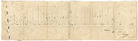
Surveyed by W. H. Dechant, Asst Eng. Canals, 1875 [Detailed delineation of Manayunk Canal from about Leverington Ave. to below Green Lane Bridge] | Dechant, W. H. | 1875 |
Tracing
19 x 35 in.
1 inch = 40 feet
|
Manayunk Canal
Mill property and footprints with owners, sluice, waste weir and other canal details. W. H. Dechant worked for the Philadelphia and Reading Railroad, which leased the waterways of the Schuylkill Navigation Company (of which the Manayunk Canal was a part)
|
| SD9th-CS-Case49-6B |

|
Survey by Wm. H. Dechant, Asst. Engr Canals, 1875, revised and corrected to June 1903 | Dechant, W. H. | 1903 |
Blueprint
24 x 36 in.
1 inch = 40 feet
|
Manayunk Canal
Mill property and footprints with owners, sluice, waste weir and other canal details.
|
| SD9th-CS-II-D-7 |
|
Map of the Manayunk Canal in the 21st Ward of the City of Philadelphia, with the lands of the Sch. Nav. Co. [Schuylkill Navigation Co.] adjacent. 1859. | Schopp, Philip | 1859 |
Tracing
19 x 72 in.
1 inch = 100 feet
|
Manayunk and canal, with details of Schuylkill River bank.
Building footprints, rock formations in bed of Schuylkill River, railroad, property owners and factory names. This is possibly a tracing copy of the original map.
|
| SD9th-II-A-27 |

|
Plan of Wissahickon Summit. [Promotional text: "…600' from the beautiful Wissahickon Creek...the Switzerland of Eastern Penna. … Most of the land along this stream is owned by people of large means. This is the first chance people of moderate means have had to get a foothold in this Section. Lots 2' x 100. Price $90 - $275. $2 secures a lot. Weekly or monthly payments thereafter. Agent on the land: Samuel Crothers, 1211 Walnut St."] | Not named | 1905 ca. |
Tracing
19 x 36 in.
Not noted
|
Roxborough. Bounded roughly by Greenway St. to Summit Ave., Ridge Ave. to Magdalena St.
Property subdivision. Development plan with promotional text.
|
| SD9th-II-A-41 |
|
[No title. Plan of streets and industrial buildings along the Manayunk Canal of the Schuylkill Navigation Co. Manayunk, from above Jackson Street to Cotton Street. This plan is contiguous with SD9TH-II-A-42] | Not named | 1890 ca. |
Mounted
19 x 34 in.
1 inch = 40 feet
|
Manayunk, along canal from roughly Jackson St. to Cotton St.
Building and factory footprints, bridges, canal, Main St.
|
| SD9th-II-A-42 |

|
[No title. Plan of streets and industrial buildings along the Manayunk Canal of the Schuylkill Navigation, from above Mechanic Street to below Cedar Street. This plan is contiguous with SD9TH-II-A-41] | Not named | 1890 ca. |
Mounted
20 x 36 in.
1 inch = 40 feet
|
Manayunk, along canal from roughly Mechanic St. to Cedar St.
Building and factory footprints with owners' names, bridges, canal, locks Main St.
|
| SD9th-II-D-1-2 |
|
Topography along Monoshone Creek | Sundstrom, C. A. | 1898 |
Tracing
27 x 45 in.
Not noted
|
Monoshone Creek and tributary from Forbidden Drive to Wissahickon Ave.
Topography, building footprints, sections of culvert, center line of sewer
|
| SD9th-III-A-19 |

|
Plan of that part of the Borough of Manayunk which is included between Green and Shurs Lanes, Wood and Tower Streets, and the River Schuylkill. Surveyed by John Levering, September 1842. [NOTE: also blueprint copy in 9th Survey Flat File VIII-A-4] | Levering, John | 1842 |
Tracing
24 x 36 in.
Not noted
|
Manayunk. Schuylkill River top Wood St. and Tower St., Green Lane to Shur's Lane
Streams running into canal,
|
| SD9th-III-A-32 |
|
Plan of property belonging to the est. of Justus C. Strawbridge in the Twenty-first Ward Philadelphia. May 1911. | Sundstrom, C. A. | 1911 |
Tracing
24 x 38 in.
Not noted
|
Property plan, at corner of Wissahickon Ave. and School House Lane
Building footprints of mansion and other buildings, driveways, walkways, "Garden & Hedge" outlined in pencil, and other updates in pencil. Property slightly more than 19 acres.
|
| SD9th-III-A-8 |
|
Plan, profile and cross-sections of portion of the towing path of Manayunk Canal, 21st Ward Phila. | Sundstrom, C. A. | 1895 |
Tracing
37 x 24 in.
1 inch = 20 feet
|
Manayunk, Venice Island, in vicinity of Main St.
Building footprints, bridge, Venice Branch of the Philadelphia and Reading Railroad
|