
Philadelphia Streets Department Surveys
2755 result(s). Showing results 251 to 300.
View page: 1 2 3 4 5 6 7 8 9 10 11 12 13 14 15 16 17 18 19 20 21 22 23 24 25 26 27 28 29 30 31 32 33 34 35 36 37 38 39 40 41 42 43 44 45 46 47 48 49 50 51 52 53 54 55 56 (Show all on one page)
| Identifer | Preview | Title | Surveyor | Date | Media / Size / Scale | Area / Map Features |
| 065-x HP |

|
Draught of the regulation of Adelphia Alley in the Northern Liberties | Siddall, Joseph H. | 1830 |
Paper
12 x 16 in.
|
Northern Liberties. Adelphia Alley
Curb elevations, sewers
|
| 065-y HP |

|
[No title. Vicinity of Vine, Front, New Market, and Water Streets at the Delaware River, in Northern Liberties. Includes a public wharf and set of stairs between Front and Water streets. Probably by Robert Brooke. Attachment not scanned: Extracts from minutes of the Commissioners of Northern Liberties, related to Plan 065-z HP. 4 pages] | Brooke, Robert, possibly | 1810 ca. |
Paper
12 x 17 in.
|
Northern Liberties. Vine Street, Delaware River to New Market St.
Street lines, benchmark buildings, alley and steps to Delaware River
|
| 065-z HP |

|
Plan of the regulation of the Callowhill Market Square in the Northern Liberties [Attachment not scanned: Extracts from minutes of the Commissioners of Northern Liberties. 4 pages] | Siddall, Joseph H. | 1851 |
Paper
15 x 18 in.
|
Northern Liberties. Callowhill Market Square
Curb elevations
|
| 066-01 HP |

|
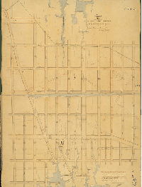
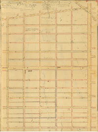
Plan of the Fourth Section of the Township of the Northern Liberties agreeably to an Act of the General Assembly of the Commonwealth of Pennsylvania passed the third day of May [AD] 1832. Surveyed and returned December 16, 1843 by John Foulkrod | Foulkrod, John | 1843 |
Mounted
45 x 62 in.
1 inch = c. 160 feet
|
Northern Liberties, 4th Section. Bounded by Front St. to Germantown Ave., Ontario to Juniata Sts., and Bristol Township line
Wingohocking Creek, old roads
|
| 068-01 HP |

|
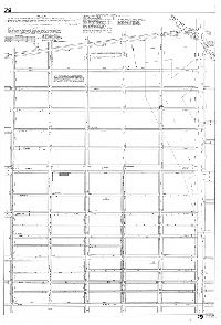
Plan of the survey [and regulation?] of the Western [Section?] of the Kensington District of the Northern Liberties. Approved by the Board of Commissioners February 1st, 1848. Arranged and revised by Benj. Moore. Confirmed by an Act of Assembly passed April 3rd A.D. 1848, with the provision that Sixth Street shall continue in the same range from its intersection with the Germantown Road northward. | Moore, Benjamin | 1848 |
Mounted
46 x 77 in.
1 inch = 100 feet
|
Kensington, Western Section. Bounded by Frankford Ave. to 6th St., Canal St. (Cohocksink Creek) to Morris (or Wood) St. above Diamond St.
Square at Frankford Road & Maiden St., hall at Masters and Front Sts.. Philadelphia and Trenton Railroad, Norris's Line, market shed at Washington St. between Jefferson and Masters Sts., sewers, curb heights, benchmark buildings
|
| 068-02 HP |
|
Plan of the Fourth Division of the survey and regulation (and part of the Third Division revised) of the Kensington District of the Northern Liberties. By Joseph H. Siddall May 2, 1836. Revised with the Supplementary Plan, March 5th, 1844. B. Moore | Siddall, Joseph H.; Moore, Benjamin | 1844 |
Mounted
45 x 33 in.
1 inch = 100 feet
|
Kensington District, 3rd and 4th Divisions. Bounded by Howard St. to 6th St., Jefferson St. to Diamond St.
Old street lines, sewer
|
| 068-03 HP |

|
Plan of the Third Division of the survey and regulation of the Kensington District of the Northern Liberties, agreeably to an Act of the General Assembly of the Commonwealth of Pennsylvania passed the sixth day of March anno Domini 1820. Surveyed and returned, March 21st, 1829, by Jos. H. Siddall. | Siddall, Joseph H. | 1829 |
Mounted
36 x 50 in.
1 inch = 50 feet
|
Kensington District, 3rd Division. Bounded by Front to Sixth Sts., Montgomery Ave. to Cohocksink Creek, Beaver St.
Cohocksink Creek (labeled Canal Street), benchmark buildings, curb elevations, sewers, block dimensions, mill pond and mill dam
|
| 068-03 HP tracing |

|
Plan of the Third Division of the survey and regulation of the Kensington District of the Northern Liberties, agreeably to an Act of the General Assembly of the Commonwealth of Pennsylvania passed the sixth day of March anno Domini 1820. Surveyed and returned, March 21st, 1829, by Jos. H. Siddall. | Siddall, Joseph H. | 1829 |
Tracing
36 x 52 in.
1 inch = 50 feet
|
Kensington District, 3rd Division. Front to Sixth, Montgomery to Cohocksink Creek, Beaver Street
Cohocksink Creek (labeled Canal Street), benchmark buildings, curb elevations, sewers, block dimensions, mill pond and mill dam
|
| 068-04 HP |

|
Plan of the Fourth Division of the survey and regulation of the Northern Liberties . . . Passed the 17th day of April [AD] 1795. Surveyed and returned March 3rd, 1819, per Rob. Brooke, J. Kessler. | Brooke, Robert; Kessler, J. | 1819 |
Mounted
25 x 31 in.
1 inch = 80 feet
|
Northern Liberties, 4th Division. Bounded by 2nd St. to 4th St. to Germantown Ave., Masters St. to Laurel St.
Cohocksink Creek / Canal; sewers and inlets, benchmark buildings, curb elevations
|
| 068-06a HP |

|
Supplement to the plan of the revision of the Third Division of the Kensington District. Returned March 5th, 1844. B. Moore. | Moore, Benjamin | 1844 |
Mounted
26 x 18 in.
1 inch = 100 feet
|
Kensington District, 3rd Division. Bounded by Masters St. to Montgomery Ave., West St. to Clinton St.
Sewers, curb elevations
|
| 068-06b HP |

|
Plan of the alteration of so much of the plans of the survey and regulation of the Third & Fourth Divisions of the Kensington District as related to the vacation of Columbia Avenue. Returned March 5th 1844. B. Moore. | Moore, Benjamin | 1844 |
Mounted
33 x 13 in.
1 inch = 100 feet
|
Kensington District, Columbia Avenue. Bounded by Clinton St. to 6th St., Oxford to Cherry St. (Montgomery Ave.)
Sewers, curb elevations, one benchmark building
|
| 068-07 HP |
|
Plan of the regulation of Hope Street between Canal and Otter Streets in the Sixteenth Ward of the City of Philadelphia | Siddall, Joseph H. | 1860 |
Mounted
22 x 10 in.
1 inch = c. 40 feet
|
Hope St.
Curb elevations
|
| 068-08 HP |

|
Plan of the Revision of the southerly part of the survey and regulation of the Third Division of the Kensington District. Draughted pursuant to the resolutions of the Board of Commissioners, July 7th,1835, by B. Moore. Revised and returned Oct. 1st, 1844 by B. Moore. | Moore, Benjamin | 1844 |
Mounted
26 x 38 in.
1 inch = 100 feet
|
Kensington District, 3rd Division (part). Bounded by Frankford Ave. to Apple St. (past 4th), Cohocksink Canal to (Thompson St.)
Sewers, curb elevations
|
| 069-01 HP |
|
Plan of Survey of that portion of the 27th Ward Philadelphia included in the Elmwood Land Association bounded by Tinicum Island Road, Hog Island Road, Church Creek and land of Mary A. Bonnaffon, made in accordance [Act of Assembly 31 Dec. 1886. All grades below City Datum] | Jones, William H. | 1887 |
Mounted
46 x 38 in.
1 inch = 100 feet
|
West Philadelphia, Bounded by Elmwood Ave., 85th to 90th Sts. Church Creek to Tinicum Ave.
Chester Branch, Philadelphia and Reading Railroad
|
| 069-01 HP tracing |
|
Plan showing natural elevations on the streets of the Elmwood Mutual Land Association, January 1889 | Not named | 1889 |
Tracing
30 x 32 in.
|
Southwest Philadelphia, Elmwood. Bounded roughly by Tinicum Ave. to Mingo Creek, 90th St. to 85th St.
Curb elevations (some are negative numbers), Mingoes (Mingo) Creek
|
| 069-z HP |

|
Plan of the common sewer or culvert as changed from Howard to Clinton Street between the Franklin Avenue and Oxford Street; and of the alteration in the levels and grade of the water-courses to suit the location of the culvert. June 2nd, 1846 by Benjamin Moore. | Moore, Benjamin | 1846 |
Mounted
14 x 27 in.
1 inch = 100 feet
|
Bounded by Franklin Ave. to beyond Oxford St., Howard to Hancock Sts.
Sewer, curb elevations
|
| 071-01 MTD |

|
Plan of the re-survey of a part of the Fourth Ward, Philadelphia, 1869 [Resolution March 24, 1866; survey returned June 1869; approved by Board of Surveyors Sept. 20, 1869; confirmed by Court May 15, 1871] | Shedaker, David Hudson | 1869 |
Mounted
17 x 36 in.
|
South Philadelphia. 4th Ward. Bounded by South to Fitzwater Sts., Fifth St. to Delaware River
Curb elevations, wharf outlines
|
| 071-02 MTD |

|
Plan showing the widening of Delaware Avenue from Dock St. to Washington Avenue [Act of Assembly May 15, 1871; ordinance May 13, 1872; confirmed June 24, 1872] | Daly, Thomas; Shedaker, David Hudson | 1872 |
Mounted
18 x 46 in.
|
Delaware Ave. and vicinity including Delaware River front, from Dock St. to Washington Ave.
Curb elevations, wharves and owners
|
| 071-03 MTD |

|
Plan showing revision of grades in the Second, Third and Fourth Wards, being part of Plan 99, authorised by Councils July 5th, 1877 | Not named | 1877 |
Mounted
41 x 56 in.
1 inch = 100 feet
|
South Philadelphia. Bounded by South St. to Wharton St., Delaware River to Passyunk Ave.
Curb elevations
|
| 071-z MTD |

|
Plan of Southwark, Moyamensing and Passyunk extending from the Delaware to the Schuylkill River and from South Street to the Canal, exhibiting the grades and watercourses in each district [Title from 199-z_HP, which is identical and more complete] | Kneass, Samuel H. | 1840 |
Mounted
27 x 93 in.
|
South Philadelphia. Delaware River to Schuylkill River, South St. to below Moore St. and line of Delaware and Schuylkill Canal (never built)
Curb elevations, wharves, This copy updated with current South Philadelphia City Plan numbers, and also includes text of Act of Assembly, June 21, 1839, authorizing the plan.
|
| 071-z MTD blueprint |
|
Plan of Southwark, Moyamensing and Passyunk extending from the Delaware to the Schuylkill River and from South Street to the Canal, exhibiting the grades and watercourses in each district | Kneass, Samuel H. | 1840 |
Blueprint
28 x 97 in.
1 inch = 300 feet
|
South Philadelphia. Bounded by Delaware River to Schuylkill River, South St. to the Canal south of Moore St.
Marine Asylum, U.S. Arsenal, Navy Yard, Moyamensing Prison, Canal, original and proposed curb elevations, river bank, wharves
|
| 072-03.5 MTD |

|
Plan of the survey and regulation of the Fourth Section of the Twenty-first Ward of the City of Philadelphia [Resolution, date not given; resurveyed June 10, 1861] | Keily, James | 1861 |
Mounted
53 x 41 in.
|
21st Ward, 4th Section. Bounded by Ridge Ave. to Schuylkill River, Green Lane to Shurs Lane
Streams, curb elevations, sewers, building footprints in pencil
|
| 072-24 MTD |

|
Plan of the revision of grades on Manayunk Avenue from Lyceum Ave. to Roxborough Avenue in the Twenty-first Ward, City of Philadelphia. [Ordinance April 3, 1888; survey returned June 16, 1888; confirmed Dec. 3, 1888] | Sundstrom, C. A. | 1888 |
Mounted
22 x 17 in.
|
Manayunk Avenue
Topography on portion of plan
|
| 072-33 MTD tracing |
|
Plan of revision of lines and grades of Plan No. 72, Twenty-first Ward Philadelphia. [Ordinance June 27, 1892; confirmed August 3, 1896] | Sundstrom, C. A. | 1896 |
Tracing
55 x 36 in.
|
Manayunk. Bounded by Ridge Ave. to Schuylkill River, Green Lane to Shurs Lane
Building footprints, Manayunk Canal, Schuylkill River
|
| 073-a HP |
|
Delaware River between Bridesburg and Petty's Island. Topography by R. M. Bache, Assistant, C. Acton Ives, Aid. Neville B. Craig, Draughtsman, 1878. U.S. Coast and Geodetic Survey, Carlile P. Patterson, Superintendent | Bache, R. M. | 1878 |
Mounted
32 x 52 in.
1 inch = 400 feet
|
Delaware River front
Topography, soundings, riverfront buildings and industry, railroads, wharves, marshland, creeks, drainage ditches, river bank
|
| 073-b HP |

|
Delaware River between Richmond Coal Wharves and Kaighn's Point. Topography by R. M. Bache, Assistant. W. A. Pratt and Neville B. Craig, Foremen 1879. U.S. Coast and Geodetic Survey, Carlile P. Patterson, Superintendent | Bache, R. M. | 1879 |
Mounted
52 x 32 in.
1 inch = 400 feet
|
Delaware River front, Pennsylvania and New Jersey sides
Topography, soundings, marshland, wharves, railroads, Petty's Island, Smith and Windmill Islands, riverfront industry, ferry routes, tributary streams, and many other features
|
| 073-c HP |
|
Delaware River between Kaighn's Point and League Island. Topography by R. M. Bache, Assistant, W. A. Pratt, Foreman, 1879. U.S. Coast and Geodetic Survey, Carlile P. Patterson, Superintendent | Bache, R. M. | 1879 |
Mounted
32 x 52 in.
1 inch = 400 feet
|
Delaware River front, Pennsylvania and New Jersey sides
Topography, soundings, riverfront buildings and industry, railroads, wharves, marshland, creeks, drainage ditches, river bank
|
| 073-d HP |
|
Delaware River between League Island and Red Bank. Topography by R. M. Bache, Assistant, C. McKibbin Craig, Foreman, 1878. U.S. Coast and Geodetic Survey, Carlile P. Patterson, Superintendent | Bache, R. M. | 1878 |
Mounted
32 x 52 in.
1 inch = 400 feet
|
Delaware River front
Topography, soundings, riverfront buildings and industry, railroads, wharves, marshland, creeks, drainage ditches, river bank, League Island, U.S. Navy Yard, Fort Mifflin
|
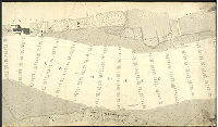
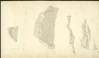
| 073-u HP |

|
[No title. Delaware River front, New Jersey and Pennsylvania sides of river, with soundings and detailed delineation of topography, vegetation and structures.073-u, v, w and x are contiguous and cover from Bridesburg to Poquessing Creek; 073-y_HP shows detailed drawings of riverfront locations. These hand-drawn plans were used as the basis of subsequent USCGS lithographs of the city waterfront.] | Craig, Neville B. | 1885 |
Mounted
30 x 52 in.
1 inch = 200 feet
|
Delaware River front, Pennsylvania and New Jersey sides
Riverfront properties, marshland, woodland, farmland, creeks, soundings
|
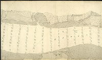
| 073-v HP |
|
[No title. Delaware River front, New Jersey and Pennsylvania sides of river, with soundings and detailed delineation of topography, vegetation and structures.073-u, v, w and x are contiguous and cover from Bridesburg to Poquessing Creek; 073-y_HP shows detailed drawings of riverfront locations. These hand-drawn plans were used as the basis of subsequent USCGS lithographs of the city waterfront.] | Craig, Neville B. | 1885 |
Mounted
30 x 52 in.
1 inch = 200 feet
|
Delaware River front, Pennsylvania and New Jersey sides
Riverfront properties, marshland, woodland, farmland, creeks, soundings
|
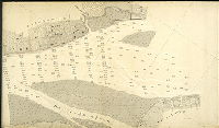
| 073-w HP |
|
[No title. Delaware River front, New Jersey and Pennsylvania sides of river, with soundings and detailed delineation of topography, vegetation and structures.073-u, v, w and x are contiguous and cover from Bridesburg to Poquessing Creek; 073-y_HP shows detailed drawings of riverfront locations. These hand-drawn plans were used as the basis of subsequent USCGS lithographs of the city waterfront.] | Craig, Neville B. | 1885 |
Mounted
30 x 52 in.
1 inch = 200 feet
|
Delaware River front, Pennsylvania and New Jersey sides
Riverfront properties, marshland, woodland, farmland, creeks, soundings
|
| 073-x HP |
|
[No title. Delaware River front, New Jersey and Pennsylvania sides of river, with soundings and detailed delineation of topography, vegetation and structures.073-u, v, w and x are contiguous and cover from Bridesburg to Poquessing Creek; 073-y_HP shows detailed drawings of riverfront locations. These hand-drawn plans were used as the basis of subsequent USCGS lithographs of the city waterfront.] | Craig, Neville B. | 1885 |
Mounted
30 x 52 in.
1 inch = 200 feet
|
Delaware River front, Pennsylvania and New Jersey sides
Riverfront properties, marshland, woodland, farmland, creeks, soundings,
|
| 073-y HP |
|
[No title. Delaware River front, New Jersey and Pennsylvania sides of river, with soundings and detailed delineation of topography, vegetation and structures.073-u, v, w and x are contiguous and cover from Bridesburg to Poquessing Creek; 073-y_HP shows detailed drawings of riverfront locations. These hand-drawn plans were used as the basis of subsequent USCGS lithographs of the city waterfront.] | Craig, Neville B. | 1885 |
Mounted
52 x 30 in.
1 inch = 200 feet
|
Delaware River front, Pennsylvania and New Jersey sides. Details of riverfront.
Riverfront properties, marshland, woodland, farmland, creeks, soundings,
|
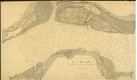
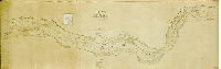
| 073-z HP |
|
Chart of the Delaware River in front of the City of Philadelphia from Bridesburg to Fort Mifflin. | USCGS | 1879 |
Mounted
28 x 82 in.
1 inch = 800 feet
|
Delaware River and adjacent land in Pennsylvania and New Jersey, from Fort Mifflin to Bridesburg
Topography, soundings, navigation channels, marshland, river banks, islands, wharves, creeks
|
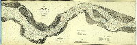
| 074-01 HP |
|
Plan of a survey of the River Delaware from one mile below Chester to Richmond above Philadelphia, taken by order of Councils in the months of July, August & September Anno Domini 1819 by David McClure. | McClure, David | 1820 |
Mounted
39 x 121 in.
1 inch = 832 feet; 6.4 inches to the mile; 1:9900
|
Delaware River front, from one mile below Chester to Richmond above Philadelphia
Topography, soundings, bars, islands, natural and artificial river banks, ship and sloop channels, water grass, water-dock (or splatter-dock, now called spatter-dock), mud, sand, two shipwrecks, and various landmarks on both the Pennsylvania and New Jersey shorelines; "Coloured by Joseph H. Siddall, Draughtsman, 1820"
|
| 075-01 HP |

|
[No title. Probably part of the incorporation of the District of Spring Garden, from the unincorporated Northern Liberties. Note on tracing copy of plan: "See Laws A.D. filed 8th April 1816."] | Brooke, Robert; Kessler, J. | 1816 |
Mounted
47 x 33 in.
1 inch = 100 feet
|
Spring Garden District, Vine St. to Hickory Lane (Fairmount Ave.), 6th to Broad Sts.
Street lines, benchmarks
|
| 075-01 HP tracing |

|
[No title. Probably part of the incorporation of the District of Spring Garden, from the unincorporated Northern Liberties. Note on tracing copy of plan: "See Laws A.D. filed 8th April 1816."] | Brooke, Robert; Kessler, J. | 1816 |
Tracing
47 x 36 in.
1 inch = 100 feet
|
Spring Garden District, bounded by Vine St. to Hickory Lane (Fairmount Ave.), 6th to Broad Sts.
Street lines, benchmarks
|
| 075-02 HP |

|
Draught or plan of the First Section of the survey of the District of Spring Garden, made in pursuance of an Act of the Legislature of Pennsylvania | Brooke, Robert; Kessler, J. | 1818 |
Mounted
27 x 22 in.
1 inch = 100 feet
|
Spring Garden District, 1st Section. Bounded by Vine St to Hickory Lane (Fairmount), 6th to Lawrence
Pegg's Run /Willow St., property owners, building footprints in street lines
|
| 076-01 HP |

|
Plan of the survey and regulation of the ascents descents common sewers and distances of the gutters from the sides of the Streets lanes &c in the neighbourhood of the site upon which the State Penitentiary for the Eastern District is about to be erected, in Penn Township in the County of Philadelphia, agreeably to an Act of the General Assembly of the Commonwealth of Pennsylvania, passed the second day of February, One thousand eight hundred and twenty-two. Surveyed and returned April 13th 1822 by Samuel Hains, Recording Surveyor, Jos. H. Siddall, Regulator of Spring Garden. | Hains, Samuel; Siddall, Joseph H. | 1822 |
Mounted
24 x 36 in.
1 inch = 100 feet
|
Penn Township. Bounded by Callowhill St. to north of Coates St., 20th to 24th Sts.
Streams, inlets, sewers, curb elevations
|
| 076-02 HP |

|
Plan of the survey and regulation of the ascents, descents, common sewers &c in the neighbourhood of the new State Penitentiary for the Eastern District. Altered from the former regulation pursuant to an Act of the General Assembly of the Commonwealth of Pennsylvania, passed the April 28th A.D. 1829, by P. M. Price. [Approved 1830] | Price, Philip M. | 1830 |
Mounted
36 x 24 in.
1 inch = 100 feet
|
Penn Township, vicinity of Eastern State Penitentiary.
State Penitentiary, sewer and inlets, curb elevations
|
| 077-01 HP |

|
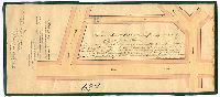
Draft of a State Road leading from the Borough of Media in the County of Delaware to Lancaster Avenue in the City of Philadelphia, surveyed for the commissioners June and July 1870 by Benj. H. Smith surveyor. | Smith, Benjamin H. | 1870 |
Mounted
10 x 109 in.
1 inch = 30 perches; inset: 1 inch = 100 feet
|
State Road from 53rd St. and Lancaster Ave., Philadelphia, to Media, Delaware County
Philadelphia Orphan Asylum, Springfield Meeting House, many named streams, property owners, topographical shading, building footprints, milestones, inset showing Lansdowne Ave. from Lancaster Ave. to 54th St.
|
| 079-01 HP |
|
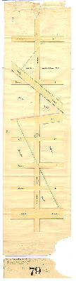
Draught of the survey and regulation of the ascents and descents, common sewers, gutters, &c. in Francis Lane & Coats Street, from Broad Street to Schuylkill Third [Twentieth] St. and from William Street to the River Schuylkill in the District of Spring Garden. Made by virtue of an order of the Court of Quarter Sessions, dated January 27th 1827, agreeably to an Act of the Genl. Assembly of the Commonwealth of Pennsylvania, passed the second day of February 1822. Surveyed and returned May 29th 1827 by Samuel Hains, Jos. H. Siddall | Hains, Samuel; Siddall, Joseph. H. | 1827 |
Mounted
13 x 75 in.
1 inch = 100 feet
|
Spring Garden District, Francis Lane & Coats St., Broad to 20th Sts., William St. to Schuylkill River.
Store by Schuylkill; two sewer inlets for small streams
|
| 079-02 HP |
|
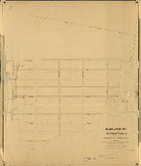
Plan of the Fifth Division of the survey and regulation of the District of Spring Garden, agreeably to an Act of the General Assembly of the Commonwealth of Pennsylvania passed the 22nd day of March anno Domini 1813 – and a supplement thereto passed the 2nd day of March anno Domini 1827. Surveyed and returned Jany. 31st A.D. 1828 by P. M. Price. [Attachment: Court certification, 1831] | Price, Philip M. | 1828 |
Mounted
52 x 38 in.
1 inch = 80 feet
|
Spring Garden District, 5th Division. Bounded by Vine St. to Fairmount Ave., Broad to 19th Sts.
Building footprints for some benchmarks with some property owners, sewers, inlets
|
| 079-02 HP attachment |

|
[Court confirmation of plan 079-2_HP] | Not named | 1831 |
Paper
|
Spring Garden District, 5th Division. Bounded by Vine St. to Fairmount Ave., Broad to 19th Sts.
Attachment
|
| 079-02 HP tracing |
|
Plan of the Fifth Division of the survey and regulation of the District of Spring Garden, agreeably to an Act of the General Assembly of the Commonwealth of Pennsylvania passed the 22nd day of March anno Domini 1813 – and a supplement thereto passed the 2nd day of March anno Domini 1827. Surveyed and returned Jany. 31st A.D. 1828 by P. M. Price. [Attachment: Court certification, 1831] | Price, Philip M. | 1828 |
Tracing
56 x 38 in.
|
Spring Garden District, 5th Division. Bounded by Vine St. to Fairmount Ave., Broad to 19th Sts.
Building footprints for benchmarks, property owners, sewers, inlets
|
| 079-x2 HP |
|
Plan of Schuylkill 8th Street [from Parrish to Morris] . . . Filed 18 June 1841. [Attachment: Court confirmation of plan] | Siddall, Joseph H., probably | 1841 |
Paper
34 x 9 in.
1 inch = 100 feet
|
South Philadelphia. 15th Street, from Parrish to Morris Sts.
Building footprint in street, property owners
|
| 080-01 HP |

|
Plan of Union Canal. [Plan] purchased by City of Philadelphia at sale of E. D. Roberts. Samuel S. Smedley, Chief Engineer and Surveyor, October 9, 1889. | Lightfoot, Francis | 1842 ca. |
Mounted
30 x 31 in.
|
Union Canal (Pennyslvania Ave., Reading Railroad). 21st to 25th Sts., Callowhill St. to Fairmount Ave.
Building footprints in path of Canal
|
| 080-02 HP |
|
Plan of the regulation of ascents & descents of Callowhill Street, from the east side of Broad Street to the Lancaster & Schuylkill Bridge. Made agreeably to an Act of the General Assembly of the Commonwealth of Pennsylvania passed the sixteenth day of March anno Domini One thousand eight hundred and twenty. Surveyed and returned May 1st, 1820 by Rob. Brooke, Samuel Hains. | Brooke, Robert; Hains, Samuel | 1820 |
Mounted
26 x 72 in.
1 inch = 100 feet
|
Callowhill Street, from Broad Street to the Lancaster & Schuylkill Bridge (near line of present Spring Garden St.)
Lancaster and Schuylkill Bridge, swampy areas leading into small streams, curb elevations
|
| 080-03 HP |
|
[No title. “Surveyed and returned September 2nd 1833 by Joseph Fox, Philip M. Price] | Fox, Joseph; Price, Philip M. | 1833 |
Mounted
25 x 64 in.
|
Spring Garden. Bounded by 6th to 25th Sts., Vine St. to Fairmount Ave.
Willow Street (Pegg's Run), curb elevations, sewers and inlets
|
| 080-05 HP |

|
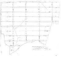
Plan of the Sixth Division of the survey and regulation of the District of Spring Garden, agreeably to an Act of the General Assembly of the Commonwealth of Pennsylvania passed March 22nd anno Domini 1822; and a supplement thereto passed March 2nd A.D. 1827. Surveyed and returned July 23rd 1830 by P. M. Price | Price, Philip M. | 1830 |
Mounted
40 x 39 in.
1 inch = 80 feet
|
Spring Garden District, 6th Division. Bounded by 19th to 25th Sts., Vine St. to Fairmount Ave.
Buildings in streets, sewers, curb elevations, wharves
|