
Philadelphia Streets Department Surveys
2755 result(s). Showing results 301 to 350.
View page: 1 2 3 4 5 6 7 8 9 10 11 12 13 14 15 16 17 18 19 20 21 22 23 24 25 26 27 28 29 30 31 32 33 34 35 36 37 38 39 40 41 42 43 44 45 46 47 48 49 50 51 52 53 54 55 56 (Show all on one page)
| Identifer | Preview | Title | Surveyor | Date | Media / Size / Scale | Area / Map Features |
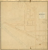
| 081-01 HP |
|
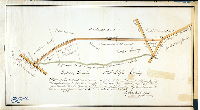
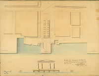
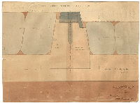
Plan of the proposed widening of Callowhill Street and 25th street as approaches to Fairmount Park and the Wire Bridge, Philadelphia, Oct. 3rd, 1870, Edw. D. Roberts. | Roberts, Edward D. | 1870 |
Mounted
45 x 44 in.
1 inch = 50 feet
|
Fairmount Park, approaches, Callowhill St. and 25th St Powelton Ave. (Callowhill St.) to Pennsylvania Ave., 23rd St. to Schuylkill River.
Fairmount Water Works Reservoir, landscaped park entry at Green St., property lines encroaching on 25th St. and Callowhill
|
| 081-02 HP |
|
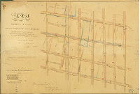
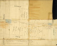
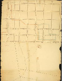
Plan of the Seventh Division of the survey and regulation of the District of Spring Garden, agreeably to an Act of the General Assembly of the Commonwealth of Pennsylvania passed the Twenty-second day of March Anno Domini 1815, and a supplement thereto passed the Second day of March Anno Domini 1827. Surveyed and returned Dec. 24th 1828 by P. M. Price | Price, Philip M. | 1828 |
Mounted
33 x 25 in.
1 inch = c. 80 feet
|
Spring Garden District, 7th Division. Bounded by Hamilton St. to Fairmount Ave, 24th St. to Schuylkill River
Fairmount Water Works, covered bridge, vacated streets, benchmark buildings. Lancaster and Schuylkill Bridge, common sewers leading into river
|
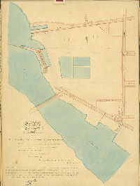
| 081-03 HP |
|
Map of the Fair-Mount Water Works and of the eastern termination of the Philadelphia and Columbia Rail Road. Childs & Inman, lithographers, F. Graff del. | Graff, Frederick, Sr. | 1830 ca. |
Lithograph
21 x 29 in.
1 inch = 200 feet
|
Spring Garden District, Fairmount Water Works and vicinity, 20th St. to Schuylkill River, Vine St. to north of Fairmount Ave.
Fairmount Waterworks, Pagoda, Pratt's (Lemon Hill), hotel, line of Union Canal, elevation of Fairmount Waterworks and reservoirs and pipelines from it, streams, topography
|
| 081-04 HP |
|
[No title. Vine St. to Spring Garden St., 22nd St. to the Schuylkill River. Perhaps part of the 7th Division of the survey and regulation of Spring Garden. See plan 081-02_HP.] | Price, Phillip M. (probably) | 1830 ca. |
Mounted
22 x 29 in.
1 inch = c. 80 feet
|
Spring Garden District, Vine to Spring Garden Sts., 22nd St. to Schuylkill River
Bridge Street, sewers, wetlands, curb elevations, tidal soundings
|
| 082-01 HP |
|
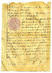
Plan of the Eighth Division of the survey and regulation of the District of Spring Garden, agreeably to an Act of the General Assembly of the Commonwealth of Pennsylvania passed the 22nd day of March A.D. 1813; and a supplement thereto passed the 2nd day of March A.D. 1827. Surveyed and returned June 10th 1831 by Philip M. Price, Joseph Fox. [Attachment: Quarter Sessions Court confirmation certificate] | Price, Philip M.; Fox, Joseph | 1831 |
Mounted
26 x 38 in.
1.25 inch = 100 feet
|
Spring Garden District, 8th Division. Bounded by Coates St. (Fairmount Ave.) to Poplar St., 6th to 10th Sts.
Sewers, property owners, benchmark buildings, buildings in street lines
|
| 082-01 HP attachment |
|
[Court confirmation of plan 082-01_HP] | Not named | 1834 |
Paper
|
Spring Garden District, 8th Division. Bounded by Coates St. (Fairmount Ave.) to Poplar St., 6th to 10th Sts.
Attachment
|
| 082-02 HP |
|
Plan of the Eighth Division of the survey and regulation of the District of Spring Garden, agreeably to an Act of the General Assembly of the Commonwealth of Pennsylvania passed the 22nd day of March anno Domini [1813]; and a supplement thereto passed the 2nd day of March A.D. [1827]. Surveyed and returned June 10th A.D. 1831 by Philip M. Price, Joseph Fox, R. M. Sexton draughtsman. | Price, Philip M.; Fox, Joseph | 1831 |
Mounted
26 x 38 in.
1.25 inch = 100 feet
|
Spring Garden District, 8th Division. Bounded by Coates St. (Fairmount Ave.) to Poplar St., 6th to 10th Sts.
Sewers, property owners, benchmark buildings, buildings in street lines
|
| 083-01 HP |
|
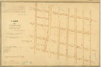
Plan of the Ninth Division of the survey and regulation of the District of Spring Garden, agreeably to an Act of the General Assembly of the Commonwealth of Pennsylvania passed the twenty second day of March anno Domini One thousand eight hundred and thirteen -- and a supplement thereto passed second day of March anno Domini One thousand eight hundred and twenty seven. Surveyed and returned June 10th 1831 by Philip M. Price, Joseph Fox | Price, Philip M.; Fox, Joseph; R.M. Sexton, draughtsman | 1831 |
Mounted
26 x 40 in.
1.25 inch = 100 feet
|
Spring Garden District, 9th Division. Bounded by 10th St. to Broad St., Coates St. (Fairmount Ave.) to Poplar St.
Sewers, property owners, benchmark buildings
|
| 083-02 HP |
|
Plan of the Ninth Division of the survey and regulation of the District of Spring Garden, agreeably to an Act of the General Assembly of the Commonwealth of Pennsylvania passed the 22nd day of March A.D. 1813; and a supplement thereto passed the 2nd day of March A.D. 1827. Surveyed and returned June 10th A.D. 1831 by Philip M. Price, Joseph Fox. [Attachment: Quarter Session Court confirmation certificate] | Price, Philip M.; Fox, Joseph | 1831 |
Mounted
26 x 39 in.
1.25 inch = 100 feet
|
Spring Garden District, 9th Division. Bounded by 10th St. to Broad St., Coates St. (Fairmount Ave.) to Poplar St.
Sewers, property owners, benchmark buildings
|
| 083-02 HP attachment |
|
[Court confirmation of plan 083-02_HP] | 1831 |
Paper
|
Spring Garden District, 9th Division. Bounded by 10th St. to Broad St., Coates St. (Fairmount Ave.) to Poplar St.
Attachment
|
|
| 084-01 HP |
|
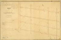
Plan of the Tenth Division of the survey and regulation of the District of Spring Garden, agreeably to an Act of the General Assembly of the Commonwealth of Pennsylvania passed the twenty second day of March anno Domini One thousand eight hundred and thirteen, and a supplement thereto passed the second day of March anno Domini One thousand eight hundred and twenty seven. Surveyed and returned March 3rd 1834 by Joseph Fox, Philip M. Price. R. M. Sexton draughtsman | Fox, Joseph; Price, Philip M. | 1834 |
Mounted
26 x 40 in.
1.25 inch = 100 feet
|
Spring Garden District, 10th Division. Bounded by Broad to Schuylkill 4th (19th) St., Coats (Coates) St. (now Fairmount Ave.) to Poplar St.
House of Refuge, Burial Ground, property owners, buildings in street lines, sewers, benchmark buildings
|
| 084-02 HP |
|
Plan of the Tenth Division of the survey and regulation of the District of Spring Garden, agreeably to an Act of the General Assembly of the Commonwealth of Pennsylvania passed the 22nd day of March A.D. 1813 and a supplement thereto passed the 2nd day of March A.D. 1827. Surveyed and returned March 3rd 1834 by Joseph Fox, Philip M. Price. [Attachment: Quarter Sessions Court confirmation certificate] | Fox, Joseph; Price, Philip M. | 1834 |
Mounted
26 x 38 in.
1.25 inch = 100 feet
|
Spring Garden District, 10th Division. Bounded by Broad to Schuylkill 4th (19th) St., Coats (Coates) St. (now Fairmount Ave.) to Poplar St.
House of Refuge, Burial Ground, property owners, buildings in street lines, sewers, benchmark buildings
|
| 084-02 HP attachment |
|
[Court confirmation of plan 084-02_HP] | Not named | 1834 |
Paper
|
Spring Garden District, 10th Division. Bounded by Broad to Schuylkill 4th (19th) St., Coats (Coates) St. (now Fairmount Ave.) to Poplar St.
Attachment
|
| 085-01 HP |
|
Plan of the Eleventh Division of the survey and regulation of the District of Spring Garden, agreeably to an Act of the General Assembly of the Commonwealth of Pennsylvania passed the twenty second day of March anno Domini One thousand eight hundred and thirteen, and a supplement thereto passed the second day of March A.D. One thousand eight hundred and twenty seven. Surveyed and returned Nov. 22nd 1834 by Joseph Fox, Philip M. Price. [Attachment: Quarter Sessions Court confirmation certificate] | Fox, Joseph; Price, Philip M. | 1834 |
Mounted
29 x 43 in.
1.25 inch = 100 feet
|
Spring Garden District 11th Division. Bounded by Schuylkill 4th (19th) St., to Williams (24th) St., Coates St. (Fairmount Ave.) to Poplar St.
Burial ground, Eastern State Penitentiary, Board of Health property, property owners, sewers, benchmark buildings
|
| 085-01 HP attachment |
|
[Court confirmation of Plan 085-01_HP] | Not named | 1836 |
Paper
|
Spring Garden District 11th Division. Bounded by Schuylkill 4th (19th) St., to Williams (24th) St., Coates St. (Fairmount Ave.) to Poplar St.
Attachment
|
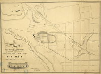
| 086-01 HP |
|
Plan of the Twelfth Division of the survey and regulation of the District of Spring Garden, agreeably to an Act of the General Assembly of the Commonwealth of Pennsylvania passed the twenty second day of March A.D. One thousand eight hundred and thirteen -- and a supplement thereto passed the second day of March anno Domini One thousand eight hundred and twenty seven. Surveyed and returned June 24th 1834 by Joseph Fox, Philip M. Price, R. M. Sexton draughtsman. [Attachment: detail plan showing railroad at Minor St.] | Fox, Joseph; Price, Philip M.; R.M. Sexton, draughtsman | 1834 |
Mounted
33 x 47 in.
1.25 inch = 100 feet
|
Spring Garden District, 12th Division. Bounded by William (24th) St. to Landing Ave. (29th St.), Coates St. (Fairmount Ave.) to Poplar St.
Public Landing, sewers, property owners, benchmark buildings
|
| 086-01 HP attachment |
|
[No title. Plan showing Pennsylvania Railroad between Minor St. and Bush Hill St. Plan also shows "Canal Ground"] | Fox, Joseph | 1851 |
Paper
8 x 10 in.
|
Bounded by Bush Hill St., "Canal Ground", Minor St., and unnamed street at top of plan
Attachment: Railroad, canal ground. "Survey & plan $6.00 paid"
|
| 086-02 HP |
|
Plan of the Twelfth Division of the survey and regulation of the District of Spring Garden, agreeably to an Act of the General Assembly of the Commonwealth of Pennsylvania passed the twenty second day of March anno Domini One thousand eight hundred and thirteen, and a supplement thereto passed the second day of March A.D. One thousand eight hundred and twenty seven. Surveyed and returned June 24th 1834 by Joseph Fox, Philip M. Price. [Attachment: Quarter Session Court confirmation certificate] | Fox, Joseph; Price, Philip M. | 1834 |
Mounted
32 x 50 in.
1.25 inch = 100 feet
|
Spring Garden District, 12th Division. Bounded by William (24th) St. to Landing Ave. (29th St.), Coates St. (Fairmount Ave.) to Poplar St.
Public Landing, sewers, property owners, benchmark buildings
|
| 086-02 HP attachment |
|
[Court confirmation of Plan 086-02_HP] | Not named | 1834 |
Paper
|
Spring Garden District, 12th Division. Bounded by William (24th) St. to Landing Ave. (29th St.), Coates St. (Fairmount Ave.) to Poplar St.
Attachment
|
| 086-03 HP |
|
[No title. Docks on the Schuylkill River, north of Coates St. above the Fairmount Water Works] | Not named | 1830 ca. |
Paper
14 x 22 in.
1.25 inch =100 feet
|
Spring Garden District. Bounded by Schuylkill River to railroad, Coates St. (Fairmount Ave.) to unnamed street to north
Railroad, public landing, property owners, names on plan: "Samson, John; Pearson, Joseph; W.B."
|
| 086-04 HP |
|
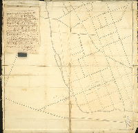
Plan of the District of Spring Garden in the County of Philadelphia. | Not named | 1850 ca. |
Mounted
26 x 65 in.
1 inch = 200 feet
|
Spring Garden District. Bounded by Poplar St. to Vine St., Schuylkill River to 6th St.
Lemon Hill, Fairmount Water Works, Eastern State Penitentiary, wharves
|
| 086-x1 HP |
|
Plan of ground appropriated for the preservation for the purity of water and in addition to Fairmount Park under ordinance of the City of Philadelphia, approved June 28th, 1864. | Roberts, Edward D. | 1864 |
Tracing
42 x 59 in.
1 inch = 25 feet
|
Spring Garden District. Bounded by Schuylkill River to 26th St., Hare St. to Coates St. (Fairmount Ave.)
Business names on building footprints, property owners
|
| 087-01 HP |
|
Map of the River Schuylkill from Fairmount to South St. exhibiting the revised wharf lines established by authority of Act of Assembly, April 9, 1867, and resolution of Councils, June 1, 1867 | Shedaker, David Hudson; Roberts, Edward D.; Smedley, Samuel L.; Miller, James | 1869 |
Mounted
31 x 74 in.
1 inch = 100 feet
|
Schuylkill River from Spring Garden St. to South St.
Gas works, river banks, Almshouse, property owners along river
|
| 087-02 HP |
|
Plan for wharves along the Port Warden's line in front of property of the Pennsylvania Rail-Road Company on the west side of the River Schuylkill in the 24th Ward Philadelphia. | Smedley, Samuel L. | 1860 |
Mounted
27 x 43 in.
1 inch = 60 feet
|
West Philadelphia, Schuylkill River front. Bounded by Market to Race Sts., river to 30th St.
Market St. Bridge, Port Wardens Line, wharf
|
| 087-03 HP |
|
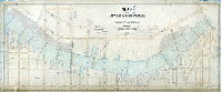
Plan of the First Section of the survey of the River Schuylkill exhibiting the position of the wharves now constructed with the soundings of the river, and showing the wharf lines as established in pursuance of an Act of Assembly approved the 6th day of April A.D. 1850 [Survey returned April 5, 1851] | Roberts, Edward D.; Kneass, Samuel H.; Daly, Thos.; Miller, James | 1851 |
Mounted
26 x 78 in.
1 inch = 100 feet
|
Schuylkill River, from Fairmount Dam to Cedar (now South) St.
Beaver Run, Pennsylvania Railroad Co.'s land, Fairmount Reservoir, South Garden of Water Works, wharves, railroad, marshland, some property owners, embankments, river soundings
|
| 087-04 HP |

|
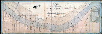
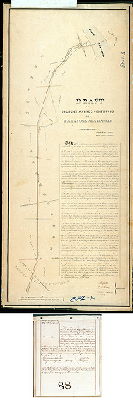
Draught of a survey from Fair-mount, to the mouth of Schuylkill, by order of the Councils | McClure, David | 1828 |
Mounted
23 x 100 in.
1 inch = 412 feet (12.8 inches = 1 mile)
|
Schuylkill River from below Fairmount Dam to the river's mouth.
Naval Asylum, arsenal, Dr. Say's, Dupuy's rock, Bartram's Botanic Garden Fish Cabin, Hamburg Tavern, Girard Point, Old Lazaretto, [Schuylkill] canal, Harding's Tavern, Hamilton's, Mill Creek, woolen factory, river soundings, natural and artificial river banks
|
| 087-y HP |
|
[No title. Ridgway Estate and other properties in the vicinity of 24th Street and Callowhill Street, as crossed by the Schuylkill River East Side Railroad]. | Roberts, Edward D. | 1888 |
Tracing
20 x 26 in.
|
Spring Garden. Vicinity of 24th and Callowhill
Schuylkill River East Side Railroad
|
| 087-z HP |
|
Plan showing Wood Street from 24th St. to Schuylkill River as proposed to be placed on the City Plan. | Bloch, Frits | 1896 |
Tracing
25 x 23 in.
1 inch = 30 feet
|
Spring Garden. Wood Street, vicinity of 24th and Callowhill Sts.
Schuylkill River East Side Railroad
|
| 088-01 HP |
|
Draft of Belmont Avenue continued or Manayunk State-Road [Attachment: Certificate recording swearing in of three road commissioners, Joseph Fox, Paul Jones and Algernon Roberts] | Fox, Charles H. | 1854 |
Mounted
42 x 18 in.
1 inch = c. 200 feet
|
Belmont Ave. from Schuylkill River to Ford Rd. (Lower Merion Twp.)
Reading Railroad, Manayunk Bridge, property owners, one building; Samuel L. Smedley, draftsman
|
| 088-02 HP |
|
Plan of a State Road laid out from or near the Blacksmith shop in Mechanicsville in Byberry Township Philadelphia County to the Public road leading from Byberry Meeting House to Dunk’s ferry near Joseph P. Knight’s Gate in Bensalem Township Bucks County in pursuance of an Act of the General Assembly of Pennsylvania passed the 24th day of June AD 1839. Surveyed September 5th 1839 by John Foulkrod Sur. | Foulkrod, John | 1839 |
Mounted
12 x 22 in.
1 inch = 200 feet
|
Byberry Twp. and Bucks County, now Century Lane at crossing of Poquessing Creek
Poquessing Creek, property ownership, building footprints
|
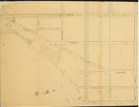
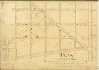
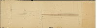
| 089-04 HP |
|
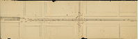
Plan showing the revision of the footways and grades on Broad Street | Close, Charles S. | 1875 |
Mounted
61 x 14 in.
|
Broad Street. South Philadelphia
Curb elevations
|
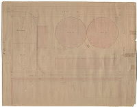
| 089-10 HP |
|
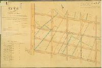
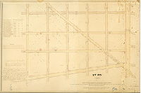
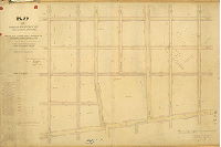
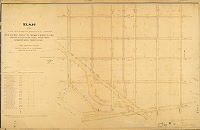
Plan 89 [Full title from original mounted plan: "Plan of the survey of regulation of the Ninth Section, Twenty-sixth Ward, Philadelphia by Charles S. Close, Surveyor & Regulator, Second District] [Resolutions March 24, 1866 and March 11, 1877; approved by Board of Surveyors Sept. 19, 1881] | Close, Charles S. | 1881 |
Tracing
45 x 38 in.
1 inch = 100 feet
|
South Philadelphia, 26th Ward, 9th Section. Broad to 8th Sts., Ellsworth to McKean Sts.
Curb elevations
|
| 089-z HP |
|
Plan for placing Titan Street from Watts Street westward to dead end on City Plan No. 89, Twenty-sixth Ward | Puff, Charles F. Jr. | 1900 ca. |
Paper
|
South Philadelphia. Titan Street
Curb elevations
|
| 090-01 HP |
|
East View of the City Wharf and Fish Market. This is the plan referred to in the report of the Committee on Markets for the improvement of High Street Wharf & Fish Market House. Nov. 12, 1829. N. R. Potts –– Clerk of Common Council. | Graff, Frederick, Sr. (probably) | 1829 |
Paper
19 x 25 in.
1 inch = 25 feet
|
Philadelphia. Market St. at Delaware River
Beck's Wharf, City Wharf, Girard's Wharf, Fish Market, sewers, elevation view of buildings
|
| 090-02 HP |
|
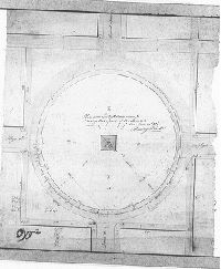
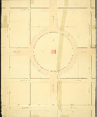
Plan and Calculations made for Curbing the S. part of the [Centre] Square with a Circle here represented done in 1808. Reading Howell | Howell, Reading | 1808 |
Microfilm Only
|
Curbing the S. part of the [Centre] Square with a Circle here represented done in 1808.
|
| 090-q HP |
|
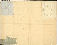
[No title. Plan showing railroad line curving from High Street into Broad Street.] | Not named | 1850 ca. |
Paper
11 x 25 in.
|
Philadelphia, Railroad
Railroad
|
| 090-r HP |
|
[No title. Railroad intersection at Broad and High Streets. Two attached working drawings.] | Not named | 1850 ca. |
Paper
24 x 34 in.
|
Philadelphia, Railroad
Railroad
|
| 090-s HP part1 |
|
[No title. Railroad on Market Street from Juniper St. to Schuylkill 8th St. Shows arrangement of tracks and intersection of Broad and High (Market) Streets. See 90-s_HP_part 2 for adjoining plan.] | Not named | 1850 ca. |
Paper
20 X 74 in.
|
Philadelphia. Railroad, Market Street from Juniper Street to Schuylkill 8th (now 15th)
Railroad, market house
|
| 090-s HP part2 |
|
[No title. Railroad on Market Street from Schuylkill 5th to Schuylkill 7th Sts. (16th to 19th Sts.) See 90-s_HP_part 1 for adjoining plan.] | Not named | 1850 ca. |
Paper
20 X 69 in.
|
Philadelphia. Railroad, Market Street from Schuylkill 5th (now 18th) to Schuylkill Seventh (now 16th)
Railroad, market house
|
| 090-t HP |
|
Schuylkill Railway, Beech St., High (Market) to Chestnut St. | Hains, Samuel (probably) | 1850 ca. |
Paper
20 x 26 in.
|
Philadelphia. Railroad. Bounded by High (Market) St., Ashton St., Chestnut St. and Beech St. (Near Schuylkill River)
Railroad, gas works
|
| 090-u HP |
|
City Rail | Not named | 1850 ca. |
Paper
23 x 19 in.
|
Philadelphia, Railroad.
Full size cross section and diagram showing rails and cross ties set in pavement
|
| 090-v HP |
|
Third Street Railroad | Kneass, Samuel H., engineer S.R.R. | 1850 |
Paper
15 x 21 in.
|
Philadelphia, Railroad. 3rd St. Railway
Watercolor drawing showing full size cross section of rail, spike, cross tie, pebble paving and gravel
|
| 090-w HP |
|
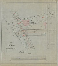
1832. April 30th. Resurvey. Draught of a contemplated street [Stanley, now Pemberton] 20 feet wide situate between Plum [Monroe] and German [Fitzwater] streets and extending from 3d to 4th streets as shown by the red lines south of and adjoining to [Pryor’s?] north line. Feby. 2d 1833. The above contemplated street altered to 25 feet wide. | Coombs, David | 1832 |
Paper
20 x 24 in.
|
South Philadelphia. Stanley (Pemberton) St. between Plum (Monroe) and German (Fitzwater) streets, 3rd to 4th streets
Property owners, buildings in street line
|
| 090-x HP |
|
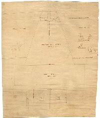
[No title. Centre Square, showing circular pathway around the square) | Hains, Samuel (probably) | 1820 ca. |
Paper
18 x 24 in.
|
Philadelphia. Centre Square, intersection of Broad and Market Sts.
Curb elevations
|
| 090-y HP |
|
Race St. Wharf by F. Graff Sr. Dec'r. 21. 1827. | Graff, Frederick, Sr. | 1827 |
Paper
19 x 22 in.
|
Philadelphia. Race St. at the Delaware River.
Proposed alterations, including pebble paving and culverts for drainage, to keep the wharf clean
|
| 090-z HP |
|
Proposed alteration of grades bet. Del'r. 8th & Broad. 1816 | Hains, Samuel (probably) | 1816 |
Paper
30 x 22 in.
|
Philadelphia. Bounded by Cedar (South) St. to Walnut St., 8th to Broad Sts.
Shackhanson Creek. Plan has lettered features, but the key (which looks to have once been attached) is missing.
|
| 091-01 HP |
|
Plan for road from Main St. in Frankford to Bridesburg. [The road, Harrison Street, was confirmed in 1847.] | Foulkrod, John (probably) | 1845 ca. |
Mounted
30 x 30 in.
1 inch = 200 feet
|
23rd Ward, road from Frankford to Bridesburg
Road petition, includes large sheaf of petition remonstrances etc.
|
| 091-01 HP documents |
|
[Petition, remonstrances, and depositions of 38 people regarding road described in 091-01_HP. Not all items scanned.] | 1845 ca. |
Paper
|
23rd Ward, road from Frankford to Bridesburg
Attachment
|
|
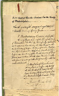
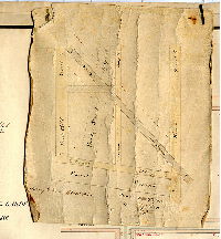
| 091-02 HP |
|
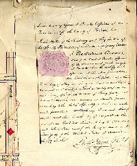
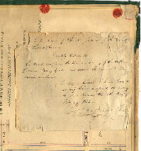
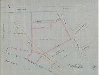
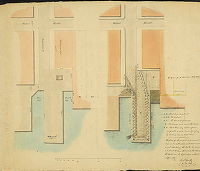
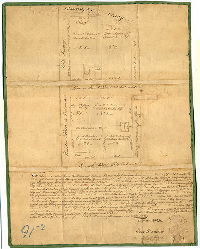
We Thomas Norton, Isaac W. Morris and William Penrose who have been chosen, nominated and appointed to make Partition and Division of those Messuages and Lots of Ground delineated in the above Plan or Draft late the Estate of Benjamin George Eyre deceased agreeable to his last will between Jacob Valentine and Elisabeth Ann his Wife and Samuel Robbins and Harriett his Wife the said Elizabeth Ann and Harriet being the two Daughters of the said Benjamin George Eyre deceased having carefully considered the situation of the Premises and the relative value of the Part thereof with another do part and divide the same in Way and manner set forth in the said Plan or Draft…Witness our Hands and Seals this Seventh Dan of the Fourth Month called April in the year of our Lord One thousand eight hundred and nine 1809. [Signed] Thomas Norton, Isaac W. Morris, William Penrose. | Norton, Thomas, et al. | 1809 |
Mounted
20 x 16 in.
1 inch = 50 feet
|
Bounded by Beach St. to Delaware River, Maiden St. to unnamed street on south
Partition of estate of Benjamin George Eyre; property lines, building footprints
|
| 091-t HP |
|
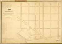
Plan of Market Street located in the Borough of Germantown by order of Town Council July 1851 by Joseph King, Jr. [Attachment not scanned: three "exceptions" protesting the plan] | King, Joseph, Jr. | 1851 |
Paper
13 x 62 in.
1 inch = 250 feet
|
Germantown Borough. Market St. (Chelten Ave.) from Wistar St. to Wissahickon Ave.
Streets and property lines
|