
Philadelphia Streets Department Surveys
2755 result(s). Showing results 351 to 400.
View page: 1 2 3 4 5 6 7 8 9 10 11 12 13 14 15 16 17 18 19 20 21 22 23 24 25 26 27 28 29 30 31 32 33 34 35 36 37 38 39 40 41 42 43 44 45 46 47 48 49 50 51 52 53 54 55 56 (Show all on one page)
| Identifer | Preview | Title | Surveyor | Date | Media / Size / Scale | Area / Map Features |
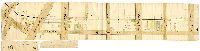
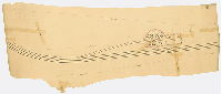
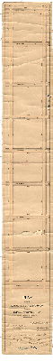
| 091-u HP |

|
Diagram of the roads in the lower end of the Roxborough Township. The dotted road along the Wissahickon Creek is the one which is the subject of the remonstrance. Scale of twenty poles to the inch. | Not named | 1845 |
Paper
20 x 27 in.
1 inch = 20 poles
|
Roxborough Township. Bounded by Wissahickon Ave. to Ridge Ave., Lincoln Drive to Kitchen's Lane
Wissahickon, Paper Mill Run (Monoshone Creek), six bridges, mills, dwellings
|
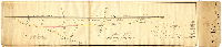
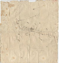
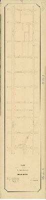
| 091-v HP |
|
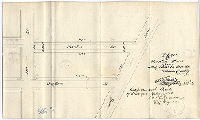
[No title. Prince St. [E. Girard Avenue], from Frankford Road to Hanover Street.] | Not named | 1816 ca. |
paper
10 x 53 in.
|
Prince St. [E. Girard Ave.], from Frankford Rd. to Hanover St.
Tinted building footprints, property owners, building types, e.g. "house," shop, stable, frame.
|
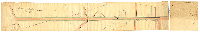
| 091-w HP |
|
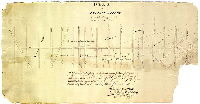
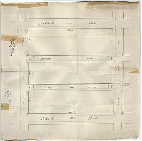
Plan shewing the direction of the Second Street Road if continued straight together with the Roads connected therewith. | Foulkrod, John | 1833 |
Paper
10 x 42 in.
|
Old Second Street, between Mascher and Calvert Sts.
Olney Road, Cayuga St., Wingohocking Creek, Thomas's Run, schoolhouse, Grubbtown Rd., "to Fox Chase," building footprints, creeks, property owners, building in right-of-way, bridge
|
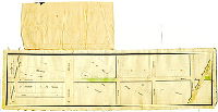
| 091-x HP |
|
Report of Viewers to widen Broad [in] Moyamensing. Plan of Broad Street continued through Moyamensing and part of Passyunk Township of the same width as it is in the City chewing [sic: shewing] the adjacent lands through which it passes and the quantity of ground it takes off each owners front. [June 6, 1835] | Rickey, Randall H. | 1835 |
Paper
9 x 53 in.
|
Broad Street. From Washington Ave. to Passyunk Ave.
Property owners, color coding of widening, dollars for damages, one building footprint
|
| 091-y HP |
|
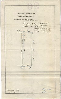
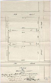
Eleventh Street, Poplar Street to old Master | Fox, Joseph | 1841 |
Mounted
28 x 8 in.
|
11th Street, from Poplar to Master Sts.
Property lines and ownership; attachment extending map
|
| 091-z HP |
|
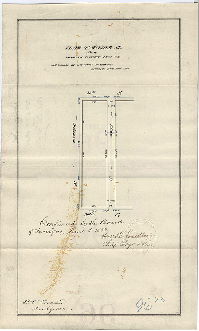
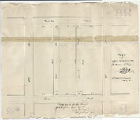
Plan of Poplar Street from the Ridge Road to the Pennsylvania Rail Road | Fox, Joseph | 1833 |
Paper
13 x 24 in.
|
Poplar St., between Broad and 18th Sts.
Property ownership
|
| 092-01 HP |
|
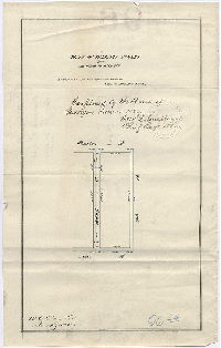
Myrtle Street extension, West Philadelphia. | Smedley, Samuel L., possibly | 1870 ca. |
Mounted
26 x 33 in.
|
West Philadelphia, Myrtle St. between Lancaster Ave. and the Pennsylvania Railroad.
Very limited delineation, plan seems unfinished
|
| 092-w HP |
|
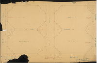
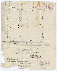
Plan of Rittenhouse Square. | Not named | 1840 ca. |
Paper
36 x 41 in.
|
Philadelphia. Rittenhouse Square
Delineates walkways on the perimeter, probably from when they were first constructed.
|
| 092-x HP |
|
[Handwritten title on reverse: "Streets near Manaiunk [Schuylkill] Bridge" | Not named | 1805 ca. |
Paper
23 x 23 in.
|
Philadelphia. Chestnut to Filbert Sts., Manaiunk (Schuylkill) Front St. (now 22nd St.) to "Maniaunk or Schuylkill" River
Bason (Basin) of the Schuylkill Pumping Station at the foot of Chestnut Street; this drew water from the Schuylkill and delivered it to a second pumping station at Centre Square
|
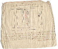
| 092-y HP |
|
[Title on reverse: "Iron railings Public Squares Old City." Railings in Penn, or Centre Square] | Not named | 1852 |
Paper
|
Philadelphia, Penn (or Centre) Square
Walkways and railings in Penn (Centre) Square
|
| 092-y HP reverse |
|
[Title on reverse: "Iron railings Public Squares Old City." Cartway entrances into Penn, or Centre Square] | Not named | 1852 |
Paper
|
Philadelphia, Penn (or Centre) Square
Cartway entrances to Penn (Centre) Square
|
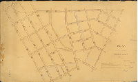
| 092-z HP |
|
[No title. Part of original city of Philadelphia. May be an early draft of 006-01_HP] | Howell, Reading, probably | 1809 ca. |
Paper
42 x 28 in.
|
Philadelphia. 22nd St. (Schuylkill Front St.) to 4th St., South (Cedar) St. to Vine St.
Streams penciled in, curb elevations
|
| 092-z HP reverse |
|
[No title. Draft plan of city. Note reads: "Old plan of the city of little value." ] | Not named | 1800 ca. |
Paper
|
Philadelphia
Sewers, drainage areas
|
| 094-x HP |
|
[No title. Turntable, engine house and workshop of Philadelphia, Wilmington & Baltimore Railroad, West Philadelphia] | Not named | 1860 ca. |
Paper
17 x 45 in.
|
West Philadelphia, Railroad. Turn-table of the Philadelphia, Wilmington & Baltimore, West Philadelphia side of the Gray's Ferry Bridge.
Turntable, engine house, and workshop
|
| 094-y HP |
|
[No title. Philadelphia, Wilmington and Baltimore Railroad through property of James Bartram and M. Newkirk. On reverse: "James Bartram No. 1"] | Not named | 1855 ca. |
Paper
18 x 17 in.
|
West Philadelphia. Railroad near Gray's Ferry.
Railroad, engine house, property lines and owners, roads
|
| 094-z HP |
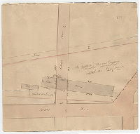
|
Property of the Trenton Railroad Company within the pink colored lines. | Moore, Benjamin | 1852 |
Paper
13 x 14 in.
|
Railroad property near Front and Cherry Sts.
Car house, office and shed, property lines
|
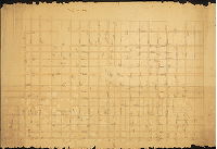
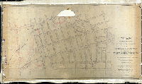
| 095-01 HP |
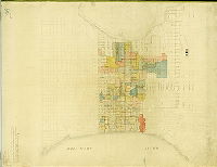
|
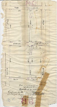
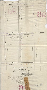
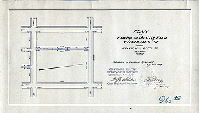
We hereby certify that the above plan for the numbering of houses in the City of Philadelphia and adjoining Districts was prepared by us in conformity with a resolution of the City Councils passed March 1st, 1838. Samuel Hains, City Surveyor. Philip M. Price, Surveyor, District of Spring Garden. | Hains, Samuel; Price, Philip M. | 1838 ca. |
Mounted
52 x 39 in.
1 inch = 500 feet
|
Philadelphia and adjoining municipalities.
Girard College, Market St. Canal, Fairmount, Cohocksink Creek, house numbers at block ends, drainage areas and sewers, detailed wharf line. Sewer lines and colored drainage areas were likely added later but probably before 1854.
|
| 096-22 HP |
|
Plan of Gerritt St. from Twentieth to Twenty-first Sts. [Ordinance Dec. 31, 1881; confirmed June 5, 1882] | Cranmer, William C. | 1882 |
Paper
15 x 9 in.
|
South Philadelphia. Gerritt Street
Curb elevations
|
| 096-23 HP |
|
Plan of Wilder St. from Twentieth to Twenty-first Sts. [Ordinance Dec. 31, 1881; confirmed June 5, 1882] | Cranmer, William C. | 1882 |
Paper
15 x 9 in.
|
South Philadelphia. Wilder Street
Curb elevations
|
| 096-24 HP |
|
Plan of Hillary St. from Wharton to Reed Sts. [Ordinance Dec. 31, 1881; confirmed June 5, 1882] | Cranmer, William C. | 1882 |
Paper
15 x 9 in.
|
South Philadelphia. Wharton Street
Curb elevations
|
| 096-25 HP |
|
Plan of lines and grade, Mole Street, Dickinson St. to Tasker St. [Ordinance March 17, 1884; confirmed Aug. 4, 1884] | Daly, Thomas | 1884 |
Paper
11 x 9 in.
|
South Philadelphia. Mole Street
Curb elevations
|
| 096-26 HP |
|
[Handwritten title on reverse: "Bancroft and Chadwick Sts., Dickinson to Tasker St. Ordinance June 29, 1883; confirmed August 4, 1884] | Daly, Thomas | 1884 |
Paper
17 x 16 in.
|
South Philadelphia. Bancroft Street and Chadwick Street
Curb elevations
|
| 096-27 HP |
|
Plan of lines and grade [of] Hicks Street, Reed Street to Tasker St. [On reverse: ordinance March 17, 1884; confirmed Aug. 4, 1884] | Daly, Thomas | 1884 |
Paper
17 x 9 in.
|
South Philadelphia
Curb elevations
|
| 096-28 HP |
|
Plan of lines and grade [of] Tiernan St, Reed St. to Tasker St. [On reverse: ordinance March 17, 1884; confirmed Aug. 4, 1884] | Daly, Thomas | 1884 |
Paper
18 x 8 in.
|
South Philadelphia
Curb elevations
|
| 096-29 HP |

|
Plan of Lambert, Sober and Woodstock Street from Dickinson to Tasker Street. [Ordinance June 22, 1885; confirmed Oct. 19, 1885 | Not named | 1885 |
Paper
17 x 12 in.
|
South Philadelphia. Lambert, Sober and Woodstock Streets
Curb elevations
|
| 096-29 HP tracing |
|
Plan of Lambert, Sober and Woodstock Street from Dickinson to Tasker Street. [Ordinance June 22, 1885; confirmed Oct. 19, 1885 | Not named | 1885 |
Tracing
17 x 12 in.
|
South Philadelphia. Lambert, Sober and Woodstock Streets
Curb elevations
|
| 096-30 HP |

|
Plan of Wilder St. from 19th to Twentieth St. [Ordinance Nov. 11, 1885; confirmed April 17, 1886] | Daly, Thomas | 1886 |
Paper
9 x 15 in.
|
South Philadelphia. Wilder Street
Curb elevations
|
| 096-31 HP |
|
Plan of Manton St. from Long Lane to 21st St. [Ordinance Nov. 11, 1885; confirmed April 19, 1886] | Daly, Thomas | 1886 |
Paper
10 x 16 in.
|
South Philadelphia. Manton Street
Curb elevations
|
| 096-32 HP |
|
Plan of Ward and Dorrance St. from Wharton St. to Lawrence Ave. [Ordinance Nov. 11, 1885; confirmed April 19, 1886] | Daly, Thomas | 1886 |
Paper
15 x 9 in.
|
South Philadelphia. Ward and Dorrance Streets
Curb elevations
|
| 096-33 HP |
|
Plan of Opal and Garnet Sts. from Dickinson to Tasker [Ordinance Nov. 11, 1885; confirmed April 19, 1886] | Daly, Thomas | 1886 |
Paper
13 x 16 in.
|
South Philadelphia. Opal and Garnet Streets
Curb elevations
|
| 096-34 HP |
|
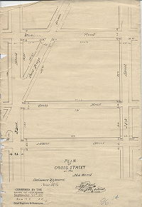
Plan of Cross Street in the 26th Ward. [Ordinance June 23, 1891; confirmed Sept. 21, 1891] | Daly, Thomas | 1891 |
Paper
17 x 12 in.
|
South Philadelphia. Cross Street
Curb elevations
|
| 096-35 HP tracing |
|
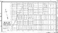
Plan showing the revision of lines and grades, in the Twenty-sixth Ward, Philadelphia [Ordinances 1866 and 1877; with late additions confirmed 1894 to 1899] | Webster, George S. | 1896 |
Tracing
28 x 51 in.
1 inch = 100 feet
|
South Philadelphia. 26th Ward. Bounded by Ellsworth to Tasker Sts., Broad to 22nd Sts.
Long Lane (Point Breeze Ave.) and other old roads, red ink annotations, curb elevations
|
| 096-39 HP |

|
Plan of triangular piece of ground at the intersection of 21s & Point Breeze Ave, 36th Ward. [Ordinance July 9, 1897; confirmed Dec. 6, 1897] | Daly, Thomas | 1897 |
Mounted
14 x 17 in.
|
South Philadelphia
Curb elevations
|
| 096-40 HP |
|
Plan for placing on the City Plan Chadwick St. from Wharton to Reed St., 26th Ward, Philada. [Ordinance July 9, 1897; confirmed Dec. 6, 1897] | Daly, Thomas | 1897 |
Mounted
9 x 16 in.
|
South Philadelphia. Chadwick Street
Curb elevations
|
| 096-41 HP |
|
Plan for placing on the City Plan Annin St., 20th to 21st Sts., 36th Ward. [Ordinance Dec. 8. 1897; survey returned Dec. 18, 1897; confirmed April 4, 1898] | Daly, Thomas | 1897 |
Mounted
9 x 17 in.
|
South Philadelphia. Annin Street
Curb elevations
|
| 096-43 HP tracing |
|
Plan 96 showing revision of lines and grades, in the 26th and 36th Wards, Philadelphia [Ordinance June 28, 1899; confirmed March 19, 1900] | Daly, Thomas | 1896 |
Tracing
30 x 51 in.
1 inch = 100 feet
|
South Philadelphia.. Bounded by Ellsworth to Tasker Sts., Broad to 22nd Sts.
Curb elevations
|
| 097-53 MTD |
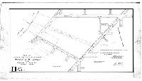
|
Plan for striking from City Plan and vacating Schuylkill Avenue from Christian St. to Peltz St., 30th Ward, Philada. [Ordinance Jan. 23, 1902; confirmed May 5, 1902] | Nobré, John M. | 1902 |
Mounted
17 x 30 in.
1 inch = 100 feet
|
South Philadelphia. Bounded by Schuylkill River, Christian St., Grays Ferry Ave., and Peltz St.
Curb elevations, railroad, vacated street
|
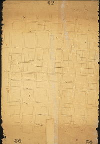
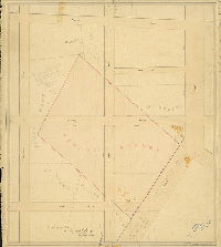
| 098 MTD |
|
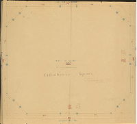
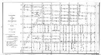
Plan of the revision of the Sixth Division of the survey and regulation of the late District of West Philadelphia [Act of Assembly May 1, 1852; resolution, Board of Commissioners, West Philadelphia, Oct. 13, 1852; revision authorized by resolution of Councils, date not given; confirmed March 1, 1875] | Hancock, George W. | 1875 |
Mounted
30 x 53 in.
|
West Philadelphia District, 6th Division. Bounded by Haverford and Lancaster Aves., 38th St., Market St. and 45th St.
Topography, Mill Creek and pond shown on grounds of Pennsylvania Hospital for the Insane, 42nd to 45th Sts.
|
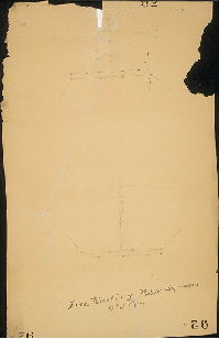
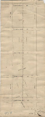
| 099-04 HP |
|
[No title. Parade ground at 11th and Wharton] | Daly, Thomas; Dye, John H. draftsman | 1859 |
Mounted
27 x 23 in.
1 inch = 50 feet
|
South Philadelphia, parade ground, Federal to Reed Sts., 11th to 13th Sts.
Parade Ground, property owners, pencil sketch of elevation of grandstand
|
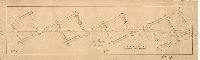
| 099-05 HP |
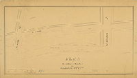
|
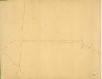
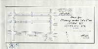
Plan of the revision of grades on Swanson Street. | Young, Alfred | 1861 |
Mounted
20 x 36 in.
1 inch = 30 feet
|
South Philadelphia. Swanson St., Christian St. to Washington Ave.
Profile of grade
|
| 099-06 HP |
|
Plan showing a proposed line for a railroad. | Daly, Thomas | 1865 |
Mounted
11 x 28 in.
|
South Philadelphia. Bounded by 25th to 29th Sts., Bigler to Pollock Sts.
Girard property, Union Land, property owners
|
| 099-07 HP |
|
Plan of survey and grade regulation on Long Lane from Federal to Mifflin St. | Daly, Thomas | 1870 |
Mounted
14 x 43 in.
|
South Philadelphia. Long Lane, Federal to Mifflin Sts.
Building footprint as benchmark
|
| 099-09 HP |
|
[No title. Placing Sanderson St., Harshaw St., and Birch St. on the City Plan. "All confirmed by Court Nov. 24th, 1869"] | Not named | 1869 |
Tracing
9 x 22 in.
|
South Philadelphia
Street lines
|
| 099-10 HP |
|
[No title. Placing Mount Holly St. and Bancroft St. on the City Plan. Confirmed by Court Nov. 29, 1869] | Not named | 1869. |
Tracing
7 x 14 in.
|
South Philadelphia
Street lines
|
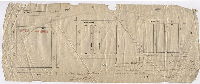
| 099-11 HP |

|
Plan exhibiting curb heights in part of the Twenty-sixth Ward in pursuance of a resolution of Councils approved April 18, 1864. [Approved by Board of Surveyors June 20, 1864; confirmed by Court May 15, 1871] | Not named | 1864 |
Mounted
25 x 30 in.
1 inch = 100 feet
|
South Philadelphia. South St. to Washington Ave., 22nd to Grays Ferry Ave.
Arsenal, asylum, benchmark buildings, sewers, railroad
|
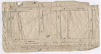
| 099-12 HP |
|
Plan of the revision of Wharton St. between Broad and Twenty-Second Sts. under a resolution of Councils of December 9th, 1864. Philada. Dec. 22nd, 1864. [Approved Board of Surveyors February 6, 1871. Confirmed May 15, 1871.] | Not named | 1864 |
Mounted
47 x 7 in.
|
South Philadelphia. Wharton St.
Street lines, streams at street crossings, building footprints
|
| 099-21 HP |
|
Plan showing the revision of the footways and grades on Broad Street. [Resolution May 19, 1873; confirmed by Board of Surveyors April 19, 1875] | Close, Charles S. | 1875 |
Mounted
14 x 61 in.
|
South Philadelphia. Broad Street, McKean to Ellsworth Sts.
Street lines
|
| 099-x HP |
|
[No title. Plan placing Bounty St. on the City Plan. Confirmed by Court Nov. 24, 1869] | Not named | 1869 |
Tracing
9 x 10 in.
|
South Philadelphia
Street plan
|
| 100-01 HP |
|
Plan of the Fifth Division of the Kensington District, surveyed and returned April 5th AD 1836 by Benjn. Moore. Revised March 5th 1844 by Benjn. Moore | Moore, Benjamin | 1844 |
Mounted
29 x 50 in.
|
Kensington District, 5th Division. Bounded by Hancock St. to West (Belgrade) St., Oxford to Norris Sts.
Norris' Line, benchmark buildings, sewers, railroad, old roads
|
| 100-01 HP attachment |
|
[Court confirmation of plan 100-01_HP] | 1837 |
Paper
|
Kensington District, 5th Division. Bounded by Hancock to West (Belgrade) Sts., Oxford to Norris Sts.
Attachment
|