
Search the collection of historic surveys and plans from the Philadelphia Streets Department.

| Identifier | Preview | Title | Surveyor | Date | Media / Size / Scale | Area / Map Features |
|---|---|---|---|---|---|---|
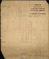
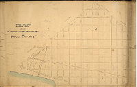
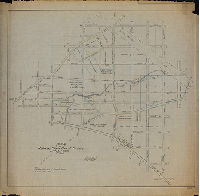
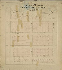
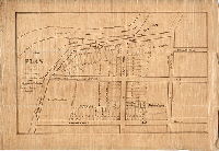
| SD5th-001 |

|
[No title: On reverse: "Joshua Lippincott property. 2nd St., Washington Ave., Clearfield to Westmoreland St."] | Not named | 1840 ca. |
Mounted 1 inch = 60 feet
|
North Philadelphia
Property subdivision
|
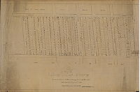
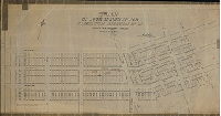
| SD5th-002 |

|
[On reverse: Lot subdivision, Susquehanna Ave. to York St., 22nd St. to 30th St.] | Not named | 1850 ca. |
Mounted 1 inch = 100 feet
|
North Philadelphia
Property subdivision
|
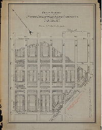
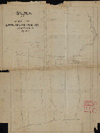
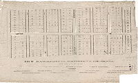
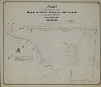
| SD5th-003 |
|
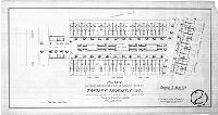
Plan or property in the Twenty-fifth Ward, City of Philadelphia, belonging to The Cohocksink Land Company | Not named | 1871 |
Mounted 1 inch = 120 feet
|
North Philadelphia
Property subdivision
|
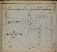
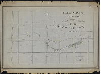
| SD5th-004 |

|
Plan and profile of the survey and regulation of Broad Street from Montgomery Street to Germantown Road in the Twenty-first Ward of the City of Philadelphia made by direction of the Chief Engineer & Surveyor. | Siddall, Joseph | 1856 |
Mounted 1 inch = 150 feet
|
Broad Street, North Philadelphia.
Similar to 137-01-HP (see), but this copy is dated and has many annotations in pencil, with calculations of amounts of cobblestones and macadam use, and property lines and owners. .
|
| SD5th-005 |

|
Plan of the Fair Hill Homestead Association, referred to in the Agreements of the purchases of lots, and intended to be forthwith recorded. Chas. Norris, Saml. Norris, Isaac Norris, Trustees of the Fair Hill Estate. Lith'y. of A[ugust] Kollner… Plan of the Fairhill Homestead Association ground in the District of Kensington. It is an elevated, handsome, & eligible site for Residences, being of convenient access to markets, Schools, Churches, & Omnibus, & within two Squares of hydrant water & pavements but a short distance from two public squares, & the Kensington Water-works. Geo. W. Ford, Jos. E. Baker, Jos. F. Burk, Jos. J. Sanders, Saml. Bechtold Jr., Committee. Michael Price, Agent for the Estate. E. O. Jackson, Sec. | Kollner, August | 1849 |
Mounted Not noted
|
North Philadelphia. Bounded by Dauphin St. to Lehigh Ave., Front St. to 2nd St.
Property subdivision. Toll gate on Second Street. Some properties marked "Sold."
|
| SD5th-006 |
|
Plan of lots of the Bridesburg Land Company situate in the Borough of Bridesburg, in the County of Philadelphia. Late the estate of Sergeant Dec'd. Surveyed and laid out as above delineated Sept. 1853 by John Foulkrod Survr. [Text on reverse: "Bridesburg, Buckius to Lefevre"] | Foulkrod, John | 1853 |
Tracing Not noted
|
Bridesburg. Bounded by Point Rd. to Frankford Creek, Buckius St. to Lefevre St.
Property subdivision
|
| SD5th-007 |
|
Plan of lots situate in the Borough of Frankford in the County of Philadelphia. The property of Charles Murphy. Surveyed as above and delineated Nov. 1849 by John Foulkrod Survr. | Foulkrod, John | 1849 |
Tracing 1 inch = 70 feet
|
Frankford. Bounded by Willow St. to Little Tacony Creek, Wakeling St. to Foulkrod St.
Property subdivision
|
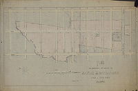
| SD5th-008 |
|
Topographical survey of the Cambria Reservoir site, Thirty-Eighth Ward, Philadelphia Pa. H. M. Fuller, Sur. & Reg. 13th Dist., March 21, 1901 | Fuller, H. M. | 1901 |
Tracing 1 inch = 70 feet
|
North Philadelphia. Bounded by Lehigh Ave. to Clearfield St., 27th St. to 31st St.
Topography, proposed reservoir for Philadelphia Water Department, footprints of buildings on Wharton family property called Bellevue.
|
| SD5th-009 |
|
Plan of the Sixth Section of the survey of Penn Township | Not named | 1841 |
Mounted Not noted
|
North Philadelphia. Bounded by 26th St., Allegheny Avenue and the Schuylkill River to "44th Street", and the boundaries of Roxborough and Germantown townships.
Same as 31-01-HP (see) but without full title block and with many penciled annotations: proposed streets, calculations, etc.]
|
| SD5th-010 |

|
Plan of Stouton Farm [Copy of Reading Howell plan] | Howell, Reading | 1799 |
Tracing Not noted
|
North Philadelphia
Property boundaries and owners, acreage, building footprints, Harrowgate garden, streams and mill races. Right side slightly cut off. Owners include General William MacPherson, Leonard Jacoby, John McAllister, Paul Beck, William Pointell, and Morris.
|
| SD5th-011 |
|
Plan of lots surveyed for the Hamilton Disston et. Al., Twenty-third Ward, Philadelphia. G. S. Webster, Surveyor and Regulator 10th Dist, July 18th 1887. | Webster, George S. | 1887 |
Tracing Not noted
|
North Philadelphia. Bounded by Dark Run Lane to Bridge St., Cottage St. to Jackson St.
Property subdivision, footprints of pre-existing buildings.
|
| SD5th-012 |

|
Plan of the proposed Frankford Park, Twenty-third Ward, Philadelphia. Geo. S. Webster, Surveyor and Regulator 10th Dist., March 17th, 1888. | Webster, George S. | 1888 |
Tracing 1 inch = 50 feet
|
Frankford. About 9 acres at the corner of Arrot St. and Castor Rd. This became Northwood Park (see SD5th-013, -014, and -015)
Park property.
|
| SD5th-013 |

|
Plan of Northwood Park, Twenty-third Ward, Philada. John H. Webster, Jr., Surveyor and Regulator 10th District, June 15, 1895. | Webster, John H., Jr. | 1895 |
Tracing 1 inch = 60 feet
|
Frankford. Park roughly at corner of Arrot St. and Castor Rd. (See SD5th-012, -014, and -015)
Topography, "small stream" (Little Tacony Creek), railroad
|
| SD5th-014 |
|
Plan of Northwood Park, Twenty-third Ward, Phila. J. H. Webster, Jr., Surveyor & Regulator 10th District, June 19, 1908. | Webster, John H., Jr. | 1908 |
Tracing 1 inch = 40 feet
|
Frankford. Park roughly at corner of Arrot St. and Castor Rd. (See SD5th-012, -013, and -015)
Topography, "small stream" (Little Tacony Creek), railroad
|
| SD5th-015 |

|
Topographical plan showing location of trees, one-foot contours, etc., of a portion of Northwood Park, Twenty-third Ward, Phila. J. H. Webster, Jr., Sur. & Reg. 10th Dist., June 12, 1901. | Webster, John H., Jr. | 1901 |
Tracing 1 inch = 20 feet
|
Frankford. Park roughly at corner of Arrot St. and Castor Rd. (See SD5th-012, -013, and -015)
Topography, "small stream" (Little Tacony Creek), trees with approximate trunk diameter.
|
| SD5th-016 |

|
Plan of lots surveyed for the North Frankford Land Company, Thirty-fifth Ward, Philadelphia | Webster, John H., Jr. | 1896 |
Tracing 1 inch = 60 feet
|
Frankford. Bounded roughly by Frankford Ave. to Walker St., Robbins St. to Devereaux St.
Property subdivision
|
| SD5th-017 |
|
Plan of lots surveyed for the North Frankford Land Company, Thirty-fifth Ward, Philadelphia | Webster, John H., Jr. | 1897 |
Tracing 1 inch = 100 feet
|
Frankford. Bounded roughly by Frankford Ave. to Brous St., Hellerman St. to Devereaux St.
Property subdivision
|
| SD5th-018 |
|
Plan for use of the Highway Committee of Councils, 25th and 35th Wards, Phila. | Webster, John H., Jr. | 1904 |
Tracing Not noted
|
Frankford. Bounded roughly by Frankford Ave., Oxford Ave., Castor Ave., and Devereaux St.
Property owners, Little Tacony Creek, proposed line of Roosevelt Boulevard
|
| SD5th-019 |
|
Plan of the Est. of Mathias Baldwin Dec[eased]. 23rd Ward. | Not named | 1870 ca. |
Tracing 1 inch = 80 feet
|
Wissinoming, Plan bounded roughly by Hegerman St. to the Delaware River, Wissinoming Creek to Vankirk St.
Building footprints: mansion house, greenhouse, stable, sheds, and pig pens; driveways, property subdivision. Wissinoming Creek, railroad. Plan stored in two halves, which were pieced together using Photoshop, but which do not match exactly along the seam
|
| SD5th-020 |

|
Plan of second allotment of lots belonging to The Baldwin Homestead Association of Wissinoming, Twenty-third Ward, Philadelphia. | Webster, George S. | 1888 |
Tracing 1 inch = 60 feet
|
Wissinoming. Bounded by Wissinoming Creek to Dark Run Lane, State Rd. to Delaware Ave.
Property subdivision
|
| SD5th-021 |

|
Plan of property surveyed for The Baldwin Homestead Ass'n., Thirty-fifth Ward, Phila. | Webster, John H., Jr. | 1895 |
Tracing 1 inch = 100 feet
|
Wissinoming. Bounded by Delaware Ave. to Delaware River, Vankirk St. to Devereaux Ave.
Property subdivision
|
| SD5th-022 |

|
Plan of lots belonging to The Baldwin Homestead Association of Wissinoming, Twenty-third Ward, Philadelphia. | Not named | 1888 ca. |
Mounted 1 inch = 60 feet
|
Wissinoming. Bounded by Wissinoming Creek to Dark Run Lane, Hegerman St. to State Rd.
Property subdivision
|
| SD5th-023 |

|
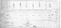
Plan of the change of grade of Orthodox Street from Torresdale Ave. Tacony St., Twenty-third Ward, Philada. | Webster, John H., Jr. | 1894 |
Tracing 1 inch = 80 feet
|
Frankford
Profiles along several streets, Little Tacony Creek running through center of Greenwood and Bault's Dye works (also known as Globe Dye Works).
|
| SD5th-024 |

|
[No title. On reverse: "Church St. from Torresdale to Melrose." Probably plan for grade crossing elimination at this location.] | Smedley, Samuel L., possibly | 1885 ca. |
Tracing 1 inch = 40 feet
|
Frankford
Probably a plan to eliminate dangerous railroad grade crossing at Church Street, by cutting the street down so it passes beneath the railroad. Two sisters were killed at this location on February 27, 1885, after which a public uproar led Councils to look
|
| SD5th-025 |

|
Copy of a portion of plans 270-278. Forty-first Ward, Phila. | Not named |
Tracing Not noted
|
Northeast Philadelphia. Bounded by Frankford Ave. to Torresdale Ave., Devereaux St. to Magee St.
Topography, Wissinoming Creek, Little Wissinoming Creek, trees, building footprints
|
|
| SD5th-026 |
|
Plan of property surveyed for John Overington in the Thirty-fifth Ward, Philadelphia. | Webster, John H., Jr. | 1893 |
Tracing 1 inch = 100 feet
|
Northeast Philadelphia. Bounded roughly by Magee St. to Levick St., Bustleton and Somerton Turnpike to Battersby St.
Building footprints: mansion, carriage house, barn, wooded areas, stream from spring house (tributary of Wissinoming Creek)
|
| SD5th-027 |
|
Plan of property surveyed for James G. Gillinder, Twenty-third Ward, Philadelphia. | Not named | 1886 |
Tracing Not noted
|
Northeast Philadelphia. Bounded by Hellerman St. to Walker St., Robbins St. to State Rd.
Building footprints, Wissinoming Creek and tributaries
|
| SD5th-028 |
|
Plan of lots surveyed for the Marburg Land Asso., Twenty-third Ward, Philadelphia. E. W. Smith & Co., Map Publisher, 20 So. Sixth St., Philada. | Webster, George S. | 1887 |
Mounted Not noted
|
Northeast Philadelphia. Bounded by Kensington and Oxford Turnpike to Lawndale St., Comly St. to Devereaux St.
Property subdivision
|
| SD5th-029 |

|
Plan of property surveyed for the Glebe Farm Land Company, Twenty-third Ward, Philadelphia. | Webster, George S. | 1888 |
Tracing 1 inch = 60 feet
|
Frankford. Bounded roughly by Adams Rd. to Grange Rd., H St. to G St.
Property subdivision
|
| SD5th-030 |
|
Copy of the official plan of the Cheltenham Mutual Land Association, Twenty-third Ward, Philadelphia | Not named | 1888 ca. |
Mounted
|
Northeast Philadelphia. Levick St. between G St. and Lawndale Ave.
Property subdivision. Plan lists officers and board of directors.
|
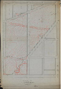
| SD5th-031 |
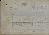
|
Plan of Luzerne St. from Rising Sun Ave. to Algon Ave., Thirty-third Ward, Philadelphia. Made for the Department of Law in the matter of the opening thereof under ordinance approved Dec. 1, 1911. | Brinton, Walter | 1912 |
Tracing 1 inch = 100 feet
|
Bounded by Lawrence St. to Algon Ave., Lycoming Ave. to Pike St.
Topography, tributary to Wingohocking Creek, building footprints, plots of New Cathedral Cemetery, Philadelphia Municipal Hospital
|
| SD5th-032 |

|
Plan made for use of the Highway Committee in the opening of Rising Sun Ave. from Germantown Ave. to Luzerne St. and from Third St. to Second St. also Luzerne St. from Rising Sun Ave. to Third St. and Third St. from Luzerne St. to Rising Sun Ave. Thirty-third Ward, Philadelphia. | Brinton, Walter | 1895 |
Tracing
|
North Philadelphia
Building footprints, property lines, owners, and valuations; North Pennsylvania Railroad, North Philadelphia Butchers and Drovers Live Stock Yard Association
|
| SD5th-033 |

|
Plan of lots of the Tabor Mutual Land Association. Walter Jones, Surv. & Reg'r. 9th Dist., Scale 80 ft. = 1 inch. Oct. 1887. F. Bourquin, Lith., 31 S. 6th St., Phila. | Jones, Walter | 1887 |
Mounted 1 inch = 80 feet
|
Crescentville. Bounded roughly by 5th St. to American St., Grange Ave. to Olney Ave.
Property subdivision. 343 building lots delineated. Original plan badly curled and cracked; scanned in 3 pieces and assembled in Photoshop.
|
| SD5th-034 |
|
Draft of James Benezet's Plantation and Tract of 64-3/4 Ac's. land situate in Oxford Township in the County of Philadelphia as survey'd. June 1764 and 1765 by (signed) (copy) Silas Watts. [Second survey dated 1785; "Traced by E.R.S. 1-4-09"] | Watts, Silas | 1785 |
Tracing Not noted
|
Oxford Township, Philadelphia County
Property plan
|
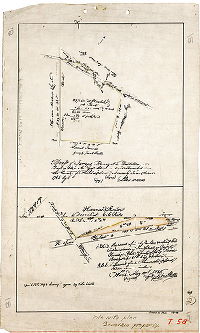
| SD5th-035 |
|
Plan of lots of the estate of Peter Buckius dec'd. and Rudolph N. Buckius in the Borough of Frankford. | 1847 ca. |
Tracing Not noted
|
Frankford
Property subdivision. Building lots, Baptist Church, German Church, Frankford Creek
|
|
| SD5th-036 |

|
Philadelphia December 5th 1868. James P. Davis, Sur. & Reg. Sixth District. [Extension of Clearfield Street between Frankford Road and Waterloo Street.] | Davis, James P. | 1868 |
Mounted Not noted
|
Clearfield Street.
Building footprints shown in line of proposed street.
|
| SD5th-037 |

|
Philadelphia February 4th 1871. James P. Davis, Sur. & Reg. Sixth District. Note.--Those lots which are enclosed in lilac colored lines belong to the estate of George W. Ford, deceased. | Davis, James P. | 1871 |
Mounted Not noted
|
North Philadelphia. Allegheny Ave. from Lambert St. to Delaware River.
Building lots, property lines, meadow bank along river
|
| SD5th-038 |

|
Plan for Har Nebo Cemetery. Jacob Herold, Architect, Office, 614 Chestnut Street, residence, 932 North Eleventh St. Philadelphia. | Not named | 1890 ca. |
Mounted 3 inches = 100 feet
|
Northeast Philadelphia. Current boundaries are Oxford, Devereaux and Summerdale avers.
Elevation of gatehouse
|
| SD5th-039 |

|
Plan of Joshua Hellerman's farm, Cheltenham Township, Mont. Co. Pa. Traced March 23, 1921 from original signed by Hunter & Evans, Engrs. & Surveyors, Jenkintown, Sep. 12, 1888. | Hunter & Evans | 1888 |
Tracing 1 inch = 100 feet
|
Cheltenham Township, Montgomery County
Building footprints, spring and tributary to Tacony Creek, Lawndale Station of Philadelphia, Newtown and New York Railroad, Cheltenham Land Association
|
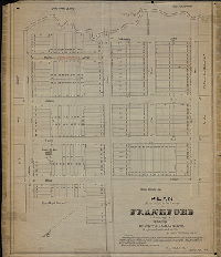
| SD5th-040 |

|
Plan of lots surveyed for the East Frankford Land Company in the Twenty-third Ward, Philadelphia. | Webster, John H., Jr. | 1894 |
Tracing 1 inch = 40 feet
|
Frankford
Property subdivision
|
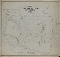
| SD5th-041 |
|
Plan of the property of Friends Asylum for the Insane in the Thirty-fifth Ward near Frankford, Philadelphia | Webster, John H., Jr. | 1892 |
Tracing Not noted
|
Friends Asylum (now Friends Hospital). Property bounded roughly (in 1892) by Philadelphia, Bustleton & Trenton Railroad, Adams (or Asylum) Road, Oakland Cemetery, and Tacony Creek
Building footprints, driveways, Lawnside mansion, Tacony Creek and pond, Oakland Cemetery, adjacent property owners
|
| SD5th-042 |
|
Plan of the property of Friends Asylum, Thirty-fifth Ward near Frankford, Philadelphia | Webster, John H., Jr. | 1910 |
Tracing 1 inch = 100 feet
|
Friends Asylum and surrounding property, bounded (in 1919) by Whitaker Ave., Loudon St., Wyoming Ave., Ramona Ave (Fisher's La.), Adams Ave., Roosevelt Boulevard, and Oxford Road Branch of the Connecting Railway
Building footprints, Tacony Creek Park, Oakland Cemetery Co., Connecting Railway, Roosevelt Boulevard
|
| SD5th-043 |
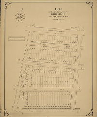
|
Plan of lots situated at Whitehall, Twenty-third Ward, Philadelphia. Thomas W. South, Agt. | Webster, George S. | 1880 |
Mounted Not noted
|
Whitehall. Bounded by Philadelphia and Kensington Railroad to Tacony St., Kennedy St. to Fraley St.
Property subdivision
|
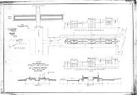
| SD5th-044A |
|
Plan showing improvement as a garden street. Twenty-seventh St. from Allegheny Ave. to Willard St., Thirty-eighth Ward, Philadelphia. | Fuller, Herbert M. | 1915 |
Tracing Not noted
|
North Philadelphia
Building footprints, design of garden features
|
| SD5th-044B |

|
Plan for the construction of granolithic steel-bound curb, granolithic steps and water and drain connections in the improvement of a park in the center of Twenty-seventh St. between Allegheny Ave. and Willard St., Thirty-eighth Ward, Philadelphia. [Garden street] | Fuller, Herbert M. | 1917 |
Tracing 1 inch = 20 feet
|
North Philadelphia
Architectural details
|
| SD5th-044C |
|
Plan of Park in 27th St. with cross sections showing present surface and finished grade. Thirty-eight Ward, Philadelphia [Garden street] | Fuller, Herbert M. | 1917 |
Tracing 1 inch = 20 feet
|
North Philadelphia
Street cross section
|
| SD5th-044D |

|
Plan for improvement of Twenty-seventh St. between Allegheny Ave. and Willard St. as a garden street, showing tiling parapet walls and steps on one quarter section of the central terrace. Thirty-eighth Ward, Philadelphia. | Not named | 1917 ca. |
Tracing 1 inch = 1 foot
|
North Philadelphia
Architectural details
|
| SD5th-044E |

|
Plan for improvement of Twenty-seventh St. between Allegheny Ave. and Willard St. as a garden street, showing tiling balustrade walls and steps on one quarter section of the central terrace. Thirty-eighth Ward, Philadelphia. | Not named | 1917 ca. |
Tracing 1 inch = 1 foot
|
North Philadelphia
Architectural details
|
| SD5th-044F |

|
Plan for improvement of Twenty-seventh St. between Allegheny Ave. and Willard St. as a garden street, Thirty-eighth Ward, Philadelphia. | Not named | 1917 ca. |
Tracing Not noted
|
North Philadelphia
Architectural details
|
| SD5th-044G |
|
Plan for improvement of Twenty-seventh St. between Allegheny Ave. and Willard St. as a garden street, Thirty-eighth Ward, Philadelphia. | Not named | 1917 ca. |
Tracing 1 inch = 20 feet
|
North Philadelphia
Architectural details
|