
Search the collection of historic surveys and plans from the Philadelphia Streets Department.

| Identifier | Preview | Title | Surveyor | Date | Media / Size / Scale | Area / Map Features |
|---|---|---|---|---|---|---|
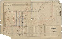
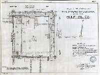
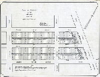
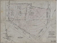
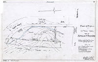
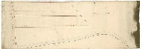
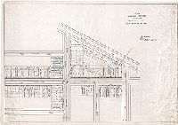
| SD7th-LPP-303 |
|
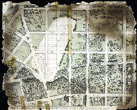
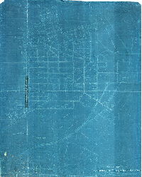
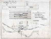
Plan of property of the Corporation of Haverford College, 34th Ward, Philadelphia. Total area = 104 157/1000 acres. Applications for purchase of any portion of this property may be made to the treasurer of the college. Asa S. Wing, 409 Chestnut St., Philadelphia. | Johnson, Joseph | 1897 |
Paper Not noted
|
West Philadelphia. Bounded roughly by Oxford St. and Lancaster Ave. to Media St., 56th St. to 64th St.
Property plan, topography, revised street names and locations added in ink. Restored digitally using two partial copies found in folder.
|
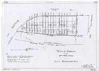
| SD7th-LPP-349 |
|
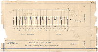
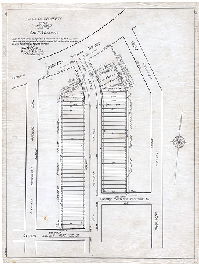
Plan of lots on the west side of Edgewood St. betw. Master + Media. F. C. Michaelsen, Builder, 834 Land Title Bldg. Feb. 1908. | Not named | 1908 |
Paper 1 inch = 20 feet
|
West Philadelphia.
Property subdivision, building footprints
|
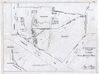
| SD7th-LPP-353 |
|
Plan of Overbrook Land and Improvement Co. 24th Ward, Philadelphia. Jos. Johnson, Sur. & Reg. 11th Dist. Scale 100' to 1 inch. [In pencil: "Date 9-25-1889"] | Johnson, Joseph | 1889 |
Blueprint 1 inch = 100 feet
|
West Philadelphia
Property subdivision
|
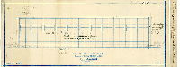
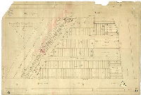
| SD7th-LPP-357 |
|
Stores & Dwellings at 62nd & Market Sts. for Messrs. Hopkins [and] Milgram. Anderson & Haupt, Architects & Engineers. 820 Drexel Building and 5312 Market Street, Philadelphia, PA. Order G-89, Sheet 1. Date: March 7, 1911. [] | Not named | 1911 |
Blueprint 1 inch = 8 feet
|
West Philadelphia
Property subdivision, building footprints. Many penciled notations on blueprint. On reverse in pencil: "Solomon Hopkins, Isador Milgram"
|
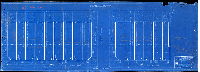
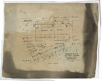
| SD7th-LPP-364 |
|
Plot plan of Sixty-second and Master Sts. F. C. Michaelsen, Contracting Builder. 845 Land Title. Scale 20' = 1 inch. Date: Sept. 15, 1910 | Not named | 1910 |
Blueprint 1 inch = 20 feet
|
West Philadelphia
Property subdivision, building footprints. Many penciled notations
|
| SD7th-LPP-366 |
|
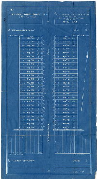
First Mortgages - 5-4/10% Ex. 5 years. Title, completion & against liens. Insured by The Land Title & Trust Company. Appl. No. 14700 | Not named | 1900 ca. |
Blueprint 1 inch = 30 feet
|
West Philadelphia, Robinson St. between Haddington St. and Lansdowne Ave.
Property subdivision, with mortgage amounts for each property. On reverse: "Davis Pennock, 5221 Webster St., Phila."
|
| SD7th-LPP-370 |
|
Jos. Johnson, Surveyor and Regulator, 11th District, Nov. 13th, 1903 | Johnson, Joseph | 1903 |
Tracing Not noted
|
West Philadelphia. Bounded by Columbia Ave. to Lancaster Ave., 61st St. to 63rd St.
Property subdivision. Part of property owned by Overbrook Land and Improvement Co.
|
| SD7th-LPP-390 |
|
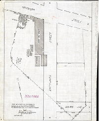
63rd & Media Streets, Philadelphia, Pennsylvania. Gulf Oil Corporation, Eastern Region - Engineering and Construction. Gulf Building, City Ave. at Schuylkill Expressway, Philadelphia, PA. | Not named | 1963 |
Blueprint 1 inch = 10 feet
|
West Philadelphia
Gas station. A plan of the house and garden that this gas station replaced can be seen in plan SD7th-LPP-390B
|
| SD7th-LPP-390B |
|
Plan of property in the 34th Ward made for Gulf Oil Co. | Stout, Dayton F. | 1963 |
Tracing 1 inch = 15 feet
|
West Philadelphia, 63rd St. and Media St.
Property plan. A plan of the gas station that replaced this house and garden can be seen in plan SD7th-LPP-390
|
| SD7th-LPP-403 |
|
64-1/2 St. or Simpson Street….64th Street…Callowhill Street…Carlton Street. [Subdivision plan, West Philadelphia] D. F. McConnell, 542 Land Title Bldg. Henry [H.? King? Kino?], Archt [Architect], 702 Land Title Bldg. March 22nd, 1904. | Not named | 1904 |
Blueprint 1 inch = 16 feet
|
West Philadelphia. 64th St. to 64-1/2 St., Carlton St. to Callowhill St.
Property subdivision
|
| SD7th-LPP-410 |
|
Woodcrest Avenue between Sixty-fourth and Sixty-sixth Streets. J. Franklin Moss & Co., Builders, Phila. Penna. Job No. 166, Sheet No. 1, February 1925. | Not named | 1925 |
Blueprint Not noted
|
West Philadelphia
Property subdivision with building footprints. Note in pencil: "This sketch used to fix the driveway grades."
|
| SD7th-LPP-431A |
|
Geo H. Weinrott, Owner & Builder, 1611 Walnut St. Philadelphia. Plot Plan Scale 1" = 40'-0. No. 1066. | Not named | 1925 |
Blueprint 1 inch = 40 feet
|
West Philadelphia, lots on both sides of 67th St. between Malvern Rd. and Oxford St.
Property subdivision with building footprints
|
| SD7th-LPP-431B |
|
Plan of property in the 34th Ward made for Geo. H. Weinrott. Plan made according to instructions of the applicant. Showing proposed sub-division of lots before the erection of any buildings or fences thereon. | Hyde, George W. | 1925 |
Tracing 1 inch = 40 feet
|
West Philadelphia, lots on both sides of 67th St. between Malvern Rd. and Oxford St.
Property subdivision
|
| SD7th-LPP-462 |
|
Plot plan of Sixty-fifth Street, Lansdowne Avenue to Jefferson Street. Moss & Taylor, Builders. April 26, 1920. Ralph F. Moss. | Not named | 1920 |
Blueprint 1 inch = 25 feet
|
West Philadelphia
Property subdivision with building footprints
|
| SD7th-LPP-467 |
|
[No title. Plan of property at 69th St. and Haverford Ave. that includes a large stone mill building and associated structures, including water tanks. "This plan for the purpose of conveyance only." ] | Johnson, Joseph | 1918 |
Tracing Not noted
|
West Philadelphia
Building footprints. This mill stood at the confluence of the east and west branches of Indian Creek.
|
| SD7th-LPP-488 |
|
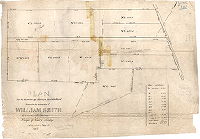
Plan for the division of a farm in the 24th Ward formerly property of William Smith. Containing 65.06 acres. Surveyed by Saml. L. Smedley, Philadelphia, 7 mo 1st 1857. Tracing made May 10, 93. M. E. H. | Smedley, Samuel L. | 1857 |
Tracing Not noted
|
West Philadelphia
Property subdivision. On reverse: "Farm formerly Wm. Smith 7/1/57. #53A, Case 1, Box 10B"
|
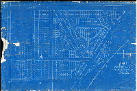
| SD7th-LPP-498 |
|
Plan of property in the 34th Ward made for John H. McClatchy. | Hyde, George W. | 1925 |
Tracing Not noted
|
West Philadelphia. Lots on Columbia Ave., Drexel Rd., and Woodbine Ave., and fronting on Haverford Ave.
Property subdivision. About 200 rowhouse lots.
|
| SD7th-LPP-500 |
|
[No title. Estate of Leonard Frailey.] | Not named | 1880 ca. |
Tracing Not noted
|
West Philadelphia, Indian Creek.
Indian Creek, building footprints, mill and mill race, pond, ice house, stable
|
| SD7th-LPP-531 |
|
Topographical plan of property situated in Thirty-fourth Ward, Philadelphia, PA., surveyed for the Philadelphia Fidelity Trust Co. | Albright & Friel | 1938 |
Blueprint 1 inch = 30 feet
|
West Philadelphia. Property fronting on City Ave. between Overbrook Ave. and 59th St.
Topography, building footprints, two houses individual trees named by type.
|
| SD7th-LPP-545 |
|
P.R.R. [Pennsylvania Railroad] P. T. Division. Proposed sale of property along Upland Way east of 59th St. to American Stores Company [now called ACME]. W. P. 6-29-49. | Not named | 1949 |
Blueprint 1 inch = 200 feet
|
West Philadelphia. Bounded roughly by Upland Way to Lancaster Ave., 52nd St. to Woodbine Ave.
Topography, railroad tracks and sidings, building footprints
|
| SD7th-LPP-546-1 |
|
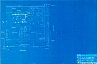
Survey & plan showing topography of properties in the 34th Ward made for Albert P. Gerhard | Shegog, George T. | 1937 |
Tracing 1 inch = 50 feet
|
West Philadelphia
Topography, building footprints, three houses individual trees located, "wooded area," driveways. A public school now occupies part of this property
|
| SD7th-LPP-546-2 |
|
Survey & plan of property in the 52nd Ward made for School District of Philadelphia. [Plan shows building footprints, and driveways. A public school now occupies part of this property.] | Shegog, George T. | 1948 |
Tracing 1 inch = 50 feet
|
West Philadelphia
Building footprints, three houses individual trees located, "wooded area," driveways. A public school now occupies part of this property
|
| SD7th-LPP-555 |
|
[No title. Topographic plan showing calculation of additional excavation required on adjoining private property by lowering of grade of Montgomery Avenue between 54th and 57th streets.] | Not named | 1920 ca. |
Tracing Not noted
|
West Philadelphia
Topography, estimates of cutting needed. One area requires excavation of 342,958 cubic yards
|
| SD7th-LPP-561 |
|
Daniel Crawford, Jr., Builder | Not named | 1922 |
Blueprint Not noted
|
West Philadelphia. Lots on Malvern Ave. and Woodcrest Ave, between 54thSt. and 56th St.
Property subdivision
|
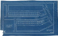
| SD7th-LPP-594A |
|
Plan of property in the 52nd Ward, Phila., made for Nathan R. Feldsher | Stout, Dayton F. | 1951 |
Tracing 1 inch = 40 feet
|
West Philadelphia. Lot at southeast corner of Bryn Mawr Ave. and Wynnefield Ave.
Topography. Vacant lot, the subdivision of which is shown in SD7th-LPP-594B
|
| SD7th-LPP-594B |
|
Plan of property in the 52nd Ward made for Louis Feldsher & Son | Stout, Dayton F. | 1951 |
Tracing 1 inch = 30 feet
|
West Philadelphia. Lot at southeast corner of Bryn Mawr Ave. and Wynnefield Ave.
Property subdivision of vacant lot shown in SD7th-LPP-594A; building footprints
|
| SD7th-LPP-614 |
|
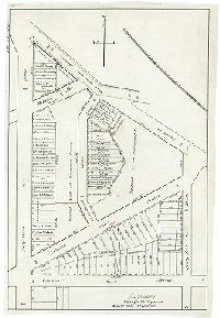
Sketch plan of [Philadelphia] Country Club's grounds & contiguous streets. | Not named | 1900 ca. |
Tracing Not noted
|
West Philadelphia. Bounded roughly by Schuylkill River to Ford Rd., City Ave. to Midvale Ave.
Building footprints on County Club property; dotted line indicating oval that was once a horse racing track, unnamed stream running into Schuylkill River upstream of Falls Bridge.
|
| SD7th-LPP-Burnt-01 |
|
Made for S. P. Shields, Dec. 3, 1890. Scale 100 foot to 1 inch. [Property plan with subdivision showing Mill Creek in area bounded by 42nd to 46th streets, Woodland Avenue and the Schuylkill River.] | Not named | 1890 |
Tracing 1 inch = 100 feet
|
West Philadelphia, Mill Creek. Bounded roughly by 42nd St. to 46th St., Woodland Ave. to Pennsylvania Railroad
Building footprints, Mill Creek, railroad tracks
|
| SD7th-LPP-Burnt-02 |
|
[No title. Mill Creek and Warren property along Woodward Street, to Schuylkill River. Also shows Woodland Cemetery. | Not named | 1880 ca. |
Mounted Not noted
|
West Philadelphia. Darby Road or Woodland Ave. to Schuylkill River, along line of Woodward Ave. and Mill Creek
Mill Creek, Woodland Cemetery
|
| SD7th-LPP-Burnt-03 |
|
Plan of 46th St. & Woodland Avenue. Total contents 177 lots. Scale 48 feet to one inch. S. R. 12/28/91. | Not named | 1891 |
Paper Not noted
|
West Philadelphia, Mill Creek. Bounded by 47th St. to 46th St., West Chester Branch of the Pennsylvania Railroad to Woodland Ave.
Property subdivision. Note in pencil: "Important plan. C. F. 10/1933." On reverse: 278. J. C. Moore. Linmore St.
|
| SD7th-LPP-Burnt-04 |
|
Plan of wharf property at the mouth of Mill Creek, 27th Ward, Philada. Jan. 21st, 1887. | Not named | 1887 |
tracing Not noted
|
West Philadelphia, Mill Creek. Bounded roughly by 42nd St. to 45th St., Woodland Ave. to Pennsylvania Railroad and Schuylkill River
Building footprints, wharf, railroad
|
| SD7th-LPP-Burnt-Gibson1 |
|
Plan of lots in the 27th Ward, Philadelphia, belonging to the estate of Mary Gibson, dec'd. Wm H. Jones, Surveyor, 12th District, Sept'r. 1885. Plan No. 3. Scale 120 ft. to 1 inch. Copy of lithograph made Nov. 17, 1891. | Jones, William H. | 1885 |
Tracing 1 inch = 120 feet
|
West Philadelphia. Bounded 48th St. to near 51st St., Paschall Ave. to the Philadelphia, Wilmington & Baltimore Railroad.
Property subdivision, copy of lithograph
|
| SD7th-LPP-Burnt-Satterlee |
|
Satterlee Heights (Satterlee Hospital grounds), 27th Ward, West Philadelphia | Not named | 1870 |
Paper Not noted
|
West Philadelphia, Mill Creek.
Property subdivision. Birds-eye view showing many buildings, trees, Mill Creek, lanes, and other features.
|
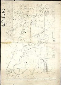
| SD7th-P10-F3-Cobbs |
|
Plan placing on the city plan that portion of Cobbs Creek Parkway and Park embraced with the limits of Plan No. 184, in the Fortieth Ward, Philadelphia. Authorized by ordinance of Councils approved June 27th, 1904 [Tracing copy (with topography added) made in 1912] | Gillingham, J. Harvey | 1904 |
Tracing 1 inch = 100 feet
|
West Philadelphia.
Topography. Quarries, Mt. Moriah Cemetery
|
| SD7th-P10-F3-ThomasRun |
|
Plan of survey and regulation of that portion of Fortieth Ward, Philadelphia, bounded by Fifty-sixth St., Cobbs Creek and Sixty-first St., Whitby and Springfield Avenues | Jones, William C. | 1902 |
Mounted Not noted
|
Southwest Philadelphia
Topography, building footprints, Thomas Run and Cobbs Creek, Grays Lane
|
| SD7th-P10-F4-CP246 |
|
Plan of the revision of lines and grades on the streets of Plan 246 in the 27th and 40th Wards, Phila., authorized by an ordinance of Councils approved September 21st, 1892. | Gillingham, J. Harvey | 1899 |
Tracing Not noted
|
West Philadelphia. Bounded by roughly by Woodland Ave. to Schuylkill River, 56th t. to 42nd St.
Building footprints, railroad tracks, bridges over Schuylkill River, riverfront topography, drainage ditches, Mill Creek Sewer, Perch Creek, section of Botanic Creek, Eastwick Property or Bartram's Garden
|
| SD7th-P10-F5-CP265 |

|
Plan of the revision of lines and grades with topography upon Plan No 265, Twenty-seventh Ward, Philadelphia. Ordinance of Councils approved January 29th, 1886. [Tracing copy made in 1909] | Jones, William H. | 1886 |
Tracing Not noted
|
West Philadelphia. Bounded by Woodland Ave. to Schuylkill River, 45th St. to Cleveland Ave.
Topography, Woodland Cemetery and plan of walkways, building footprints, railroads, Mill Creek, unnamed stream along line of present-day University Ave.
|
| SD7th-P11-F1-26 |
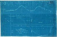
|
Plan showing profile and cross-sections along line of proposed main sewer in Fifty-seventh St. from Florence to Willows Av., Willows Av. From 57th to Frazier St., Frazier St. from Willows Av. To end of present sewer near Whitby Av. 40th Ward | Gillingham, J. Harvey | 1901 |
Blueprint 1 inch = 50 feet
|
Southwest Philadelphia.
Line of sewer projected to capture Thomas Run or Ameaseka Creek
|
| SD7th-P11-F1-8 |
|
Drainage Area, Lombard and Thirty-third Sts. Sewer [Beaver Creek] | Not named | 1900 ca. |
Blueprint 1 inch = 200 feet
|
West Philadelphia
Sewer drainage through what was the valley of Beaver Creek, from Powelton Village through the Penn Campus at 33rd Street
|
| SD7th-P11-F2-12-16 |
|
[No title. Part of a detailed map of Philadelphia, probably by E. P. Noll, ca. 1885, showing Schuylkill River and adjoining sections of South and Southwest Philadelphia.] ] | Not named | 1885 ca. |
Paper Not noted
|
Schuylkill River and adjoining neighborhoods, from University City south to the mouth
Refineries, grain elevator, drainage ditches, many named creeks, numerous railroad lines and passenger stations, many proposed streets and old lanes, This map section was apparently considered scrap, because on the reverse is a plan: "Proposed [sewer] rel
|
| SD7th-P11-F2-17 |
|
Plan and profile of sewer on Hadfield and Fifty-second Sts. From Phila. & Westchester R.R. to Whitby Ave. | Cubberley, F. H., draughtsman | 1880 ca. |
Photocopy 1 inch = 60 feet
|
West Philadelphia, Mill Creek
Sewer plan and profile, railroads
|
| SD7th-P11-F2-24 |
|
Plan showing locations and existing conditions of water supply pipes at West End Woolen Mills in Cobbs Creek Park | Gillingham, J. Harvey | 1914 |
Tracing 1 inch = 50 feet
|
West Philadelphia, Cobb's Creek
Building footprint of mill buildings, well locations, intakes at Cobb's Creek, profile showing various pipes
|
| SD7th-P11-F3-7 |
|
Drainage area of 46th Street Main Sewer, Mill Creek System. 12th Survey Dist. Dept. of Public Works, Bureau of Surveys, May 1896 | Not named | 1896 |
Blueprint 1 inch = 200 feet
|
West Philadelphia. Bounded by Sansom St. to Baltimore Ave., 44th St. to 53rd St.
Proposed and existing sewers with sizes and locations
|
| SD7th-P13-F1-2 |
|
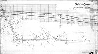
Plan and profile of proposed sewer on Robinson St., Race St., 62nd St., and Market St. from a point 150 feet south of Vine St. to Sixty-third Street. | Johnson, Joseph | 1900 |
Tracing 1 inch = 50 feet
|
West Philadelphia
Profile of original land elevations, unnamed tributary to Cobb's Creek, which was encapsulated in this sewer. See plan SD7th-JP-NOM-26 for upstream section of this stream.
|
| SD7th-P13-F1-3 |
|
Plan showing extension of branch of Merion Creek Sewer through private property from present terminus near Overbrook Ave. to City Avenue. [Tracing copy made in 1939] | Johnson, Joseph | 1902 |
Tracing 1 inch = 50 feet
|
West Philadelphia
Profile of original ground surface and cross section of sewer pipes; Merion Creek (Mill Creek tributary that crossed City Ave. at 59th St.)
|
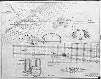
| SD7th-P14-F1-208 |
|
Mill Creek Sewer (as built.) Merion Creek Branch, south from chamber at Woodbine Ave. Department of Public Works, Bureau of Surveys, Philadelphia. B. E. Malone, contractor. Retuned by Jos. Johnson. | Johnson, Joseph | 1895 |
Tracing
|
West Philadelphia
Sewer Plan and profile
|
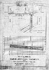
| SD7th-P14-F2-302 |
|
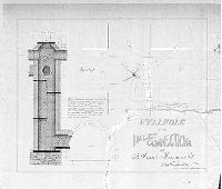
Wellhole and inlet connections at 63rd and Market St. | Smedley, Samuel L. | 1880 ca. |
Blueprint 1 inch = 20 feet
|
West Philadelphia
Sewer, plan and profile of wellhole
|
| SD7th-P14-F2-312 |
|
City of Philadelphia, Fairmount Park Commission. Cobbs Creek Park - vicinity of 69th St. showing channel change | Kenney, J. F. | 1958 |
Paper 1 inch = 500 feet
|
West Philadelphia and Upper Darby, Delaware County
Cobb's Creek - pan showing original location and new location, in relation to the county line and the property of the Philadelphia Transportation Co. at 69th Street.
|
| SD7th-P15-F1-407 |
|
Plan and profile of continuation of proposed Merion Ave. [Merion Creek] sewer though culvert at Overbrook. June 1906….Lower Merion Township...Robley A. Warner C.E., Supt. Health and Drainage | Not named | 1906 |
Blueprint 1 inch = 10 feet
|
West Philadelphia and Lower Merion Township, Montgomery County
Mill Creek Sewer underneath Overbrook Station, City Ave., and Pennsylvania Railroad tracks.
|
| SD7th-P15-F2-500 |
|
Plan showing sewers in vicinity of 38th and Brown St.'s. For the use of the Law Dep't. Jos. Johnson, Surveyor & Regulator, 11th Dist., August 10, 1899. | Johnson, Joseph | 1899 |
Tracing 1 inch = 40 feet
|
West Philadelphia. Shows sewers and houses on 37th, 38th, Brown, Linwood, DeKalb Sts. And Mantua Ave.
Building footprints, property lines and owners with additions in pencil. Portion of this sewer collapsed in June 1899, and again in August 1899; this plan was likely made in relation to claims against the city relating to these collapses. Most of the bloc
|