
Philadelphia Streets Department Surveys
2755 result(s). Showing results 2301 to 2350.
View page: 1 2 3 4 5 6 7 8 9 10 11 12 13 14 15 16 17 18 19 20 21 22 23 24 25 26 27 28 29 30 31 32 33 34 35 36 37 38 39 40 41 42 43 44 45 46 47 48 49 50 51 52 53 54 55 56 (Show all on one page)
| Identifer | Preview | Title | Surveyor | Date | Media / Size / Scale | Area / Map Features |
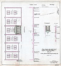
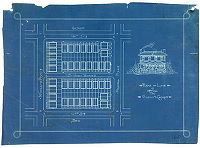
| SD7th-Airport-01-12 |
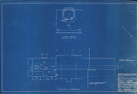
|
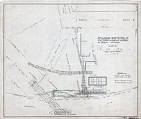
Administration building for S. Davis Wilson Air-Port, Island Ave. & Penrose Ave., Philadelphia, Penna. Building 1252, Drawing 12. Telephone and address system plans. Horace W. Castor, R.A. Date: Aug 30, 1938. Revised by the Department of City Architecture, Oct. 26, 1938. | Castor, Horace W. | 1938 |
Blueprint
24 x 36 in.
1 inch = 8 feet
|
Philadelphia Airport, Southwest Philadelphia
Technical drawing, set of 12
|
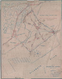
| SD7th-Airport-02 |
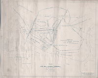
|
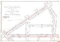
Plan of Air, Rail, Marine Terminal (Hog Island), Philadelphia, June 15, 1940. Bureau of Engineering, Surveys and Zoning, Philadelphia. | Not named | 1940 |
Blueprint
18 x 23 in.
1 inch = 1000 feet
|
Philadelphia Municipal Airport, Southwest Philadelphia, and vicinity
Airport details including runways, seaplane basin, various building footprints; also Fort Mifflin, railroads, and "proposed Delaware River vehicular tunnel"
|
| SD7th-Airport-03 |

|
A tree planting plan for the development of the headquarters of the 103rd Observation Squadron, P.N.G. [Pennsylvania National Guard], Philadelphia Airport, Philadelphia, PA. Commonwealth of Pennsylvania, Department of Internal Affairs…John W. Stoker, Landscape Architect. | Stoker, John W. | 1938 |
Blueprint
21 x 31 in.
1 inch = 20 feet
|
Philadelphia Municipal Airport, Southwest Philadelphia
Building footprints and uses, including administration building, hangar; gasoline pits; plan called for 6 sweet gum trees, 12 white oaks, and 11 pin oaks.
|
| SD7th-Airport-1938 |
|
Proposed change of line of Chester & Philadelphia and Sixtieth St. branches on account of Philadelphia Municipal Airport. Office of Chief Engineer, Eastern Region, P.R.R. [Philadelphia and Reading Railroad] | Not named | 1938 |
Photostat
13 x 22 in.
1 inch = 1000 feet
|
Southwest Philadelphia
Railroads, S. Davis Wilson Airport, runways, future location of sewage disposal works, property lines and ownership, Delaware and Schuylkill rivers, Fort Mifflin, Mingo Creek Pumping Station
|
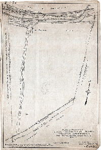
| SD7th-Airport-Can12-01 |

|
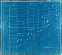
Plan showing tentative layout, Philadelphia Airport, Landplane, Penrose Avenue and Island Avenue, 40th Ward, Philadelphia. | Shedtler, Robert, and Fahy, C. A. | 1931 |
Tracing
70 x 54 in.
1 inch = 100 feet
|
Southwest Philadelphia
Taxiways, runways, hangars, grandstand, parking, lighting
|
| SD7th-Airport-Can12-02 |
|
Plan showing tentative layout, Philadelphia Airport and Rail-Marine Terminal | Shedtler, Robert, and Fahy, C. A. | 1931 |
Tracing
54 x 75 in.
1 inch = 200 feet
|
Southwest Philadelphia, Airport and vicinity
Layout of circular "all-way" landing area, administration building, parking, concessions, dirigible mooring, seaplane basin, hangars
|
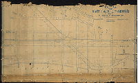
| SD7th-Airport-Can18-01 |

|
Airfield, S. Davis Wilson Airport, Philadelphia, Pennsylvania, January 20, 1938. 202G906. | Not named | 1938 |
Blueprint
36 x 90 in.
1 inch = 200 feet
|
Southwest Philadelphia, Airport and vicinity
Runways, Administration Building details, site plan
|
| SD7th-Airport-Can21-01 |

|
[Philadelphia Airport and Rail-Marine Terminal] Tentative study plan showing present drainage conditions | Fahy, C. A. | 1931 ca. |
Tracing
54 x 75 in.
1 inch = 200 feet
|
Southwest Philadelphia, Airport and vicinity
Showing creeks, roads, and railroads in the vicinity; Hog Island Shipyard
|
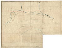
| SD7th-Airport-Can26-01 |

|
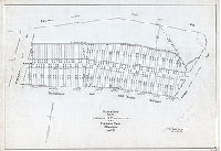
Plan of topographical survey of Philadelphia Terminal - Air - Rail - Marine [Airport] | Engle, Amos B. | 1930 |
Tracing
52 x 77 in.
1 inch = 200 feet
|
Southwest Philadelphia, Airport and vicinity
Hog Island Shipyard, elevations across the entire area, many below city datum; railroads, building footprints
|
| SD7th-Airport-FC1-01A |

|
Topographic plan of Philadelphia Southwest Airport in Philadelphia & Delaware Counties, Pennsylvania. June 10, 1946. Damon & Foster, Civil Engineers, Sharon Hill, Pa. [This is contiguous to RC-V-06] | Damon & Foster | 1946 |
Paper
54 x 77 in.
1 inch = 200 feet
|
Southwest Philadelphia and Airport
Topography, marshland, tidal creeks, railroads
|
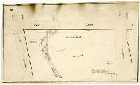
| SD7th-Airport-FC1-05 |
|
Plan of property of Edward F. Henson and John E. DuBois, showing physical conditions at north end, Tinicum Township, Delaware County, Penna. | Franklin & Co. | 1918 |
Tracing
27 x 18 in.
1 inch = 100 feet
|
Lowlands in Tinicum Township, Delaware County, abutting Fort Mifflin Property and Delaware River.
High and low water line, ditches, banks and dikes, Back Channel and excavated channel. Philadelphia, Baltimore and Washington Railroad and streetcar or trolley line, plank roadway
|
| SD7th-Airport-FC1-09 |
|
Map of Philadelphia Airport and vicinity. City Plans Division, Bureau of Engineering, Surveys & Zoning, Philadelphia. L. J. M. [delineator], 4-21-36 | L. J. M. | 1936 |
Paper
29 x 23 in.
|
Southwest Philadelphia and Airport and vicinity
Hog Island Shipways location, Southwest Sewage Treatment Plant site, runways and other features with many corrections and additions in ink and pencil
|
| SD7th-B-0046A-1 |
|
Plan of 4 pieces of ground in the 27th Ward Philadelphia intended to be exchanged. Ja. Miller, Sep. 1866 | Miller, James | 1866 |
Paper
10 x 16.5 in.
1 inch = 50 feet
|
West Philadelphia
Property exchange. Shows property lines and owners, and Mill Creek between Pine Street and Baltimore Avenue.
|
| SD7th-B-0046A-2 |
|
Plan of property belonging to estate of F. M. Drexel, dec'd., in the Twenty-seventh Ward, Philadelphia. | Jones, William H. | 1875 |
Mounted
11 x 10 in.
1 inch = 100 feet
|
West Philadelphia
Shows property lines and owners, and the course of Mill Creek between Pine Street and Baltimore Avenue.
|
| SD7th-B-0046A-3 |

|
Plan of property of Henry Mitchell, April 9, 1875. See pages 134 & 135, [Deed Book No. 1 | Not named | 1875 |
Paper, heavy
15 x 10 in.
1 inch = 50 feet
|
West Philadelphia
Shows property lines and owners, and the course of Mill Creek between Pine Street and Baltimore Avenue.
|
| SD7th-B-0046A-4 |
|
August 20th 1874. Squaring not carried out. [On reverse: 'Mitchell & Julius"] | Not named | 1874 |
Paper, heavy
12 x 17 in.
1 inch = 50 feet
|
West Philadelphia, between 42nd St. and 43rd St., Pine St. to near Baltimore Ave.
Shows property lines and owners, and the proposed swapping of property to "square" each lot. Mill Creek ran through these properties, between Pine Street and Baltimore Avenue.
|
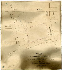
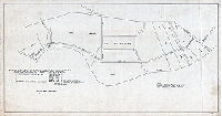
| SD7th-B-1078 |
|
Plan of proposed squaring between Thomas Marshall and Nathan Snellenburg, 27th Ward. | Gillingham, J. Harvey | 1902 |
Tracing
15 x 20 in.
1 inch = 40 feet
|
West Philadelphia. Bounded by 59th St. to 60th St., Walnut St. to Chestnut St.
Plan for "squaring" of property, where the property boundary between two owners cuts diagonally across the street grid, creating many triangular pieces of land that are far less valuable than the standard rectangular house lots.
|
| SD7th-B-1083 |

|
Plan of proposed squaring of lines between Estate of A. J. Drexel, dec'd. and Geo. W. and Mrs. L. H. Twaddell, 27th Ward. | Gillingham, J. Harvey | 1902 |
Tracing
15 x 20 in.
1 inch = 50 feet
|
West Philadelphia. Property line along Lombard (now Larchwood) St. between 45th St. and 47th St.
Plan for "squaring" of property, where the property boundary between two owners cuts diagonally across the street grid, creating many triangular pieces of land that are far less valuable than the standard rectangular house lots.
|
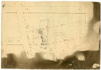
| SD7th-B-3000 |
|
Plan of the estate of Esther Byram Decd. To be sold by order of Trustees at Public Sale on Wednesday, June 17, 1863 at 12 o'clock noon at the Philadelphia Exchange by James A. Freeman, Auctioneer, No. 422 Walnut St. | Not named | 1863 |
Tracing
19 x 28 in.
1 inch = 100 feet
|
West Philadelphia. Bounded roughly by Mill Creek or Meadow St. to 49th St., Market St. to Walnut St.
Property subdivision showing 90 lots; also several building footprints, including "woolen [woolen] factory" and "machine shop" at 46th and Meadow sts.]
|
| SD7th-B-3009 |
|
Plan of squaring between Lucius S. Landreth and Thomas Marshall, 27th Ward Phila. | Gillingham, J. Harvey | 1901 |
Tracing
17 x 22 in.
1 inch = 50 feet
|
West Philadelphia. Bounded by 60th St. to 61st St., Chestnut St. to Walnut St.
Property subdivision. Shows proposed "squaring" or exchange of property to eliminate awkward triangular lots for each owner.
|
| SD7th-B-3033 |
|
Plan of Clarence H. Clark Park south of Chester Avenue in the Twenty-seventh Ward made for Bureau of City Property. | Gillingham, J. Harvey | 1903 |
Tracing
19 x 27 in.
1 inch = 50 feet
|
West Philadelphia. Triangular park area bounded by Chester Ave., 45th St. and 43rd St.
Park plan. Shows sewer lines to scale, and streets that were removed once park was established. This park area was never completely filled to the regulated street grade, is known locally as "the bowl."
|
| SD7th-B-3168 |

|
Plan of property in the Twenty-seventh Ward belonging to Est. Clarence H. Clark | Gillingham, J. Harvey | 1908 |
Tracing
21 x 28 in.
1 inch = 30 feet
|
West Philadelphia. Bounded by Lost St. to Spruce St., 42nd St. to 43rd St.
Outlines of driveways and various building footprints, including house, conservatory, stables, greenhouses, and boiler house
|
| SD7th-B-3215 |
|
Plan of lots made for Jesse R. Pharaoh in the Fortieth Ward, Philadelphia. | Gillingham, J. Harvey | 1912 |
Tracing
19 x 27 in.
1 inch = 50 feet
|
West Philadelphia. Bounded Thomas Ave. To 55th St., Baltimore Ave. to Philadelphia and West Chester Railroad
Property subdivision.
|
| SD7th-B-3227 |
|
Wm. H. Quick and Bros. | Not named | 1910 ca. |
Blueprint
19 x 22 in.
|
West Philadelphia. Bounded by Wharton St. to Baltimore Ave., 60th St. to 61st St.
Property subdivision.
|
| SD7th-B-3234 |

|
Plan of property belonging to the estate of Thomas Earley in the Fortieth Ward, Philadelphia. | Jones, William C. | 1913 |
Tracing
16 x 34 in.
1 inch = 100 feet
|
West Philadelphia. Bounded by 55th St. to 57th St., Springfield Ave. to Whitby Ave.
Topography, with total cubic yards of cut and fill calculated for the total property and for the area within the street lines.
|
| SD7th-B-3402 |
|
Plan showing proposed wharf on the Schuylkill River, vicinity of 51st Street produced southeast of Botanic Avenue, made for Geo. W. Smith and Co., for use of the Department of Wharves, Docks and Ferries. | Martin, G, G, | 1924 |
Tracing
20 x 24 in.
1 inch = 30 feet
|
Schuylkill River, West Philadelphia, at 51st Street. Industrial property just north of Bartram's Garden.
Shows outlet of 6.5 foot diameter sewer through proposed wharf; Baltimore and Philadelphia railroad tracks and bridge; steel tanks, building footprints, and existing wharf serving the "City of Philadelphia garbage reduction plant"
|
| SD7th-B-3420 |

|
Plan of property occupied by the Philadelphia Museums showing the lines as run from plans furnished by the District Surveyor. July 6, 1907 | Not named | 1907 |
Paper, heavy
20 x 30 in.
1 inch = 100 feet
|
West Philadelphia. Bounded roughly by South Street, 34th Street and the Pennsylvania Railroad.
Shows various museums of the city and University of Pennsylvania; Philadelphia Hospital and associated buildings; Children's Hospital, Nurses Home, and various University buildings.
|
| SD7th-B-3469 |
|
Plan showing wall, east side of Cobbs Creek Parkway, 100'-0" south of Ludlow Street made for The Atlantic Refining Company. | Martin, G, G, | 1928 |
Tracing
24 x 22 in.
1 inch = 5 feet
|
West Philadelphia.
Shows building elevations with details of windows and brickwork. Identical plan B-3070 made for Benjamin Herman and Joseph Bobb.
|
| SD7th-B-3499 |
|
Surve'd 6 mo. 16th 1835 by Joseph Fox. Copy: Original filed in Record Road Room Quarter Sessions - #687 City Hall, Steel Cabinet # 3 under counter, Road Cases - 1837. | Fox, Joseph | 1835 |
Tracing
16 x 31 in.
Not noted
|
Schuylkill River front property, West Philadelphia, from Chesnut Street to Grays property downstream of Mill Creek.
Property owners, Alms House yard, garden, and ground, greenhouse on Grays property.
|
| SD7th-B-5003 |
|
Plan of Sherwood, 27th Ward, Phil'a. | Not named | 1897 |
Tracing
41 x 27 in.
1 inch = 80 feet
|
West Philadelphia. Bounded by Baltimore Ave. to Whitby Ave., 56th St. to 58th St.
Property subdivision
|
| SD7th-B-5011 |

|
Plan of Sherwood, 40th Ward, Phila. | Not named | 1900 |
Tracing
41 x 28 in.
1 inch = 80 feet
|
West Philadelphia. Bounded by Baltimore Ave. to Whitby Ave., 56th St. to 58th St.
Property subdivision
|
| SD7th-B-588 |

|
Plan of property in the 27th Ward belonging to John Sellers | Gillingham, J. Harvey | 1898 |
Tracing
28 x 24 in.
1 inch = 20 feet
|
West Philadelphia. Vicinity of 63rd St. and Market St.
Elevation of bridge carrying Market Street over Cobb's Creek, tributary stream
|
| SD7th-Bingham-1 |

|
Draught of four lots or parcels of land belonging to the estate of the late William Bingham Esquire, deceased, situate in the Island and township of Tinicum, in the County of Delaware and State of Pennsylvania…June the 6th 1825, by Jno. Thomson [Tracing copy likely made by William H. Jones in 1884] | Thomson, John | 1825 |
Tracing
21 x 25 in.
1 inch = 20 perches
|
Tinicum Township, Delaware County
Property plan. Shows Bow Creek, Bow Creek Dam and Bow Creek Drain, as county line at edge of Philadelphia County; Church Creek and Church Creek Dam, trees depicted in various location including along Delaware River bank; Hog Island, Martin's Bar; adjacent
|
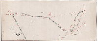
| SD7th-BowCreek-1884 |
|
Survey of a portion of Bow Creek, Nov. 1884 | Jones, William H. | 1884 |
Tracing
12 x 28 in.
Not noted
|
Southwest Philadelphia.
Bow Creek was the boundary between Philadelphia and Delaware counties
|
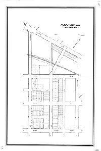
| SD7th-BP1-16 |
|
Draught of a piece or parcel of land, situated in the township of Kingsessing and County of Philadelphia, part of the Real Estate of Doctor Henry Paschall, deceased, containing sixty-seven [perches. Surveyed by Jno. Thomson December 7, 1837. [Tracing copy made in 1912] | Thomson, John | 1837 |
Tracing
9 x 15 in.
1 inch = 5 perches
|
Southwest Philadelphia. Meadow Road near Paschallville.
Property survey
|
| SD7th-BP1-17 |

|
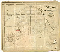
Plan of lots of the Delaware Land Company, 24th Ward Philadelphia. Office No. 50 Sth. 4th St. 2nd Story. Pillner Lith. 37-1/2 S. 3d St. | Not named | 1860 ca. |
Lithograph
17 x 19 in.
1 inch = 200 feet
|
Southwest Philadelphia. Bounded roughly by Massey St. to Paschall St., Springfield Ave. to Darby (Woodland) Ave.
Property subdivision, including building footprints, island, dam, race and bridge over Cobb's Creek, and some property owners.
|
| SD7th-BP1-17-attachment |

|
D 2163 (Registry Bureau number) April 30th, 1894 (Date of Deed) The 27th Ward Land Asso'n. to City of Philadelphia, for Greenway Avenue, Leslie and Upland Sts., Allman St., Chester Ave., 66th and 67th Sts. Approved by Board of Surveyors 2-2-1903, excepting Leslie Street (now Upland Street) N.E. of 66th St., which is not upon the City Plan. (Deed not recorded up to this time 3/28/18) | Not named | 1894 |
Paper
11 x 8.5 in.
Not noted
|
Southwest Philadelphia. 66th St., 67th St., Chester Ave., Allman St., Leslie St., Greenway Ave.,
Deed to City of Philadelphia for land encompassed by streets
|
| SD7th-BP1-56 |
|
Plan of lots of the Delaware Land Company in the 24th Ward Philadelphia. B. H. Haines 427 Walnut St. | Not named | 1860 ca. |
Lithograph
17 x 21 in.
1 inch = 160 feet
|
Southwest Philadelphia. Bounded roughly by 70th St. to 66th St., Springfield Ave. to Darby (Woodland) Ave.
Property subdivision, including building footprints, island, dam, race and bridge over Cobb's Creek. Many later additions in ink and pencil, noting lot purchasers and sales, deed book information, and calculations.
|
| SD7th-BP1-62 |
|
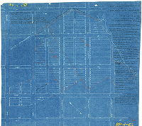
[Blueprint probably made from tracing of SD7th-BP1-56, "plan of lots of the Delaware Land Company," and including many additions in ink, including deed extracts different from those added to original plan | Not named | 1880 ca. |
Blueprint
16 x 18 in.
1 inch = 160 feet
|
Southwest Philadelphia. Bounded roughly by 70th St. to 66th St., Springfield Ave. to Darby (Woodland) Ave.
Property subdivision.
|
| SD7th-BP2-163 |
|
Plan of Paschall Village laid out by Henry Paschall in the Township of Kingsessing, vicinity of the Bell Inn, Philadelphia County, Pennsylvania, laid down by a scaling of 5 perches to the inch. Surveyed in August 1815, Thos. J. Paschall. (The above is a true copy of the original ... made Sept. 8, 1874) | Paschall, Thomas J. | 1815 |
Paper
19 x 20 in.
1 inch = 5 perches
|
Southwest Philadelphia, southeast of intersection of Island Rd. and Woodland Ave.
Property subdivision. Property lines and owners, including owners of neighboring tracts. Crude drawing of Bell Inn. Note in ink records source as "Record Book No. 2 Page 386"
|
| SD7th-BP3-15-3 |
|
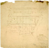
Plan of lots in 27th Ward for Gibson and Company | Not named | 1897 ca. |
Blueprint
11 x 16 in.
1 inch = 80 feet
|
Southwest Philadelphia, bounded by Woodland Ave. to Paschall St., 66th St. to 67th St.
Property subdivision, with drawing of sample house. Date determined from other dated plans of same blocks in same file, BP3-15-1 and BP3-15-2 (not catalogued).
|
| SD7th-BP5-Eastwick |
|
Plan of the estate of Andrew M. Eastwick, dec'd, in the Twenty-seventh Ward, Philadelphia | Murphy, Howard, Cicil Engineer, 326 Walnut St., Phila. | 1885 |
Blueprint
30 x 50 in.
1 inch = 100 feet
|
West Philadelphia
Railroads, building footprints, paper street lines, Schuylkill River
|
| SD7th-BP6-02 |

|
Grass lot belonging to estate of Jas. Harper dec'd., measured and divided June 28th 1874 as per directions of Paschall Lloyd. | Not named | 1874 |
Paper
12 x 26 in.
1 inch = 100 feet
|
Southwest Philadelphia. Property near Island Rd. and Powers' Lane.
Property subdivision, with owners and acreage. Many calculations on plan, in pencil
|
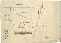
| SD7th-BP6-03 |
|
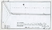
March 5, 1881. Proposed wharf [on Schuylkill River], W. W. Harkness | Not named | 1881 |
Paper
19 x 24 in.
Not noted
|
Southwest Philadelphia. Proposed wharf on line of 67th St. at Schuylkill River
Schuylkill River, soundings, river bank and unnamed tidal creeks. Bottom right corner missing.
|
| SD7th-BP6-04 |

|
Draught of a tract of land situate on State Island in the Township of Kingsessing and County of Philadelphia, belonging to the estate of the late William Bingham, Esquire, deceased,…Surveyed August the 4th 1825 by Jno. Thomson [Tracing copy made ca. 1884 by William H. Jones] | Thomson, John | 1825 |
Tracing
16 x 28 in.
1 inch = 20 perches
|
Southwest Philadelphia, Kingsessing Township
Property plan
|
| SD7th-BP6-07 |

|
Draught of three pieces or parcels of land belonging to the estate of the late William Bingham, Esquire, deceased, situate on Tinicum Island in the Township of Tinicum, Delaware County and State of Pennsylvania…Surveyed June the 3rd and re-examined and adjusted November the [2nd?] 1825 by Jno. Thomson ["Copied from a copy" in 1884 by William H. Jones] | Thomson, John | 1825 |
Tracing
18 x 22 in.
1 inch = 20 perches
|
Tinicum Township, Delaware County
Property plan.
|
| SD7th-BP6-10 |

|
[Title on reverse: "Province or State Island." This is a fragment of a larger plan.] | Not named | 1830 ca. |
Tracing
13 x 10 in.
Not noted
|
Southwest Philadelphia
Property plan
|
| SD7th-BP6-19 |

|
[Draft of land] belonging to the heirs of Mary Pancoast and Elizabeth Garret situate in the Township of Kingsessing Philada Co. exhibiting partition thereof to and among the same. [Plan incomplete. Tracing copy made ca. 1884 by William H. Jones] | Not named | 1850 ca. |
Tracing
19 x 18 in.
Not noted
|
Southwest Philadelphia, Kingsessing Township
Property plan
|
| SD7th-BP6-20 |

|
Draught of three lots or parcels of land belonging to the estate of the late William Bingham, Esquire, deceased … Surveyed June 9th 1825, by Jno. Thomson [Tracing copy made in 1884 by William H. Jones] | Thomson, John | 1825 |
Tracing
20 x 24 in.
1 inch = 20 perches
|
Southwest Philadelphia, Kingsessing Township
Property plan of land on Boon's Island and Carpenter's Island.
|
| SD7th-BP6-23 |
|
Draught of a piece or parcel of land in the township of Kingsessing in the County of Philadelphia, the property of John M. Justis, containing eighty acres and three-quarters and twenty-six perches. Surveyed Fby. 12 + 13, 1838 by Jno. Thomson. | Thomson, John | 1838 |
Paper
14 x 19 in.
1 inch = 20 perches
|
Southwest Philadelphia, Kingsessing Township.
Property plan. Unnamed creek and railroad.
|