
Philadelphia Streets Department Surveys
2755 result(s). Showing results 2351 to 2400.
View page: 1 2 3 4 5 6 7 8 9 10 11 12 13 14 15 16 17 18 19 20 21 22 23 24 25 26 27 28 29 30 31 32 33 34 35 36 37 38 39 40 41 42 43 44 45 46 47 48 49 50 51 52 53 54 55 56 (Show all on one page)
| Identifer | Preview | Title | Surveyor | Date | Media / Size / Scale | Area / Map Features |
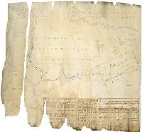
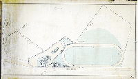
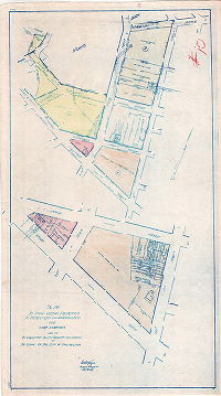
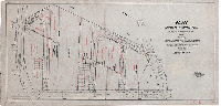
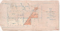
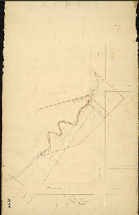
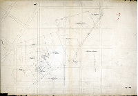
| SD7th-BP6-Bingham2A |
|
Draft of five pieces or parcels of land belonging to the estate of the late William Bingham, Esquire, deceased, situate on Tinicum Island in the Township of Tinicum, Delaware County and State of Pennsylvania…Surveyed June the 6th 1825, by Jno. Thomson [Tracing copy made in 1884 by William H. Jones] | Thomson, John | 1825 |
Tracing
21 x 24 in.
1 inch = 20 perches
|
Tinicum Township, Delaware County
Property plan. Besides William Bingham, owners include Thomas Smith, George Gesner, "Hunter's Land", John Serrill, and Richard Willing. Creeks shown include Bow, Middle , Longhock, Freeman's, Plum, Gron, Darby and "Bow Creek drain"
|
| SD7th-BP6-Bingham-2B |
|
Draught of five pieces or parcels of land belonging to the estate of the late William Bingham, Esquire, deceased, situate on Tinicum Island in the Township of Tinicum, Delaware County and State of Pennsylvania…Surveyed June the 6th 1825, by Jno. Thomson [Tracing of burned tracing copy originally made in 1884] | Thomson, John | 1825 |
Tracing
21 x 26 in.
1 inch = 20 perches
|
Tinicum Township, Delaware County
Property plan. Besides William Bingham, owners include Thomas Smith, George Gesner, "Hunter's Land", John Serrill, and Richard Willing. Creeks shown include Bow, Middle , Longhock, Freeman's, Plum, Gron, Darby and "Bow Creek drain"
|
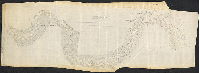
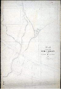
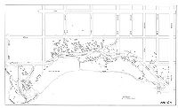
| SD7th-BP6-Schuylkill1879 |
|
Schuylkill River from Gibson's Wharf to the mouth. Surveyed November & December 1879. Copied from the original in the U.S. [Army Corps of Engineers] Engrs. Office [See Plan No. RC-N for different version of this plan without soundings and other details] | Not named | 1879 |
Tracing
35 x 96 in.
1 inch = 200 feet
|
Schuylkill River
Topography, soundings, marshland, river banks or dikes, tidal creeks, building footprints
|
| SD7th-C-11-2 |
|
[No title. Plan showing farm near Monument Road and Ford Road in West Philadelphia.] | Not named | 1850 ca. |
Paper
20 x 27 in.
Not noted
|
West Philadelphia
Stream and spring house depicted. Line of Belmont Avenue cuts through the farm; this plan was probably made to show the effect of this new road on the farm property. Also shows three two acre subdivided lots near County Line Road, now City Avenue.
|
| SD7th-C-12-11 |
|
[No title. Horse trotting or racing track on Mount Prospect Drive adjacent to West Fairmount Park, near the intersection of Belmont Avenue and Monument Road] | Not named | 1870 ca. |
Mounted
19 x 34 in.
1 inch = 80 feet
|
West Philadelphia. Fairmount Park
Horse track, building footprints, trees
|
| SD7th-C-12-FairmountLocks |
|
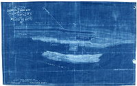
Tracing showing fence line of Schuylkill Navigation Co. at Fairmount Locks, 1883. Drawn under directions of Russell Thayer, Supt., Fairmount Park, by B. R. Evans, draughtsman. | Evans, B. R. | 1883 |
Blueprint
12 x 20 in.
1 inch = 60 feet
|
Schuylkill River and Fairmount Park.
Lock No. 71 of Schuylkill Navigation, showing Collector's Office
|
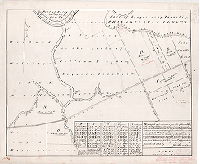
| SD7th-C-8-2 |
|
Plan of property belonging to the estate of Sarah M. Scull, 57th Street and City Avenue, Philadelphia | Johnson, Joseph | 1916 |
Linaura blueprint
40 x 24 in.
1 inch = 30 feet
|
West Philadelphia. 57th Street and Overbrook Avenue
Trees and shrubs located and named, building footprints of mansion, greenhouse, tenant house, and stable, driveways
|
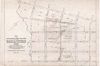
| SD7th-CCP-01 |
|
Index plan of the Eleventh Survey District Jury plans. Parks | Not named | 1910 ca. |
Diazoprint, color crayon on paper
24 x 33 in.
Not noted
|
West Philadelphia. Montgomery County, Delaware County, Schuylkill River
Color keyed index to plans in the eleventh survey district, including Cobbs Creek Park, numbered 1-10
|
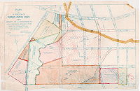
| SD7th-CCP-03 |
|
Plan to show certain properties to be selected and appropriated for park purposes made for the Committee on City Property and Service of the Council of the City of Philadelphia | Hyde, Geoffrey | 1926 |
Blueprint (positive), watercolor on paper
42 x 24 in.
1 inch = 1 foot
|
West Philadelphia. Haverford, Lansdowne, 68th street.
10 to index. Parcels with property ownership information
|
| SD7th-CCP-06 |
|
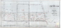
Plan for addition to Cobbs Creek Park of property bounded by Lansdowne Ave: Lebanon Ave, Haverford St. and Cobbs Creek Park, 34th Ward. Philadelphia. Prepared for the use of the Board of View in the matter of condemnation thereof, under ordinance approved Dec. 24, 1925, confirmed April 5, 1926. Lines and grades of streets authorized by ordinance of the Councils. Approved June 21, 1882. Confirmed Dec. 9, 1892. Approved Dec. 2, 1911. Confirmed June 1, 1914. | Hyde, Geoffrey | 1931 |
Blueprint (positive), watercolor on linen
32 x 67 in.
Not noted
|
West Philadelphia. Race, Lansdowne, Haverford, Rhoads
8 to index. Topography, property ownership, location, size and material (stone, frame) of buildings
|
| SD7th-CCP-07 |
|
Plan for addition to Cobbs Creek Park of property bounded by Lansdowne Ave: Lebanon Ave, Haverford St. and Cobbs Creek Park, 34th Ward. Philadelphia. Prepared for the use of the Board of View in the matter of condemnation thereof, under ordinance approved Dec. 24, 1925, confirmed April 5, 1926. Lines and grades of streets authorized by ordinance of the Councils. Approved June 21, 1882. Confirmed Dec. 9, 1892. Approved Dec. 2, 1911. Confirmed June 1, 1914. | Hyde, Geoffrey | 1931 |
Pen on linen
33 x 67 in.
Not noted
|
West Philadelphia. Race, Lansdowne, Haverford, Rhoads
8 to index. Topography, property ownership, location, size and material (stone, frame) of buildings
|
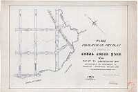
| SD7th-CCP-08 |
|
Plan for placing on city plan the portion of Cobbs Creek Park from 71st St. to Lansdowne Ave. Authorized by ordinance of Councils. Approved Nov. 5th, 1909. Confirmed by board of surveyors, March 21st, 1910. | Johnson, Joseph | 1910 |
Pen on linen
29 x 42 in.
1 inch = 100 feet
|
West Philadelphia. Lebanon, Race, Delaware County
7 to index. Topography, Indian Creek
|
| SD7th-CCP-09 |
|
Plan showing properties adjoining Morris Park in the 34th Ward appropriated for park purposes by resolution of the Commissioners of Fairmount Park. Dec. 10, 1924. Made for Board of View | Hyde, Geoffrey | 1925 |
Pen on linen
22.5 x 46 in.
Not noted
|
West Philadelphia. Malvern to Woodbine
6 to index. Property ownership and location of buildings
|
| SD7th-CCP-11 |
|
[No title. | Johnson, Joseph | 1903 |
Pen and color crayon on linen
29 x 48 in.
|
West Philadelphia. Haverford, City Avenue, 66th
5 to index. Street line and parcels
|
| SD7th-CCP-12 |
|
Plan of land adjoining Cobbs Creek Park between Arch St. , Race St. Lansdowne Ave. and low grade freight line of Penna. R.R. 34th ward Philadelphia. Made for the Board of View in conformity with a resolution of the Commissioners of Fairmount Park. Dated July 13, 1916. Lines and grades confirmed Jan. 4, 1909, June 1, 1914, March 3, 1916. | Johnson, Joseph | 1916 |
Pen on linen
32 x 47 in.
1 inch = 100 feet
|
West Philadelphia. Cobbs Creek, Woodbine, Lansdowne, Callowhill
4 to index. Topography and property ownership
|
| SD7th-CCP-13 |
|
Plan of a portion of Cobbs Creek Park from Daggett St. to Lansdowne Ave. as authorized by ordinance of Jan 25, 1917. Made for the Board of View. Lines and grades confirmed June 1, 1914. July 10, 1917 | Johnson, Joseph | 1917 |
Blueprint (positive), watercolor on paper
27 x 42 in.
|
West Philadelphia. Lansdowne, Haverford, Millbourne, 66th
3 to index. Topography and property ownership, building details
|
| SD7th-CCP-14 |
|
Plan of an addition to Cobbs Creek Park from Callowhill St. to Vine St. and from 69th St. to 66th St. as authorized by ordinance of Councils approved August 30, 1919. Made for the Board of View | Hyde, Geoffrey | 1919 |
Blueprint (positive) and watercolor on linen
24 x 47 in.
1 inch = 100 feet
|
West Philadelphia. Callowhill, Vine, 66th, 69th
3 to index. Topography and property ownership, building details
|
| SD7th-CCP-15 |
|
Plan of an addition to Cobbs Creek Park from Callowhill St. to Vine St. and from 69th St. to 66th St. as authorized by ordinance of Councils approved August 30, 1919. Made for the Board of View | Hyde, Geoffrey | 1919 |
Tracing
20 x 44 in.
1 inch = 100 feet
|
West Philadelphia. Callowhill, Vine, 66th, 69th
4 to index. Topography and property ownership, building details
|
| SD7th-CCP-16 |
|
Plan for addition to Cobbs Creek Park of ground bounded on north by Haverford Street and on the east by 68th Street, 34th ward, Philadelphia. Prepared for the use of the Board of View in the matter of condemnation thereof. Under ordinance approved July 11, 1924. Lines and grades of streets authorized by ordinance of Councils. Approved Dec. 2, 1911. Confirmed June 1, 1914. | Hyde, Geoffrey | 1930 |
Pen on linen
12 X 46 in.
Not noted
|
West Philadelphia. Haverford, 68th, Lansdowne
2 to index. Topography, property ownership, building details
|
| SD7th-CCP-20 |
|
Plan to accompany an ordinance showing tract of land in Delaware County to be made an addition to Cobbs Creek Park | Hyde, Geoffrey | 1928 |
Pen on linen
32 x 27 in.
Not noted
|
West Philadelphia. Cobbs Creek, City Line Ave, county line, Manoa Road
Street and boundary line
|
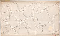
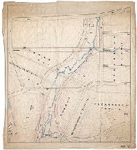
| SD7th-C-M-4-1 |
|
[No title. Indian Creek through Samuel Rhoads and James Wolfenden properties. On reverse: C.I. Box 9B, 387] | Hancock, George W. | 1872 |
Mounted
39 x 25 in.
1 inch = 30 feet
|
West Philadelphia. Indian Creek along Carter St. between Westminster Ave. and Girard Ave.
Property lines and owners, mill dam and race
|
| SD7th-C-M-4-2 |
|
Plan of ground of James Barlow in the Twenty-fourth Ward Philada. [Indian Creek in vicinity of 69th Street and Haverford Avenue] | Hancock, George W. | 1870 ca. |
Mounted
40 x 27 in.
Not noted
|
West Philadelphia. Indian Creek near 69th St. and Haverford Ave.
Property lines, mill race and pond, building footprint
|
| SD7th-C-M-4-3 |
|
[No title. Plan of Millbourne Mills Co. buildings at 63rd and Market streets, the property of William and John Sellers.] | Not named | 1910 ca. |
Tracing
34 x 44 in.
Not noted
|
West Philadelphia and Millbourne, Delaware County, along Cobbs Creek.
Building footprints, mill dam, mill race, property owners
|
| SD7TH-C-M-4-4 |
|
Plan showing approximate areas within division fence lines. 2-323/1000 acres in roadways. [Farm property or properties in West Philadelphia near Indian Creek] | Johnson, Joseph | 1893 |
Tracing
25 x 30 in.
Not noted
|
West Philadelphia. Bounded by Girard Ave. to Arch St., Indian Creek to 66th St.
Building footprints, Indian Creek, Cobbs Creek, agricultural uses of land, including type of crop and amount of land used. Crops include orchard, German millet, meadow, corn, wheat, grass,
|
| SD7th-C-M-4-5 |
|
[No title. Farm property or properties in West Philadelphia near Indian Creek. Working drawing for SD7th-C-M-4-4] | Not named | 1893 ca. |
Mounted
27 x 40 in.
Not noted
|
West Philadelphia. Bounded by Girard Ave. to Arch St., Indian Creek to 66th St.
Building footprints, Indian Creek, Cobbs Creek, agricultural uses of land, including type of crop and amount of land used. Crops include orchard, German millet, meadow, corn, wheat, grass,
|
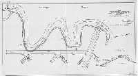
| SD7th-C-M-4-6 |
|
[No title. Plan showing Cobbs Creek between 63rd and 69th streets in Philadelphia, Millbourne, and Upper Darby.] | Johnson, Joseph | 1897 |
Tracing
23 x 38 in.
Not noted
|
West Philadelphia and Millbourne and Upper Darby, Delaware County. Bounded by 63rd St. to 69th St., Vine St. to Cobbs Creek.
Trees, lake formed by dam and mill race that led to Millbourne Mills.
|
| SD7th-C-M-6-6 |
|
[No title. On reverse: "Case 1 - Box 9 - 66th St. to 69th St. - City Ave. to Malvern Ave. - Revised street lines" showing curving streets laid out to cover the sewer (never built) that was planned to capture the East Branch of Indian Creek.] | Johnson, Joseph | 1897 |
Tracing
33 x 30 in.
Not noted
|
West Philadelphia. East Branch of Indian Creek, bounded roughly by City Ave. to Malvern Ave., 66th St. to 71st St.
East Branch of Indian Creek, mill races, spring houses, building footprints
|
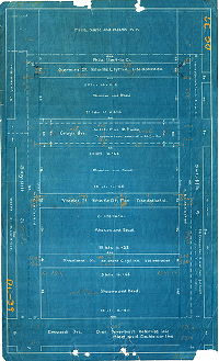
| SD7th-CP387-Property-1911 |
|
Registered owners, 40th Ward, June 1911 | Not named | 1911 |
Blueprint
25 x 22 in.
1 inch = 600 feet
|
Southwest Philadelphia
Property plan. Eagle Creek, Mingo Creek, Back Channel, Cabin Island, Mud Island, Fort Mifflin, mud flats along Schuylkill River at Delaware River, Southwestern Street Passenger railway Co., Penrose Ferry Bridge.. Largest landowners are City of Philadelphi
|
| SD7th-DC-03 |
|
Plan of the revision of lines and grades on that portion of Plan No. 152 between Seventieth and Upland Sts., Ann St. and Cobbs Creek, 27th Ward. Made in accordance with an ordinance of Councils approved June 29th, 1894. | Jones, William H. | 1895 |
Mounted
19 x 22 in.
1 inch = 100 feet
|
Southwest Philadelphia
Building footprints, railroad, Passmore's mill race
|
| SD7th-DC-03-3 |
|
Plan of the revision of lines and grades on that portion of Plan No. 152 between Seventieth and Upland Sts., Ann St. and Cobbs Creek, 27th Ward. Made in accordance with an ordinance of Councils approved June 29th, 1894. | Not named | 1895 ca. |
Mounted
19 x 24 in.
1 inch = 100 feet
|
Southwest Philadelphia
Topography, building footprints, railroad, Passmore's mill race
|
| SD7th-DC-06 |
|
Plan of the revision of lines and grades on that portion of Plan No. 152 bounded by Greenway Ave., Cobbs Creek & Seventieth St., 40th Ward. Made in accordance with an ordinance of Councils approved March 3rd, 1901. | Not named | 1901 ca. |
Tracing
18 x 21 in.
1 inch = 100 feet
|
Southwest Philadelphia
Building footprints, railroad, Passmore's mill race
|
| SD7th-DC-12 |
|
Plan of proposed revision of a portion of Plan No. 152, 49th Ward Phila. | Not named | 1901 ca. |
Tracing
19 x 24 in.
1 inch = 100 feet
|
Southwest Philadelphia. Bounded by Cobbs Creek to Kingsessing Ave., 69th St. to 72nd St.
Building footprints, railroad, Passmore's mill race
|
| SD7th-DC-39 |
|
[No title. Property of Shapiro and Reed, bounded by the Philadelphia, Washington and Baltimore Railroad and Elmwood Ave., 65th to 66th Street, with each section notated with number of lots to be made and their sizes. | Not named | 1910 ca. |
Blueprint
21 x 13 in.
1 inch = 50 feet
|
Southwest Philadelphia
Property subdivision
|
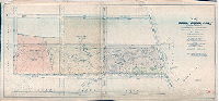
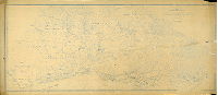
| SD7th-DelawareRiver-Can21-01 |
|
Map of the territory adjacent to the west side of the Delaware River from Philadelphia to the Delaware state line. Enlarged from maps of the United States Geological Survey. Philadelphia, 1918. General Plans Division, Bureau of Surveys. | C. L. Ryder, George M. Greene, and J. M. Hutchinson | 1918 |
Blueprint
48 x 111 in.
1 inch = 1000 feet
|
Delaware River front, west side, and adjacent communities, Philadelphia and Delaware counties.
Topography, railroad lines and stations, creeks, dams, wharves, roads, old names of places and villages, and many other details. On reverse, in red crayon: "1895/2236" and "Regional Planning Federation"
|
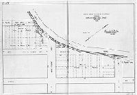
| SD7th-DP-01 |
|
Plan showing proposed construction along Darby Creek bank between King's Sluice and [Delaware] County line. | Engle, Amos B. | 1929 |
Tracing
20 x 36 in.
1 inch = 100 feet
|
Southwest Philadelphia between 92nd and 94th streets and Darby Creek.
Cross section of graded dike.
|
| SD7th-DP-05 |
|
Sketch made for Bureau of Highways showing break in Cobbs Creek Dyke, 40th Ward, Phila. | Thorpe, Frederick T., Jr. | 1930 |
Tracing
20 x 30 in.
1 inch = 40 feet
|
Southwest Philadelphia, 79th St. and Cobbs Creek
Dyke or dike along creek, subdivision of John H. Scott property along the creek, and other property owners
|
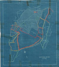
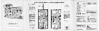
| SD7th-Eastwick-Brochure1 |
|
The Garden House. The Towne Gardens, Island Road & Turnstone Rd., Philadelphia 42, PA. SA7-8571. [One of four 4-page bifold brochures touting different house styles in the Eastwick Redevelopment area. Price noted in pencil: $13,400 ] | Not named | 1961 ca. |
Paper
|
Southwest Philadelphia, Eastwick Redevelopment Area
http://digital.library.temple.edu/cdm/ref/collection/p15037coll3/id/22638 has photographs of the Garden House as built, in 1962, which is where I got the approximate date for these brochures.
|
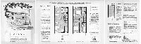
| SD7th-Eastwick-Brochure2 |
|
The Arbor House. The Towne Gardens, Island Road & Turnstone Rd., Philadelphia 42, PA. SA7-8571. [One of four 4-page bifold brochures touting different house styles in the Eastwick Redevelopment area. Price noted in pencil: $11,990 ] | Not named | 1961 ca. |
Paper
|
Southwest Philadelphia, Eastwick Redevelopment Area
http://digital.library.temple.edu/cdm/ref/collection/p15037coll3/id/22638 has photographs of the Garden House as built, in 1962, which is where I got the approximate date for these brochures.
|
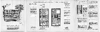
| SD7th-Eastwick-Brochure3 |
|
The Orchard House. The Towne Gardens, Island Road & Turnstone Rd., Philadelphia 42, PA. SA7-8571. [One of four 4-page bifold brochures touting different house styles in the Eastwick Redevelopment area. Price noted in pencil: $12,990] | Not named | 1961 ca. |
Paper
|
Southwest Philadelphia, Eastwick Redevelopment Area
http://digital.library.temple.edu/cdm/ref/collection/p15037coll3/id/22638 has photographs of the Garden House as built, in 1962, which is where I got the approximate date for these brochures.
|
| SD7th-Eastwick-Brochure4 |

|
The Terrace House. The Towne Gardens, Island Road & Turnstone Rd., Philadelphia 42, PA. SA7-8571. [One of four 4-page bifold brochures touting different house styles in the Eastwick Redevelopment area. Price noted in pencil: $14,490] | Not named | 1961 ca. |
Paper
|
Southwest Philadelphia, Eastwick Redevelopment Area
http://digital.library.temple.edu/cdm/ref/collection/p15037coll3/id/22638 has photographs of the Garden House as built, in 1962, which is where I got the approximate date for these brochures.
|
| SD7th-Eastwick-Brochure5 |

|
A guide to Eastwick redevelopment. The Citizens' Council on City Planning, 1717 Sansom Street, Philadelphia 3. [12-page pamphlet answering the questions, Where?, When? Why? How? and Who? regarding the redevelopment process in Eastwick. Includes 1954 map of existing land use in the redevelopment area, produced by the Philadelphia City Planning Commission.] | Not named | 1954 |
Paper
|
Southwest Philadelphia, Eastwick Redevelopment Area
|
| SD7th-Eastwick-Brochure6 |

|
Questions and answers on redevelopment in Eastwick. This pamphlet is presented to the Eastwick Community by the Eastwick Redevelopment Committee of Thirty. It was prepared by the Citizens' Council on City Planning, 1717 Sansom Street, Philadelphia 3, Pa. | Not named | 1955 ca. |
Paper
|
Southwest Philadelphia, Eastwick Redevelopment Area
|
| SD7th-FC5-01A |
|
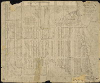
The Improved Mutual Land Association of the 27th Ward, Philadelphia | Not named | 1887 ca. |
Paper
16 x 24 in.
Not noted
|
Southwest Philadelphia. Bounded roughly by 85th St. to 88th St., Cullen Ave. to Tinicum Ave.
Property subdivision with descriptive text.
|
| SD7th-FC5-02A |
|
Plan of property in the 27th Ward Philadelphia belonging to Bernard C. Owens, a proposed to be divided into building lots. June 1888. | Not named | 1888 |
Tracing
28 x 18 in.
Not noted
|
Southwest Philadelphia. Bounded roughly by Tinicum Ave. to Eastwick Ave., 90th St. to 92nd St.
Property subdivision.
|
| SD7th-FC5-02B |
|
Plan of property of Bernard C. Owens, 40th Ward, June 1888, #18. [Tracing copy of SD7th-FC5-2A, made in 1934] | Not named | 1888 |
Tracing
26 x 17 in.
Not noted
|
Southwest Philadelphia. Bounded roughly by Tinicum Ave. to Eastwick Ave., 90th St. to 92nd St.
Property subdivision.
|
| SD7th-FC5-03 |
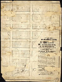
|
The Home Seekers Mutual Land Association [Newspapers.com search found 28 exact hits in Phila Times, earliest 1894] | Not named | 1894 ca. |
Paper
28 x 21 in.
Not noted
|
Southwest Philadelphia
Property subdivision
|
| SD7th-FC5-05 |
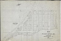
|
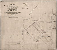
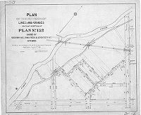
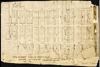
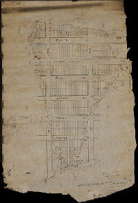
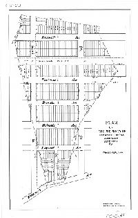
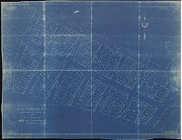
Map of Crescentville, 27th Ward, Philadelphia, PA. 1892. J. L. Smith, 27 So. 6th St. | Albright, Chester A. | 1892 |
Tracing
27 x 40 in.
1 inch = 75 feet
|
Southwest Philadelphia. Bounded by Laycock Ave. to Chester Branch of the Philadelphia and Reading Railroad, Alburger Lane to Bow Creek and 96th St.
Property subdivision. 473 house lots delineated. Copy of original,
|
| SD7th-FC5-06-1 |
|
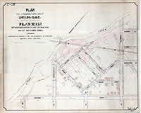
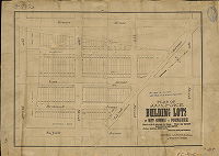
Plan of 200 choice building lots of West Suffolk or Paschalville. Board walk - 8 minutes - to Station. These are the most desirable lots in the market. Price, $100 to $200 each. Terms to suit purchasers. George Laycock, Owner, 914 Walnut Street. | Not named | 1889 ca. |
Paper
16 x 23 in.
Not noted
|
Southwest Philadelphia. Bounded by Gravers Ave. to Suffolk Ave., Island Ave. to 79th St.
Property subdivision. Two tracing copies, not scanned.
|
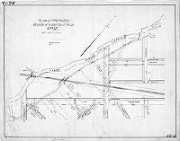
| SD7th-FC5-08 |
|
Plan of building lots, 90th Street and Tinicum Ave., for B. W. Melvin, 414 Real Estate Trust Bldg., Philadelphia. Durham Bros. Draughtsmen, Philadelphia, 10-16-15. | Durham Bros. | 1915 |
Blueprint
29 x 37 in.
Not noted
|
Southwest Philadelphia
Property subdivision
|
| SD7th-FC5-10-1 |
|
Lincoln Land Co. Building Lots. Trolley and Steam Roads Run Through the tract. Five-Cent Fare on Trolley Cars. W. G. Hill, on the premises. P. L. Hill, 8[__?] Walnut Street. | Not named | 1890 ca. |
Paper
15 x 18 in.
Not noted
|
Southwest Philadelphia
Property subdivision
|