
Philadelphia Streets Department Surveys
2755 result(s). Showing results 2401 to 2450.
View page: 1 2 3 4 5 6 7 8 9 10 11 12 13 14 15 16 17 18 19 20 21 22 23 24 25 26 27 28 29 30 31 32 33 34 35 36 37 38 39 40 41 42 43 44 45 46 47 48 49 50 51 52 53 54 55 56 (Show all on one page)
| Identifer | Preview | Title | Surveyor | Date | Media / Size / Scale | Area / Map Features |
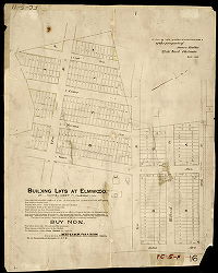
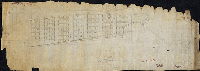
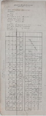
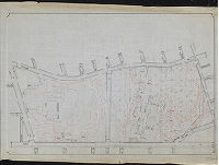
| SD7th-FC5-11A |
|
Building lots at Elmwood, 27th Ward, West Philadelphia. [In ink on lithograph: "Plan of the subdivision into lots of the property of James Dalton. 27th Ward Philada. Sept. 1889"] | Not named | 1889 |
Paper
21 x 16 in.
Not noted
|
Southwest Philadelphia
Property subdivision
|
| SD7th-FC5-11B |
|
Plan of Elmwood | Not named | 1890 ca. |
Tracing
30 x 33 in.
1 inch = 100 feet
|
Southwest Philadelphia. Bounded roughly by Tinicum Ave. to Scholl Ave.,86th St. to 90th St.
Property subdivision
|
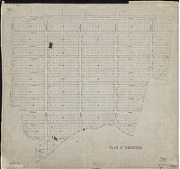
| SD7th-FC5-12 |

|
Tracing of plan belonging to Jos. H. Young , C.E., 806 Walnut St., Philadelphia. | Young, Joseph H. | 1895 ca. |
Tracing
31 x 34 in.
Not noted
|
Southwest Philadelphia
Property subdivision
|
| SD7th-FC5-14A |

|
East half of the town of Clear-View, Paschall or Clear-View Station, 27th Ward. F. Bourquin (lithographer), 31 S. 6th Str., Philada. | Bourquin, F. | 1889 ca. |
Paper
16 x 28 in.
1 inch = 200 feet
|
Southwest Philadelphia
Property subdivision
|
| SD7th-FC5-14B |
|
[No title. Lot subdivision of property between Dicks Avenue and Darby Creek, 79th and 82nd streets. "Old bed of Cobb's Creek - County Line" runs through the plan. Cox's Lane delineated as a dotted line; this was likely the only actual street shown on this plan.] | Not named | 1880 ca. |
Tracing
22 x 18 in.
Not noted
|
Southwest Philadelphia
Property subdivision
|
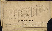
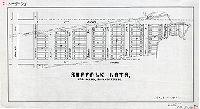
| SD7th-FC5-15 |
|
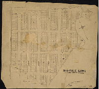
Suffolk Lots, 27th Ward, Philadelphia … One square from Suffolk Park, 8 minutes from Paschalville, and 14 minutes from Broad Street. Stage meets Trains at Paschall Station … Dry! Healthy! Improving! Lots 25 x 100 ft. Price $100. May be paid in $10 monthly installments. Dan F. Gillin, Printer, 717 Sansom St., Philada. | Not named | 1888 ca. |
Paper
18 x 30 in.
1 inch = 100 feet
|
Southwest Philadelphia. Bounded by 77th St. to 78th St., Chester Branch of the Philadelphia and Reading Railroad to Mingo Ave. or Mingo Creek.
Property subdivision with descriptive text.
|
| SD7th-FC5-16-1 |
|
Plan of a tract of land in the 27th Ward Phila. Belonging to George Laycock as proposed by him to be laid out into streets and lots. [On reverse: Jones [?] the [?] Oct 18[?] [Working plan for Suffolk Lots, see SD7th-FC5-15 and SD7th-FC5-16-2] | Jones, William H. | 1888 ca. |
Tracing
13 x 37 in.
1 inch = 100 feet
|
Southwest Philadelphia. Bounded by 77th St. to 78th St., Chester Branch of the Philadelphia and Reading Railroad to Mingo Ave. or Mingo Creek.
Property subdivision.
|
| SD7th-FC5-16-2 |
|
Suffolk Lots, 27th Ward, Philadelphia | Not named |
Tracing
16 x 29 in.
1 inch = 100 feet
|
Southwest Philadelphia. Bounded by 77th St. to 78th St., Chester Branch of the Philadelphia and Reading Railroad to Mingo Ave. or Mingo Creek.
Property subdivision. Tracking copy made in 1934, lacking descriptive text but otherwise identical to SD7th-FC5-15
|
|
| SD7th-FC5-16-3 |

|
Plan of property made for George Laycock | Not named | 1890 ca. |
Tracing
26 x 28 in.
1 inch = 100 feet
|
Southwest Philadelphia. Bounded by Chester Branch of the Philadelphia and Reading Railroad, Jones Lane or 77th St., Mingo Ave. or Mingo Creek, and Island Ave.
Property subdivision
|
| SD7th-FC5-17-1A |
|
High-Healthy-Homelike. Delightful Surroundings. West Philadelphia Building Lots. … No Wet Cellars. Convenient to the City. | Not named | 1888 ca. |
Paper
28 x 24 in.
1 inch = 100 feet
|
Southwest Philadelphia. Bounded roughly by Dickens or Buist Ave. to Eastwick Ave., 62nd St. to 65th St.
Property subdivision with descriptive text.
|
| SD7th-FC5-17-1B |
|
High-Healthy-Homelike. Delightful Surroundings. West Philadelphia Building Lots. … No Wet Cellars. Convenient to the City. | Not named | 1888 ca. |
Tracing
28 x 24 in.
1 inch = 100 feet
|
Southwest Philadelphia. Bounded roughly by Dickens or Buist Ave. to Eastwick Ave., 62nd St. to 65th St.
Property subdivision with descriptive text. This tracing copy, made in 1949, also includes added notes in pencil
|
| SD7th-FC5-18-1A |
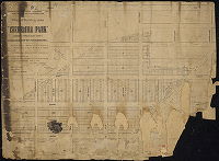
|
Plan of building lots of "Cherbourg Park" | Not named | 1890 ca. |
Paper
25 x 34 in.
1 inch = 100 feet
|
Southwest Philadelphia. Bounded roughly by Lyon Ave. to the Chester Branch of the Philadelphia and reading Railroad, 78th St. to 83rd St. or Mingo Creek.
Property subdivision with descriptive text.
|
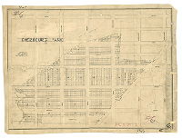
| SD7th-FC5-18-1B |
|
Plan of building lots of Cherbourg Park, Twenty-seventh Ward (now 40th Ward) Philadelphia [Tracing made in 1911] | Not named | 1890 ca. |
Tracing
28 x 38 in.
1 inch = 100 feet
|
Southwest Philadelphia. Bounded roughly by Lyon Ave. to the Chester Branch of the Philadelphia and Reading Railroad, 78th St. to 83rd St. or Mingo Creek.
Property subdivision
|
| SD7th-FC5-18-2 |
|
Cherbourg Park. Surveyed by Mr. Jones, District Surveyer [sic]. | Jones, William H. | 1890 ca. |
Paper
14 x 19 in.
Not noted
|
Southwest Philadelphia. Bounded roughly by Lyon Ave. to the Chester Branch of the Philadelphia and reading Railroad, 78th St. to 83rd St. or Mingo Creek.
Property subdivision.
|
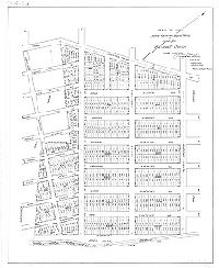
| SD7th-FC5-19-1A |

|
The Bartram Land Association of West Philadelphia. Lots 25-100 [feet] and larger $130-00/100 per lot. 5 cent fare Darby Car on Chestnut and Walnut or Spruce and Pine. Eng[raving] J. L. Smith, 27 So. 6th St. Phila | Not named | 1903 |
Paper
25 x 27 in.
1 inch = 100 feet
|
Southwest Philadelphia. Bounded roughly by Dicks Ave. to Brunswick Ave., 78th St. to 82nd St.
Property subdivision with descriptive text.
|
| SD7th-FC5-22 |

|
Building lots at Elmwood, 27th Ward, Philadelphia. [Handwritten title: "Plan of subdivision into lots of the property of Wm. Dalton, 27th Ward, Philada. March 1889."] | Not named | 1889 |
Paper
22 x 20 in.
Not noted
|
Southwest Philadelphia
Property subdivision.. Same as SD7th-FC5-11A but lacking descriptive text]
|
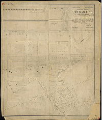
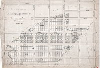
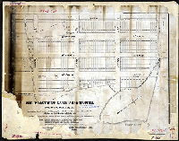
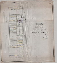
| SD7th-FC5-23 |
|
Plan of lots in the Fortieth Ward made for William T. Smith [Tracing copy made 1926] | Gillingham, J. Harvey | 1904 |
Tracing
30 x 25 in.
1 inch = 100 feet
|
Southwest Philadelphia. Bounded by Tinicum Ave. to Church Creek, 83rd St. to 86th St.
Property subdivision. About 600 house lots delineated. Note in pencil plan reads: "See plan work sheet C.P. 356 of Elmwood Land Association." Exact blueprint copy of this plan in 7th Survey Files, FC5-24, only differs in part of title block: "Plan of lots
|
| SD7th-FC5-25 |
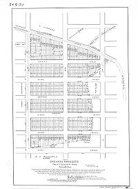
|
(Copy) Orchard Park Lots, Twenty-seventh Ward, Philadelphia. | Jones, William H. | 1891 |
Tracing
30 x 21 in.
1 inch = 100 feet
|
Southwest Philadelphia. Bounded by Tinicum Ave. to Scholl Ave., 82nd St. to 83rd St.
Property subdivision.
|
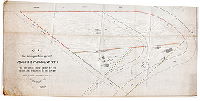
| SD7th-FC5-26A |
|
The Provident Land Association, 27th Ward, Philadelphia | Not named | 1887 ca. |
Mounted
20 x 25 in.
Not noted
|
Southwest Philadelphia. Bounded roughly by Chester Branch of the Philadelphia and Reading Railroad to Botanic Ave. and Land's Creek, 74th St. to 77th St. and Jones Lane
Property subdivision.
|
| SD7th-FC5-27 |

|
Plan of lots of the Elmwood Realty Company in the 40th Ward, Philadelphia. Office: No. 1301 Wolf Street. Jos. H. Young, Surveyor, Percy Building, Phila. | Young, Joseph H. | 1895 ca. |
Blueprint
19 x 14 in.
Not noted
|
Southwest Philadelphia. Bounded by Tinicum Ave. to the Chester Branch of the Philadelphia and Reading Railroad, 82nd St. to 83rd St.
Property subdivision. 106 house lots delineated, some marked "sold."
|
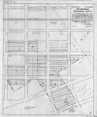
| SD7th-FC5-28 |
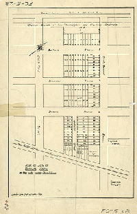
|
Plan of lots of Boone Park in the 40th Ward, Philadelphia. | Not named |
Paper
18 x 12 in.
1 inch = 80 feet
|
Southwest Philadelphia. Bounded by Tinicum Ave. to Chester Branch of the Philadelphia and Reading Railroad, 82nd St. to 83rd St.
Property subdivision.
|
|
| SD7th-FC5-29A |
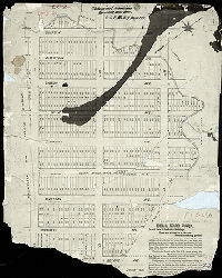
|
Bell Road Park (Gladwyn Land Association) | Jones, William H. | 1888 |
Mounted
24 x 19 in.
Not noted
|
Southwest Philadelphia. Suffolk Ave. to Botanic Ave., 83rd St. to 85th St.
Property subdivision.
|
| SD7th-FC5-30 |
|
Suffolk Lots, 27th Ward, West Philadelphia. F. Bourquin, Lith., 31 S. 6t St. Philada. | Not named | 1890 ca. |
Paper
24 x 26 in.
1 inch = 100 feet
|
Southwest Philadelphia. Bounded roughly by Jones Lane of 72nd St. to 80th St. or Island Rd., Mingo Ave. and Mingo Creek to Bartram Ave. or Chester Branch of the Philadelphia and Reading Railroad.
Property subdivision
|
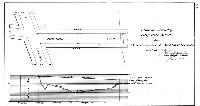
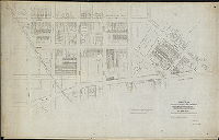
| SD7th-FC6-23 |
|
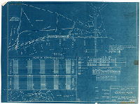
Bulkhead, Schuylkill River - west side, south of Penrose Ferry Bridge. Location plan [for borings]. Scales as noted. City of Philadelphia, Department of Wharves, Docks and Ferries. 3 sheets - Sheet No. 1. 2B-103 | Not named | 1919 ca. |
Blueprint
22 x 30 in.
1 inch = 100 feet
|
Schuylkill River at Penrose Ferry (now Platt) Bridge.
Borings indicating material (mud, gravel, sand, clay, etc.) found in the river bank and bottom.
|
| SD7th-FC9-03 |
|
Map of property in Philadelphia and Delaware County owned by John Black and Edgar A. Black. Made by G. P. N. Sadler. [Better copy, perhaps the original, of plan already scanned as RC-K-1, from City Plans Unit Red Can K] | Sadler, G. P. N. | 1874 |
Tracing
41 x 99 in.
1 inch = 200 feet
|
Southwest Philadelphia
Property lines, building footprints, creeks, bridges, river bank
|
| SD7th-FC9-06 |

|
Plan [of property in Southwest Philadelphia] traced from blueprint provided by Damon & Foster [Tracing copy made in 1929 by P. W. M. Yeager] | Phillips, J. W. | 1884 |
Blueprint
28 x 67 in.
1 inch = 400 feet
|
Southwest Philadelphia. Property at the confluence of the Schuylkill and Delaware River in Philadelphia and Delaware counties.
Little Smith, Tinicum, Hog, and Maiden islands, Fort Mifflin, marshland
|
| SD7th-FC9-13 |
|
Delaware River. Fort Mifflin & Vicinity. Us. Engineer Office, Phila., PA. Feb. 26, 1855 … Traced from copy of original drawing by John F. Engle … 1915. File No. 71-c 1086 | Sanders, John, and Engle, John F. | 1855 |
Blueprint
21 x 33 in.
1 inch = 500 feet
|
Southwest Philadelphia.
Text discusses condition of and repairs to dikes, sluices, wharves, and roads.
|
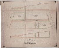
| SD7th-Grading-55thBalt |
|
Plan for grading Fifty-fifth Street from Baltimore Ave. to West Chester R.R., Fortieth Ward. | Gillingham, J. Harvey | 1904 |
Tracing
13 x 23 in.
Not noted
|
Southwest Philadelphia
Grading plan, showing amount of cutting and filling needed to bring street to regulated curb height. This street was in the valley of Thomas Run, a Cobb's Creek tributary.
|
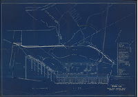
| SD7th-HogIsland1930 |
|
Hog Island [Shipyard] plant and property, general plan. Location topography & boundries [sic]. United States Shipping Board, Merchant Fleet Corporation. As of May 15, 1930. | Thurber, R.K., Reserve Fleet Division | 1930 |
Blueprint
Determine after scanning
1 inch = 400 feet
|
Southwest Philadelphia and Tinicum Township, Delaware County.
Shows this Delaware River shipyard as it was in the process of being dismantled. 51 shipways identified, along with 74 buildings, some with specific uses. Buildings 36-42 constituted the shipyard's sewage disposal plant.
|
| SD7th-HWY4-01 |
|
Plan showing 69th Street from Girard Ave. to Malvern Ave. Made for Highway Committee only. | Johnson, Joseph | 1916 |
Tracing
13 x 38 in.
1 inch = 100 feet
|
West Philadelphia, Indian Creek.
Indian Creek running roughly parallel to unopened street, building footprints. Note: "Probably damage for land taken $5,500. Probably claim for filing adjacent land $80,500"
|
| SD7th-HWY4-67th |
|
Plan of Sixty-seventh Street between Haverford Street and Leeds Street. For use of the Highway Committee only. | Johnson, Joseph | 1900 |
Tracing
48 x 30 in.
Not noted
|
West Philadelphia
Shows cemetery of Haddington M.E. Church with graves in the lines of the widened street. Attachment shows entire cemetery.
|
| SD7th-HWY4-67th-att |
|
Haddington M. E. Church Cemetery, 67th and Haverford sts. | Not named | 1900 ca. |
Tracing
27 x 11 in.
Not noted
|
West Philadelphia
Plan of cemetery with all plot owners named. "East line of 67th Street" cuts off about a third of the cemetery. A list of 13 burials at the top of this attachment corresponds with the 13 graves shown on SD7th-HWY4-67th that fall within the street lines.
|
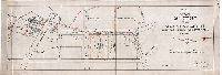
| SD7th-JP10-01 |
|
Plan for taking certain ground adjoining Fairmount Park as an open public place for the health and enjoyment of the people. Authorized by ordinance of Councils approved December 4th 1901. For use of Road Jury only. | Johnson, Joseph | 1902 |
Tracing
30 x 60 in.
Not noted
|
West Philadelphia. Property bounded by Windermere Ave., Ridgeland Ave., and Duhring or Steinberg Ave.
Park boundaries, building footprints on Anderson property
|
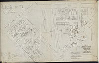
| SD7th-JP1-01 |

|
Plan of Lancaster Avenue from Market St. to 49th St.. For use of Jury. | Hancock, George W. | 1876 ca. |
Mounted
13 x 135 in.
Not noted
|
West Philadelphia
Building footprints, property owners and report (partial) on this plan
|
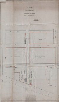
| SD7th-JP1-02 |
|
Plan of Forty-first Street from Market St. to Warren St. For use of Jury. Surveyed by [blank]. | Not named | 1880 ca. |
Tracing
10 x 55 in.
Not noted
|
West Philadelphia
Building footprints, property lines and owners. On reverse: "42.C3"
|
| SD7th-JP-176 |
|
Plan made for use of a Road Jury in the matter of the opening of Kingsessing Avenue from 42nd to 45th St. and Woodland Avenue from 42nd to 43rd St., 27th Ward, Phila., showing properties affected thereby. | Jones, William H. | 1893 |
Tracing
27 x 43 in.
1 inch = 50 feet
|
West Philadelphia. Bounded by 46th St., Woodland Ave. and Chester Ave.
Building footprints, property owners, profile of Mill Creek valley where crossed by several streets
|
| SD7th-JP-176-supplement |
|
Benefit plan showing properties within the bounds of 41st St., West-Chester and Phila. R.R., Woodland and Chester Aves., 27th Ward, Phila. Made supplementary to plan prepared for use of Road Jury in the matter of the opening of Kingsessing Ave., etc. etc. | Jones, William H. | 1893 |
Tracing
27 x 43 in.
1 inch = 100 feet
|
West Philadelphia
Building footprints, property owners
|
| SD7th-JP2-01 |
|
Plan of Haverford St. from 46th St. to Markoe St. For use of Road Jury only. "Note:…By reason of heavy fill…the curb has settled." | Johnson, Joseph | 1896 |
Tracing
13 x 23 in.
Not noted
|
West Philadelphia. Mill Creek valley
House lots, Pennsylvania Hospital for the Insane, curb settled because of heavy fill
|
| SD7th-JP3-51st |
|
Plan for the opening of Fifty-first Street from Lancaster Ave. to Merion Ave. For use of Road Jury only. | Johnson, Joseph | 1897 |
Tracing
22 x 19 in.
Not not+A414:O414ed
|
West Philadelphia
Property owners, profile of street showing grade change. Note on plan: Report of Jury filed 7/8/99 - confirmed 3/12/00"
|
| SD7th-JP3-DIN |
|
Plan of the change of grade of D'Invillier Street between City Ave. and Conshohocken Ave. For the use of the Road Jury only. | Johnson, Joseph | 1894 |
Tracing
36 x 32 in.
Not noted
|
West Philadelphia
Property owners, profile of street showing grade change
|
| SD7th-JP4-01 |

|
Plan for the condemnation of property for school purposes. Northwest side of Peach St. near Lansdowne Ave. For use of Road Jury only. [Attached: Report on property value from Joseph Johnson] | Johnson, Joseph | 1897 |
Tracing
14 x 28 in.
Not noted
|
West Philadelphia
|
| SD7th-JP5-01 |

|
Plan showing change of grade of Race Street between Fishers Ave. & 57th Street. For use of the Road Jury only. | Johnson, Joseph |
Tracing
24 x 36 in.
Not noted
|
West Philadelphia. Bounded by Chelsea St. to Cherry St., 57th St. to Fishers Ave.
Building footprints, property lines and owners, profile of natural ground surface and confirmed grade.
|
|
| SD7th-JP6-01 |

|
Plan for the opening of Arch St. from Salford St. to 60th St. Authorized by ordinance of Councils approved 8-13-1910. For use of Road Jury. Lines confirmed 8-11-1860. Grades confirmed 12-20-1880. | Johnson, Joseph | 1911 |
Tracing
20 x 27 in.
1 inch = 40 feet
|
West Philadelphia.
Building footprints, property lines and owners, profile of natural ground surface and confirmed grade, fountain pen as north arrow with initials T.E.L..
|
| SD7th-JP9-01 |
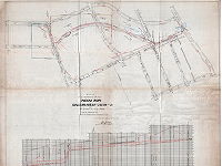
|
Plan of the construction of sewer (Indian Run) in Malvern Ave., 68th St., & 66th St. from 68th St. to City Ave. For use of Road Jury only. Authorized by ordinance of Councils approved July 19, 1902. Lines & grades confirmed 8-21-1899 & 12-9-1892. | Johnson, Joseph | 1904 |
Tracing
48 x 37 in.
Not noted
|
West Philadelphia
Street lines, creek, profile of sewer
|
| SD7th-JP9-02 |
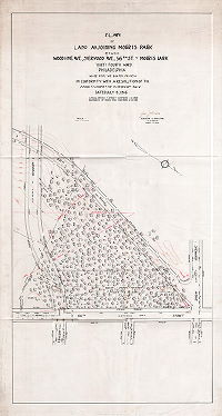
|
Plan of land adjoining Morris Park between Woodbine, Sherwood Ave., 66th St. and Morris Park, Thirty-fourth Ward, Philadelphia. Made for the Board of View in conformity with a resolution of the Commissioners of Fairmount park dated July 12, 1916. Lines and grades of streets confirmed 1-4-1909. Boundaries of Morris Park confirmed 12-29-1915. | Johnson, Joseph | 1916 |
Tracing
45 x 24 in.
1 inch = 50 feet
|
West Philadelphia. Triangle of woodland (now part of Morris Park) bounded by proposed extension of Woodbine Ave., 66th St., and proposed extension of 68th St.
Topography, trees, property owners. 68th St. was meant to run atop the Indian Creek Sewer, which was never built. The extension of Woodbine Ave. was also not built.
|
| SD7th-JP-NOM-26 |

|
Jury plan of main sewer constructed in Robinson Street from a point 150 ft. south of Vine St. to Haverford St., in Haverford St. from Robinson St. to 62nd St., and Haverford St. from 62nd St. to Lansdowne Ave. For use of the Road Jury only. | Johnson, Joseph | 1900 |
Tracing
32 x 51 in.
Not noted
|
West Philadelphia. Course of unnamed stream from Haverford Ave. to Vine St., roughly running between 62nd and 63rd streets.
Property lines and owners, profile along line of sewer showing original ground surface. This stream, captured by the sewer, began south of Lansdowne Ave. and emptied into Cobbs Creek near 63rd St. and Market St. See plan SD7th-P13-F1-2 for downstream sect
|
| SD7th-JP-NOM-28 |
|
Plan showing cuts & fills required to bring these lots from present physical condition to established street grades. Made for Dept. of Law in connection with Plan No. 10366V dated 5-13-30. | Hyde, George W. | 1932 |
Tracing
36 x 46 in.
1 inch = 30 feet
|
West Philadelphia. Vicinity of 69th St. and Haverford Ave., in valley of Indian Creek.
Calculations showing the amount of fill necessary in this vicinity, along Indian Creek, to bring the property up to the regulated street grade.
|
| SD7th-JP-NOM-31 |
|
Plan of the opening of Hunter's Avenue between 54th and 56th Streets. For the use of the Road Jury only. | Johnson, Joseph | 1894 |
Tracing
29 x 35 in.
Not noted
|
West Philadelphia.
Property lines and owners, footprint of 3-story stone mill, once along Mill Creek, property subdivision
|
| SD7th-Kirkbride1 |
|
[No title. Topographic plan of Pennsylvania Hospital for the Insane, with buildings identified by use. | Not named | 1921 ca. |
Tracing
30 x 43 in.
Not noted
|
West Philadelphia. Market St. to Haverford Avenue, 42nd St. to 49th St.
Building footprints (identified by use) of Pennsylvania Hospital for the Insane, male and female departments. Dated in pencil: "1921 or 1922."
|
| SD7th-Kirkbride2 |

|
Plan of property in the 24th Ward made for Provident Trust Co. Note: Plan made for title purposes only [and] according to the instructions of the applicant. | Hyde, George W. | 1929 |
Tracing
24 x 33 in.
Not noted
|
West Philadelphia. Market St. to Haverford Avenue, 42nd St. to 46th St.
Building footprints of Pennsylvania Hospital for the Insane, female department.
|