
Philadelphia Streets Department Surveys
2755 result(s). Showing results 2451 to 2500.
View page: 1 2 3 4 5 6 7 8 9 10 11 12 13 14 15 16 17 18 19 20 21 22 23 24 25 26 27 28 29 30 31 32 33 34 35 36 37 38 39 40 41 42 43 44 45 46 47 48 49 50 51 52 53 54 55 56 (Show all on one page)
| Identifer | Preview | Title | Surveyor | Date | Media / Size / Scale | Area / Map Features |
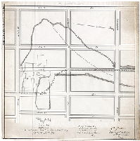
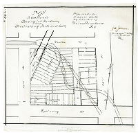
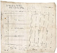
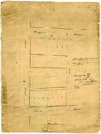
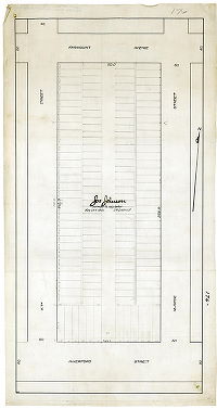
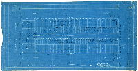
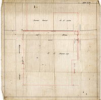
| SD7th-Kirkbride3 |
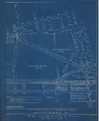
|
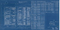
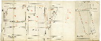
The Pennsylvania Hospital Site. Proposed Plot Plan No. 3. The Philadelphia Housing Authority. The Technical Board. PHA-39 | Not named | 1938 |
Blueprint
38 x 32 in.
Not noted
|
West Philadelphia. Market St. to Haverford Avenue, 42nd St. to 46th St.
Shows two triangular areas "available for housing", a new diagonal street, and a traffic circle at 42nd St. and Powelton Ave.
|
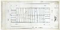
| SD7th-Kirkbride3-Report |
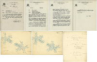
|
[Report and plans from George T. Shegog, surveyor and regulator, 11th Survey District, to Thomas Buckley, assistant engineer, Bureau of Engineering, Surveys and Zoning, City of Philadelphia, regarding plan to develop the Pennsylvania Hospital for Insane Property for public housing and bisect it with a diagonal street. Shegog recommended this street as a necessary barrier between the while residents on one side and African-American (which he called "colored") residents on the other side. | Shegog, George T. | 1939 |
Paper
|
West Philadelphia
Property subdivision
|
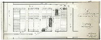
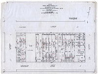
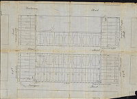
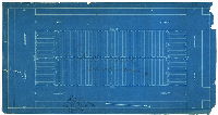
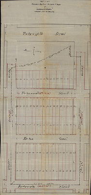
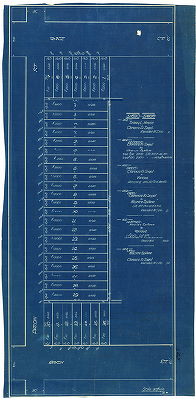
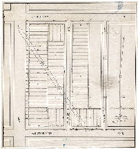
| SD7th-Kirkbride4 |
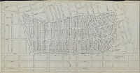
|
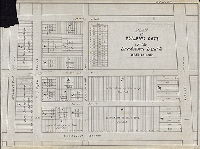
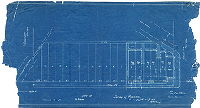
[No title. Plan showing Pennsylvania Hospital for the Insane property divided into 1632 house lots, with calculations for necessary cuts and fills to bring the property to regulated street grade. Probably made in conjunction with Philadelphia Housing Authority (see plan SD7th-Kirkbride3] | Not named | 1940 ca. |
Tracing
29 x 56 in.
Not noted
|
West Philadelphia. Market St. to Haverford Avenue, 42nd St. to 49th St.
Shows 1632 house lots, with calculations of cubic yards of cuts and fills needed to prepare the site for construction. This plan was never executed; public housing towers were built on the eastern half of the property.
|
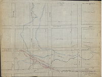
| SD7th-Kirkbride5 |
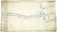
|
[No title. Mill Creek between Market Street and Haverford Avenue, through the Pennsylvania Hospital for the Insane, with 46th Street projected over the creek.] | Not named | 1889 |
Tracing
13 x 22 in.
Not noted
|
West Philadelphia, Mill Creek.
Mill Creek, Pennsylvania Hospital for the Insane
|
| SD7th-Law1-LPP-274 |
|
Plan of creeks between Lansdowne Ave. and Paschall St., 57th and 55th St. Plan made for H. Oscar Smith by the order of the Law Department. No. 1. | Johnson, Joseph | 1894 |
Tracing
17 x 16 in.
Not noted
|
West Philadelphia, Mill Creek.
Shows Mill Creek sewer running under private property
|
| SD7th-Law2-SPP-287 |
|
Plan of lots between 55th and 55-1/2 St., Paschall to Media St. with streets running east and west. Plan made for H. Oscar Smith by the order of the Law Department. No. 2. | Johnson, Joseph | 1894 |
Tracing
10 x 25 in.
Not noted
|
West Philadelphia, Mill Creek.
Shows Mill Creek sewer running under private property
|
| SD7th-Law3-LPP-287 |
|
Plan of lots between 55th and 55-1/2 St., Paschall to Media St. with streets running north and south. Plan made for H. Oscar Smith by the order of the Law Department. No. 3. | Johnson, Joseph | 1894 |
Tracing
21 x 12 in.
Not noted
|
West Philadelphia, Mill Creek.
Shows Mill Creek sewer running under private property
|
| SD7th-Law4-SPP-244 |
|
Plan of Suplee property with profile of present and old line of embankment. Plan made for H. Oscar Smith by the order of the Law Department. No. 4. | Johnson, Joseph | 1894 |
Tracing
19 x 12 in.
Not noted
|
West Philadelphia, Mill Creek.
Shows Mill Creek sewer running under private property
|
| SD7th-Law5-SPP-244 |
|
Plan of Suplee property showing lot subdivision and street running north and south. Plan made for H. Oscar Smith by the order of the Law Department. No. 5. | Johnson, Joseph | 1894 |
Tracing
12 x 12 in.
Not noted
|
West Philadelphia, Mill Creek.
Shows Mill Creek sewer running under private property
|
| SD7th-LPP-001 |
|
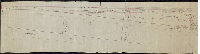
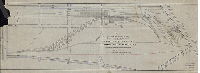
Pennsylvania Railroad, Philadelphia Improvements, Pennsylvania Terminal Are. Record of Schuylkill River Flood, August 23rd to 28th, 1933. Office of Assistant Engineer, West Phila, Sept. 1, 1933. M-9053. | Not named | 1936 |
Blueprint
20 x 30 in.
1 inch = 400 feet
|
Schuylkill River front, both banks, from Spring Garden St. to South St.
Plan amended twice: "July 11, 1935, added record of flood of July 9th & 10th, 1935" and "Feb. 27, 36, added flood protection dike"
|
| SD7th-LPP-003 |
|
[No title. Schuylkill River front from Wire Bridge to Powelton Avenue, showing 30th Street extended.] | Hancock, George W. | 1880 ca. |
Tracing
10 x 20 in.
1 inch = 100 feet
|
Schuylkill River
Wharves
|
| SD7th-LPP-009 |
|
Plan of proposed subdivision made for Eugene H. and Peter F. Carroll, Fortieth Ward, Philadelphia. | Engle, Amos B. | 1925 |
Tracing
21 x 36 in.
1 inch = 40 feet
|
West Philadelphia. Bounded by Dicks Ave. to Grovers Ave., 65th St. to 67th St.
Property subdivision
|
| SD7th-LPP-035 |
|
Jas. And Chas. A. Maguire, 1432 So. Penn Square, Phila. | Not named | 1895 ca. |
Tracing
15 x 16 in.
1 inch = 16 feet
|
West Philadelphia. Plan of lots at corner of 35th St. and Powelton Ave.
Property subdivision
|
| SD7th-LPP-060 |
|
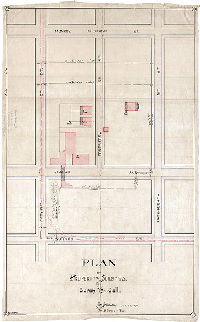
Plan showing proposed condemnation as a recreation center the plot of ground the buildings etc. erected bounded by 36th, 37th, Brandywine, & Haverford Sts. In the 24th Ward, as per ordinance introduced July 12, 1923. Probable damage $136000. | Not named | 1923 |
Tracing
19 x 25 in.
|
West Philadelphia
Property lines and owners, with each property assigned a dollar value. A recreation center was not built at this location.
|
| SD7th-LPP-089 |
|
Jas. And Chas. A. Maguire, Dec. 13th, 1895 | Not named | 1895 |
Blueprint
15 x 21 in.
1 inch = 30 feet
|
West Philadelphia, bounded by Poplar St. to Wyalusing St., 38th St. to 39th St.
Property subdivision
|
| SD7th-LPP-103 |
|
[No title. Plan of lots with sewer connections on Penngrove (now Pennsgrove) Street between 39th and 40th streets. "Plan made previous to building"] | Johnson, Joseph | 1903 |
Tracing
11 x 24 in.
Not noted
|
West Philadelphia.
Property subdivision
|
| SD7th-LPP-112 |
|
Surveyed by Sam. L. Smedley, Surv. & Reg. 11th Dist., per Hancock. [On reverse: "Old plan of lots at 41st and Aspen. N-35-C3. Joshua Clendenon, 528 Walnut St., City"] | Smedley, Samuel L. | 1871 |
Mounted
19 x 14 in.
Not noted
|
West Philadelphia
Property subdivision
|
| SD7th-LPP-124 |
|
[No title. Plan showing extension of Fairmount Avenue north of 42nd Street, through all or part of several buildings.] | Not named | 1880 ca. |
Tracing
12 x 18 in.
Not noted
|
West Philadelphia
Building footprints, property lines and owners. Note on reverse indicates this was a road jury plan, from Box (now Folder) 2
|
| SD7th-LPP-143 |
|
[No title. Plan of house lots between Pennsgrove and Wyalusing streets, from 42nd to 43rd streets] | Not named | 1890 |
Tracing
16 x 22 in.
Not noted
|
West Philadelphia
Property subdivision, building footprints
|
| SD7th-LPP-147 |
|
Property of Mr. F. A. Poth. 1/16 in. scale. | Not named | 1900 |
Blueprint
19 x 28 in.
1 inch = 16 feet
|
West Philadelphia. 42nd St. and Parkside Ave.
Property subdivision, building footprints. On reverse, in pencil: Calculations of cutting and filling necessary to bring property to regulated street grade.
|
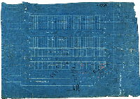
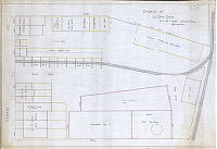
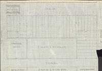
| SD7th-LPP-161 |
|
Plan made for the use of the Board of Viewers in the matter of the appropriation and acquisition of certain land as part of the site of the Mill Creek Project. Project No. PA 2-17. 44th Ward Philadelphia. Authorized by resolution of Phila. Housing Authority. | Barton & Martin | 1952 |
Blueprint
32 x 60 in.
1 inch = 20 feet
|
West Philadelphia. Bounded by Lex Ave. to 46th St. Fairmount Ave. to Aspen St.
Building footprints; list of owners and descriptions of properties to be acquired. About a dozen vacant lots had no registered owners.
|
| SD7th-LPP-167-1 |
|
Plan of building los of the Lansdown Land Co. West Philada. [Tracing copy of original]. Note in pencil: "Plan of the property of Sam'l. L. Smedley, 224 S. 5th St." | Not named | 1855 ca. |
Tracing
20 x 26 in.
Not noted
|
West Philadelphia. Bounded by Jefferson St. to Lansdowne Ave., Monument Rd. to Belmont Ave.
Property subdivision
|
| SD7th-LPP-167-2 |
|
No. 26049. Eastern Region. P.T. Div. P.R.R. [Pennsylvania Railroad] Siding & coal yard facilities, George B. Newton Coal Co., Inc. Belmont Ave. & Thompson St., Philadelphia, PA. | Thorn, C. W. | 1931 |
Blueprint
19 x 55 in.
Not noted
|
West Philadelphia. Southwest corner, Belmont Ave. and Parkside Ave.
Building footprints, including York Ice Machinery Co., Direct Coal Co., Diamond Coal Co., Margolis Coal Co. a 26 stall engine house, stables, harness shop, and the Railroad YMCA athletic field, grandstand and locker room
|
| SD7th-LPP-167-3 |
|
P.R.R. [Pennsylvania Railroad]. P. T. Division. Property to be leased to Edward Gottlieb, Parkside and Belmont Aves., Philadelphia, PA. | Not named | 1944 |
Blueprint
19 x 43 in.
1 inch = 40 feet
|
West Philadelphia. Southwest corner, Belmont Ave. and Parkside Ave.
Building footprints, including York Ice Machinery Co., reinforced concrete coal silos, Keystone Coal Co., Diamond Coal & Fuel Co., a 26 stall engine house, and other structures
|
| SD7th-LPP-176A |
|
[No title. One of five plans showing lot and street layouts between 47th and Markoe streets, from Haverford to Fairmount avenues. This ground was underlaid by a curving section of the Mill Creek Sewer (not noted on any of the plans); the pipe passed directly beneath a number of houses.] | Johnson, Joseph | 1901 |
Tracing
21 x 11 in.
Not noted
|
West Philadelphia, on line of Mill Creek Sewer, 47th St. and Haverford Ave.
Property subdivision
|
| SD7th-LPP-176B |
|
[No title. One of five plans showing lot and street layouts between 47th and Markoe streets, from Haverford to Fairmount avenues. This ground was underlaid by a curving section of the Mill Creek Sewer (not noted on any of the plans); the pipe passed directly beneath a number of houses.] | Not named | 1901 ca. |
Blueprint
11 x 20 in.
Not noted
|
West Philadelphia, on line of Mill Creek Sewer, 47th St. and Haverford Ave.
Property subdivision
|
| SD7th-LPP-176C |
|
[No title. One of five plans showing lot and street layouts between 47th and Markoe streets, from Haverford to Fairmount avenues. This ground was underlaid by a curving section of the Mill Creek Sewer (not noted on any of the plans); the pipe passed directly beneath a number of houses.] | Johnson, Joseph | 1901 |
Tracing
11 x 21 in.
Not noted
|
West Philadelphia, on line of Mill Creek Sewer, 47th St. and Haverford Ave.
Property subdivision
|
| SD7th-LPP-176D-1 |
|
[No title. One of five plans showing lot and street layouts between 47th and Markoe streets, from Haverford to Fairmount avenues. This ground was underlaid by a curving section of the Mill Creek Sewer (not noted on any of the plans); the pipe passed directly beneath a number of houses.] | Johnson, Joseph | 1903 |
Tracing
11 x 23 in.
Not noted
|
West Philadelphia, on line of Mill Creek Sewer, 47th St. and Haverford Ave.
Property subdivision
|
| SD7th-LPP-176D-2 |
|
[No title. One of five plans showing lot and street layouts between 47th and Markoe streets, from Haverford to Fairmount avenues. This ground was underlaid by a curving section of the Mill Creek Sewer (not noted on any of the plans); the pipe passed directly beneath a number of houses. This blueprint is a working copy, noting the location of stakes marking building lines, cuts and fills, and other information. Reverse also scanned.] | Johnson, Joseph | 1903 |
Blueprint
11 x 20 in.
Not noted
|
West Philadelphia, on line of Mill Creek Sewer, 47th St. and Haverford Ave.
Property subdivision
|
| SD7th-LPP-179 |
|
Copy of James M. Morrison's plan of "Ellangowan" compiled from the records. | Not named | 1880 ca. |
Tracing
30 x 15 in.
Not noted
|
West Philadelphia. Bounded by 46th St. to 48th St., Aspen St. to Brown St.
Property subdivision
|
| SD7th-LPP-206 |
|
[No title. Mill Creek and Mill Creek Sewer from 54th and Suplee streets to 56th Street and Lancaster Avenue.] | Not named | 1900 ca. |
Tracing
45 x 23 in.
Not noted
|
West Philadelphia
Later note added, indicating property on the 5400 block of Suplee Street, south side: "Billed 143' 11-3/4" of Sewer @$1.50 per ft. = $215.91. 2-16-1951. Nathan Schwartz & Sons."
|
| SD7th-LPP-223 |
|
Plot Plan. Operation 52nd & Parkside Ave. Messrs. Margolin & Block. | Not named | 1910 ca. |
Blueprint
14 x 19 in.
Not noted
|
West Philadelphia
Property subdivision, building footprints
|
| SD7th-LPP-225-1 |
|
[No title. Lot plan on Paxon, Arch and Race Streets, with record of deeds, ground rents, and mortgages between Sidney L. Krauss, Clarence R. Siegel, and Maurice Spillane. ] | Not named | 1902 |
Blueprint
23 x 11 in.
1 inch = 30 feet
|
West Philadelphia
Property subdivision. On reverse, in pencil: Calculations of cutting and filling necessary to bring property to regulated street grade.
|
| SD7th-LPP-225-2 |
|
Lot plan, w[est] s[ide] 51st St. bet[ween] Arch and Race. Pugh & Downing, Architects. | Pugh & Downing | 1900 ca. |
Blueprint
11 x 19 in.
1 inch = 20 feet
|
West Philadelphia
Property subdivision, building footprints. On reverse, in pencil: Calculations of cutting and filling necessary to bring property to regulated street grade.
|
| SD7th-LPP-229-1 |
|
[No title. Plan of lots "made previous to building" on Hoopes Street and Westminster Avenue between 51st and 52nd streets, showing Mill Creek sewer running diagonally under private property.] | Johnson, Joseph | 1903 |
Tracing
18 x 24 in.
Not noted
|
West Philadelphia
Property subdivision, Mill Creek Sewer. Note added in red: "Stakes were not followed and walls were carelessly built."
|
| SD7th-LPP-229-2 |
|
[No title. Plan of lots "made subsequent to building" on Hoopes Street between 51st and 52nd Streets, showing Mill Creek sewer running diagonally under houses.] | Johnson, Joseph | 1907 |
Tracing
12 x 24 in.
Not noted
|
West Philadelphia
Property subdivision, Mill Creek Sewer running beneath house lots
|
| SD7th-LPP-229-3 |
|
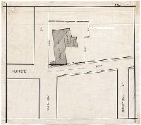
Plan of property belonging to the Thomas W. Price est[ate]. C. E. Rahn, Architect. 410 Walnut St. Phila. [On reverse, in pencil: John Megraw, 407 Land Title Bldg."] | Rahn, C. E. | 1900 ca. |
Blueprint
12 x 24 in.
1 inch = 32 feet
|
West Philadelphia
Property subdivision
|
| SD7th-LPP-230-1 |
|
[No title. Plan of property at 52nd Street and Westminster Avenue.] | Not named | 1880 ca. |
Tracing
22 x 22 in.
Not noted
|
West Philadelphia
Owner names include M. H. Suplee, C. C. Pierson, and "burial ground." Mill Creek appears as a diagonal pencil squiggle.
|
| SD7th-LPP-230-2 |
|
[No title. Plan of lots between, Westminster Avenue and Wyalusing Street, on 52nd, Creighton, and Paxon streets. Mill Creek Sewer is shown running diagonally under private property.] | Johnson, Joseph | 1899 |
Tracing
22 x 20 in.
Not noted
|
West Philadelphia
Property subdivision, Mill Creek Sewer
|
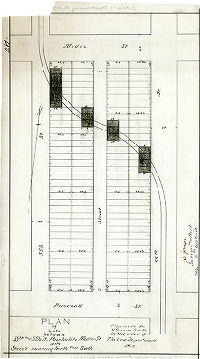
| SD7th-LPP-244 |
|
Surveyed for the heirs of Israel Suplee, Aug. 13th 1851, by John Levering. | Levering, John | 1851 |
Tracing
18 x 23 in.
Not noted
|
West Philadelphia, bounded roughly by Torr Ave. to Wyalusing St., 55th St. to 52nd St.
Property partition between Wyalusing and Girard avenues, 52nd and 55th streets. Names on map include Mrs. Ann Suplee, Ann Jane Suplee, and Frances Suplee. Plan shows Mill Creek and various mill ponds and races, and several building footprints, bridges, an
|
| SD7th-LPP-244-1 |
|
Surveyed by Geo. W. Hancock 3/30/80. | Hancock, George W. | 1880 |
Tracing
9 x 22 in.
Not noted
|
West Philadelphia. Property near 52nd St. between Arch St. and Market St.; and other parcels in are bounded by 52nd St. to 55th St., Girard Ave. to Wyalusing Ave.
Property partition. On reverse: "128. Copy of plan of partition of estate of Benj. Suplee. Case 2-8A-#128"
|
| SD7th-LPP-244-2 |
|
Survey of Premises. [Plan showing subdivision at 52nd Street and Girard Avenue, with four different styles of house depicted.] | Not named | 1900 |
Blueprint
14 x 26 in.
1 inch = 16 feet
|
West Philadelphia, 52nd St. between Poplar St. and Girard Ave.
Property subdivision, with 18 house lots and four house styles depicted
|
| SD7th-LPP-272 |
|
Plan of property and buildings of Sarah Yewdall. | C. Garrett, delineator. | 1894 |
Tracing
26 x 16 in.
Not noted
|
West Philadelphia, bounded by Monroe St. to Supplee St., 54th St. to 55th St.
Footprints of factory buildings, five wells, and Mill Creek Sewer
|
| SD7th-LPP-276 |
|
[No title. Outlines of mill buildings at 55th Street and Hunter's Lane.] | Not named | 1894 |
Tracing
14 x 16 in.
Not noted
|
West Philadelphia. Buildings at 55th St. and Hunter's Lane
These are likely part of James and John Hunter's textile factory. As West Philadelphia's residential housing expanded westward, rowhouses were built on this property.
|
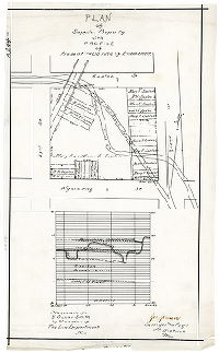
| SD7th-LPP-278-1 |
|
[No title. On reverse: "Pennsylvania I.W. Co." | Not named | 1872 ca. |
Tracing
12 x 44 in.
Not noted
|
West Philadelphia. 49th to 52nd Sts., between Merion Avenue and the railroad tracks.
Pennsylvania Railroad tracks sidings into a coal and lumber yard, "sheep siding" into the Sheep Brokers Association property. Building footprints, property owners including Isaac Heston and William L. Elkins
|
| SD7th-LPP-278-2 |
|
Plan of revision of lines and grades on that portion of the 34th Ward lying between Belmont Ave. and 52nd St. and Columbia Ave. and Merion Ave. Authorized by ordinance approved Nov. 8th, 1894, and Dec. 28th, 1895, and April 7th, 1898. Confirmed by the Board of Surveyors Jan. 3, 1899. | Johnson, Joseph | 1894 |
Tracing
17 x 45 in.
Not noted
|
West Philadelphia. Bounded by Leidy Ave. to Merion Ave and Girard Ave., Belmont Ave. to 52nd St.
Pennsylvania Railroad tracks, sidings, stations, and other building footprints
|
| SD7th-LPP-278-3 |
|
Property of W. Price Davis, 4601 to 4633 Girard Ave. Philadelphia | Not named | 1900 ca. |
Tracing
22 x 15 in.
Not noted
|
West Philadelphia. 4600 block of Girard Ave.
Railroad siding, mill building, Columbia Tea Co., kiln building for terra cotta works, and various stables, houses, and offices.
|
| SD7th-LPP-289 |
|
Building operation. 40 houses. Wm. A. Arthur and Bro. 219-221 N. 63rd St., West Philada. 1894 | Not named | 1894 |
Tracing
17 x 24 in.
Not noted
|
West Philadelphia. 56th to 55-1/2 St., Hunter Ave. to Jefferson St.
Property subdivision. Plan also locates other houses built by John Hunter, and Hunter & Nock
|
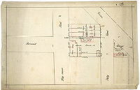
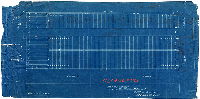
| SD7th-LPP-291a |
|
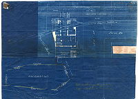
[No title. Pennsylvania Railroad station at 52nd Street and Lancaster Avenue] | Not named | 1901 |
Blueprint
14 x 19 in.
Not noted
|
West Philadelphia
Plan shows location of waiting room, ticket booth, newsstand, toilets, and elevators to platforms for both Main Line and Schuylkill Division trains.
|
| SD7th-LPP-291b |
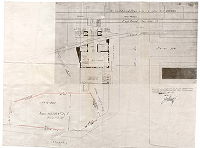
|
[No title. Pennsylvania Railroad station at 52nd Street and Lancaster Avenue] | Not named | 1901 |
Photostat
14 x 19 in.
Not noted
|
West Philadelphia
Plan shows location of waiting room, ticket booth, newsstand, toilets, and elevators to platforms for both Main Line and Schuylkill Division trains. This copy includes a typed note: "The title to the above is in The Pennsylvania Railroad by Deed dated Jul
|